This month has been quite rainy for the southern US, but for a strip from the north central to the mid-Atlantic, it has been quite dry for a couple of weeks. It all started with an omega block, which we identified with our forecast in Allentown. Allentown remained dry, despite some storms in the area on the 6th of June, and it was quickly followed by the apocalyptic smoke that descended on the region. A little rain on any number of tracts of land between northern Canada and Allentown would have been great, but it was not to be. Victoria-Weather’s forecast sparkled, and the victory was ours. Actuals: June 5th, High 77, Low 48 June 6th, High 79, Low 52
Charlotte and Allentown are definitely Eastern cities, but they have the good fortune of not being along the Coast. This means that our route can take I-81, which is windier, hillier and otherwise more scenic, while also avoiding the traffic of I-95. It will take a day to get from North Carolina to our destination in Pennsylvania, at a pace of 66.4mph.
Charlotte, North Carolina
There are a few clouds streaming across the Coastal Plains as low pressure churns off the coast of New England. The low will drift to Nova Scotia, while breezier and relatively cool air continues to press south. The flow will be coming up an over the Appalachians, so relative to the conditions throughout the rest of Vieginia, expect clearer skies. As we pass west of Baltimore, we will get north of the front, which will shear away the remaining threat of wet weather. Allentown will be delightful and awaits our arrival.
I know some people that live in Allentown, and they commute to New York City at times if they need to go in the office. Can you imagine, potentially going through three states in a day just to get to work? We’re only going to be looking at Allentown though, and limit our scope to just the one state.
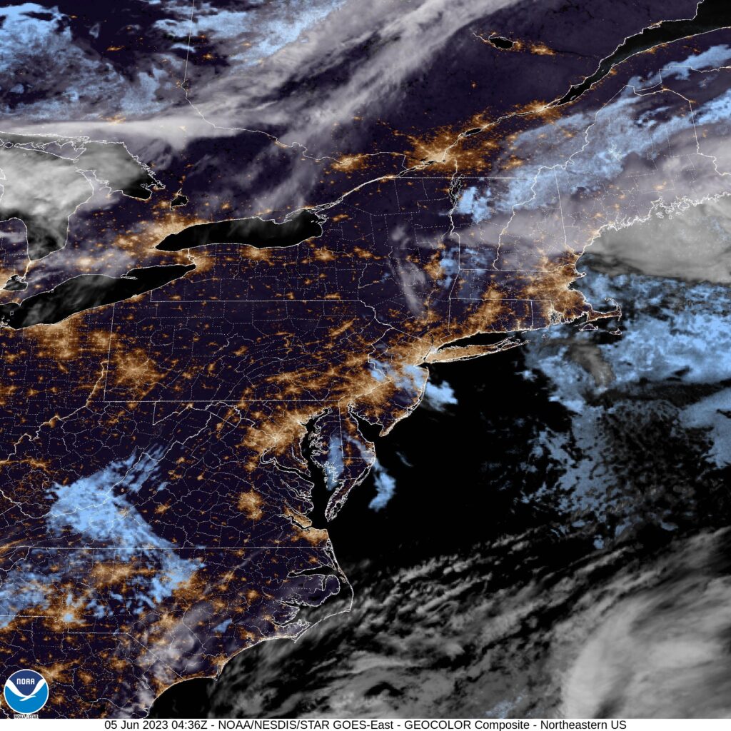
AT 1051PM, ET, Allentown was reporting clear skies and a temperature of 54 degrees. Clear skies are seen across the region. Allentown is at te eastern flank of an Omega Block across the middle of the country. Low pressure developing on the eastern flank of the features is rising north along the Coast, while a weak cool front off the tail of the system has recently passed Allentown, making life a bit more tolerable after a hot weekend. As is often the case with blocking patterns, don’t expect much change over the next couple of days. Low pressure will retrograde into Nova Scotia, and the boundary will stall. At varying instances, there may be some additional clouds, and some stronger north breeze. A light shower may crop up on Tuesday. Tomorrow – Partly cloudy, High 76, Low 48 Tuesday – Partly cloudy with a chance for light rain, High 80, Low 52
TWC: Tomorrow – Sunshine and clouds mixed. High 78, Low 47 Tuesday – Mostly sunny skies. High 78, Low 53
AW: Tomorrow – Intervals of clouds and sunshine High 77, Low 50 Tuesday – Partly sunny with a brief shower; smoke from distant wildfires can cause hazy skies and poor air quality High 77, Low 55
NWS: Tomorrow – Increasing clouds High 78, Low 48 Tuesday – A slight chance of showers, then a chance of showers and thunderstorms after 2pm. Sunny, High 78, Low 55
WB: Tomorrow – Sunny in the morning, then becoming partly sunny, High 77, Low 48 Tuesday – Mostly sunny. A chance of showers in the afternoon. High 77, Low 53
WN: Tomorrow – Partly cloudy, High 78, Low 49 Tuesday – Partly cloudy with isolated showers and storms, High 79, Low 54
CLI: Tomorrow – Mostly cloudy, High 75, Low 46 Tuesday – Light rain showers, High 75, Low 52
It’s pretty warm in the middle of the country, and it was this weekend in Allentown. What a terrific break this weather will be.