I have talked about “bright banding” in the past. It is the phenomenon in which snow forms striations on radar, with the brighter returns indicating elongated bands of heavy snowfall. Given the movement patterns of snow storms, these bands tend to linger and usually result in the locations that receive the most snow in a region’s snow event.
What happens, then, if there is only one band of snow in a withering area of low pressure, and it sets up in an area that is otherwise snow free? What this bright band would do is something like what happened earlier this week in Kansas, with a system that moved through the mid-Mississippi Valley, and ultimately became a blizzard in western New York and eastern Canada.
In the end, the snow band was less than 20 miles wide, but in some places more than a foot deep, and came down at a pace that required the closing of I-70 in northern Kansas. Certainly bad luck for the very few people that saw all the snow, but at least they didn’t need to go far to get out of it.
If you have been tracking the weather in the southeast over the last several weeks, you know that the we’ve had a bit more early severe weather than last year, particularly in the Dixie Alley of Mississippi, Alabama and states surrounding them.
The issue hasn’t really been the individual severity of these storms, but rather the frequency with which they have been occurring. Big thunderstorms often bring heavy rains, and while the southeast is uniquely equipped to contend with a higher water content than most places in the country, they have simply seen these storms too often.
Presently, the Mississippi is over it’s banks in Natchez, while the Tombigbee River in Alabama from Gainesville to Mobile is at moderate flood levels. The Pearl River, particularly in Jackson, is where the flooding is presently the worst. The Pearl is currently cresting at eight feed above flood stage.
If we were expecting to stay dry for a while, I would confidently say that the worst will soon be over for residents of Jackson and the surrounding environs, however the forecast calls for more rain. Many parts of Mississippi, including Jackson, will see at least a couple more inches of rain through Thursday, leading the WFO in Jackson to pain the region in Flash Flood watches and warnings.
Mississippi’s terrain is porous and will be able to absorb the excess faster than many places, but it is still significant to see flash flooding forecast over such a broad swath of land. The next round of rain and thunderstorms has already popped up south of Grenada.
Do you know what this site has been missing this winter? Posts about snow storms on the East Coast. this isn’t just because of our pared down content schedule either; there just hasn’t been any snow to speak of south of New York, and the biggest features have waited until they are over the Atlantic to really take off.
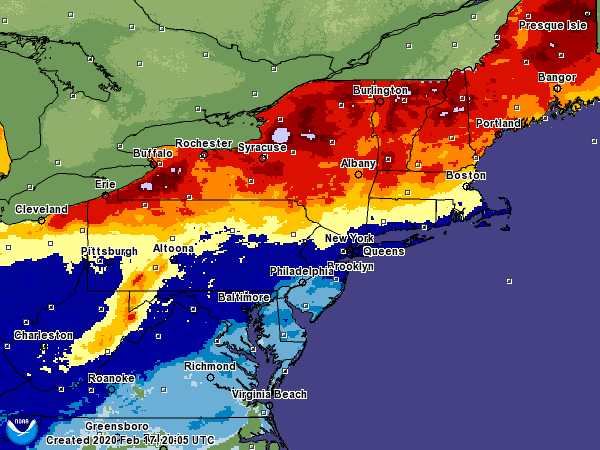
New York hasn’t been particularly snowy either, but Philadelphia and Washington have seen less than an inch of snowfall accumulation all season. Take a look at the accumulated totals for the mid-Atlantic to date this season.
The light blue shadings are the 0-1″ range, which includes southern New Jersey to northern North Carolina, at which point the total accumulations really taper off. Things are light north of there as well, with under half a foot falling from the Cape to southeastern Pennsylvania.
It hasn’t been dry along the East Coast. There have been plenty of warmer core systems that brought enough rain to make sure the soil stays saturated. There have also been cold snaps from time to time. The problem for snow lovers in the Beltway is that those two things haven’t phased.
It’s still only the middle of February, so hope is not all lost for people want to see some snow this season, but for those that aren’t snow aficianados, we are already almost out of the woods for the season, and it has passed with very little headache.
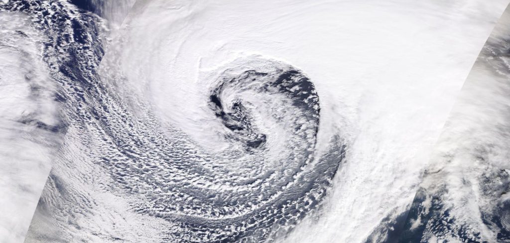
A strong storm with an origin in the southern United States underwent explosive cyclogenesis (a ‘bomb cyclone’) in the North Atlantic over the weekend and slammed into Ireland and the United Kingdom, bringing strong winds, heavy rain and disruption through the region.
Many European meteorological agencies give names to all significant systems. In this case, the United Kingdom, Ireland and the Netherlands form a cooperative that ascribes names to storms, much like the National Hurricane Center does to hurricanes. This is a tried and true method of weather agencies both to document and streamline the notifications of the strongest storms (and a lot of that is lost when networks give their own names to snow storms).
But the politics and naming conventions aside, Dennis was one of the strongest storms to ever move across the north Atlantic, thanks to a strong jet structure that fostered the rapid development. Usually, and once again this was the case, when there is such a rapid development, it is accompanied by very gusty winds.
With Dennis, however, the most significant impact was with the water. Churning seas claimed the lives of a couple of British citizens, while flood waters and heavy rains lead to the death of another man in Wales, and a woman was swept away by floodwaters in Worcestershire. There have also been stories of ships (though abandoned) washing ashore in Ireland thanks to the churning seas, and flooding as far away as Sweden as Dennis made his way towards the Baltic.
The storm has mostly shifted out of Europe, though a cold front remains particularly active in Russia and Belarus, though it tails as far west as France. A few snowflakes will fall in Scotland and northern England today, while runoff will continue to cause rivers to rise on Great Britain for at least another day or so.
To continue to follow Dennis and his lingering impacts, as well as learning more about individual tales and specific happenstances brought about by this massive storm, BBC News continues to have live updates about his wrath.
It is cold this morning in the Upper Midwest. For the second morning in a row, temperatures dropped to the double digits below zero across the regions. It’s the coldest it’s been all season, but there will be a bounce back this weekend, back to near freezing, if not above.
This little cold snap is not the last gasp that I am talking about.
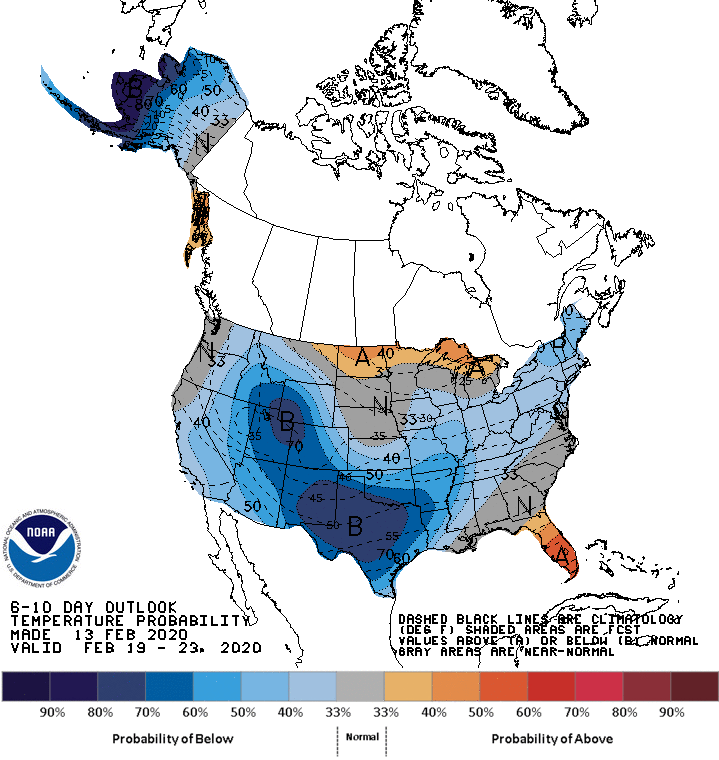
The cold snap I am referring to is the one forthcoming. It may not be too terrible in the north central United States, relatively speaking, but look at this spate of blue on the 6-10 day outlook from the CPC.
That’s a peculiar outlook, I will be the first to admit, and it has everything to do with systems generating in the Rockies, diving into the Big Bend of Texas and then shuttling off towards New England.
The good news is, much of the cool down is going to owe to the precipitation in the region, rather than an Arctic intrusion, which means, among other things, that despite the high precipitation and unseasonably low temperatures, west Texas probably won’t see accumulating snow out of this.
While this will be the pattern for the end of February and into the beginning of March, it will not hold through all the way through spring. Indeed, as luck would have it, this map will once again reverse for the rest of the season, as the north central US will be the spot most liely to endure a below normal spring.
January was interminable, wasn’t it? And here we are, 10 days later, still talking about. It’s mostly good news, though, because in the fray of January, we were able to reward not one, not two, but THREE outlets with the forecaster of the month award. The three outlets to draw level in the first month of the year were Victoria-Weather, Weatherbug and the Weather Service.
This year, there was a grand cluster of similarly competent forecasters. 5 Outlets were matched pretty well, but then there was one outlet that was very bad (sorry, Forecast.io) and one that was really good, but it took until December to realize how dominant they had been. Victoria-Weather won the month of December, while the ultimate winner for the year tied for second…. and that was all it took to finish well above the runner up this year. Congratulations to the Forecaster of the Year,
THE WEATHER CHANNEL!
For completeness, here is the chart of individual forecast wins. It shows that The Weather Channel didn’t necessarily have the highest peaks, but they were able to stay steady all year. Here’s to a wonderful 2020!
There were two remarkable weather stories this week, one for the raw statistics, and one for the incredible imagery.
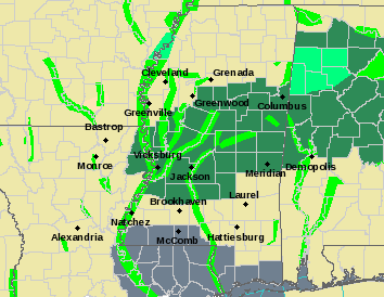
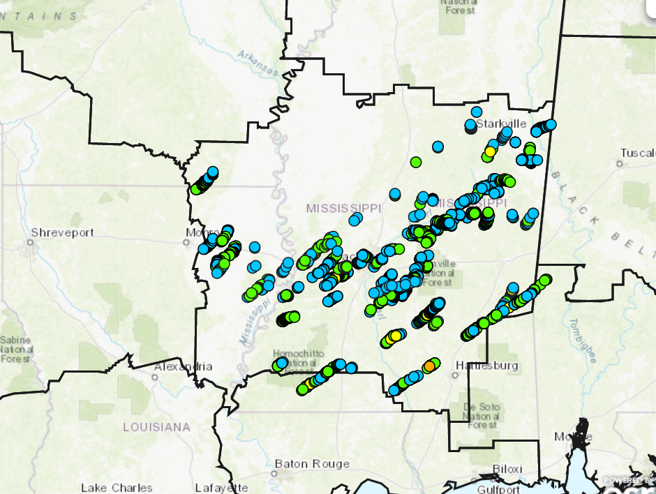
Last weekend, a strong late season storm swept through the Lower Mississippi Valley, unleashing a tornado outbreak from Louisiana to Alabama that was unusual for mid-December, but not altogether unheard of.
Mississippi was struck by nearly a dozen twisters, while two people were killed in northern Alabama. The most eye-popping number from the outbreak was the 64 mile tornado track in central Louisiana. The largest town clipped by this tornado was Alexandria, where there was extensive damage, but no deaths. There was one storm related fatality in Louisiana, however.
Take a look at the map the Jackson WFO put out, showing the tornado coverage there (unfortunately, there isn’t a good map that I’ve seen from Louisiana or Alabama with the tornado tracks), and find more details from NPR on the storm.
Also in the last week, a virulent but quick moving system brought a profundity of snow squall warnings through the mid-Atlantic and southern New England. Snow squall warnings are equivalent to severe thunderstorms, inasmuch as they move quickly, and bring about strong if short lived winds, even if they don’t bring a lot of accumulation.
Check out this clip of the storm consuming Manhattan
Wow! Check out this time lapse of the #SnowSquall moving over Manhattan. Crazy cool view from the top of One World Trade Center. pic.twitter.com/K7kxjcA0Zt
This all lead to very good news for Christmas travelers, however. The holiday week was fairly benign, unless you were trying to traverse the northern Rockies, where snow was falling. Throughout the Upper Midwest, temperatures climbed well above normal, and melted away the white Christmas millions of people were expecting.
The year looks to conclude with a bang, however, as a significant system will bring snow to the northern High Plains this weekend, as well s another chance for severe weather in the Lower Mississippi Valley.
November was a busy month, replete with forecasts from across the country, and one outlet had a thumb on the scales. With 8 forecasts in the month, Weatherbug won half of them, and ultimately won the month rather easily.
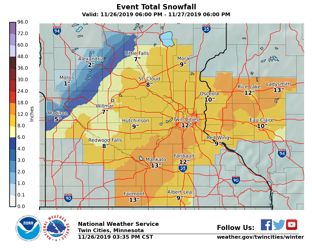
2019 may go down as one of the worst Thanksgivings for travelling in a very long time. As I sit on the south side of the Twin Cities metro area, skies are already starting to turn gray as a vast area of low pressure and some accompanying snow fall makes it’s way to the north. The latest forecast from the Twin Cities WFO calls for a foot through the heart of the metro area.
Snow has been ongoing today, particularly in northern Colorado, eastern Wyoming and across Nebraska, where it has closed schools, covered roads and severely disrupted Denver’s airport.
Since this isn’t a storm in the heart of the winter, there is the cold, snowy side, but also a side with strong to severe thunderstorms. There has already been one tornado warning in southern Missouri today, with more strong storms anticipated, particularly in eastern Arkansas.
The storm is going to continue strengthening over the next 12-24 hours, reaching maximum intensity somewhere over northern Wisconsin, meaning the snow that has fallen in the Upper Midwest will be , and the snow in Wisconsin and the Upper Peninsula will be wind driven. Altogether an unpleasant scenario. And that’s not even the worst of it.
THERE IS ANOTHER STORM.
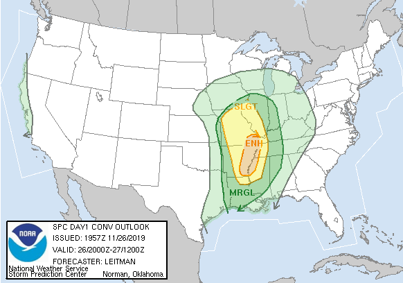
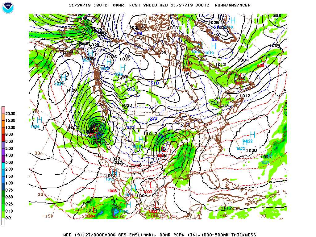
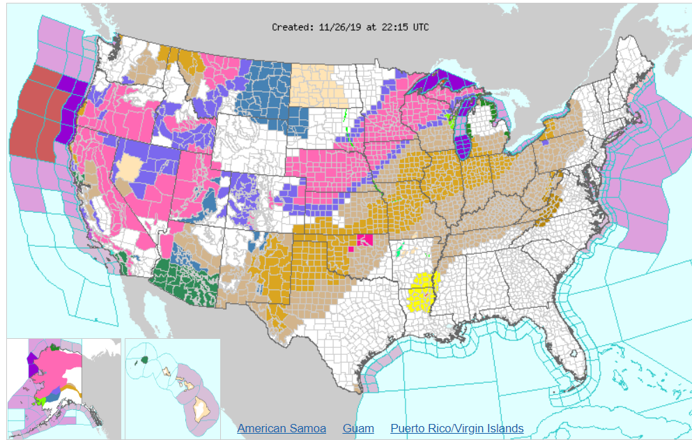
This second storm, thanks to travel across the north Pacific is in the process of explosive cyclogenesis – a bomb cyclone – and will slam into the northern California coast tonight. With it will come more gusty winds, rain and a whole lot of snow the interior west. While much of California will appreciate the rain, they could do without more wind, and the snow inland will be fairly comprehensive. That is to say, it’s not going to be confined solely to the mountains. Take a look at the watches and warnings presently plastered across the country.
All the oranges and browns are wind related alerts, thanks to the potency of the first system, while southern Arizona is also under threat for flooding, thanks to the moisture they’ve recently received, and will be reintroduced to this week.
Most of the time, foot of snow the day before Thanksgiving would be bad enough, but in the Midwest, they will also need to concern themselves with the weather after Thanksgiving. If folks somehow managed to leave the house and visit their relatives, they will then need to contend with a second round of snow that will likely start as light freezing rain, particularly from about Sioux Falls to Omaha.
In my back yard, we are probably looking at another 2-4″ of snow on top of a glaze of ice, and more gusty winds to conclude what will be a very long holiday weekend.