I’m not sure it’s happened in a while, but we get to talk about the Forecaster of the Month without having to touch on a major storm cruising through some part of the country. Of course, there is flooding rain in Bellingham, Washington today, so perhaps I should hold my tongue.
There isn’t much to say this month, except that The Weather Channel dominated the month in forecasting, winning easily over any of the competition. They hold a commanding lead for the monthly forecast titles for the year, even though they trail Weatherbug in individual forecast wins.
I’m not sure it was planned this way, but Fox Weather sure had a good chance to show off the skills it’s bullpen of meteorologists have, with a pair of severe weather days, first in Missouri on Sunday (Fox covered the aftermath on their launch day) and again in the Sabine Valley from east Texas to western Louisiana, where Lake Charles had a tornado sweep through town only a year after being devastated by the 2020 hurricane season, notably by Hurricane Laura.
That first round of storms reemerged off shore and drove into southern New England and the mid-Atlantic as a nor’easter, bringing flooding rains around the New York area. There was also more mountain snow and the long awaited conclusion of rain on the west coast, and steady rain at times for nearly everyone in the country as some point, wrought by one of these storms.
The low that was so problematic in the south central United States has become bloated and slow moving. It is now slogging through the eastern Great Lakes bringing intermittent rain to a lot of the northeastern US. Through the weekend, the low will sink off shore, become reinvigorated and blast back north into New England. Behind the feature, cooler than normal temperatures in place, and will be there for the beginning of November.
So how did Fox Weather handle the busy week? Fairly well, I would say. If nothing else, Fox Weather hired people who were comfortable in front of a camera, or were capable of highly produced television. The station is slick, and looks nice. The presenting meteorologists are clear and conversive, and it is a good over the air package.
Unfortunately, all the money was spent on making the streamed product. There is no way for you to get the forecast on their website, and the app is a challenge to use. Fox Weather is essentially a news website with a focus on the weather. You can’t get any forecasts online from Fox. Can you imagine a weather website in which you can’t get your local forecast?
There will soon be another major player in the weather market. On Monday, Fox is releasing a new streaming weather service and app. They have a weather based website primed to launch as well, but it remains unclear if that will be a traditional site, or if it will host the streaming service.
Some of the features, like the long range forecasts, are silly, and are just ways to try to drive users to the site. The 3d graphics that are promised are a selling point, and the use of local meteorologists across the country is innovative and should bring about some local knowledge that drives effective forecasting.
The elephant in the room, as with all things these days, and particularly when Fox comes up, is politics. Fox News is notoriously conservative in it’s news choices, and that has filtered down into their other media resources. Fox Sports, when they provide analysis, skews conservative as well (If you don’t believe me, listen to Clay Travis just once), and there is a thought that Fox Weather might intend the same.
I think, though, there is space in the market for an explicitly conservative weather outlet, and given the format of the app and stream, it will likely mitigate the most antediluvian tendencies. While climate change is a fairly well grounded scientific principle, it is a political issue and is not well accepted by those with conservative political leanings. While some meteorologists share these stances, they have evolved into questioning the potential impact and appropriate course of action, rather than the veracity of global warming. Additionally, with the network leaning on local weather persons, who may not be directly employed by Fox, there is probably less imperative to follow the corporate mantra.
I think the compromise that we will see at Fox Weather is that, instead of talking about climate change and mankind’s role in the process, and needing to stake a position that may or may not be different than Fox News’ position, the topic will be unaddressed. Instead, Fox Weather, to claim that conservative weather client, will focus only on shorter term forecasts and breaking weather news.
With The Weather Channel leaning heavily into climate change coverage and activism, some people in tornado alley may have drifted away. Having a resource from a brand name they trust providing the important information, they may be more keen to tune in at or ahead of time. As long as the Fox Weather personnel opt for avoidance of the climate change topic rather than being pressured into giving misinformation, I think Fox Weather has a chance to be a benefit to the public safety of our country.
If the Fox Weather site becomes usable like other weather sites we use, there is a very good chance we will see it on these pages in the future. I will also make sure to get the app and will post online any thoughts that come to mind.
We had so many forecasts this month, every outlet had at least a share of a victory. Another way to look at it is that there was good skill across the board, but that may not be 100% the truth. The victory ultimately went to an outlet that was good even when they weren’t the best, which couldn’t be said for everyone. The Weather Channel narrowly surpassed WeatherNation to gain the victory for the month. At least everyone got to feel the warmth of a victory one time in September.
Hurricane Ida made her landfall at the end of August, and continued to the eastern Seaboard to provide devastating rainfall and flash flooding before she expired at the beginning of September. Ida was an extraordinary storm, both for the strength at landfall, (and the forecast accuracy as it arrived, which definitely saved lives) and the flash flooding rains, which led to the second flash flood emergencies ever issued by the New York City office of the National Weather Service — the first was earlier in the month with Henri. It exposed the poor infrastructure of the region, which is ill equipped for torrential rains. which will only become more likely as we head into the future.
We had a lot of forecasts in the month of August, and some were impacted by the broad scope of Ida. Otherwise, heat and a break to some drought issues in the upper Midwest were the theme for the months. The Weather Channel concluded the month of August with the victory, followed closely by Weatherbug, a tandem that owns a tie at the top so far in 2021.
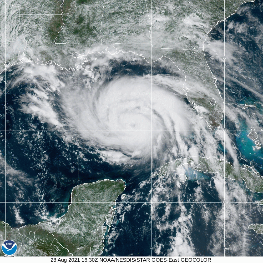
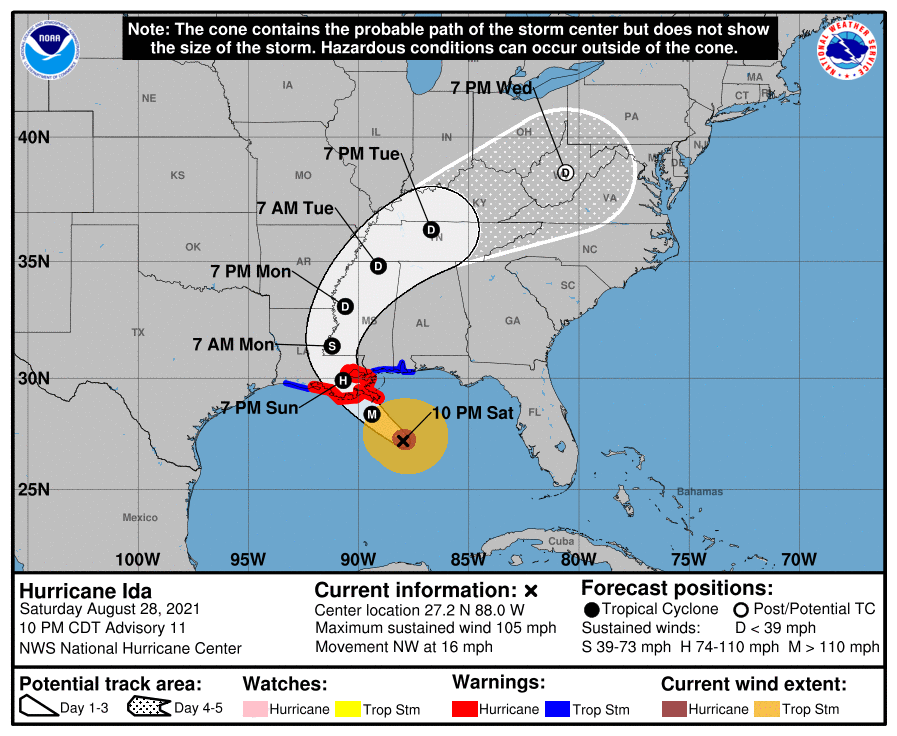
Hurricane Ida sits off the coast of Louisiana, and will descend upon the Bayou State tomorrow. Strong winds are already starting to pick up from Mobile to the Mississippi Delta. At this hour, Ida is a Category 2, but she is slowing down her momentum and is anticipated to strengthen rapidly. The NHC suggests that Ida will become a major hurricane, likely a Category 4 before she comes ashore.
Ida’s swift momentum before this point brings good news, in the fact the storm surge will not be as terrible as it could be, given it’s status as a major hurricane. The rapid development before it makes landfall also limits the fetch and the subsequent coastal flooding. Additionally, if Ida closely follows the forecast track, she will landfall south of Houma, a bayou laden, sparsely populated (relatively) stretch of coastline. This is the good news.
The bad news is that a Category 4 storm is still strong. It will pass near enough to New Orleans to cause significant problems. There will also be a disruption to the platforms in the Gulf, and a hike to gas prices nationally as a result. Also, with Ida’s recent slowdown, heavy rain and flash flooding will become a concern. The gravest concern, and what makes Ida more dangerous than most, is that because she is expected to develop so quickly, mass evacuations were not issued. There are simply far more people in the line of fire than there would be typically when a major hurricane is bearing down.
Another bit of good fortune is that Ida is a compact storm, and as a result, will not impact even the entire state of Louisiana. Where she will impact though, will struggle to recuperate. Ida will landfall tomorrow evening, and will finally pull away from Louisiana on Monday evening.
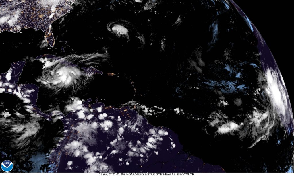
There are presently three named features in the north Atlantic and North America. Fred is continuing his slow spin into oblivion over the eastern US, while Tropical Storm Grace is moving through the Caribbean and Tropical Storm Henri is spiraling out by Bermuda. You can see them all on satllite.
Well, at least you can see the tail end of Fred. He is a spiraling storm presently threatening rain and tornadoes to the central Appalachians. The rotational energy will dissipate through tomorrow, but rain will continue in the mid-Atlantic tomorrow.
Off shore, Henri is presently the stronger storm, and likely will be the case until Grace reaches the open Gulf again. Henri will disrupt travel to and from Bermuda, but is not going to affect the island directly. Grace, the weaker seafaring storm, has never really been able to muster herself to become a hurricane, and looking at the wind history, hasn’t been a significant storm.
Of course, there are times when the numbers don’t tell all the story. Even when considering Fred, Henri is the strongest of these three storms (though Grace may eventually overtake him), and Fred has been dropping tornadoes in the western Carolinas all day, but it is indeed Grace that has been the most problematic.
Grace passed through Haiti at a time when the country was struggling with the aftermath of a strong earthquake that left thousands dead. Grace brought flooding rains to the country as relief efforts were underway. There is a point at which the death toll from the earthquake and Grace are inextricably linked, but at this point, no loss of life has been assigned to the storm. Whatever the statistics bear out, Grace, in all her disorganization came at the worst time to the worst place, something that will never describe Henri, even if he is the bigger storm.
It is absolutely a credit to the meteorological community that we are now 7 months into the year, and we still have at least 4 outlets that are legitimate contenders for the Forecaster of the year title, with a 5th not far off the pace. On the strength of a strong summer, and another winning month in July, Accuweather has ensured that they are not to be forgotten, keeping pace with Weatherbug, The Weather Channel and Victoria-Weather. The National Weather Service was second, and showed that they aren’t out of this race yet either. Congratulations to Accuweather!
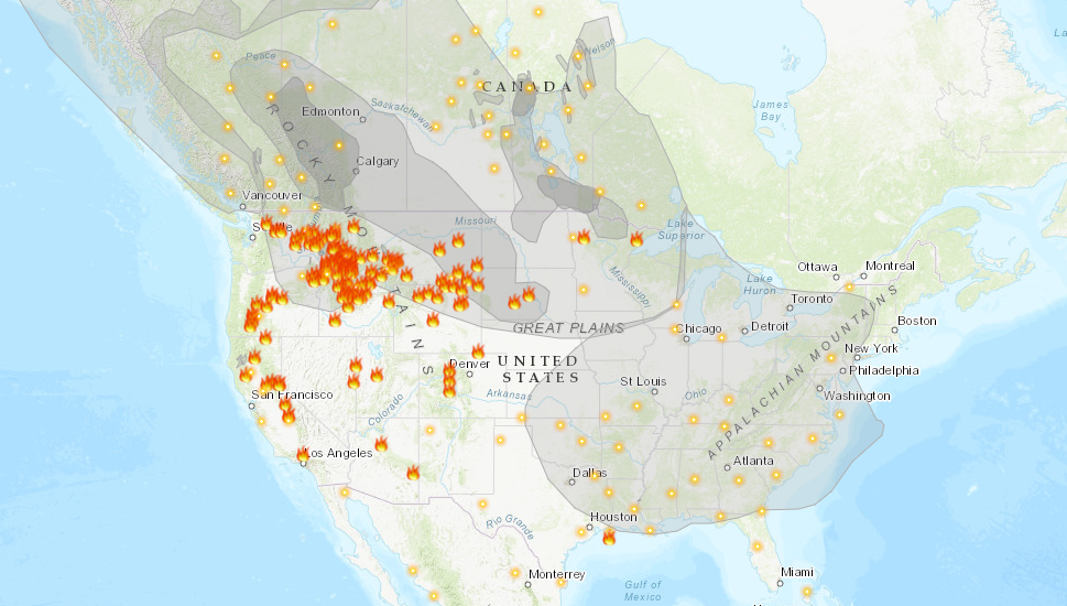
Another summer and we are plagued by wildfires. If there is any difference between this year and the last couple, it is that the bulk of the fire activity is in the northern Rockies, as well as in Alaska, rather than within the state of California. Surely, this is some relief to relatives of the Golden State, and it is definitely a good thing that the fire threat isn’t as imminent to as many people, however it is a burden for the rest of the country.
As this map, from Airnow.gov shows, there is smoke in the air for about 3/4th of the country. Air quality is below normal for all of those locations.
It is rare that the jet intercepts California during the summer, and it isn’t often that smoke can blanket the country as it is right now during a typical fire season. Also frustrating for many of the people getting smoked out right now, is that the flow bringing the smoke in is from the northwest. Were there no fires in the Pacific Northwest and particularly Alaska, the air would be cool and refreshing after a very hot month of July.
Smoke advisories continue to get extended for the region, as relief is not yet right around the corner. Fires, of course, need to be extinguished, but a more immediate source of relief would be a change in the prevailing pattern, but unfortunately, even that doesn’t look to change until at least late in the week.
In many summers, I find myself rolling my eyes at other outlets’ analyses of the surface. There is often a stationary boundary, left for days along the Gulf Coast of the US. Perhaps a cold front had descended from the Ohio Valley a week prior, but eventually, you need to call a spade a spade. There is onshore flow, and it causes thunderstorms. Not every boundary is a cold front.
This year, and especially right now, we haven’t been seeing those straggler boundaries populating the coast. Right now, it’s evident that there is an off shore boundary pointing into the Carolinas
One might be inclined to analyze something along the band of thunderstorms through north Florida, or perhaps even further north on the clearing line from southern Kentucky to central Oklahoma. In fact, most outlets are keeping truncated fronts, and there is a very good reason for that.
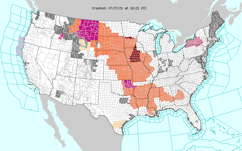
All of those orange and red shades are heat advisories. It is astonishingly hot throughout the Plains and Mississippi Valley. It’s really hard to say there is a cold front when there is a heat wave immediately behind the boundary. The WPC, proponent of the long ranging front, parlays the cold front into a warm front hugging those advisories to the west.
The jet is still somewhat active, but it remains well north of the domestic US. A cooler start to July in the southeast and a blistering start in the north is also starting to level off, but is making for a challenging environment for cold fronts to survive. If a change occurs, it will have to come from the west, which may happen next week.