
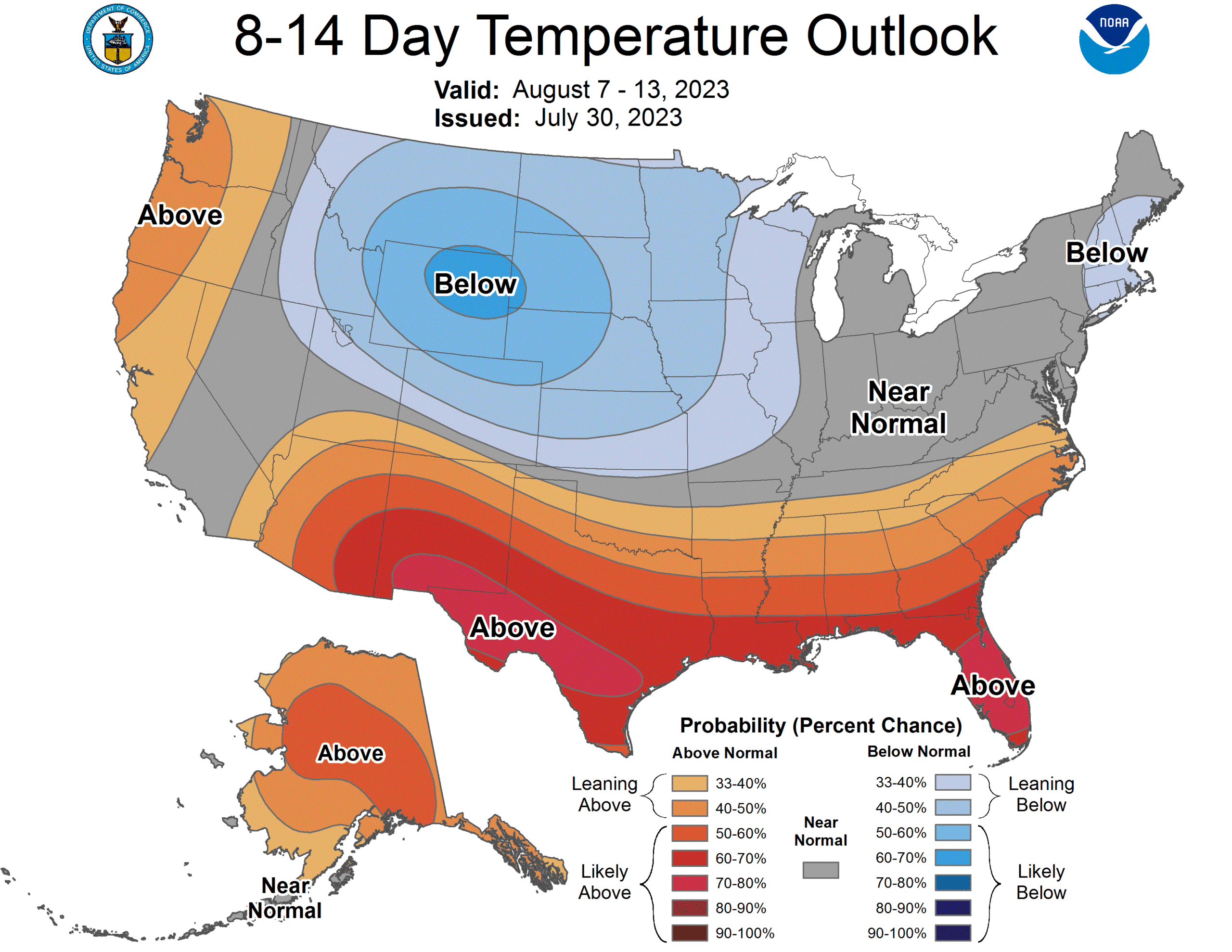
This is a bit of a long range out look, and it is pretty specific to the northeastern corner of the country. It’s pretty warm in New England, down through the Mid-Atlantic, and with a stalled trough over the Great Lakes, that warmth is going to continue building up into the northeastern US for several more days. According to the long term outlooks for the rest of the month, however, things will be about normal as far south as DC. Fingers crossed that means a pretty cool end of the month?
Orlando, Florida
We’re setting forth for Orlando for our forecast today, home, as you all know, to many of the nation’s largest tourist venues. Florida can be unbearable this time of year, but it’s still summer, and people need vacations!
At 753PM, ET, Orlando was reporting a temperature of 85 degrees with clear skies. Thunderstorm activity is starting to peter out as the sun goes down, but is expected to reemerge in the morning. Sea breezes are the primary instigator for thunderstorm activity lately in Florida. The trade winds are stronger than the Gulf breeze, and the storms, as today, have been drifting west towards the Gulf through the day.
The pattern in the southeast is pretty stable. There is a trough in the north east with weak flow through it and a ridge in the Plains. Tropical intrigue has been further north than is typical this early in the season, and the weak trough is enough to have driven activity up into the North Atlantic. Trade activity is expected to remain the only significant pattern in Florida, with isolated thunderstorms tomorrow and Saturday in Orlando. A surface trough meandering into Georgia may invigorate the diurnal thunderstorms
Tomorrow – Isolated thunderstorms, High 94, Low 73
Saturday – Scattered showers with isolated thunderstorms, High 94, Low 74
TWC: Tomorrow – Sunshine and some clouds. A stray shower or thunderstorm is possible High 94, Low 75
Saturday – Scattered showers and thunderstorms. High 90, Low 77
AW: Tomorrow – Sunshine mixing with some clouds with a thunderstorm in the afternoon High 93, Low 75
Saturday – Sun and areas of high clouds in the morning followed by considerable cloudiness with a stray thunderstorm High 95, Low 77
NWS: A 30 percent chance of showers and thunderstorms after 2pm. High 93, Low 74
Saturday – Showers likely and possibly a thunderstorm. Mostly sunny, High 93, Low 77
WB: Tomorrow – Partly sunny. A chance of afternoon showers and thunderstorms, High 91, Low 78
Saturday – Partly sunny with showers likely and chance of thunderstorms, High 90, Low 78
WN: Tomorrow – Partly cloudy with chance of storms, High 93, Low 74
Saturday – Partly cloudy with showers and chance of storms, High 93, Low 77
CLI: Tomorrow – Light rain showers High 92, Low 76
Saturday – Thunderstorm High 91, Low 77
Summer time in Florida. Thunder and lightning just go with the territory. At least the tropics aren’t quite threatening yet.
Mea Culpa
I certainly thought that today, at the very least, would be the last day for showers and storms in the mid-Atlantic. If I am being fully honest, I will admit that I kind of thought yesterday would be that day. Instead, there is just the barest threat for showers and storms even tomorrow.
EDIT:
I guess I will note that the precipitation threat is gone tomorrow between Cumberland and Louisville. I was close, just used the wrong forecast.
Coming Soon…
August is right around the corner – tomorrow, actually – and we are going to dive right into hurricane season. What does the forecast plan look like as all eyes turn to the north Atlantic?
Syracuse, New York
Trenton, New Jersey
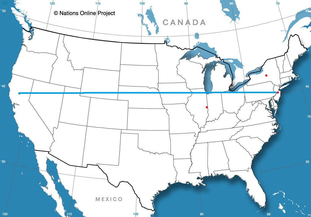
Road trip from Yuba City, California to Trenton
Danville, Illinois
Road Trip Update
I know the forecast is long expired now, but the road trip forecast I published last night looks good. The light bands of showers through the Mountaineer State are continuing at this hour, but there is no thunder activity, and it isn’t very heavy. Post frontal, but still northerly flow from a strong area of low pressure.
Almost there
Sorry to the deep south though, I guess the cool down is still way out.
Get used to this.
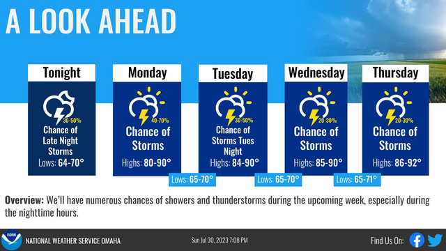
The thing about summer is that patterns get slow and sluggish, less dynamic. A cold front has sagged into the middle of the Ohio Valley and is connected with a stationary front through Montana. Not strong, not moving much, but present, which will mean isolated storms within a couple hundred miles o the boundary. Not strong, but not moving, either. Enjoy this active forecast, Omaha (courtesy the NWS)
Louisville, Kentucky to Cumberland, Maryland
All right, let’s take a trip! It’s only going to be a 7 hour trip through the mountains of eastern Kentucky and West Virginia between our two end points on this Sunday journey. I can definitely say that these 472 miles would have been a lot more interesting today or yesterday, but alas, we try to avoid thunderstorms when driving.
Low pressure has really figured itself out in the Gulf Stream, and the cold front associated with it left a healthy stripe of wind damage reports from the Delmarva to the Smokey Mountains. Already today, the heaviest weather has remained south of our route, and northerly flow will remain in place on Sunday over the area surrounding West Virginia. The feature is strong enough, and the atmosphere is rich enough that there might be a few stray showers riding those north winds as we head towards western Maryland, but the most pleasant weather the region has seen in a while with only passing clouds will define the majority of the day.

Cumberland, Maryland
Hello, and good evening, I hope you weren’t up waiting fore this late night forecast. It’s here anyway.
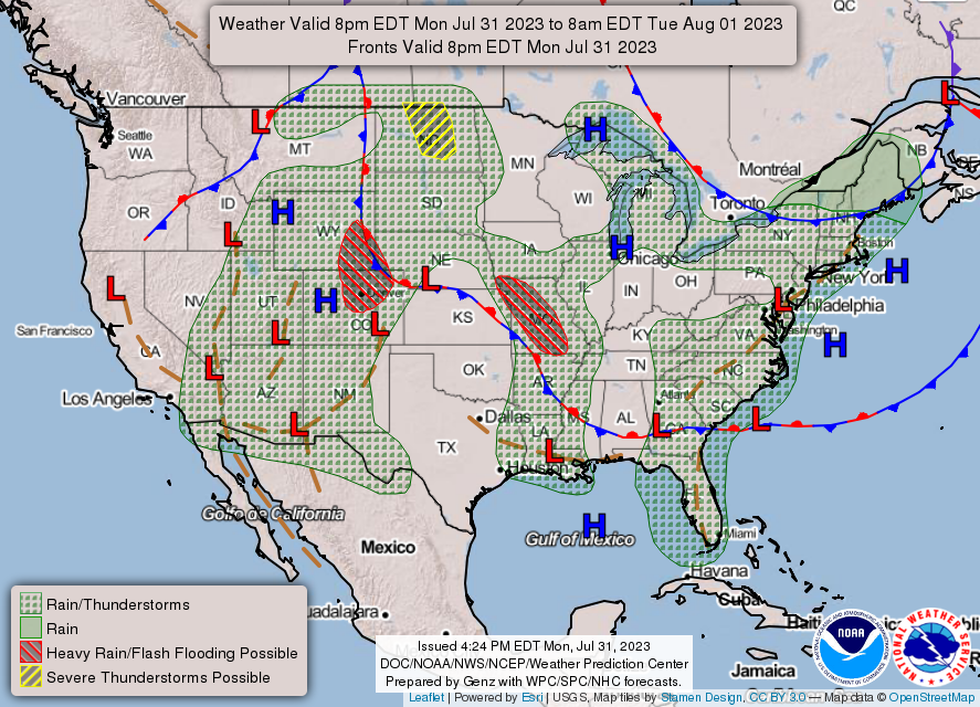
At 1253AM, ET, Cumberland was reporting a temperature of 78 degrees with clear skies. Cumberland was lucky to evade a round of very heavy thunderstorms earlier today, which brought strong winds to West Virginia and northern Virginia, as well as parts of eastern Maryland, but left western Maryland unencumbered. All these storms have been running along a slow moving cold front that is expected to start to resemble a continuous bowing cold front, running from the Chesapeake to the Mid-Mississippi Valley.
The thunderstorms along the boundary will start to organize it’s southward march by tomorrow afternoon. There is a mass of thunderstorms presently moving eastward in the southern Great Lakes that will be ongoing through the morning, and may delay the southerly turn a bit. The change in direction and redevelopment of activity will likely limit the potential severity of thunderstorms on Saturday for Cumberland, though a gust of wind or hail could be seen in the mid afternoon. Cold – relative to what has been seen – air will press in to make Sunday a satisfying conclusion to the weekend.
Tomorrow – Scattered showers and thunderstorms, a threat for severe storms, High 90, Low 69
Sunday – Mostly sunny, High 86, Low 65
TWC: Tomorrow – Thunderstorms likely in the morning. Then a chance of scattered thunderstorms in the afternoon. Gusty winds and small hail are possible High 89, Low 71
Sunday – Sunshine and clouds mixed. A stray shower or thunderstorm is possible. High 86, Low 67
AW: Tomorrow – Mostly cloudy and humid with a shower and thunderstorm; thunderstorms can bring flash flooding and localized damaging wind gusts High 90, Low 70
Sunday – Less humid with intervals of clouds and sun High 87, Low 69
NWS: Tomorrow – Scattered showers and thunderstorms before 8am, then scattered showers between 8am and 11am, then scattered showers and thunderstorms after 11am. Partly sunny, High 91, Low 71
Sunday – Isolated showers and thunderstorms. Mostly sunny, High 85, Low 67
WB: Tomorrow – Partly sunny with scattered showers. Isolated thunderstorms in the morning then scattered thunderstorms in the afternoon. High 86, Low 72
Sunday – Partly sunny in the morning then clearing, High 82, Low 70
WN: Tomorrow – Partly cloudy with scattered storms, High 91, Low 72
Sunday – Partly cloudy with isolated storms, High 85, Low 67
CLI: Tomorrow – Light rain showers, High 91, Low 70
Sunday – Sunny, High 86, Low 70
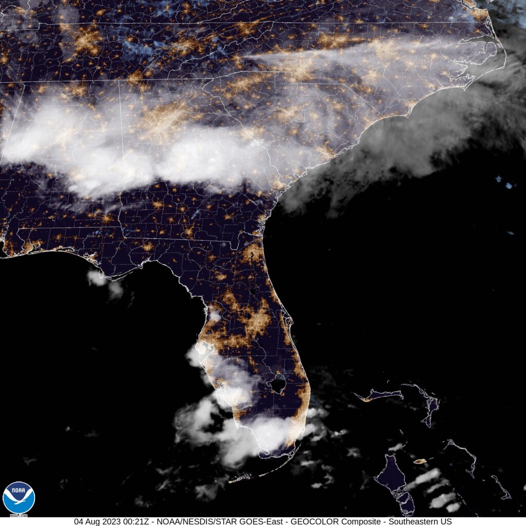
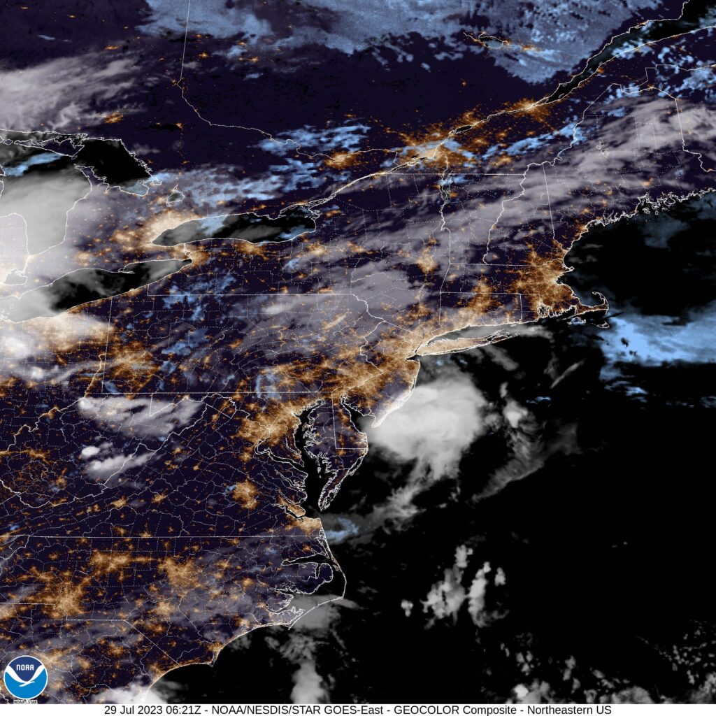
Some overnight imagery. Thunderstorms in Pennsylvania have tapered off, so not much to impress at this late hour.
Expect August to be dominated by two different stories. The continuing heat, which has lead to extreme warmth in the north Atlantic, and the approach of peak hurricane season. All other things being equal, you might expect that the increased sea surface temperature would lead to an increased risk for hurricane development. There is a long way to go and it certainly remains to be seen, but at this point, it’s still pretty quiet out there.
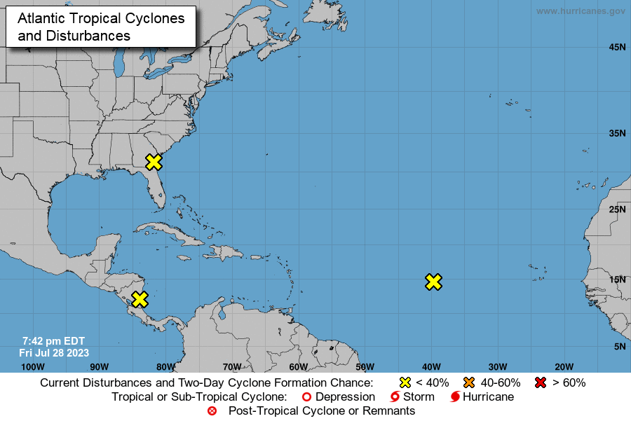
Of course, while it feels like a slow season, the next named storm will already be the 5th of the year.