Did you know the slogan for high surf put forth by the NWS?
“When in doubt, don’t go out”. Now you know.
from Victoria-Weather

Did you know the slogan for high surf put forth by the NWS?
“When in doubt, don’t go out”. Now you know.
I noted the storm getting ready to move into New England over the next 48 hours, but what I didn’t note was that interior New England is one of the few places across the country that already has snow on the ground. If you want snow, you had better also have a mountain or an upwind Great Lake.
Another note to the storm headed to New England… The element that is supposed to be introducing the cold air isn’t even cold enough for snow in Michigan. Rain is expected overnight through much of lower Michigan
It’s been a pretty warm start to the winter, but a classically set up nor’easter is headed for New England tomorrow and Monday. There is the strong area of low pressure able to tap into Gulf Moisture, and attached occluded low bringing in colder air. Voila, you have the ingredients for a snow storm.
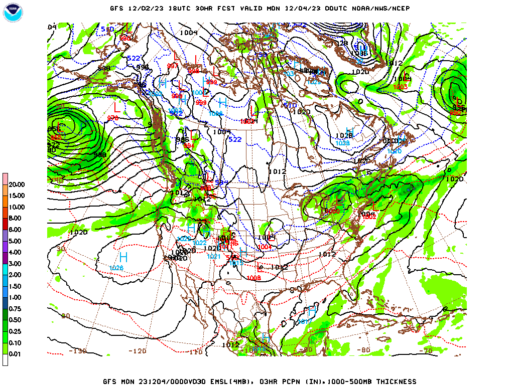
There is one thing that is not there though – enough cold air already in place. Because of the lack of chill to the air, the snow will fall abundantly, but is not going to make it to the coast.
Even if this isn’t going to be an impactful event for the largest population centers, it will certainly be a pretty good bit of news for snowmobilers and ski resorts in the area.
In the transitional seasons, air masses are much more different from one another. Cold air is significantly colder than the air it replaces in the spring and fall, and not as much in the summer or winter. And because the sun angle is lower, having a few clouds can really affect the temperature more than they might in the summer. All this is to say is in the fall, you had better have your timing right. In Monroe, Michigan last month, the timing for a wave moving through as a little off. Clouds filtered in on Sunday the 19th early in the day and suppressed high temperatures. A system rising from the south central US was moving more quickly than expected, and brought not only rain but a warm front that meant temperatures ended up warmer than anticipated. All in all, it wasn’t a well spotted forecast for anyone, but Accuweather had the best temperature forecast and was one of the outlets that correctly had rain on Monday.
Actuals: Sunday, November 20th, High 44, Low 34
Monday, November 21st, .32″ of rain, High 49, Low 39
Grade: C-D
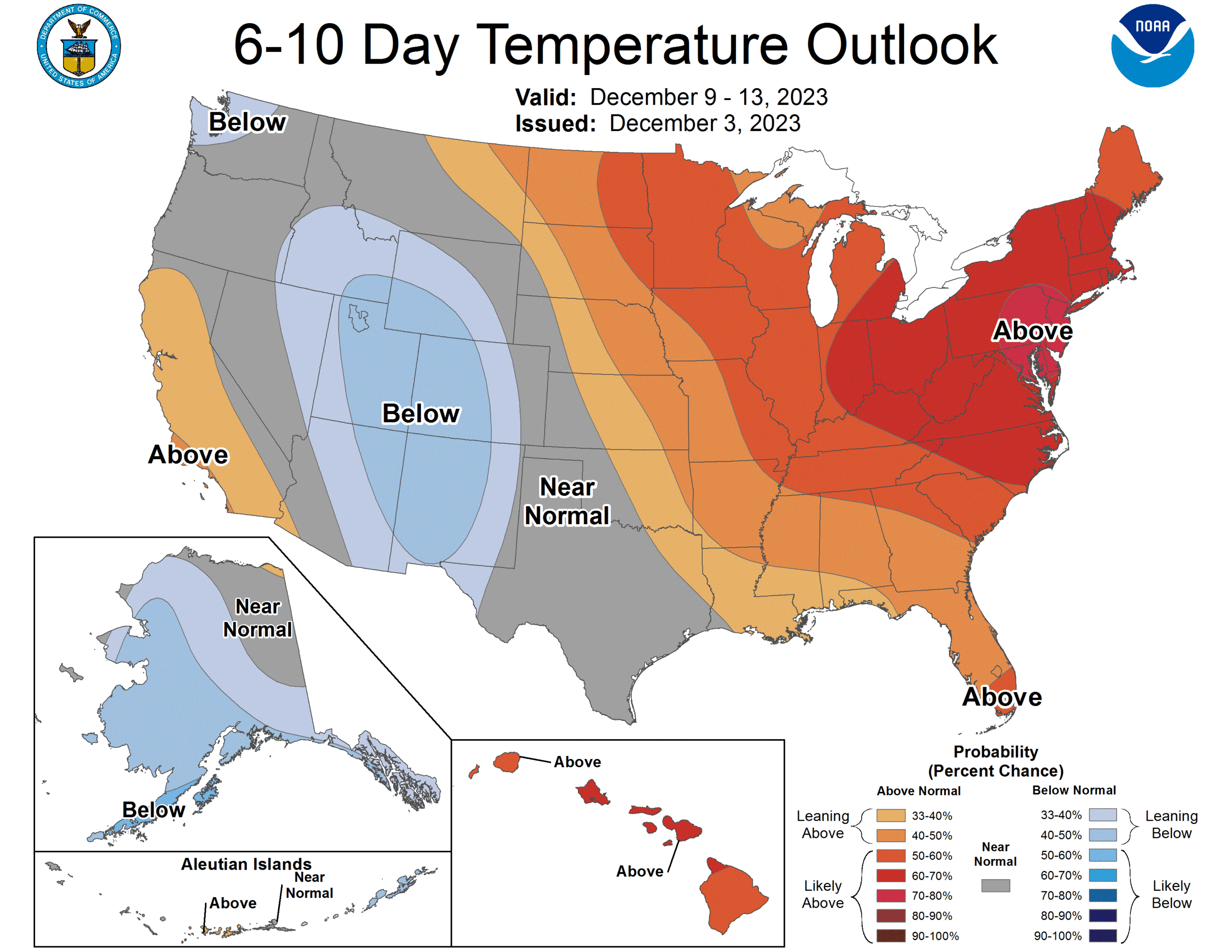
We’ve had a pattern lately with the subtropical and polar jet were seen in the Continental US, but now, there is only one strong jet rising and falling through the country. Instead of winter weather, though, it is bringing a strong ridge in from the west coast, which is going to lead to a pretty warm middle of December.

A look at the Aviation Weather page shows a lot of red and purple dots, which means IFR and Low IFR conditions. These conditions are tied to low visibility or low clouds, that make landing difficult without instruments (that is what the I stands for). A look at the satellite imagery would show that this has less to do with clouds, and more to do with widespread fog, giving us a gray and dismal start for the weekend to a lot of people.
It’s that time of year for the Great Lakes. The Lakes haven’t yet iced over, but it’s still fairly chilly. There is a weak wave moving through the region, which means that it will be streaming cold air over the warm water, and it’s just going to keep snowing. It’s not really the western New York, multiple feet of snow kind of Lake Effect, just a persistent flurry that won’t go away. No thank you!
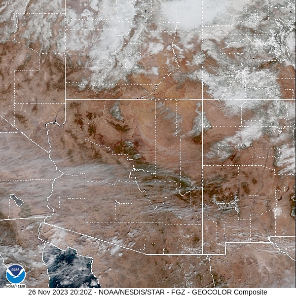
Northern Arizona has weather that is more akin to the Rockies, which makes it a more palatable destination for people visiting the Grand Canyon. Flagstaff is a lot more palatable than some people think when they hear “Arizona”. It would be a real shock to hit 110 in Flagstaff.
At 157PM, PT, Flagstaff was reporting a temperature of 39 degrees with clear skies. An upper level trough was tailed east to west from the central Plains towards the Great Basin. Unlike tilted troughs normally behave, this will shove off to the east overnight, with high pressure building into the western US.
The high pressure in the region will allow temperatures to warm up a bit. The subtropical jet will still run through northern Mexico, so summer like temperatures are not going to return to Arizona, with only a few fair clouds for Flagstaff.
Tomorrow – Partly cloudy, High 42, Low 19
Tuesday – Fair skies, High 48, Low 18
TWC: Tomorrow – Cloudy. High 42, Low 19
Tuesday – Sunshine and clouds mixed. High 47, Low 19
AW: Tomorrow – Partly sunny and chilly High 41, Low 21
Tuesday – Partly sunny High 47, Low 17
NWS: Tomorrow – Mostly cloudy, High 43, Low 16
Tuesday – Sunny, High 47, Low 16
WB: Tomorrow – Mostly cloudy, High 40, Low 23
Tuesday – Mostly sunny, High 46, Low 21
WN: Tomorrow – Mostly cloudy, High 43, Low 17
Tuesday – Mostly sunny, High 47, Low 18
CLI: Tomorrow – Overcast, High 40, Low 20
Tuesday – Sunny, High 45, Low 20
Some diversity to the temperature forecasts, which is nice, and makes sense. Like I said, northern Arizona is very much like the Rockies, which are mercurial at their best. Satellite shows some streaming clouds in southern Arizona, and more congested clouds north of the border.
Snow totals in the mountains were less than one might expect for typical weather advisories. Sure, in the tallest peaks it piled up, but even at some of the resorts, there were only 3-5″ of snow, less on the heavily travelled corridors. Hopefully that means everyone did their holiday traveling safely.