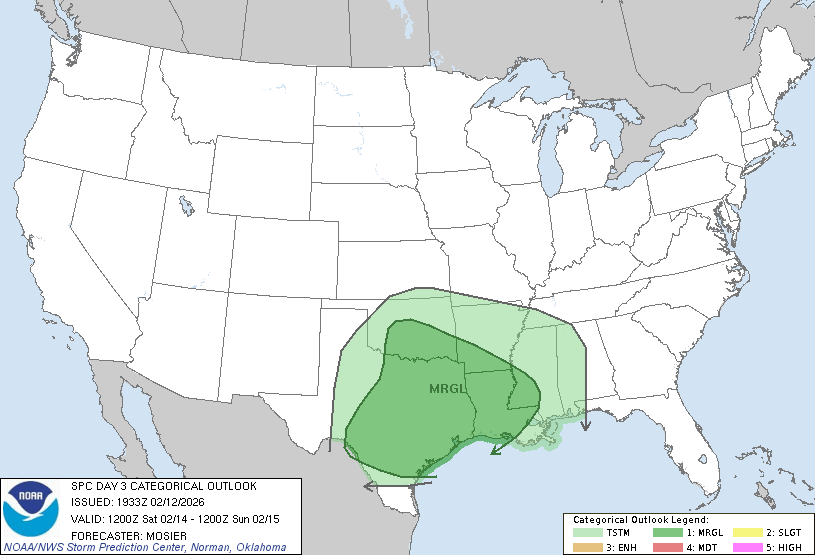
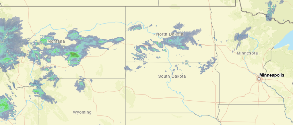
10:28PM: We talked about the change the pattern is going to be experiencing in the very short term. One of the functions of this change is that we will see an active pattern, with low pressure drawing moisture out of the Gulf. Well, here it comes. This is the thunderstorm outlook for Saturday.
It’s been a brutal winter for the eastern part of the US, particularly in the southeast. Temperatures have been colder than normal, and there have been historic ice storms. Parts of the country have endured subzero temperatures for long stretches, while further south, even as far as central Florida, temperatures were, at times, below freezing. No longer!
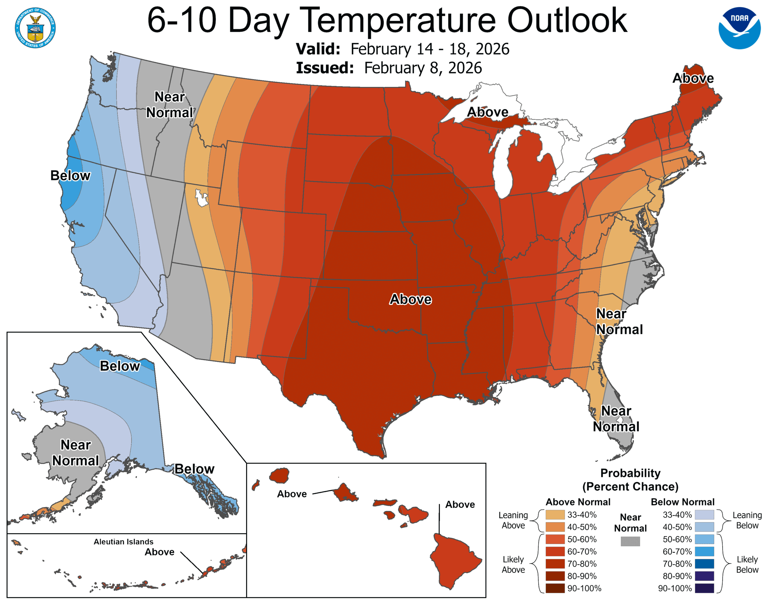
The trough that has been in place over the eastern US, the lobe of the polar vortex that has made everyone so uncomfortable is now back up in the Arctic where it belongs, and a warmer batch of high pressure is moving into the middle of the country. Temperatures are warming up, first in the Plains, but eventually through the Great Lakes, Tennessee Valley and on to the East Coast.
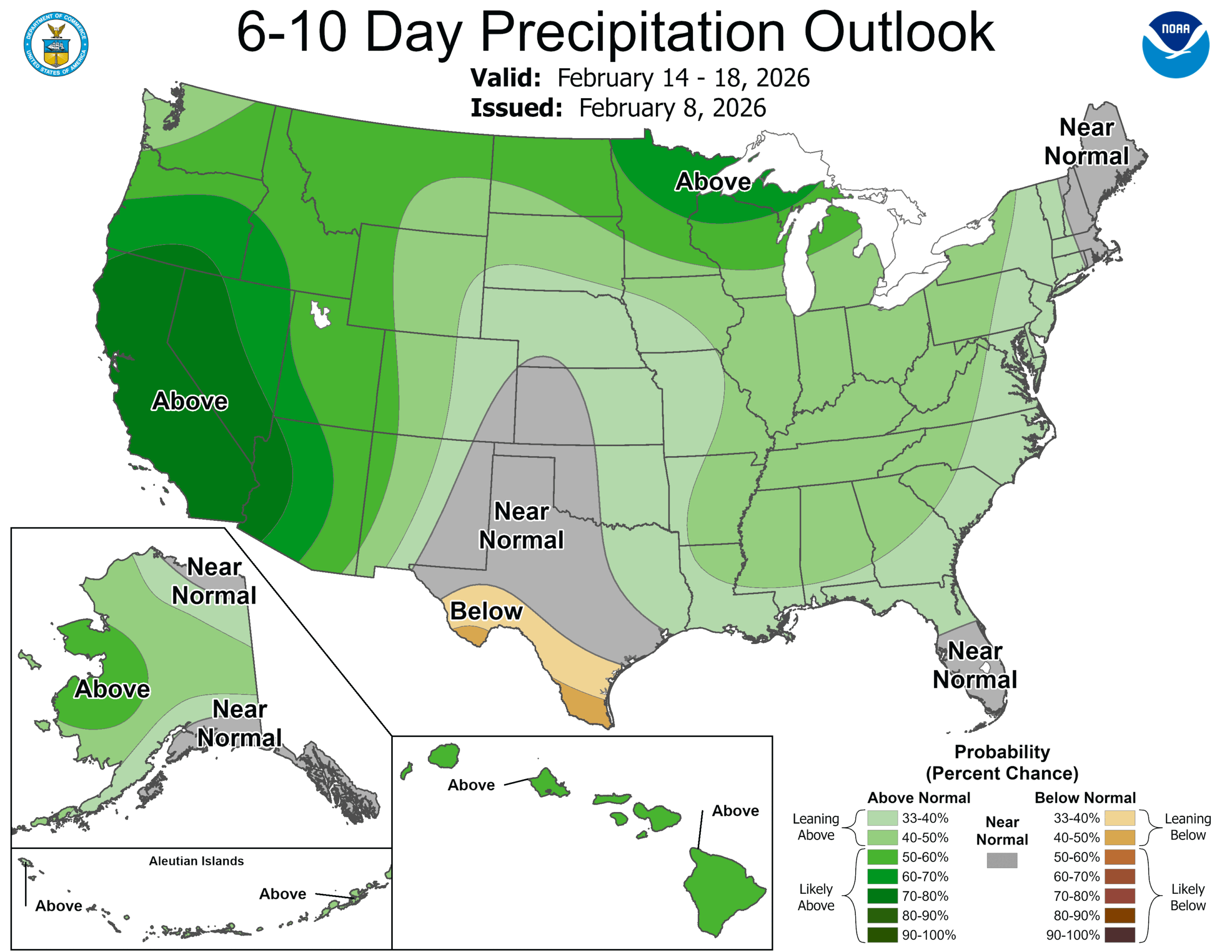
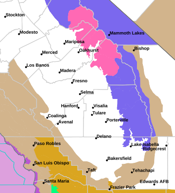
We haven’t talked much about the West Coast, save for more normal conditions and some persistent rain earlier in the winter. The precipitation was intense at times, but more recently it has been dry and warm, just like we have grown to expect along the Pacific for the past few years. The early season rain has tamped down the concerns, and guess what? The early season rain looks like it will be late season rain as well.
In the very near future, the movement off of the persistent eastern trough is allowing generally more activity through the lower 48. Pattern movement means precipitation, as it will nationwide next week, but also, systems east of the Rockies will draw their energy from the Gulf and points southward. This is early for this sort of pattern, which means above normal temperatures for about 4/5ths of the country.
Of course, the active pattern will begin out on the West Coast, with rounds battering California before moving into the Plains, where low pressure will deepen and cause the increasing warm air and action discussed in the previous paragraph. The temperature trends are swapping coasts, and along with it, expect a stormy time ahead.
11:33PM: I hope everyone enjoyed the big game! If you are taking a quick gander at the radar before bed, the only thing that stands out to me is that a boundary in the northern Plains is spitting out a bit more snow than I think we expected. Otherwise, a pretty quiet night elsewhere. Except Seattle, I assume.
10:52AM: I can confirm from our forecast for Janesville last night that a weak little band of snow did come through, but there were no accumulations noted. There were light snow showers in the observations for about 3 hours, and now it is 36. It is cloudy, so don’t get ready to go tanning or anything quite yet.
12:57PM: The weather is quiet for a lot of the US right now, but there is one pocket of the nation that is looking ahead to a bit of snow. It is a very narrow pocket, and it isn’t much snow, though. This one is for the handful of people that might actually visit this site!
Janesville is on the Illinois border, just north of Beloit. I know it best as a constant source of road construction, seemingly every time I attempted to drive between my parents’ in Minnesota and school in Indiana.
At 245PM, CT, Janesville was reporting a temperature of 34 degrees with overcast skies. An undercutting boundary beneath strong low pressure in western Ontario was found at the back edge of the local overcast, and at the leading edge of advancing warm air. That boundary was over central Iowa, however, and the warmest push of air is not expected to make it to Janesville before nightfall, and a weak cold front will arrive to chase it out by sunrise tomorrow. The boundary will be quick moving, and bring just a dusting of snow through the morning, with clearing skies coming by afternoon. The clearing trend will continue with high pressure developing in the western Great Lakes. The clear skies will still feature some brisk northwest winds, but warmer weather is not far behind this forecast period. Tomorrow – Early snow flurries, then clearing, High 36, Low 12 Saturday – Mostly sunny, High 20, Low 5
TWC: Tomorrow – Cloudy early then partly cloudy and windy later in the day. A few flurries or snow showers possible High 36, Low 16 Saturday – Mostly sunny early then increasing cloudiness later in the day High 25, Low 7
AW: Tomorrow – A couple of flurries early in the morning; otherwise, mostly cloudy and breezy; watch for slippery spots early High 36, Low 14 Saturday – Turning cloudy and cold High 22, Low 4
NWS: Tomorrow – A 50 percent chance of snow, mainly before 8am. Cloudy, then gradually becoming mostly sunny, High 34, Low 14 Saturday-Increasing clouds, High 21, Low 5
WB: Tomorrow – Cloudy with chance of light snow in the morning then mostly cloudy with scattered flurries in the late morning and early afternoon. Partly sunny late in the afternoon High 36, Low 14 Saturday – Colder. Sunny in the morning then becoming partly sunny. High 22, Low 6
WN: Tomorrow – Mostly cloudy with scattered snow showers, High 35, Low 14 Saturday – Partly cloudy with snow showers, High 21, Low 5
CLI: Tomorrow – Heavy Snow showers, High 37, Low 10 Saturday – Mostly cloudy, High 21, Low 4
Hang in there, Janesville! The snow is a set back, but warmer weather is coming next week!
We are off on another trek, this time lasting a day and a half, covering 884 miles. The first day will be the full day, and will conclude after about 532 miles. The pacing on this trip will be 66.5mph, which is pretty good! Let’s hope for dry roads!
DAY ONE (Monday)
Gadsden, Alabama
The weather is clear now, what with our cavalcade of wintry weather finally clearing out of the southeastern US. The interstates are getting cleared first, but the beginning of our drive, through hard hit Tennessee, specifically Nashville, which is still trying to thaw. It’s snow in Kentucky and southern Illinois, but that is a lot easier to push to the side of the road. Our drive will end in Wentzville, Missouri, a western suburb of St. Louis.
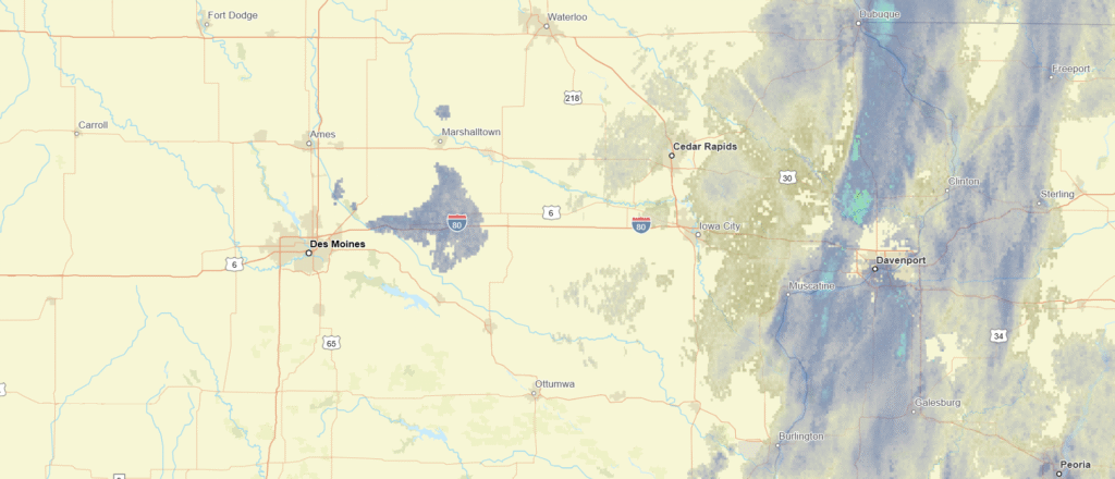
DAY TWO (Tuesday) Behind the ridge that is bringing the pleasant weather to the Mississippi Valley is the next upper level trough, which I need to assure you is not like the last two. Nevertheless, some precipitation will be coming together as we get started on Tuesday morning. There may be a few flurries between Wentzville and Hannibal, but it certainly isn’t an all day affair for us, driving into Ames, which will be at least warmer than it has been.
We’ve spent a great deal of our time and energy focused on the southeastern US, so we get to get a taste of something different this evening.
At 453PM, CT, Ames was reporting a temperature of 32 degrees with overcast skies. This is following a band of light snow that was related to a clipper moving through the Upper Midwest. An area of high pressure is moving through the Canadian Prairies, with a bit warmer air flowing under the upper level feature. The Canadian ridge will sink back to the south tomorrow, and there is a chance for a band of flurries Late tomorrow, but the advancing area of high pressure will ensure that the day won’t be completely snobound. Tomorrow – Increasing clouds with late flurries, High 31, Low 16 Tuesday – Mostly sunny,High 25, Low 14
TWC: Tomorrow – A mix of clouds and sun early, then becoming cloudy later High 31, Low 20 Tuesday – Partly cloudy. High 28, Low 18
AW: Tomorrow – Intervals of clouds and sun High 30, Low 18 Tuesday – Periods of clouds and sunshine High 26, Low 17
NWS: Tomorrow – Partly sunny, High 30. Low 17 Tuesday – Partly sunny, High 28, Low 17
WB: Tomorrow – Partly sunny. High 31, Low 22 Tuesday – Partly sunny. High 26, Low 18
WN: Tomorrow – Partly Cloudy, High 29, Low 17 Tuesday – Partly Cloudy, High 28, Low 16
CLI: Tomorrow – Overcast, High 33, Low 17 Tuesday – Mostly cloudy, High 28, Low 10
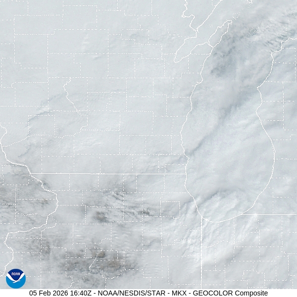
Here’s the radar imagery for Iowa, with our warm front already through town. Well, through the Hawkeye State, actually.
We are taking a one day trip, but it is going to be a slog through part of the world that has been the focus of wintry conditions this season. I can’t imagine that this bodes well for the journey. It is presently allotted for about 8 hours and 525 miles, covering 65.8mph. I hope. We just have to try to trust the local DOTs.
Fantastic news for anyone looking to travel in the Southeast: no new precipitation is expected for that particular stretch of land. Unfortunately, it won’t be getting any warmer, either. The chilly conditions, on top of a half foot of snow, in a part of the world that doesn’t get a chance to plow very often suggests that whatever snow fell over the last couple of days is probably still going to be there. The snow had a difficult time clambering over the higher terrain in the Appalachians, There is at least light snow as far to the west as Atlanta, where the eastern suburbs still have an inch or two on the ground. Fortunately, the roads will dry up to conclude the dry. Expect some tentative drivers joining the road with increasingly impatient drivers. The traffic should start to wind down for that last drive. Maybe then we can appreciate all that sunshine.