There have been plenty of, and will continue to be plenty of, storms for the spring. This weekend will be highlighted by snow and severe weather. Behind that? Historic warmth.
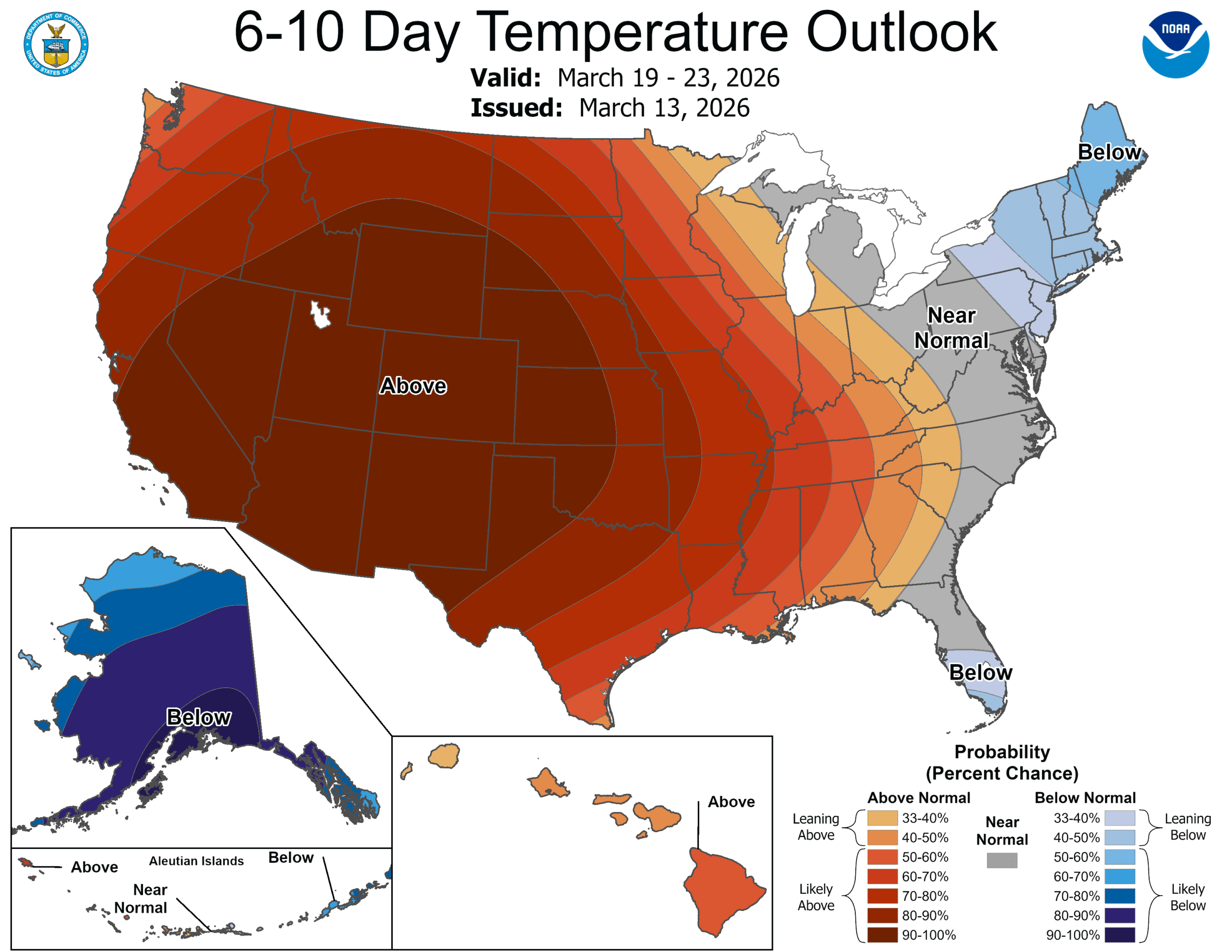
A double round of hot weather is coming for the western US, and will end ski season and all the good vibes of a healthy winter of moisture. We aren’t just talking a little warm, either. By the middle of next week, places like St. George, Utah could see triple digits. On St. Patrick’s Day!
A strong, standing ridge will arc over the western Continental US. Despite a good system in the Gulf of Alaska, the hot high pressure is going to be stuck in. The jet will eventually weaken, but not necessarily move. The heat may wear off as March wears on, but it will not ever fully go away, not for a while, anyhow.
The real hazard will ultimately come from the strength of the surface ridge, and whether or not Santa Ana winds compound things in Southern California.
And yes, between the last two posts here, it’s been a real roller coaster.
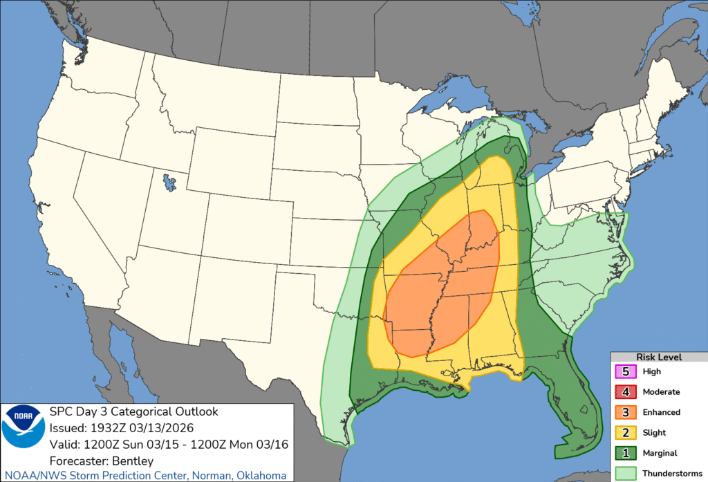
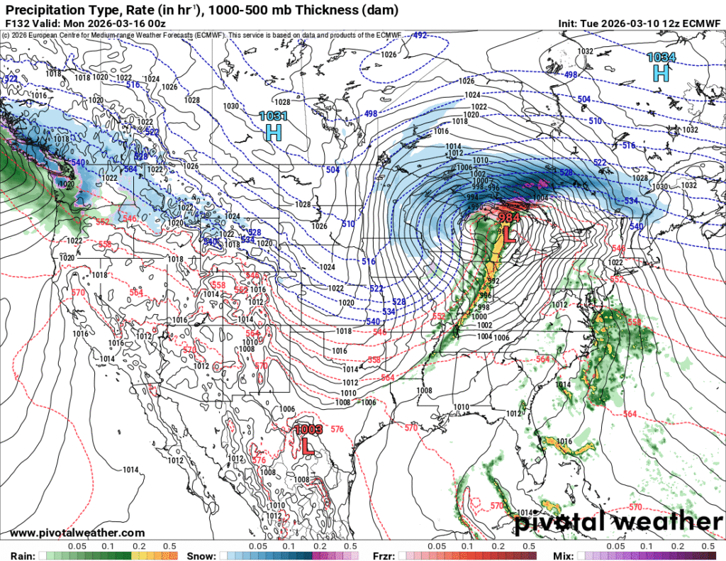
10:15PM: Here in Minnesota, we’re worried primarily about the overwhelming amount of snow and ice that is coming our way. As I noted, however, we’ve got a jump on the severe weather season as well for many parts of the country. The more traditional March storm zone will get it on Sunday. It will be a good day to remain vigilant in the Mississippi Valley, east to the Tennessee Valley.
There was another deadly tornado event in the Great Lakes area on Tuesday. This time, a pair of tornadoes struck south of Chicago, near Kankakee and across the border in Lake Village, Indiana, where two were killed. Local authorities said that, where it not for advanced warnings before the storms struck. The weather impact will not be as further to the northwest over the next 72 hours, but also, we will be absent the forecast certainty.
I’m sorry? What? WHAT?!
It has already started this evening in Minnesota, and this weekend will be…. something?
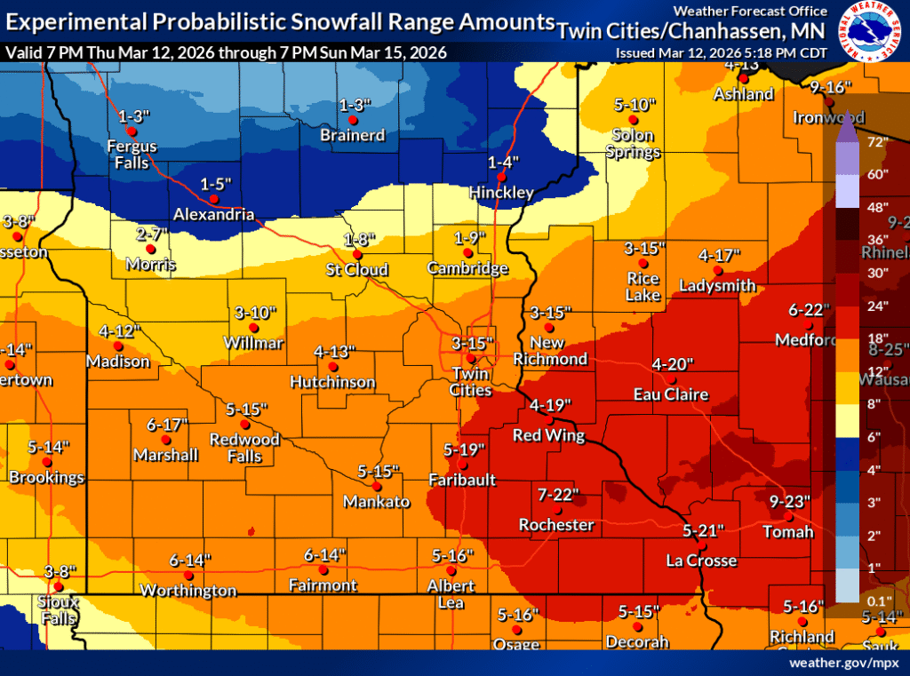
The National Weather Service has a feature in which you can see the percentage chance of getting over a certain accumulation level. In the Twin Cities, the chance of getting over 4″ is 71%, over 6″ it is 56%, but then over 8″ it is 46% and over a foot is 35%. If it snows over a few inches, Twin Citians may as well plan on a foot.
That’s no way to go through life!
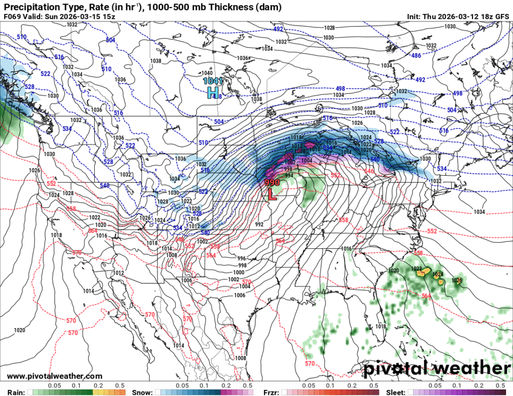
There is a system moving into the Great Lakes tonight, and a stalled boundary that will linger in the region tomorrow, and a warm front that will fill in on Saturday. The real show will come on Sunday.
One way or another, that’s a lot of precipitation inbound. The uncertainty lies with the temperature profile, for one thing, and exactly where that heaviest band of precipitation will set itself up. I wouldn’t be surprised if there is a band maybe 20 miles wide that clears a foot and a half of snow, with the accumulation falling off significantly on either side of that band.
That’s probably the hedge that the NWS is also leaning on, and it will be tough to determine where that heavy band is going to set up, until it sets up.
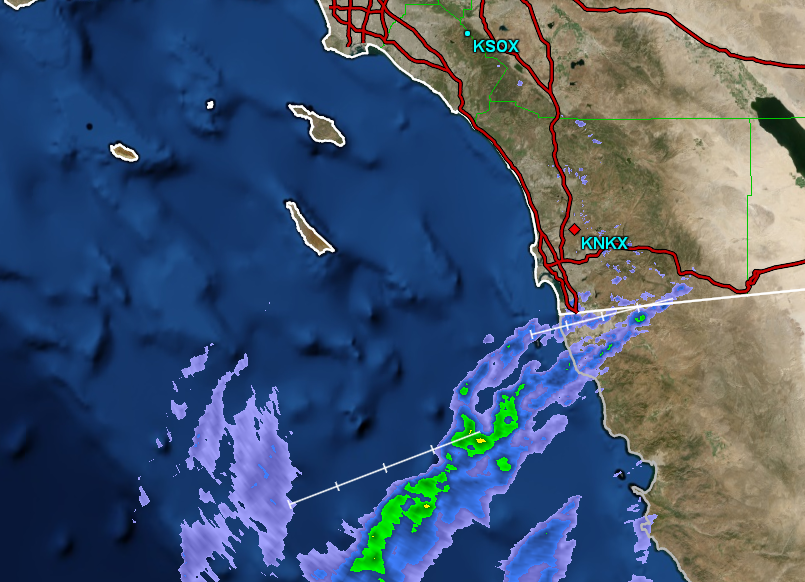
Between the uncharacteristic rains earlier in the year, but before the heat settled in to this part of the world, we took a trip to San Diego. The forecast was issued at just the right time, to capture postcard perfect weather. At the end of February and beginning of March, temperatures were starting to creep up there, which meant outlets that were on the warm side generally fared better. In this instance, it was the Weather Service who secured the top spot, but with conditions like these, nobody is even worried about those on the bottom — The weather would have been great if their forecast was perfect, too. Actuals: February 28th, High 81, Low 62 March 1st, High 78, Low 56
10:27PM: Unfortunately, the pattern we are in is sticking around. The threat for severe storms will return from the southern Great Lakes southward. I expect a reduced tornado threat, and, yikes…. potential blizzard conditions in Michigan and Wisconsin
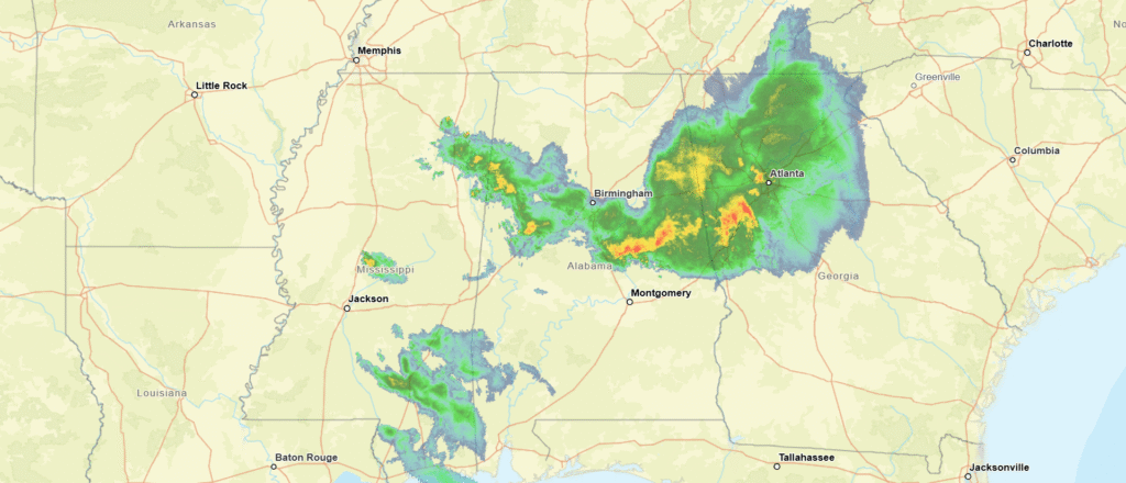
It’s certainly not unheard of to have severe weather in March. In fact, it’s pretty standard for the first major spring storms to start appearing as early as mid-February nowadays. If there has been anything strange, it is that the storms haven’t been as problematic for Mississippi and Alabama, frequent targets for early season outbreaks.
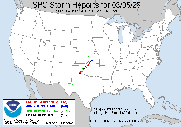
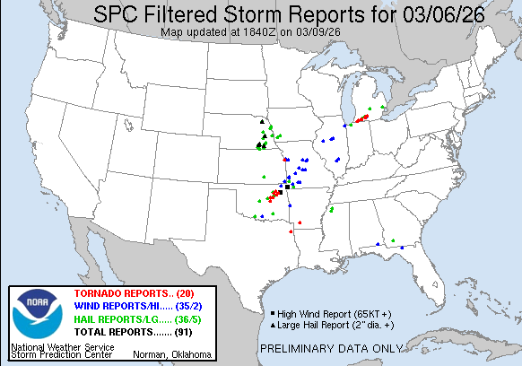
This past week has featured deadly tornadoes in both Oklahoma and Michigan. Both locales are certainly accustomed to severe weather, but these outbreaks and the deaths because of them speak to the fickle nature of severe weather, rather than the particular strength of the storms in question.
In Oklahoma, there were two days of tornado related fatalities. The first came on the 5th, when a mother and daughter were killed in their vehicle in the northwestern part of the state. The guilty cell was an isolated supercell tracked from the Texas Panhandle
The storms were more widespread on the 6th, with storms, including a fatal storm in the Tulsa area. Certainly, it was unfortunate that such a storm would batter a large population center like this. Even more unfortunate was what looks like a single long track cell that went directly from Edwardsburg, Michigan to Three Rivers, Michigan to Union City, Michigan, doing this: along the way:
This storm claimed the lives of six in southwest Michigan. Aside from this cell, there were no other severe reports in Michigan. This goes to the seasonal reminder that not every tornado is in an outbreak, but all tornadoes can be dangerous. The highest threat level for those days was an “enhanced” risk in the southern Plains, while much of Michigan was labeled as marginal. It’s a reminder for added vigilance when storms are in the forecast, in case the 1 in 10 chance hits, and there are tornadoes, and your home or route is within the quarter mile width of the looming storm.
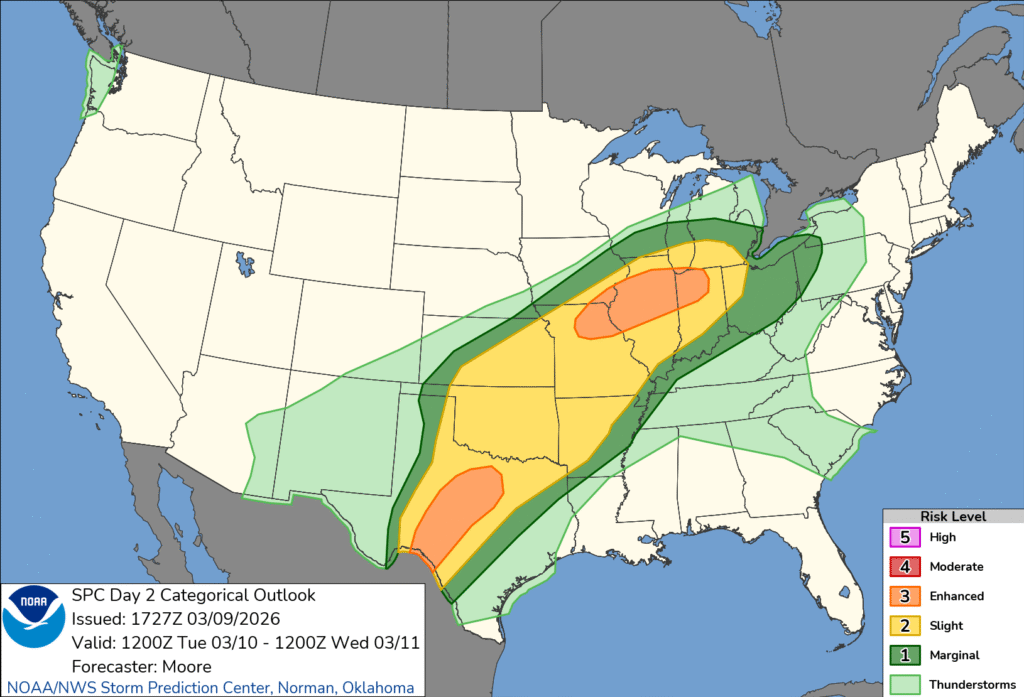
We do have more storms ahead. It is that time of year, when cold Canadian air is hanging on across the Plains, but the Gulf has started to pump heat and humidity back to the north. Our conflict zone tomorrow, will be from the Great Lakes to the Big Bend of Texas. There are enhanced risk zones at either end of the forecast thunderstorms. Be careful.
1:02PM: Oh, I did want you all to know: There will be a post later today, and it will probably not be specific to California.
9:47PM: The storms are coming tomorrow for the Plains and Great Lakes. but tonight, storms are winding down in the southeast, just where we would expect them to be this time of year.
11:55PM, Late night random thought: The Weather Channel has proven to be successful because they got the weather part of it right first. Even on the back end, they’ve been right more often than others lately. They have reinvested in clear communication. Like them or not, they are good at what they do.
It was a light posting month here at the Weather Blog, but the weather has still been wild. Fortunately, after two months, a clear cut, reliable forecaster has emerged. Two for two, The Weather Channel has won again.
10:17AM: March is definitely the weather’s silly season. There were severe storms, as the SPC called for. The deadliest storms were a series of tornadoes in southwest Michigan that claimed four lives and injured several more while moving through commercial and residential areas of Three Rivers and Union City.
Meanwhile, in Minnesota, we awoke to fresh snow.
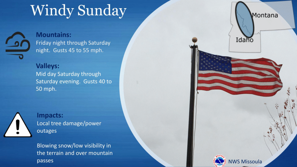
8:27PM: Everyone I know in the north is celebrating the potential 60s tomorrow. It’s great that they are even coming on the weekend, but be aware that cooler air is returning from the west at, oh, about 50mph.
5:00PM: Severe weather is breaking out in the Plains again today, so please be sure to monitor your local weather service and stations. Elsewhere, things have returned to “nearly perfect” in southern California, save for some high winds in the hills north of Los Angeles. Thankfully, normal moisture has returned, and this wind isn’t coupled with a fire threat.