The Shenandoah Valley was far enough inland that the storm system that scooted up the coast early last week didn’t bring any precipitation to Harrisonburg on Tuesday. Residents of Harrisonburg did not get to enjoy any downsloping, however, and even without the rain, the cool north Atlantic breeze suppressed afternoon highs, and Monday and Tuesday couldn’t even reach the 50s. This combination of events allowed Victoria-Weather and Accuweather to split honors. Actuals: Monday – High 46, low 24 Tuesday – High 45, Low 25
It’s a rough time for basketball fans in Michigan. Michigan State lost tonight, while Michigan lost last weekend, and both to the same team, Texas Tech. Perhaps they will cope quickly. Does Monroe have the forecast for recuperation?
At 1253AM, ET, Monroe was reporting a temperature of 46 degrees with clear sites. Dew points were also at 46, and with haze filtering in around Ann Arbor, it seems as though the morning will be hazy in Monroe. Low pressure is developing in the Plains, with a warm front already arcing through northern Michigan. Warm, moist air was spilling into the eastern Great Lakes. Low pressure will reach Michigan by this afternoon, with some rain and isolated thunderstorm activity joining it. The parent trough has been fairly shallow and is expected to move quickly across the northern US. The precipitation will ultimately punch through the region in the afternoon and evening and be out of the picture by Monday morning. It will be cooler to start the work week, but the responsible trough will be shallow enough that cold air won’t be overwhelming. Tomorrow – Rain with a bit of thunder in the afternoon, High 63, Low 46 Monday – Clearing through mid morning, and warmer, High 68, Low 53
TWC: Tomorrow – Cloudy early with showers for the afternoon hours. Thunder possible. High 58, Low 41 Monday – Cloudy early with partial sunshine expected late. High 67, Low 52
AW: Tomorrow – Increasing cloudiness, mild; spotty afternoon showers High 62, Low 45 Monday – Clouds giving way to some sun; warm High 69, Low 54
NWS: Tomorrow – A chance of showers after 2pm. Mostly cloudy, Hgh 65, Low 45 Monday – Mostly sunny, (Early rain) High 68, Low 5
WB: Tomorrow – Mostly cloudy. Slight chance of rain in the morning, then rain showers likely and slight chance of thunderstorms in the afternoon. High 64, Low 43 Monday – Mostly sunny, High 68, low 55
WN: Tomorrow – Mostly cloudy with isolated storms, High 65, Low 44 Monday – Partly cloudy with isolated showers, High 68, Low 50
FIO: Tomorrow – Light rain in the evening. High 60, Low 40 Monday – Mostly cloudy until night. High 64, Low 51
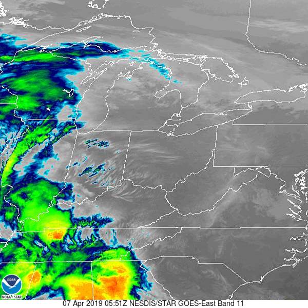
Satellite has some clouds to the southwest. That’s the rain coming later today.
NOAA/NESDIS/STAR GOES ABI BAND 11 OR_ABI-L1b-RadC-M6C11_G16_s20190970551218_e20190970553591_c20190970554048.nc
We were very busy in March. Even despite our complete website collapse, we fit 11 forecasts in, so we definitely feel comfortable in saying that The Weather Channel did enough to prove that they were the forecaster of the Month. It’s even more impressive than that, as they had 4.5 wins in March alone, and went from the lowest forecast win total for the year to the lead. Nice work, Weather Channel!
We’re looking at a pretty active week in New England, and it ended with a bit of inclement weather last week as well. Anarea of low pressure slashed through New England and brought wind and rain to the region on Thursday and Friday, including in Worcester, where we had stopped in for a forecast. Things remained much cooler than in the forecast as a slow moving cold front proved inhibiting to solar radiation. Victoria-Weather was one of the handful of outlets that correctly called for rain (and they got .14″ which isn’t anything to sneeze at) and we also happened to be on the cool side of forecasters. Those two factors were enough to secure victory. Actuals: Thursday, High 50, Low 25 Friday – .14 inches of rain, High 51, Low 38
We’re taking our situation to the lee side of the Appalachians. It doesn’t seem like a heavily populated area, but there are many small cities from Winchester in the north to Charlottesville, Roanoke and Blacksburg with Harrisonburg in the middle.
At 935PM, ET, Harrisonburg was reporting a temperature of 37 degrees with clear skies. There was a brisk flow off the mountains, with some overcast over West Virginia, but it was chasing low pressure that had shifted off shore. The area of low pressure over the Canadian Maritimes that was trailing the cold front was parented by a trough with a tail into the Great Lakes, however the jet had dug all the way to the Gulf of Mexico. Low pressure will develop at the base of the trough and move up the Gulf Stream. It will remain well off shore, and high pressure will remain in place over Harrisonburg, but the reinvigorated flow will keep Harrisonburg dry and cool to start the week. Tomorrow – Mostly sunny, High 51, Low 25 Tuesday – Increasing clouds, High 52, Low 25
TWC: Sunny, along with a few afternoon clouds High 50, Low 26 Tuesday – Cloudy. High 50, Low 28
AW: Tomorrow – Plenty of sun high 50, Low 27 Tuesday – Some sunshine giving way to clouds High 50, Low 26
NWS: Tomorrow – Sunny, High 48, Low 25 Tuesday – A slight chance of rain after 2pm. Partly sunny, High 51. Low 29
WB: Tomorrow – Sunny, High 49, Low 30 Tuesday – Mostly sunny in the morning then becoming mostly cloudy, High 48, Low 31
WN: Tomorrow – Sunny, High 48, Low 25 Tuesday – Partly cloudy with isolated showers, High 51, Low 29
FIO: Tomorrow – Partly cloudy starting in the afternoon. High 52, Low 32 Tuesday – Mostly cloudy throughout the day. High 49, Low 32
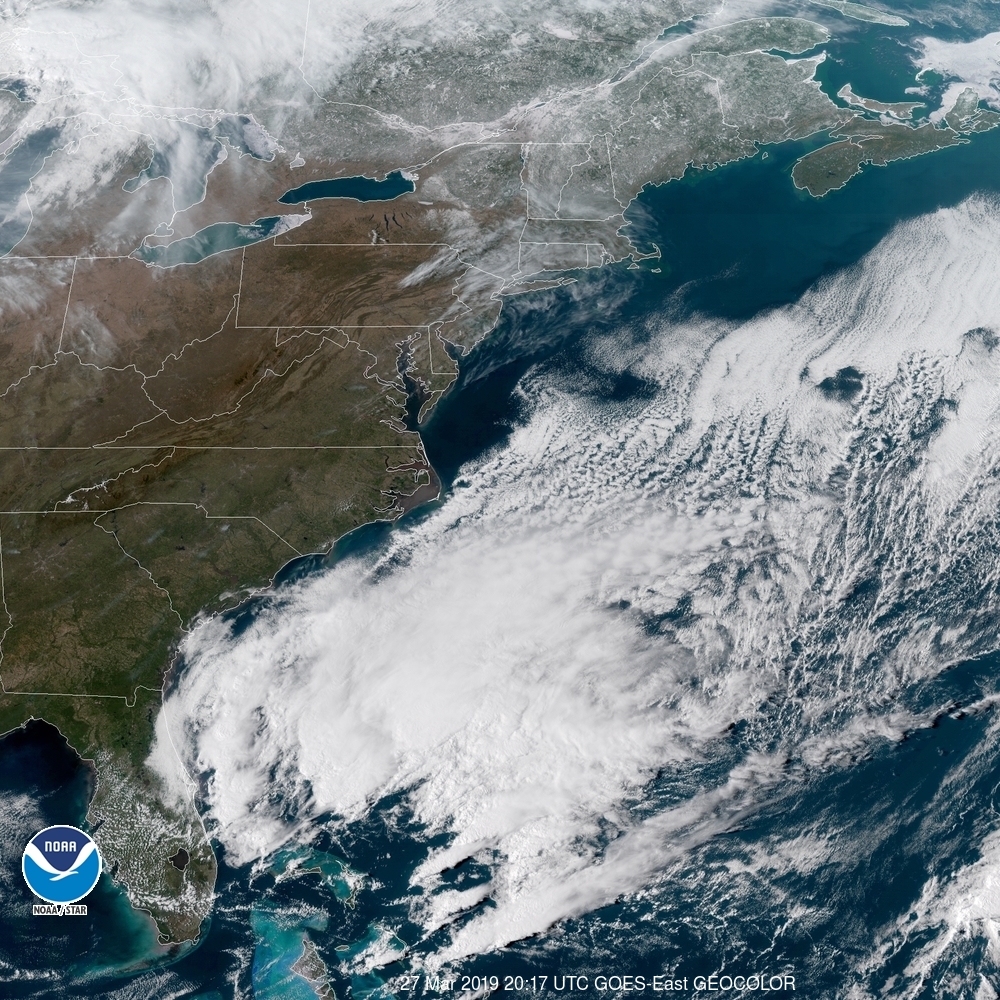
The Weather Service and WeatherNation are leaning into the NAM today, but everyone else is a bit more optimistic. Satellite tonight shows off a pretty clear night in Virginia.
There were two problems with the verification for Modesto. First, the airport on the south end of town didn’t properly maintain their records. Second, if they had, I’m not sure we would have been terribly successful. Temperatures generally ran much cooler than we had expected in the overnight hours. Maybe they would have been warmer at the proper airport, but I’m not really convinced. The temperatures were just too far off. We can still crown a winner, though, and we will. Accuweather had the top forecast for the day. Actuals: Wednesday .02 inches of rain, High 69, Low 47 Thursday – .08 inches of rain, High 66, Low 41
See, we’re definitely back! Now we even have the alliterative verification titles and everything. This is certainly a fitting one for Morgantown, where temperatures reached a balmy 65 degrees yesterday, and without any of the rain that had been a potential. The springtime warmth comforted The Weather Channel, especially, as they claimed victory. Actuals: Wednesday – High 60, Low 23 Thursday – High 65, low 39
There are two things that we can see long term that help indicate whether or not flooding is in the future. Is there a lot of snowpack ready to melt? This year, that was a firm yes. Second, is there flooding upstream? For places from Missouri south to the Gulf of Mexico, the answer is also yes. Residents are already preparing, especially on the banks of the Missouri River.
A short term impact on flooding, as in one that can arrive with much less advance warning, is rain. Flash flooding is the result of more local rains, but river flooding can be exasperated by fresh rain fall. It can also be advanced by a rapid warm up, especially if coupled with rain. This was the problem in South Dakota, Iowa and Nebraska earlier this month.
Fortunately for millions of residents, the thaw at the headwaters of the Mississippi was methodical, with refreezing overnight, and a more tempered warm up. The Mississippi and many of it’s tributaries are high, but municipalities in Minnesota and Iowa were able to anticipate the rising waters, for the most part, and have been able to stave off major issues.
And although the CPC continues to have a wetter than average beginning to April and spring season in the forecast, the ground is beginning to thaw and most of the melting above ground is complete. The Mississippi is cresting in Minnesota and starting to recede, with a major crisis averted. The good news in Nebraska, Iowa Kansas and Missouri is that any potential catastrophes aren’t going to loom more ominous than they already do.
The water was so high upstream in Nebraska and South Dakota that downstream flooding through Kansas City couldn’t be averted (though it wasn’t as bad as feared) and communities between Kansas City and St. Louis will need to be aware too, however the graciousness of Mother Nature, allaying the melting process and keeping the Midwest dry for several days, and the lower Mississippi Valley can breathe a sigh of relief.
I think we’re back! We’ve gone through a batch of forecasts, posts, verifications, etc and things look to be up and running just fine. So let’s not look back and keep an eye out on the future. What’s ahead?
Wow! Another forecast! And every single part of this city name is really tough to spell!
AT 354PM, ET, Worcester was reporting a temperature of 42 with fair skies. there were a few stray clouds across New England, but high pressure over the region ensures that they won’t amount to much. The ridge is angled north and south along he Appalachians, and will be easily moved by a cold font appended to a deep area of low pressure over Hudson Bay. The boundary will sweep in fairly early in the day on Friday, leaving a low overcast day marked by a bit of light rain throughout the day. Tomorrow – Mostly sunny, High 48, Low 26 Friday – Overcast with rain at times, High 54, Low 36
TWC: Tomorrow – Generally sunny despite a few afternoon clouds. High 51, Low 28 Friday Cloudy (early rain).,High 59, Low 39
AW: Tomorrow – Sunshine mixing with some clouds High 50, Low 27 Friday – Variable cloudiness High 56, Low 38
NWS: Tomorrow – Sunny, High 51, Low 28 Friday – A slight chance of showers after 1pm. Mostly cloudy, High 58, Low 39
WB: Tomorrow – Sunny, High 49, Low 27 Friday – Mostly cloudy, High 7, Low 38
WN: Tomorrow – Mostly sunny, High 51, Low 29 Friday – Mostly cloudy with isolated showers, High 58, Low 39
FIO: Tomorrow – Mostly cloudy starting in the afternoon. High 52, Low 30 Friday – Overcast throughout the day. High 56, Low 42
Look how empty this satellite is! Unfortunately, there will be a bit of overcast on the way. Whether or not that includes rain remains to be seen.