We visited Raleigh at the end of November, which was in the midst of a soggy stretch that, frankly, is still ongoing. It’s been such a warm autumn, and the past few winters were so mild, it’s kind of bracing to see such a chill to the air as far south as the Carolinas. But we did indeed see some temperatures that were near freezing and didn’t even get out of the 40s for the first day of December. That particular day was colder than anyone had in mind, and certainly colder than anyone in Raleigh appreciated. If you want a cold forecast, Weatherbug is your place to be, and they secured the win on this occasion. Actuals: November 30th, .22″ of rain, High 52, Low 35 December 1st, High 45, Low 35
9:04PM: Perhaps you have seen the headlines, but south Asia is recovering from a significant flooding event that afflicted parts of at least 5 countries. It started with a slow moving typhoon in the Molucca Strait, and after it moved out of the region, there was a succession of other rain storms that stretched from Sri Lanka to the Philippines. The rain led to flash flooding, and the deaths of over 2000 people across the region. The constant drum beat of news in the US has kept this disaster out of the headlines, but so too has the slow burn of this catastrophe. I encourage you to spend some time reading up on this storm, and sparing a thought for the souls that couldn’t escape.
11:43PM: I don’t know if you caught much NFL action today, but there were some wet and marshy fields out there, and plenty of snowy turf as well. The snow and rain is really tapering off in the New England area, but rain looks like a good bet for Georgia tomorrow.
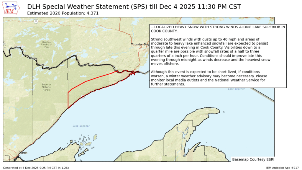
9:45PM: Lake effect snow is possible on either side of the Great Lakes, we just here about it more frequently to the east of the lakes, because that is the the prevailing direction of air flow in the Northern Hemisphere. Every once in a while, you get a northeasterly wind off of Lake Superior, and you suddenly have heavy lake effect in the Minnesota Arrowhead. The area is bound by a little bit of terrain, so the snow isn’t even showing on radar, and it is seeing some orographic forcing as well. This could be a pretty good dumping.
11:21PM The next system to batter the East Coast is, well, starting to batter! Look at the coverage on this rain!
Hello, forecast friends. We are taking our forecast express to the upper Mississippi Valley for our first forecast in December.
At 1053AM, CT LaCrosse was reporting a temperature of 22 degrees with mostly cloudy skies. There was a sharp trough angled to the southwest that divided the country in half. The ferocity of the trough was leading to overcast through the region, and a little bit of light snow throughout the north central US, however the severe angle it is taking towards the Four Corners is preventing the feature from bringing much moisture to the region. There will probably be a few flakes around LaCrosse this afternoon, but the real story is the cold high pressure behind the boundary. The tilt of the trough aloft will make it disinclined to move off its spot. The high pressure at the surface, therefore, will be similarly rooted to its location. With the ridge holding firm, the cold air associated with it will remain in place as well. Unfortunately, this time of year, sunshine can only do so much, and despite mostly sunny skies, it will remain fairly chilly through the middle of the week. Tomorrow – Some early flakes, then dropping temperatures, High 28, Low 3 Thursday – Clear and cold, High 15, Low -4
TWC: Tomorrow – Cloudy skies early, then partly cloudy in the afternoon. A few flurries or snow showers possible. High 29, Low 7 Thursday -Mostly sunny skies. High 16, Low -3
AW: Tomorrow – A morning flurry; otherwise, mostly cloudy, breezy and chilly, High28, Low 1 Thursday – A morning flurry; otherwise, mostly cloudy, breezy and chilly, High 13, Low -12
NWS: Tomorrow – A slight chance of snow before 10am, then a chance of flurries between 10am and noon. Cloudy through mid morning, then gradual clearing High 26, Low 4 Thursday – Sunny, High 13, Low -6
WB: Tomorrow – Mostly cloudy with a chance of flurries in the morning then mostly sunny in the afternoon High 28, Low 9 Thursday – Mostly sunny. High 13, Low 4
WN: Tomorrow – Partly cloudy with light snow showers, High 27, Low 4 Thursday – Mostly sunny, High 13, Low -6
CLI: Tomorrow – Overcast, High 27, Low 4 Thursday – Sunny, High 15, Low -1
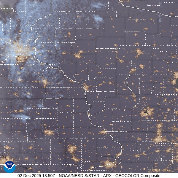
Here is a look at the afternoon satellite picture, with a few clouds smothering Wisconsin, thanks to that strong upper level jet. And yes, Accuweather is going -12 on Thursday, while Weatherbug is going 4 above. Attribute this to the GFS, which is saying -20 (!) on Thursday morning. Yikes!
12:03AM I know this is absolutely at the top of everyone’s mind, but the precipitation has not reached Raleigh before midnight, and I am just now realizing that it hasn’t reached there by 1AM, either. Raleigh is in the eastern time zone. Maybe I should go to bed?
10:10PM The troublemaking system at the end of the holiday weekend is still causing problems. There are winter storm warnings across New England, right up to the coast in New Hampshire and Maine. No waiting around for winter this year.
5:39PM: We await the next system in North Carolina. This one is a very interesting storm, as it is working into a region where the air is already cool, and bringing even colder air further south. It’s only 41 in Raleigh right now. It’s 32 in Little Rock, where sleet is falling at this hour. Is anyone ready?