Lawton, Oklahoma to Atlantic City, New Jersey

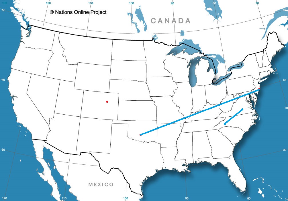
I have a NASCAR race on in the background, which makes me think that we can cover the 1,529 miles of this trip in no time. Really, though, let’s play it cool and instead make the drive in about 3 days, leaving the third day the shortest. and drive at a safe speed of 68mph, and about 547 miles a day. We will save our poor choices for Atlantic City.

DAY ONE (Monday)

Lawton, Oklahoma

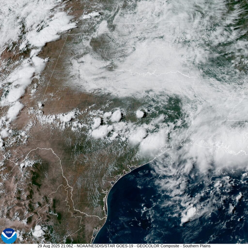
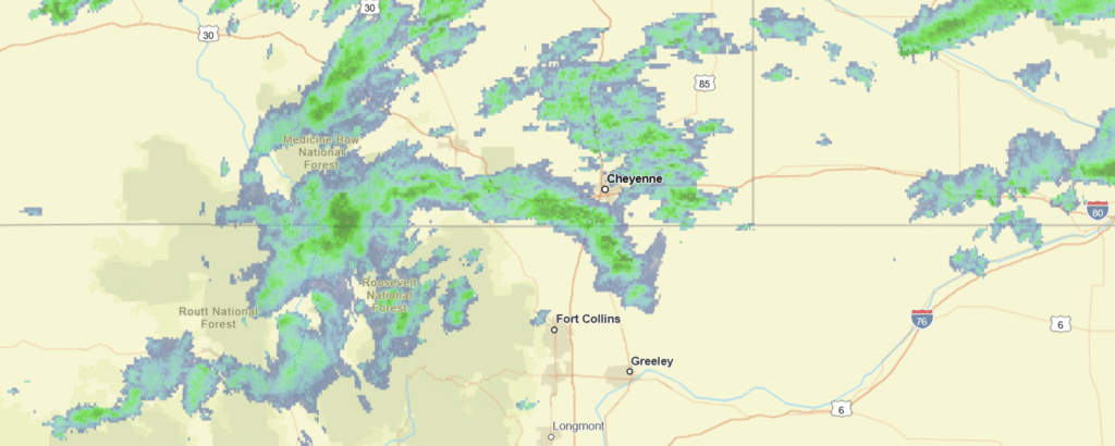
There is an eroding dry line that is washing out in the central Plains. This is producing some showers from about the Oklahoma City area to Springfield, Missouri, and there is no reason to think that this instigator will move much tomorrow. It likely won’t be as widespread as it is today. I would say the best threat will be in the higher terrain around the Ozarks, but should be fully wrapped up before we reach Sullivan, MO. Definitely before we hit Fenton, on the southwest side of St. Louis and our destination for the night.

DAY TWO (Tuesday)
Our weak trough is going to start to consolidate and turn around over night. It’s going to shift towards the Tennessee Valley, which should keep it juuuuuust far enough south to keep us dry for the day. There will be a few dark clouds dappling the sky as we continue east, and they will probably linger thorughout the day. Aside from maybe a sprinkle early in the morning as we pass through St. Louis, I think we are probably OK. The best bet for another shot of rain, albeit low, will come in the last couple of hours, from Columbus to Bannock, which is just outside of Wheeling, and our destination for the night.

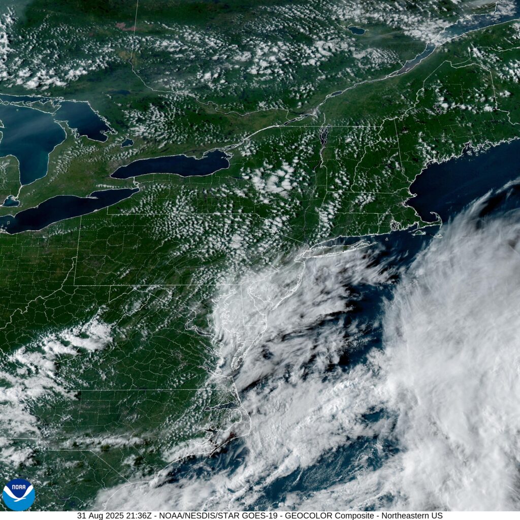
DAY THREE (Wednesday)
That same trough will waste itself on the Appalachians and spread along the range. There will be some splashes of rain, particularly on the western faces of the range for the first part of the day. We’ll have rain through about Bedford, after which point the weak system will have a tough time transcending the Appalachians. The sun will be shining in Atlantic City when we pull in.

Atlantic City, New Jersey

Atlantic City, New Jersey

After bouncing around the middle of the country recently, we will now head to the East Coast, where we will probably see things like “the Gulf Stream” mentioned a few times.

At 454PM, ET, Atlantic City was reporting a temperature of 74 degrees with clear skies. There is a thatch of clouds over Delaware Bay, associated with an upper level trough. There is a jet streak over the western Atlantic, but surface high pressure is keeping things rain free in the mid-Atlantic.
There is a bit of moisture in the middle of the country that will struggle to ascend the Appalachians. Low pressure following the Gulf Stream is moving at the eastern periphery of coler air, and the northerly flow in New Jersey will keep the region unseasonably cool.
Tomorrow – Mostly sunny, High 74, Low 56
Tuesday – Mostly cloudy, High 76, Low 55

TWC: Tomorrow – Sunshine and clouds mixed High 73, Low 60
Tuesday – Partly cloudy High 74, Low 60

AW: Tomorrow – Partly sunny and windy; a nice afternoon for outdoor activities High 74, Low 62
Tuesday – Nice with plenty of sunshine High 72, Low 61

NWS: Tomorrow – Sunny, High 75, Low 64
Tuesday – Sunny, High 75, Low 62

WB: Tomorrow – Sunny, High 70, Low 64
Tuesday – Sunny, High 72, Low 63

WN: Tomorrow – Mostly sunny, High 74, Low 64
Tuesday – Mostly sunny, High 74, Low 63

CLI: Tomorrow – Light rain showers, High 73, Low 59
Tuesday – Partly cloudy, High 74, Low 59

Looks like south Jersey is in for a good Labor Day. Clouds entering the area are high, and not as threatening as they might look.

Lawton, Oklahoma

Lawton is home to Fort Sill, which also gives us most of the population. The town is in the southwest part of the state, which leaves it in a dryer patch of land this late in the summer.

At 353PM, CT, Lawton was reporting overcast skies with a temperature of 77 degrees. Dew points were also in the upper 60s, making for a rather soupy afternoon. The tail of a cool front was triggering some thunderstorms in Texas, and westerly flow over the Rockies was contributing to a particularly vigorous dry line, leading to severe weather in the Colorado Plains. All the while, an upper level ridge is keeping Oklahoma dry, if a bit on the cloudy side.
As the upper level jet streak shifts further to the east, it will weaken greatly. The dry line will press east as well, but without as much momentum. The threat of showers and storms will arrive in southern Oklahoma on Sunday morning. The associated boundary will continue to weaken, and there won’t be any organized shower activity. As the afternoon wears on, the threat will lessen as the former dry line mixes out. The extra clouds will keep temperatures moderated.
Tomorrow – Mostly cloudy, High 80, Low 69
Sunday – Scattered showers, mostly cloudy, High 84, Low 68

TWC: Tomorrow – Isolated thunderstorms in the morning, then cloudy skies late High 80, Low 68
Sunday – Showers in the morning, then partly cloudy in the afternoon. High 85, Low 69

AW: Tomorrow – Humid with a shower in places; cloudy in the morning, then intervals of clouds and sunshine in the afternoon High 81, Low 69
Sunday – Humid with sun and some clouds; a thunderstorm in the afternoon High 86, Low 69

NWS: Tomorrow – A 50 percent chance of showers and thunderstorms, mainly after 7am. Mostly cloudy, High 81, Low 68
Sunday – A 50 percent chance of showers and thunderstorms. Mostly cloudy High 83, Low 69

WB: Tomorrow – Mostly cloudy in the morning then becoming partly sunny. A chance of showers with a slight chance of thunderstorms High 78, Low 69
Sunday – Mostly cloudy in the morning then becoming partly sunny. A chance of showers. A slight chance of thunderstorms in the morning then a chance of thunderstorms in the afternoon. High 79, Low 69

WN – Tomorrow – Partly cloudy with scattered showers and isolated thunderstorms, High 80, Low 64
Sunday – Mostly cloudy scattered showers and chance of storms, High 83, Low 68

CLI: Tomorrow – Thunderstorm, High 79, Low 67
Sunday – Light rain showers, High 84, Low 69

It looks like a pretty good holiday weekend is coming up for southwest Oklahoma. Spots of rain, but temperatures are manageable. Not so bad on satellite this afternoon.

Nonsense

Chalk one up for the Front Range. Fort Collins’ forecast didn’t quite go as anticipated. Most notably, after a cold front moved through Friday into Saturday, temperatures… climbed into the low 80s. Then, the day when westerly flow arrived with the next feature (Sunday) the expected warm downslope flow was actually cool. Temperatures dropped nearly 10 degrees. Weatherbug was 10 degrees off on their high temperature on Saturday. They missed out on first place by 1 degree. Does that paint the picture for you? The Weather Channel and Accuweather converged at the top.
Actuals: Saturday: .01″ of rain, High 82, Low 64
Sunday: .07″ of rain, High 74, Low 58

Grade: C-D

About that slow hurricane season

It’s been a pretty tame North Atlantic season thus far. The most headline grabbing feature thus far was Emily, a strong storm to be sure, with the greatest impact a dangerous surf seen along the Eastern Seaboard. This has been perpetuated by Fernand, currently churning in the western Atlantic. We are to late August, just a couple of weeks from the traditional peak of the season, and that is as wild as it has been.

Last year unleashed a torturous season, with hurricanes Helene and Milton doing damage in the southeastern US after Beryl had slogged through the Texas coast earlier in the season. Perhaps, with those names, you already recognize where I am going with this line of thought. Obviously, Helene – H and Milton – M, would come after where we are at with Fernand – F. Things can still get busy! That’s true, but also not the full point I was preparing to make.

At this point last year, Francine, 2024’s F storm, was still a month out. By this point in the year, 2024 had one fewer storm than we do in 2025. Certainly, there is a lot of season left to go, but also, 2025 hasn’t been abnormally slow, either.

The true assessment of a busy or not busy season will come at the end of the year, after we see where and with what intensity storms arrive on the coast. Since the news cycle hasn’t been overwhelmed by stories of landfalling hurricanes, we haven’t really thought about any tropical weather. That may change, perhaps not. Whatever the case, the Atlantic basin sure hasn’t been quiet this summer.

It’s a …. heat

One could interpret my headline in two different ways. The … representing a gap where one might typically say a “dry” heat, but it wasn’t that in Midland during our forecast period. Nor was it obnoxiously humid, with dew points dipping into the 50s overnight. Or, you could interpret it as a heat, as in a dead heat, because three outlets drew level this time around. The Weather Channel, Weather Service AND WeatherNation ended with the same score. Two forecasts down this month, and two results with a 4 way then a 3 way tie.
Actuals: August 14th, High 99, Low 74
August 15th, High 96, Low 78

Grade: A=B

July Forecaster of the Month

Yes, we are pretty deep into August, but it’s been a somewhat active summer on the family front, so the gears at Victoria-Weather are moving a bit slowly. It’s been a busy summer, but not in the tropics. and the severe weather has been related, largely, to heavy precipitation this year. Perhaps partly because of the dynamics of the season, and certainly because of their skill in general, The Weather Channel is having a very strong stretch, and this year just keeps getting better for them.

Outlet Forecast Wins (year)
The Weather Channel 7
National Weather Service 6.33
Accuweather 5
Clime 3.5
Weatherbug 3
Victoria-Weather 2.83
WeatherNation 2.33

Everyone is invited!

It was a hot time in Pine Bluff on the 7th and 8th of the month. Of course, that is when we put together our forecast for the city, one that resulted in temperatures in the mid to upper 90s during the day, and temps that wouldn’t cool out of the mid 70s overnight. Uncomfortable, to be sure, but all outlets were pretty comfortable with each other’s forecast. There was a 4 way tie at the top, and only three degrees of difference separating top and bottom. It was The Weather Channel, Weather Service, WeatherNation and Clime all conglomerating at the top.
Actuals: August 7th, High 94, Low 73
August 8th, High 97, Low 76

Grade: B-C

Fort Collins, Colorado

Having some minor (I hope) server issues today at Victoria-Weather HQ. That shouldn’t change the weather in Fort Collins, though, right? What can we expect in Northern Colorado this weekend?

At 956AM, MT, Fort Collins was reporting a temperature of 77 degrees with clear skies and a brisk north wind. There is a bit of shower activity across northern Colorado is associated with a cold front appended to an area of low pressure in western Ontario. A leading trough has switched winds to northerly across Fort Collins, but the boundary remained just to the north in southern Wyoming. Shower activity is largely found in the mountains west of Fort Collins and Cheyenne, though there will be some light activity as the day wears on, lasting into the morning tomorrow.
As the area of low pressure moves on to the east, high pressure will build in the Plains. In the southwest, warm air will begin to build again, and a laminar flow over the Rockies will lead to a down-slope and lee troughing in the Colorado flatlands. The contrast in air mass will lead to some ridge-riding thunderstorms in eastern Colorado by Sunday, but guidance and intuition suggest that the bulk of the activity will be south of the Palmer Divide, leaving Fort Collins mostly unbothered, but late in the period some activity could press into the area.
Tomorrow – Isolated showers, especially early, High 74, Low 60
Sunday – Partly to mostly cloudy, isolated thunder late High 80, Low 57

TWC: Tomorrow – Scattered thunderstorms in the morning. Partly cloudy skies late High 78, Low 61
Sunday – Partial cloudiness early, with scattered showers and thunderstorms in the afternoon High 75, low 51

AW: Tomorrow – Low clouds breaking for some sun with a thunderstorm in one or two spots High 76, Low 60
Sunday – Intervals of clouds and sunshine with a thunderstorm or two in the afternoon High 76, Low 55

NWS: Tomorrow – A chance of showers, with thunderstorms also possible after noon. Mostly cloudy, High 75, low 59
Sunday – Showers likely and possibly a thunderstorm between noon and 3pm, then showers and thunderstorms likely after 3pm. Partly sunny, High 79, low 58

WB: Tomorrow – Mostly cloudy. Chance of showers in the morning then a chance of thunderstorms in the afternoon High 72, Low 60
Sunday – Thunderstorms likely. High 74, low 56

WN: Tomorrow – Mostly cloudy with scattered showers and a chance of storms, High 75, low 59
Sunday – Mostly cloudy with light showers and scattered storms, High 79, Low 58

CLI: Tomorrow – Thunderstorm, High 76, Low 60
Sunday – Thunderstorm, high 78, low 56

Count me in the “not likely” camp on Sunday thunderstorms. Everything right now just looks like it will show up too far to the south. Not today though, here is radar imagery, with showers heading in from Wyoming.