We’re off on… what’s this, a single day road trip? Well, this journey will take the better part of the day, covering 469 miles of pure Midwest. The pace in the end will be 62.3mph, slowed, as you might expect, by the city of Chicago.
Saginaw, Michigan
Man, it is hot in the Upper Midwest, and some of that heat is going to spread eastward. And don’t even get me started on the humidity. Air conditioners will be needed, particularly after we get away from the westerly flow off of Lake Michigan. Chicago westward through Illinois and into Deubuque will be blazing hot. The moisture is currently penned west of the Mississippi and north into Wisconsin, and there isn’t really a great reason to expect it to get unleashed terribly far from where it is right now. It will probably bleed south and east a bit, precariously close to our route, but all that will mean is an even more uncomfortable walk to the rest rooms at pit stops. Dubuque is going to be extremely sweaty tomorrow afternoon.
It’s been a very hot summer so far out west and in the northern US. The Great Lakes haven’t been spared, but Saginaw did catch a break as June turned to July. There was a little bit of rain on the last day of June, with temperatures in the 80s, and it got even cooler on July 1st, without any rain. That’s outdoors weather! Forecast.io claimed a victory, going dry on the 1st, and getting the best temperature numbers overall. Actuals: Wednesday, June 30th, Rain reported, not measured, High 83, Low 72 Thursday, July 1st, High 73, Low 58
So many of our trips are west to east, but not enough follow the longitude more closely. Our drive will last for two days and cover 1025 well interstated miles. The pace will be a swift 67.4mph thanks to the busy roads we travel. Day one will be the longer of the two days, requiring us to cover 539.5 miles. Not much longer, but it still counts as longer.
DAY ONE (Wednesday)
Valdosta, Georgia
Summer is all different things to all different people, and this year, with the wide variety of weather hitting different neighborhoods, there is a little something for everyone. The southeast generally sees popcorn showers and thunderstorms every afternoon during the dog days. There will indeed be a few isolated showers and storms over Georgia, populating earlier than normal. There will be a hazy pause in eastern Tennessee, but a stalled surface trough, running perpendicular to our route, will be the source of showers and storms as we trek into Kentucky. The threat for rain will be highest for the last hour or so, as we pull into Pittsburg, near London, Kentucky.
DAY TWO (Thursday) That surface trough is orphaned in the Ohio Valley, and will continue to be a source of precipitation on Thursday. As time progresses though, a perturbation will develop in this trough, and rain fall will organize and become heavier by the time we leave. The best threat for heavy rain with isolated thunderstorms for the entire trip will be from the beginning of our day on Thursday through about Sidney, Ohio. Dry air is likely in northwest Ohio, with a stray shower repopulating around Saginaw Bay, just at the very tail end of this soggy drive.
The greater Saginaw area is one of the more surprisingly well populated regions out there, in my opinion. Let’s get all those Michiganders a forecast.
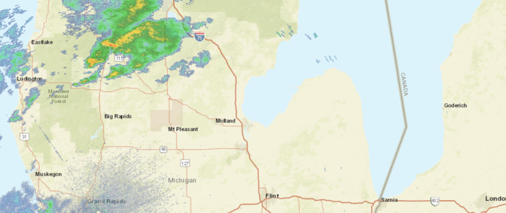
At 953AM, ET, Saginaw was reporting fair skies with a temperature of 79 degrees, Clouds were looming just to the northeast, with nearby Midland reporting overcast conditions at the leading edge of a slow moving boundary, which has produced training, flash flooding rains from the central Plains to the Great Lakes. The nearest batch of rain to Saginaw was lingering to the northwest around Houghton Lake. The upper level trough that has led to the persistent rain in the region is finally showing some mobility, as it is strengthening in flow but receding in it’s amplitude. As a result, showers and thunderstorms across Michigan today look to be a little more robust, and a stray severe storm can’t be ruled out. For all the mechanisms of the upper level trough, it still doesn’t look to be terribly progressive, and will instead pulse from Ontario into the US. Today looks to be the stormiest day of showers and storms, but they will likely recur on Wednesday and Thursday, however without the same vigor. Thursday in particularly looks like precipitation may be absent the thunder, and that much of the day will be sunny. Tomorrow – Mostly cloudy with scattered showers and storms, High 82, Low 68 Thursday – Isolated showers, otherwise cooler with sun, High 76, Low 62
TWC: Tomorrow – Mostly cloudy skies early, then partly cloudy in the afternoon. High 83, Low 68 Thursday – Partly cloudy early followed by mostly cloudy skies and a few showers later in the day. High 74, Low 63
AW: Tomorrow – Mostly cloudy and humid; a thunderstorm around in the afternoon High 82, Low 68 Thursday – Times of clouds and sun with a shower in the area; cooler High 72, Low 63
NWS: Tomorrow – Showers likely, with thunderstorms also possible after 8am. Mostly cloudy, High 82, Low 69 Thursday – A chance of showers and thunderstorms. Mostly sunny, High 75, Low 63
WB: Tomorrow – Partly cloudy with a 50 percent chance of showers and thunderstorms, High 81, Low 69 Thursday – Partly cloudy with a 50 percent chance of showers and thunderstorms, High 74, Low 65
WN: Tomorrow – Mostly cloudy with showers likely, High 82, Low 69 Thursday – Partly cloudy with chance of storms, High 75, Low 63
FIO: Tomorrow – Possible light rain overnight. High 82, Low 69 Thursday – Partly cloudy throughout the day. High 74, Low 61
It’s striking to see how cool Saginaw will be, particularly in the wake of our post yesterday about the Pacific Northwest. Below is the radar, with rain over northern Michigan.