Modesto, California to Danville, Illinois

We are headed towards the middle of the country, on a drive that will spend quite a bit of time on I-80. It will take 4 days to cover this ground, because America is a big country. Expect a pace of about 69.4 mph, which is pretty great, actually. Hopefully, the weather will cooperate as well.

DAY ONE (Thursday)

Modesto, California

There is some signal that there will be an active monsoon, spreading as far west as the Cascades and northern Sierras. Not really the monsoon, I guess, at that point, but it will follow a similar diurnal pattern. I wouldn’t expect it to occur far enough or early enough in California to be a concern, and the drive through Nevada will be generally featureless, both with the weather and the man made structures. The day will end in Welcome, as we approach the Utah border.

DAY TWO (Friday)
The monsoon will make more sense on Friday, following the Front Range in Colorado and Wyoming, which we will approach on our second day on the road. We’ll make it to the Akal rest area west of Laramie, and we may see a spot of rain at the end of the day. Nothing overwhelming, surely, and definitely not anything that will substantially slow us down.

DAY THREE (Saturday)
The impulse coming away from the front range, the one that we approached at the end of our Saturday drive, will lurk through central Nebraska for much of our Saturday drive. There will be patchy clouds, some spots of rain, heavy at times, and an isolated thunderstorm. We will take our turn off of I-80 in Lincoln and make it to Palmyra for the night. By that point, those showers and storms should be ramping up, and we may be in for quite the stormy evening.

DAY FOUR (Sunday)
I didn’t realize when I was looking ahead to this forecast that we were spending none of our time on Sunday on I-80, and in fact, very little of our time will be on an interstate. We will make it across northern Missouri on US 36, but we will leave the weather in Nebraska (and maybe a bit in Iowa). The trough bringing storms to Palmyra will stall and provide some steadier rain for the eastern part of the Cornhusker state. By the time we have reached St. Joseph and turned on to 36, we will have reached the end of the precipitation for our journey. We will cross Missouri in mostly sweltering sunshine before crossing the Mississippi in Hannibal and finally slicing through the heart of Illinois to reach our destination in Danville. It will feel summery to end the weekend.

Danville, Illinois

Modesto gives us all problems

There were two problems with the verification for Modesto. First, the airport on the south end of town didn’t properly maintain their records. Second, if they had, I’m not sure we would have been terribly successful. Temperatures generally ran much cooler than we had expected in the overnight hours. Maybe they would have been warmer at the proper airport, but I’m not really convinced. The temperatures were just too far off. We can still crown a winner, though, and we will. Accuweather had the top forecast for the day.
Actuals: Wednesday .02 inches of rain, High 69, Low 47
Thursday – .08 inches of rain, High 66, Low 41

Grade, C-D

Modesto, California

Two forecasts in a day? I find that the only way this makes sense is to hit both sides of the country.

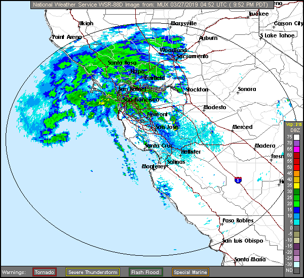
At 953PM, PT, Modesto was reporting a temperature of 61 degrees with overcast skies. There was a little bit of rain over San Francisco, and dew points were nosing into the low 50s. If there is any clearing tonight, low lying areas are likely to fog in.
A persistent area of low pressure over the Pacific is going to continue to generate a pipeline of moisture into northern California. Snow is expected in the mountains, with rain a persistent matter of fact for Modesto for the next two days. There really won’t be a change to the pattern, as this trough won’t progress, but rather dampen and fade away, making Thursday a bit less rainy.
Tomorrow – Rain, High 66, low 54
Thursday – Scattered showers, becoming less widespread, High 66, Low 48

TWC: Tomorrow – Rain showers in the morning with numerous thunderstorms developing in the afternoon. High 66, Low 55
Thursday – Partly cloudy skies during the morning hours will give way to occasional showers in the afternoon. High 64, Low 47

AW: Tomorrow – Cloudy, spotty showers; cool High 67, Low 54
Thursday – A morning shower; otherwise, times of clouds and sun; cool High 65, Low 46

NWS: Tomorrow – A chance of showers and thunderstorms, then showers and possibly a thunderstorm after noon. High 67, Low 55
Thursday – A chance of showers, then showers likely and possibly a thunderstorm after noon. Partly sunny High 65, Low 48

WB: Tomorrow – A chance of rain showers and a slight chance of thunderstorms in the morning then rain showers and a slight chance of thunderstorms in the afternoon. High 65, Low 55
Thursday – Mostly cloudy. A chance of rain showers in the morning then rain showers likely and a slight chance of thunderstorms in the afternoon. High 63, Low 48

WN: Tomorrow – Mostly cloudy with scattered showers, High 67, Low 55
Thursday – Mostly cloudy with light showers, High 67, Low 55

FIO: Tomorrow – Light rain in the afternoon. High 64, Low 51
Thursday – Partly cloudy starting in the morning, continuing until night. High 64, Low 46

Everyone seems to be on the same page, or would be, if Weathebug hadn’t filled it all up. Radar is active in the North Bay!