December came with a punch of cold air to the Upper Mississippi Valley, with the first subzero temperatures of the season arriving in La Crosse on the 4th. Fortunately, it wasn’t quite as chilly as the forecasts called for (except, ironically, Weatherbug). Unfortunately, it was a precursor to the vicious cold snap coming this weekend. Wind chills will easily eclipse -20 tomorrow morning. If you want to think warm thoughts, think about the warm fuzzy feeling The Weather Channel must have for nailing the forecast from back on the second. That should do it, right? Actuals: December 3rd, .03″ of precipitation, as snow, High 30, Low 8 December 4th, High 15, Low -2
Back in the saddle again, as we take a trip from southern Wisconsin to southern Arizona. Surely, as we reach the middle of December, this is a voyage a lot of locals wouldn’t mind taking. The drive is going to take us three days and cover 1,666 miles, which means that if weather holds, we will cover 533 miles a day at abouy 66.7mph. The final day of the trip, as often is the case, will be our longest.
DAY ONE (Thursday)
La Crosse, Wisconsin Credit: Wikideas1 – Own work
It’s been a busy time for the northern Plains. The cold seen across the Eastern US is being fed by a steady band of Clipper systems moving along the back end of the thermal trough. Another one is staged to move through on Thursday, particularly impacting Iowa in the afternoon. It will take us a couple of hours to get to Des Moines, and naturally, that should be the point of the trip where snow starts to infiltrate. I would say the chance for flakes will start around Ames and pick up. We will nearly be out of the woods by the time we reach Osceola, and at that point, it may mix with some rain. Fortunately, the rain and precipitation will cut off with warmer air as we cross into Missouri. Kansas City will offer fewer navigational headaches than Des Moines, and we will end the night in Topeka, before the Kansas Turnpike offers fewer and fewer exit opportunities.
DAY TWO (Friday) We are certainly taking a more adventurous route than we are accustomed to. We will not be haded south from Wichita, but rather west through southwest Kansas, and on some smaller roads through the various Panhandles of the region. Fortunately, the weather should be accomodating along a route that can be otherwise inhospitable. About 20 minutes before we reach Tucumcari, New Mexico from the northeast, we will end our day in Logan, New Mexico.
DAY THREE (Saturday) I think we will be happy we went south and then west. While a nother bracing shot of cold air and snow moves through the Upper Midwest and High Plains, we will be driving through the sunshine and seasonably warm air of New Mexico. The Land of Enchantment, indeed. It will be quite comfortable for our arrival in Tucson.
Hello, forecast friends. We are taking our forecast express to the upper Mississippi Valley for our first forecast in December.
At 1053AM, CT LaCrosse was reporting a temperature of 22 degrees with mostly cloudy skies. There was a sharp trough angled to the southwest that divided the country in half. The ferocity of the trough was leading to overcast through the region, and a little bit of light snow throughout the north central US, however the severe angle it is taking towards the Four Corners is preventing the feature from bringing much moisture to the region. There will probably be a few flakes around LaCrosse this afternoon, but the real story is the cold high pressure behind the boundary. The tilt of the trough aloft will make it disinclined to move off its spot. The high pressure at the surface, therefore, will be similarly rooted to its location. With the ridge holding firm, the cold air associated with it will remain in place as well. Unfortunately, this time of year, sunshine can only do so much, and despite mostly sunny skies, it will remain fairly chilly through the middle of the week. Tomorrow – Some early flakes, then dropping temperatures, High 28, Low 3 Thursday – Clear and cold, High 15, Low -4
TWC: Tomorrow – Cloudy skies early, then partly cloudy in the afternoon. A few flurries or snow showers possible. High 29, Low 7 Thursday -Mostly sunny skies. High 16, Low -3
AW: Tomorrow – A morning flurry; otherwise, mostly cloudy, breezy and chilly, High28, Low 1 Thursday – A morning flurry; otherwise, mostly cloudy, breezy and chilly, High 13, Low -12
NWS: Tomorrow – A slight chance of snow before 10am, then a chance of flurries between 10am and noon. Cloudy through mid morning, then gradual clearing High 26, Low 4 Thursday – Sunny, High 13, Low -6
WB: Tomorrow – Mostly cloudy with a chance of flurries in the morning then mostly sunny in the afternoon High 28, Low 9 Thursday – Mostly sunny. High 13, Low 4
WN: Tomorrow – Partly cloudy with light snow showers, High 27, Low 4 Thursday – Mostly sunny, High 13, Low -6
CLI: Tomorrow – Overcast, High 27, Low 4 Thursday – Sunny, High 15, Low -1
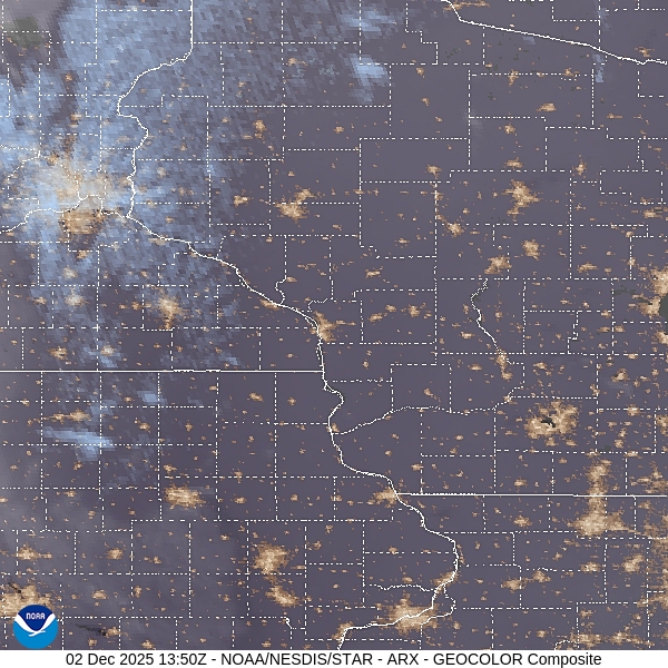
Here is a look at the afternoon satellite picture, with a few clouds smothering Wisconsin, thanks to that strong upper level jet. And yes, Accuweather is going -12 on Thursday, while Weatherbug is going 4 above. Attribute this to the GFS, which is saying -20 (!) on Thursday morning. Yikes!