The country felt summer late into fall, and fall ran late as well, so the system that clobbered the upper Midwest and Great Lakes just before Christmas was welcome for some, I’m sure of it. People dream of a white Christmas. That’s why I am going to say confidently that the blustery snow storm that hit Akron starting on Christmas Eve was probably welcome to the locals. The Weather Channel was perhaps the most open to this turn of events, not because they were in Akron, but because they had the best forecast. Active weather always causes the most nettlesome forecasts, and this was no exception, but The Weather Channel was clearly victorious. Actuals: December 23: Trace of rain, High 53, Low 25 Christmas Eve: .1 inches of total precipitation in rain/snow High 54, Low 22
It worked out mostly by accident, but today is the beginning of the NBA season, featuring the reigning champions, the LA Lakers, and their star, LeBron James, from Akron. It was meant to be.
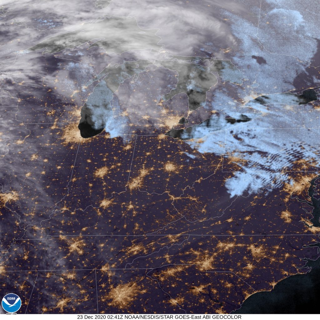
At 851PM, ET, Akron was reporting a temperature of 37 degrees with overcast skies. Winds were light across the region, but generally southerly in response to a warm front over the northern Great Lakes right now. The warm front is attached to a rapidly strengthening area of low pressure that promises to ruin the end of the week in the Upper Midwest and Great Lakes. The clouds over Akron right now are chaff found across the Eastern Great Lakes, which will shunt off to the northeast as warm air advances in ahead of the cold front coming through later this week. Wednesday should be warm, but increasingly windy and cloudy, with the front arriving on Christmas Eve, near dawn. It should be warm enough that it will start with rain, with a secondary circulation rising from the Tennessee Valley towards eastern Ohio. This advance will stall the cold air, which will dlay the transition to snow until much later, perhaps until the evening on Christmas Eve. Tomorrow – Mostly sunny, increasingly windy and cloudy, High 50, Low 32 Christmas Eve – Rain starting early, intensifying and then turning to heavy wet snow around nightfall. 2-4″ by midnight. High
TWC: Tomorrow – Cloudy skies (Late rain). High 51, Low 33 Christmas Eve – Rain early with snow in the afternoon. High 51, Low 27
AW: Tomorrow – Mild with sun through high clouds; breezy in the afternoon (Late RAin) High 50, Low 30 Christmas Eve – Rain mixing with, then changing to snow late, accumulating 1-3 inches; watch for a rapid freeze-up High 47, Low 25
NWS: Tomorrow – Mostly cloudy, High 49, Low 31 Christmas Eve – Rain before 2pm, then rain and snow between 2pm and 4pm, then snow after 4pm. High 46, Low 24
WB: Tomorrow – Mostly cloudy (late rain) High 48, Low 34 Christmas Eve – Rain, Snow in the afternoon. Light snow acumulation, High 49, Low 27
WN: Tomorrow – Mostly cloudy with isolated showers, High 49, Low 31 Christmas Eve – Cloudy with a wintry mix, High 47, Low 39
FIO: Tomorrow – Windy overnight and in the evening. High 50, Low 32 Christmas Eve – Rain (with a chance of 2–4 in. of snow) throughout the day. High 48, Low 22
It’s too bad that the forecast couldn’t come in the midst of wet weather. The NWS has rolled out new radar imagery and I could have used it. Alas, here is a look at Akron, on the cusp of clear skies. Don’t get used to them.