
One thing that I have seen many people bring up this year is the spring freeze warnings. They come up after things start thawing out, but it’s not a straight line. Frost and freeze advisories are out for those early planters, or folks with sensitive plants that have started budding on their own. The Quad Cities WFO has a whole page for residents looking for more information on the subject, and forecasts of the same.
Quiet is on it’s way
It has been a terrible weekend for a large chunk of the country. There were tornadoes most notably in Omaha, Lincoln and Des Moines on Friday, and on Saturday, the storms battered Oklahoma most notably. but also produced tornadoes from northwest Missouri to north Texas. Unfortunately, the tornadoes in Oklahoma led to one fatality, but throughout the storms, there was damage and lives upturned throughout the Plains.
Today features another enhanced risk of severe weather around the ArkLaTex. The next several days will still have a bit of a threat for severe weather, but it isn’t nearly on par with what we were concerned with through the weekend. Instead of a tornado outbreak, we’ll just see more of the garden variety thunderstorms. Strong, sure, but not historic.
As we head into the summer time season, we will think more and more about the weather. If you want to gain a bit of insight, buy the book!
Summer makes it’s approach
When we looked at Chico earlier this month, it didn’t appear that there was much of a trend, but when we bore out the actual verification numbers, it turned out that yes, there was a trend. From the 16th to the 17th it got a bit warmer, both during the day and during the night. It isn’t crazy hot yet, but this little window into April was a sign that it’s coming. WeatherNation ended up getting the top forecast, all by themselves.
Actuals: April 16th, High 75, Low 49
April 17th, High 77, Low 54
Grade: A-C
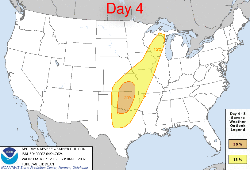
A stormy end to the week, a stormier weekend ahead
A tag team of systems moving through the country are going to bring quite a bit of severe activity through the weekend. It will be mostly in the Plains, and will start tomorrow with some significant storms possible, especially in the central Plains. The show will really get going over the weekend, though. Saturday looks like the more hectic day, as there is already a 30% outlook on Saturday, which is a long way out to think that there will be strong storms. Watch out in the highlighted areas.
Elkhart, Indiana to Fayetteville, Arkansas
It’s going to be a one day cross section of middle America. From northern Indiana to northwest Arkansas, we will take a long, 11+ hour day, covering 742 miles, for a pace of nearly 66mph. Indiana and Arkansas are closer than you think!
A weakening system over the Great Lakes is getting drawn into the sphere of influence administered by a larger system trekking through the Gulf Stream. The weaker trailer is bringing some light rain to Elkhart tonight, but will be out of the picture by tomorrow morning. The feature is dangling a trough southward before it curls to the west, where it will lie stationary tomorrow. High pressure is building in over the north central US, but it won’t overpower the boundary and send it further south. Instead, the tail of the front will pass through the Ozarks, and while we will probably use our northern route to avoid any visibility issues, we will still enjoy them in their misty glory upon our arrival in Fayetteville.
Not so bad on the coast
It can be pretty muggy in south Texas, hotter than most of us northerners an even comprehend. A temperature of 83 degrees, though, is pretty palatable, even with some humidity. That’s where it sat in Victoria on the 14th and 15th if this month, an all together comfortable set of days in a part of the world that can be notoriously uncomfortable. It was a little uncomfortable as well for The Weather Channel, who won the day, but by a narrow margin.
Actuals: April 14th, High 83, Low 63
April 15th, High 83, Low 70
Grade: A-C
I’m not happy. It’s about 40 degrees and windy, and generally, it’s colder than normal across the middle of the country. Matters were made worse when I spoke with someone in California who was talking about how warm it was today. Jokes on them, because this is the map for the 8-14 day outlook.
Take a breath
We’ve had a pretty noisy stretch over the last couple of days, with severe weather sweeping through the Plains over the last two days, and into the Mid Mississippi Valley today. High pressure is moving to the middle of the country tomorrow, and will stamp out much severe weather from then on, at least through the weekend, and perhaps through the beginning of the following week.
If you live in the center of the country, you were just experiencing some wet and stormy weather over the last couple of days, and through the end of the week, you will see temperatures that are well below normal. Great news, though, as the end of the month, nearly nationwide, is expected to be warmer than normal.
Among the places seeing warmer temperatures on the way is Phoenix. It’s not going to be crazy, but it will be a few degrees shy of 100 next week.
