
9:22PM While river flooding remains an issue along the Mississippi, it’s really gone down along the Ohio. Now, the cause is recent rains in Missouri, where some smaller creeks and tributaries are running high. With a few quiet days, the threat for any flooding should continue to wane.
Updates 4/20
953PM Another that is fairly summer like with the system sweeping the center of the country tonight: This is the last gasp. It won’t carry much energy tomorrow, because the parent system isn’t particularly well organized. This will leave plenty of atmospheric juice for things to percolate again later in the week in the southern Plains.
Updates 4/19
9:11AM – If anyone was curious, today is the type of day that southern California dreams are made of. It will be in the 70s throughout the LA Basin, and cooler down towards San Diego. It will warm slightly through the weekend, but for now, excessive heat is stayed.
Updates 4/18
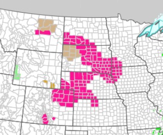
11:01AM Looks like a pretty normal one from the SPC today, with a broad swath of slight risk yellow through the middle of the country. Some seriously summer vibes out of the outlook today.

But, um…. what’s the deal with all this pink in the Rockies, NWS?

Updates 4/16
8:15PM: The week ahead is going to provide more threats for severe weather, but not nearly as vivid as it was in the past few weeks. On the north end, there won’t be the snow inducing cold air. Instead, just enough to induce this cute graphics pack from NWS Aberdeen.

May flowers incoming
Spring is known for being as damp as it is rejuvenating. We accept how sloppy the month is because we know it is going to bring about some momentous changes to the landscape. Well get ready, friends, because most of the country is going to be on the wet sides through the latter half of the month.
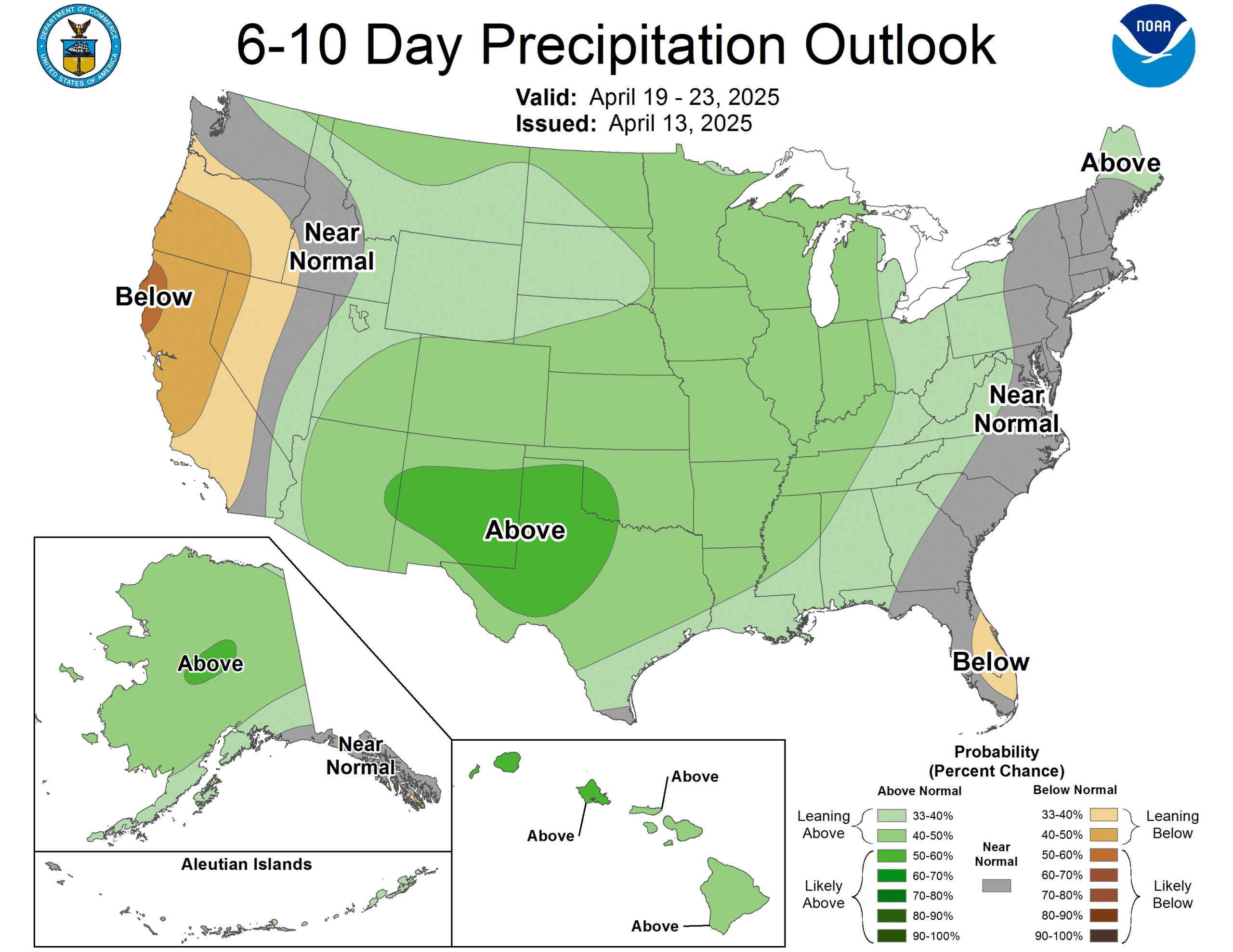
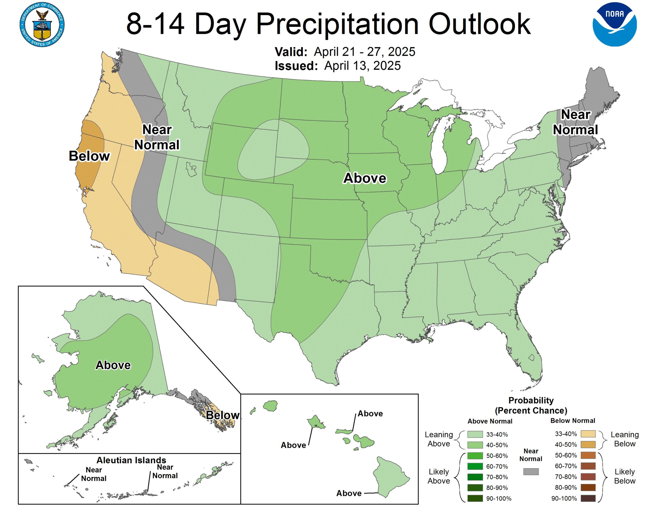
Everywhere but the west coast is looking for a rainy stretch from late this week and on to next week. There aren’t any extreme bullseyes, but even Alaska and Hawaii are going to see extra rain fall.
This, along with warm air forecast to build out east is a preponderance of “Texas Hookers” in the next couple of weeks. Generally, this would mean a broad and deep trough over the Plains. Surface low pressure starting in the southern Plains will rocket towards the Great Lakes, bringing hot, sticky weather in he warm sector, and apparently, rain everywhere.
Spring: It’s trying!
With all the talk of severe weather and heavy rain lately, it’s kind of nice that our forecast in Johnson City last week turned out to be so nice. Well, dry. Temperatures were below freezing on one morning, and crept only to the low 50s the day before, which is decidedly not what you are looking for in spring, trying to bounce back to some vibrancy. It was in the 60s by Wednesday, at least, and with luck, we won’t have to think about February and March again any time soon. The Weather Channel claimed the victory with a very good forecast.
Actuals: Tuesday, High 52, Low 37
Wednesday – High 64, Low 28
Grade: A-C
Persistent rains bring river flooding
It wasn’t a particularly snowy year in the middle of the country, which often limits the threat for downstream flooding in the Mississippi and Missouri Rivers. The Missouri looks to be ok this season, but the Mississippi is spilling it’s banks in some places, or is expected to soon in others.
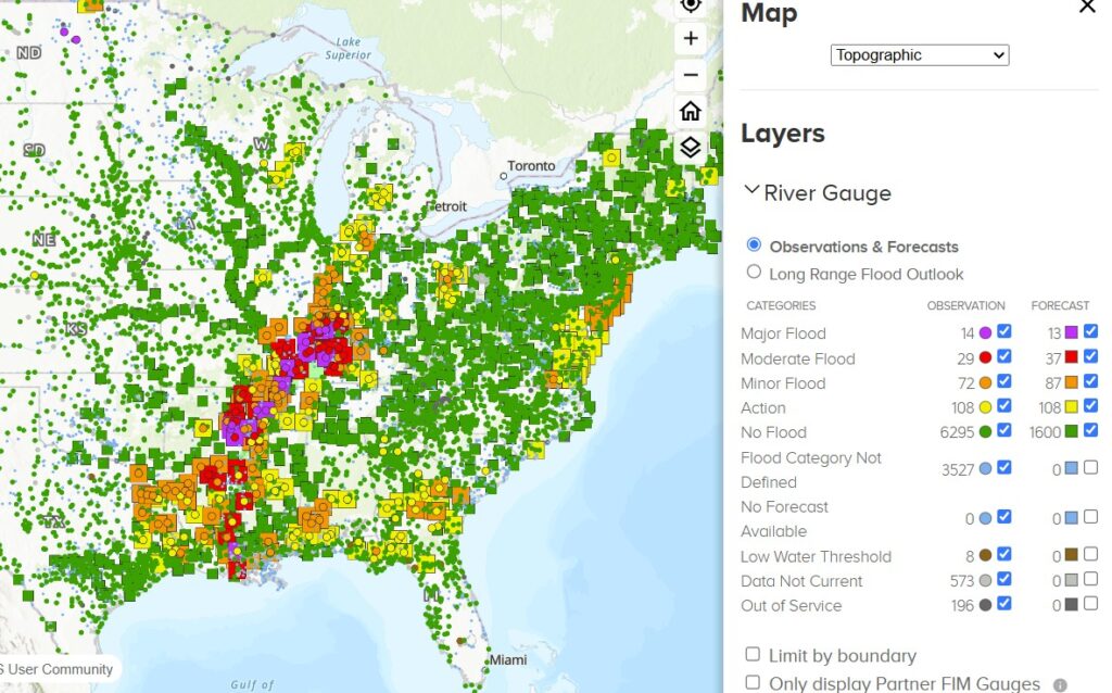
If you are a budding cartographer, you will note that the major flood stage pink squares extend away from the Mississippi. It’s the Ohio that is the origin for some of these flood waters, thanks to the persistent seen in our very active March. You will note that rivers are high in a southwest to northeast line from east Texas to western Michigan, aligned with the track of our storms last month.
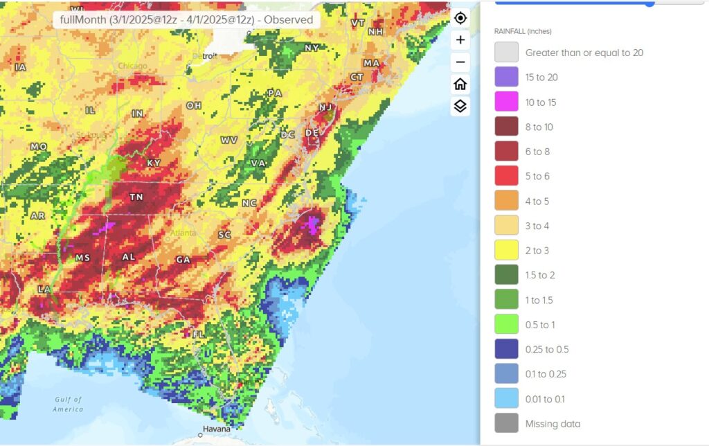
While all that rain isn’t directly over the Ohio, it would be over the Green, Cumberland and Tennessee River, all of which flow into the Ohio. Parts of downtown Louisville have been underwater thanks to the flooding. As this article notes, we are approaching Louisville’s biggest tourism season, and a flood clean up will be a difficult challenge.
As the region attempts to dry out, we are looking at a pretty dry week. This will help flood waters down river rise and fall without too many consequences. Hopefully this is the last of the river flood season.
Let’s hope for a better weekend
This time last week, we were putting together a forecast for Harrisburg, and it was looking sloppy. Unfortunately, forecasts bore out, with about half an inch of rain wetting the Keystone capital, and most of it came on Saturday, of course. If there was any silver lining, it is that residents probably knew it was coming, given the decent forecast they were given. Probably not exactly the news they were looking for, though. The Weather Channel was the issuer of the best forecast.
Actuals: Saturday, .45″ of rain, High 60, Low 51
Sunday, .07″ of rain, High 55, Low 49
Grade: A-C
Updates 4/9
11:15AM: With spring running a bit cool right now, and so many stories about rain afflicting the mid-South and Appalachia, we would be forgiven to not realize how dry the northern High Plains have been. There are red flag warnings today from northeastern Colorado through the Dakotas. Compounding matters is the surface pattern, which is allowing for winds gusting 35-45 miles an hour. If fire does crop up, they will whip up and spread quickly across the prairies.
11:25PM Weatherbug had the best month forecasting last month, and while yes, the actual forecasting was good, I have to believe that a huge part of it is that they got rid of side scrolling for hourly forecasts.