3:57PM: Time for an advisory, if you need it: it’s November now, which means you need to start reviewing the WPC page for the heavy snowfall outlooks, as well as weaning off the SPC and NHC. Thank you, and apologies.
7:32PM: More from the WPC: All that incoming snow in the Pacific Northwest has been ascribed the atmospheric river label. It’s going to be snowy!
11:13PM: All this about the cooler weather inbound, I would be remis if I didn’t point out … It’s going to be warmer than normal for a healthy chunk of the country this week.
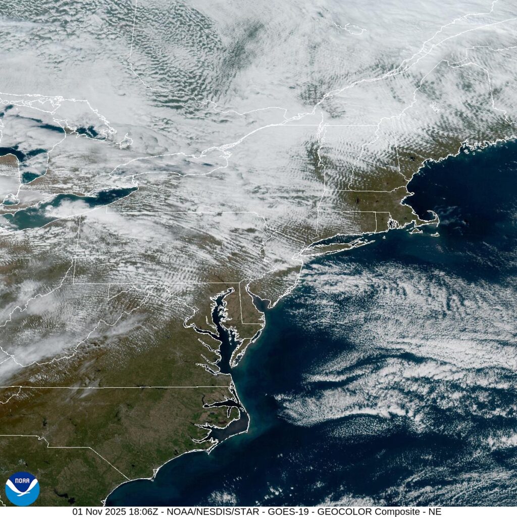
2:50PM: See how the clouds are kind of ribbed throughout New England? Well, that means it is quite windy across the region, at the level at which the clouds lie. I can tell you it is fairly breezy at the surface, as well.
9:10PM: The wind that was evident in the image above is also responsible for bringing in quite a bit of chilly air. There are actually frost advisories tonight as far south as North Carolina.
Burlington started its life called “Company Shops” because the railroads started the town as a spot to service trains in North Carolina. As railroads merged and the trains that used Company Shops put their work elsewhere, residents decided to rename the town. They picked the name “Burlington”…. naming the town after a passing train.
At 1059PM, ET, Burlington was reporting rain and low overcast. The temperature was 52 degrees. In the wake of a coastal feature that brought the region rain yesterday, another rain maker is moving out of the Tennessee Valley tonight. In this case, the area of low pressure is starting to move to the north, and an occluded cold front will be responsible for the rain overnight tonight. Because of the occlusion, the post-frontal cooldown will not be dramatic. The rain will end through the late morning, with drier air and a bit of sunshine then filtering back into the picture. High pressure will build in, giving the region a much needed break from the rain. Tomorrow – Rain early, then clearing, High 62, Low 48 Friday – Sunny, High 58, low 43
TWC: Tomorrow – Cloudy early, becoming mostly sunny in the afternoon (AM Rain) High 62, Low 49 Friday – Sunny skies. High 62, Low 43
AW: Tomorrow – Breezy in the morning; otherwise, clouds breaking for some sun (AM Rain) High 62, Low 49 Friday – Breezy in the morning; otherwise, plenty of sun; cool for trick-or-treating High 60, Low 41
NWS: Tomorrow – Cloudy, then gradually becoming mostly sunny, (AM rain) High 62, Low 49 Friday – Sunny, High 62, Low 42
WB: Tomorrow – Mostly cloudy. Showers likely in the morning. High 62, Low 49 Friday – Sunny. High 59, Low 45
WN: Tomorrow – Partly cloudy (early rain) High 62, Low 49 Friday – Sunny, High 62, Low 42
CLI: Tomorrow – Partly cloudy, High 62, low 48 Friday – Sunny, High 61, Low 42
Well, if the high tomorrow isn’t 62 degrees, I think I’m going to have to talk to someone. Pretty rainy tonight, but I did forget that Friday is Halloween, and that looks like a good night for Trick or Treating.
7:15PM: We are headed towards Halloween at the end of the week, and whether you like it or not, the weather looks to be on the warm side for a lot of the country. The core of the most above normal warmth looks to be around the Rockies, where Salt Lake City is looking at temperatures around 60 degrees. Trick or Treat!
8:15PM Hurricane Melissa’s eye has cleared Jamaica. The storm has been weakened a bit, but is still a strong storm, now readying to landfall in eastern Cuba. Melissa will weaken further over Cuba, and then will impact the southern Bahamas and Turks and Caicos islands.
Durham is one of the three members of the “Research Triangle” in eastern North Carolina, and is famous also for being the home of Duke University, who have historically had a strong basketball program.
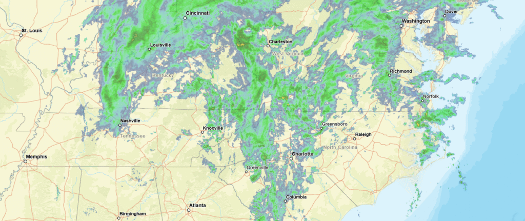
At 815PM, ET, Durham was reporting a temperature of 52 degrees with rain. There was an area of low pressure off the coast of South Carolina, and to say the least, it has been a robust rain producer, and almost the entire state east of the mountains was experiencing rain this evening. The feature is associated with a robust seasonal jet stream, and will shift into the north Atlantic, where it will help to establish a steering mechanism to keep Hurricane Melissa away from the US mainland. The pattern across the US is quite active this week. While rain will diminish by late on Tuesday, but a deeper digging trough with it’s own area of surface low pressure will be sliding through the southern US. By Wednesday, the stalled boundary associated with the low in the Atlantic will link with the rising warm front, bringing rain back into the forecast for the morning. Wednesday will see temperatures pop a bit, with some thunderstorms coming in after sunset. Tomorrow – Showers through the day, High 50, Low 47 Wednesday – Rain early, then some thunder late, High 58, Low 48
TWC: Tomorrow – Rain, High 51, Low 48 Wednesday – Considerable cloudiness with occasional rain showers. High 56, Low 46
AW: Tomorrow – Breezy and cool with rain High 51, Low 46 Wednesday – Occasional rain and drizzle in the morning followed by periods of rain and a thunderstorm in the afternoon High 57, Low 47
NWS: Tomorrow – Rain. High 52, Low 47 Wednesday – Rain likely before 8am, then showers likely, mainly after 2pm. Cloudy, High 58, Low 47
WB: Tomorrow – Rain. High 53, Low 48 Wednesday – Rain likely with areas of drizzle in the morning then showers likely in the afternoon High 55, Low 47
WN: Tomorrow – Cloudy with showers, High 52, Low 47 Wednesday – Mostly cloudy with rain likely, High 58, Low 47
CLI: Tomorrow – Rain showers, High 51, Low 47 Wednesday – Rain Showers, High 55, Low 47
Sorry, Durham. Wish I had better news for you. Look at all this rain!
We assembled a forecast for Dover ahead of the Nor’Easter that shook up the East Coast earlier this month. Yeah, it rained, sure temperatures came down, but I really wanted to see what the wind registered at. It gusted to nearly 40MPH on Sunday the 12th! After the hatches were properly battened, we could appreciate a good clustering of forecasts. Ultimately, the National Weather Service narrowly overcame the other outlets. Actuals: October 11th, .11 inches of rain, High 69, Low 52 October 12th, .43 inches of rain, High 66, Low 57
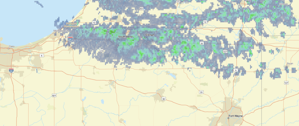
10:18PM: Well, the good news in northern Indiana is that light rain we were eyeballing in the forecast for Elkhart is on the way out. The bad news is that a feature in Texas may be a bit more virulent than anticipated initially, and could bring a spot of light rain to the area overnight tonight. Better than severe weather, though, as is being seen in the Lone Star State tonight!
There are several medium sized towns in northern Indiana, even as you get east of Chicagoland. We have four along the I-80/90 corridor in our forecast pool, Michigan City, South Bend, Goshen and today’s site, Elkhart.
-At 1215PM, ET, Elkhart was reporting a temperature of 45 degrees with light rain. Rain was more widespread in Michigan, and just nosing into northern Indiana, with showers reported in South Bend, but not Goshen. This is associated with a broad area of low pressure in western Quebec, drifting to the north. The lingering shower activity will continue through the day as the system breaks down, and it will remain cool through the day. A narrow ridge is going to be pushing the light rain out of the region, and will anchor in place for the remainder of the work week. The ridge will provide a bit of a warm up, but not dramatic. The jet associated with the upper level ridge will be local, which will lead to some clouds at the mid and upper levels, along with some persistent low clouds associated with todays event. It will be a bit warmer, with a little bit of sun on Friday. Tomorrow – Mostly cloudy, High 49, Low 44 Friday – Mostly cloudy, High 51, Low 38
TWC: Tomorrow – Showers in the morning, then cloudy in the afternoon. High 49, Low 42 Friday – Cloudy skies early, followed by partial clearing. High 52, Low 39
AW: Tomorrow – Sun and some clouds with a couple of showers; breezy and chilly High 48, low 43 Friday – Mostly sunny High 51, Low 39
NWS: Tomorrow – A 50 percent chance of showers. Mostly cloudy High 51, low 43 Friday – Mostly sunny (Rain through 2am), High 54, Low 38
WB: Tomorrow – Mostly cloudy through 4 pm then becoming partly cloudy. A 50 percent chance of showers. High 46, Low 42 Friday – Partly cloudy through 4 pm then clearing (Rain through 2am). High 51, Low 38
WN: Tomorrow – Partly cloudy with light showers likely, High 50, Low 43 Friday – Partly cloudy with showers, High 54, Low 38
CLI: Tomorrow – Rain Showers, High 47, Low 40 Friday – Light rain showers, High 50, low 37
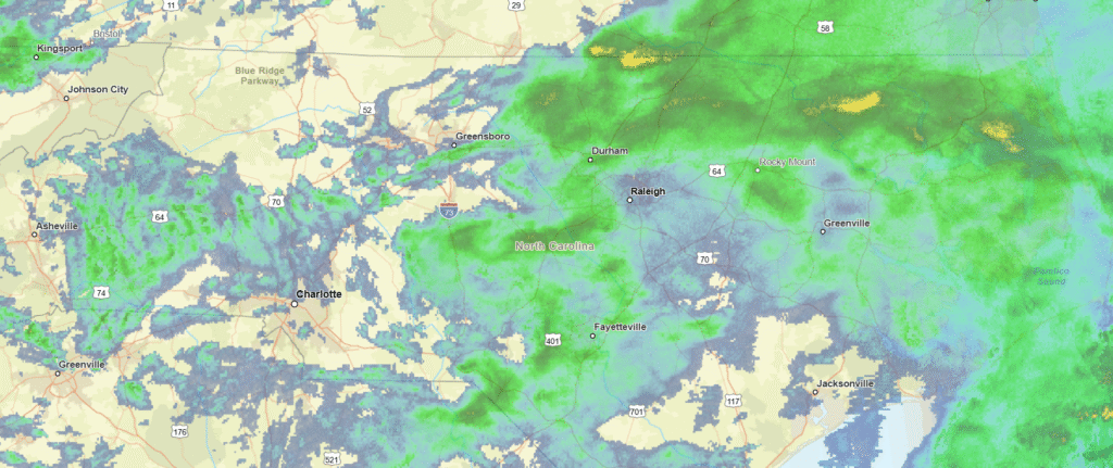
I’m not sure why so many of my compatriots are calling for rain in Elkhart. I would be surprised if it lasts the day, let alone the week. Here, take a look.
Back before my vacation, at the beginning of October, we looked at Portland, which was readying for a cool down and the advance of an autumnal area of low pressure coming out of the Gulf of Alaska. The rain never arrived, and wasn’t expected to, before the forecast period expired. Temperatures did cool off by 20 degrees, though, a jarring first taste of autumn for the Pacific Northwest. It is odd to think that the high temperatures that Portland ended up at are still 20 degrees warmer than I’m at Victoria-Weather HQ right now. Perhaps as a consolation, we can acknowledge that V-W earned the victory with some room to spare. Actuals: October 7th, High 79, Low 50 October 8th, High 60, Low 52