January was a return to winters of yore. It was cold, there was snow all the way down to Florida and nobody was happy with any of it. Winter is back, baby! On top of that return to normal, we had a return to normal in our forecast champions: The Weather Channel was the top forecaster to start 2026.
It’s been a brutal winter for the eastern part of the US, particularly in the southeast. Temperatures have been colder than normal, and there have been historic ice storms. Parts of the country have endured subzero temperatures for long stretches, while further south, even as far as central Florida, temperatures were, at times, below freezing. No longer!
The trough that has been in place over the eastern US, the lobe of the polar vortex that has made everyone so uncomfortable is now back up in the Arctic where it belongs, and a warmer batch of high pressure is moving into the middle of the country. Temperatures are warming up, first in the Plains, but eventually through the Great Lakes, Tennessee Valley and on to the East Coast.
We haven’t talked much about the West Coast, save for more normal conditions and some persistent rain earlier in the winter. The precipitation was intense at times, but more recently it has been dry and warm, just like we have grown to expect along the Pacific for the past few years. The early season rain has tamped down the concerns, and guess what? The early season rain looks like it will be late season rain as well.
In the very near future, the movement off of the persistent eastern trough is allowing generally more activity through the lower 48. Pattern movement means precipitation, as it will nationwide next week, but also, systems east of the Rockies will draw their energy from the Gulf and points southward. This is early for this sort of pattern, which means above normal temperatures for about 4/5ths of the country.
Of course, the active pattern will begin out on the West Coast, with rounds battering California before moving into the Plains, where low pressure will deepen and cause the increasing warm air and action discussed in the previous paragraph. The temperature trends are swapping coasts, and along with it, expect a stormy time ahead.
My friends, I regret to inform you that, once again, in the Carolina Plains, it will be snowing again. That is the bad news. The good news is, there is a reason that I specifically called out this particular area.
The polar vortex is still parked over eastern Canada, which means a persistently active, and most importantly, a continually cold stretch of time for America east of the Rockies. Later this week, the upper level structure is going to rotate further to the south and a bit to the east, which is going to do two important things. One, it is going to get even colder for an unfortunate chunk of the country. Additionally, it is going to push the storm track south and a bit to the east.
The trough, in its motion, is going to have improved vorticity, and an increased capacity for cyclogenesis. What does that mean? It means low pressure is going to develop towards the southern base of the trough. As I said, this feature is going to be shifting further south and a bit to the east, which means the surface area of low pressure is going to develop south and a bit east of where the weekend storm went. Offshore.
This does mean the storm going to be stronger, with a deeper central pressure. This means that despite less moisture, and a narrower focus for the precipitation,, the wind will drive most of the issues. There are blizzard watches out for the Piedmont, but there aren’t any snow accumulation forecasts for even double digits that I have seen. And absolutely no forecasts for ice.
So even with the limited precipitation relative to last week, the nature of this storm is that it will be stronger at it’s heart, colder and windier. Snow that falls will be heaviest in the Carolinas and Virginia, but there may be a few flakes along the immediate coast from New Jersey through Massachusetts, but there too, the big threat is blustery wind.
The winter weather will pick up overnight tomorrow in the Carolinas and Virginia. The wind will peak Saturday night, and will be worst in the Outer Banks. The cold will move back in and continue to linger. The good news is, this storm i narrower geographically, and won’t have ice. But it will be windy. Stay safe, and tie down the lawn chairs.
This weekend saw much of the country paralyzed, with millions losing power, thousands of flights canceled, and recovery an ongoing battle. The snow is still actively falling in parts of New England, but the thaw is not ready to move in yet. Everything that was frozen this weekend remains so.
A deep and strong trough has been ebbing and flowing across the eastern two thirds of the country for a couple of weeks now, and at long last, the surae organization matched with what was going on aloft. Low pressure developed in the Southern Plains and was able to tap into Gulf moisture, while at the same time drawing very cold air from the Canadian Prairies.
As we saw with our forecasts in Florence and Rome, several days before the storm set in, there was already cold air in place. The storm, therefore, wasn’t necessarily marked by the great conflict of air masses, but rather the incredible amount of moisture that was able to blanket the country.
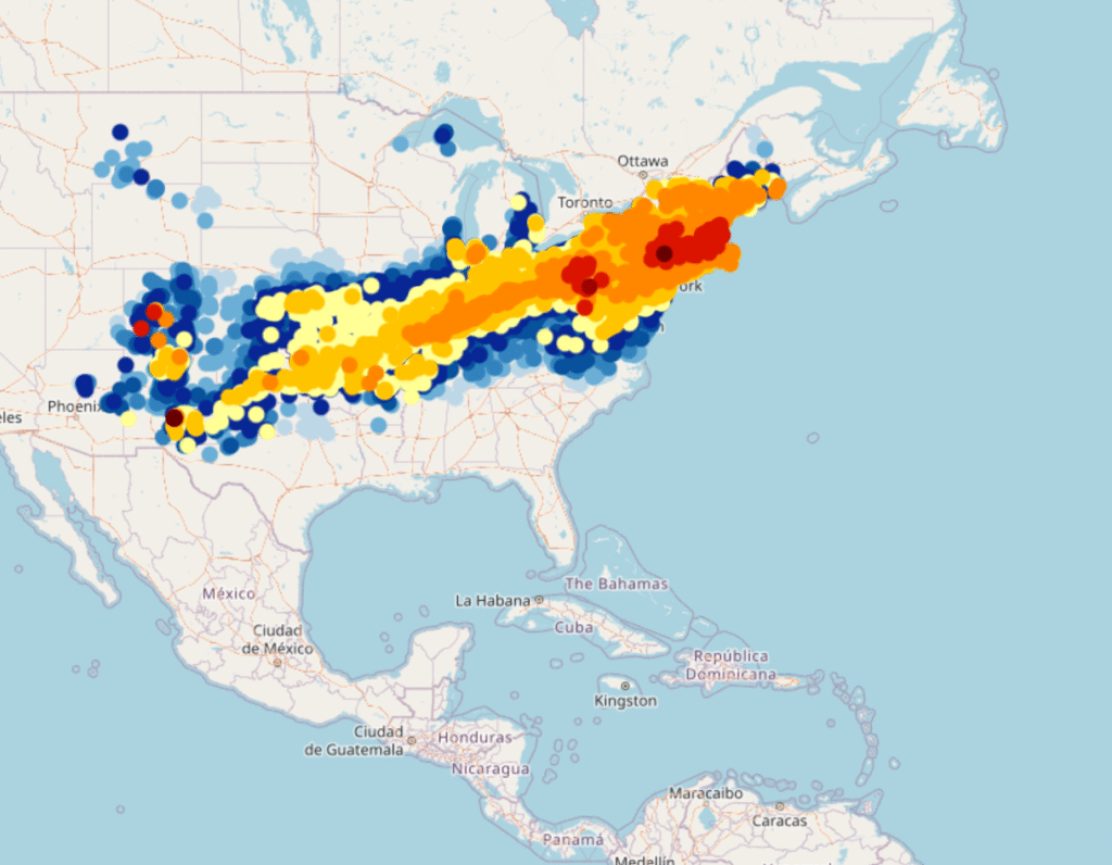
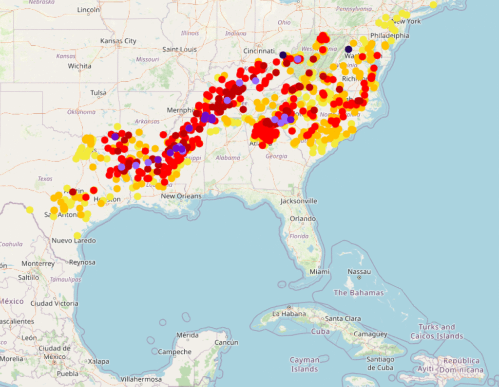
The area covered by freshly fallen snow, mapped below with the heaviest totals coming from western Pennsylvania to Massachusetts, is an elongated southwest to northeast line, starting in southern New Mexico and running to New England. It tells the story of the track of the storm, starting in the southern Plains and ending up in the Canadian Maritimes. A “Texas Hooker” to be sure. Snow was measured over two feet in some of the terrain in Pennsylvania, and well over a foot throughout Massachusetts.
A broad area of accumulated ice, pictured below, is found on the southern fringes of this vast area of snow. This is where the most significant damage you have head about is showing up, from northern Mississippi, to Nashville and on to the Carolina Plains. I saw reports of up to 3″ of accumulated ice, which is devastating. Many places saw an inch, which is debilitating in itself.
The map of this storm tells us that much of the destruction was done by a stationary front, which became a weak, meandering warm front. The cold front associated with this rotating area of low pressure had little to do with what the storm wrought. There were several severe thunderstorm reports around the Florida Panhandle, but for all intents and purposes, this was purely a winter storm.
The cold air has of course eventually found it’s way in, and is keeping all these people buried under snow and ice in a deep freeze. For this particular occasion, the cold front has worked to exasperate an existing problem, rather than being the progenitor of the problems. Cold fronts generally have it easier when they want to raise a ruckus, and are pretty expert at it in the summer and spring, when they have warm air to work with. It takes a special blend of cool temperatures, and the right oscillating warm front to cause the havoc that this weekend’s storm did.
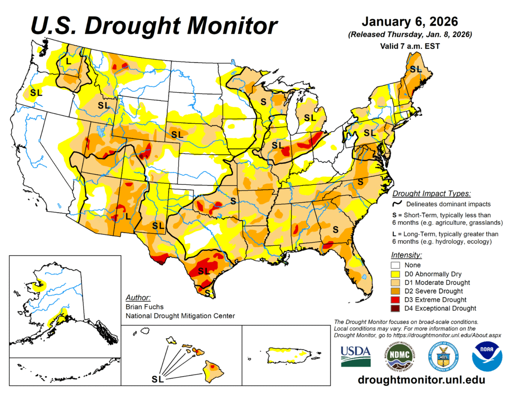
For the first time in years, California is not beset by a drought. The primary areas in which drought is ongoing this year are further inland. It’s pretty dry nearly everywhere EXCEPT California, which makes for an interesting change of pace.
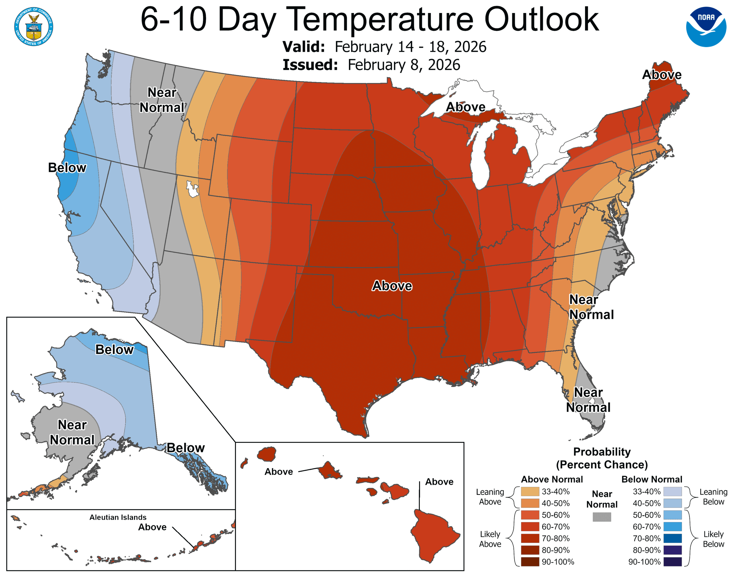
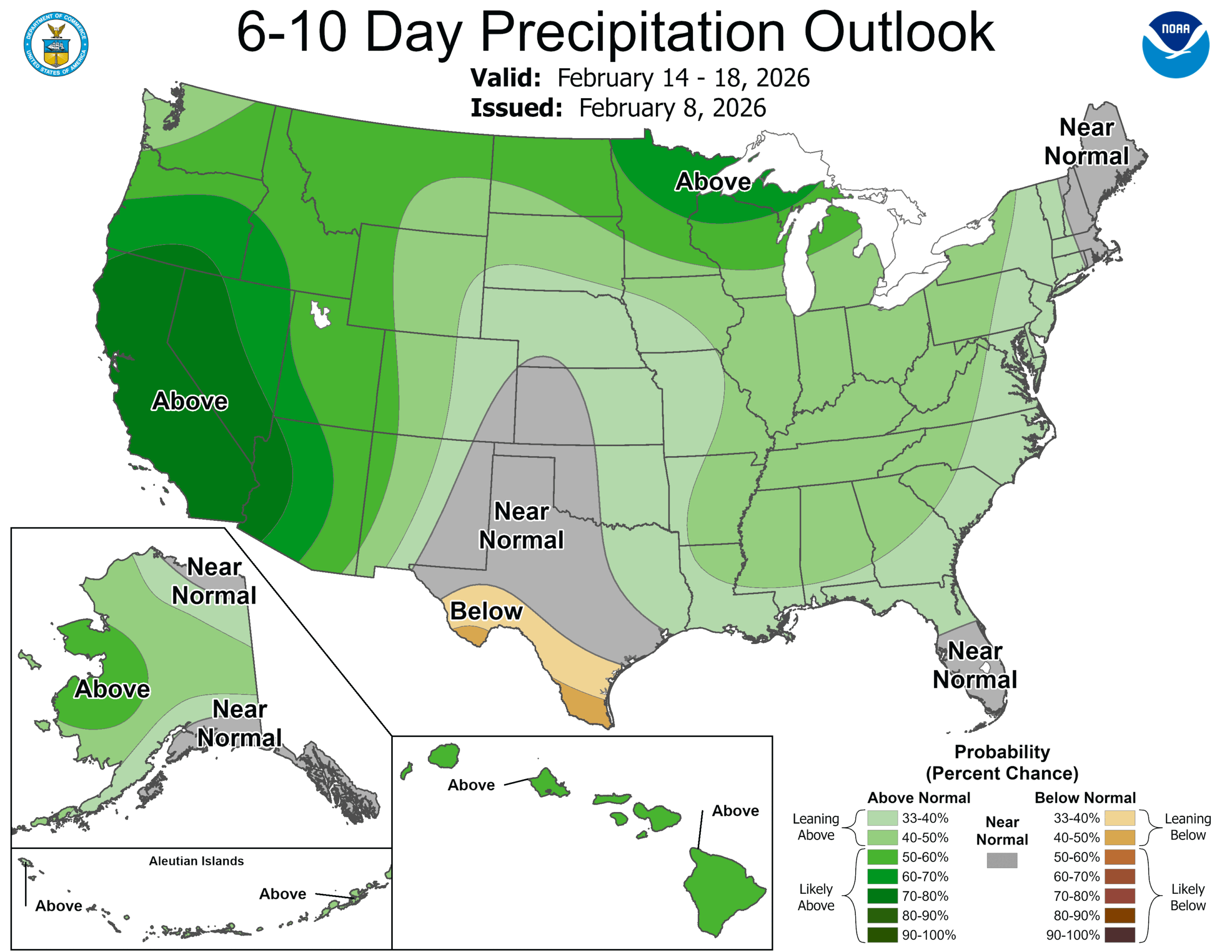
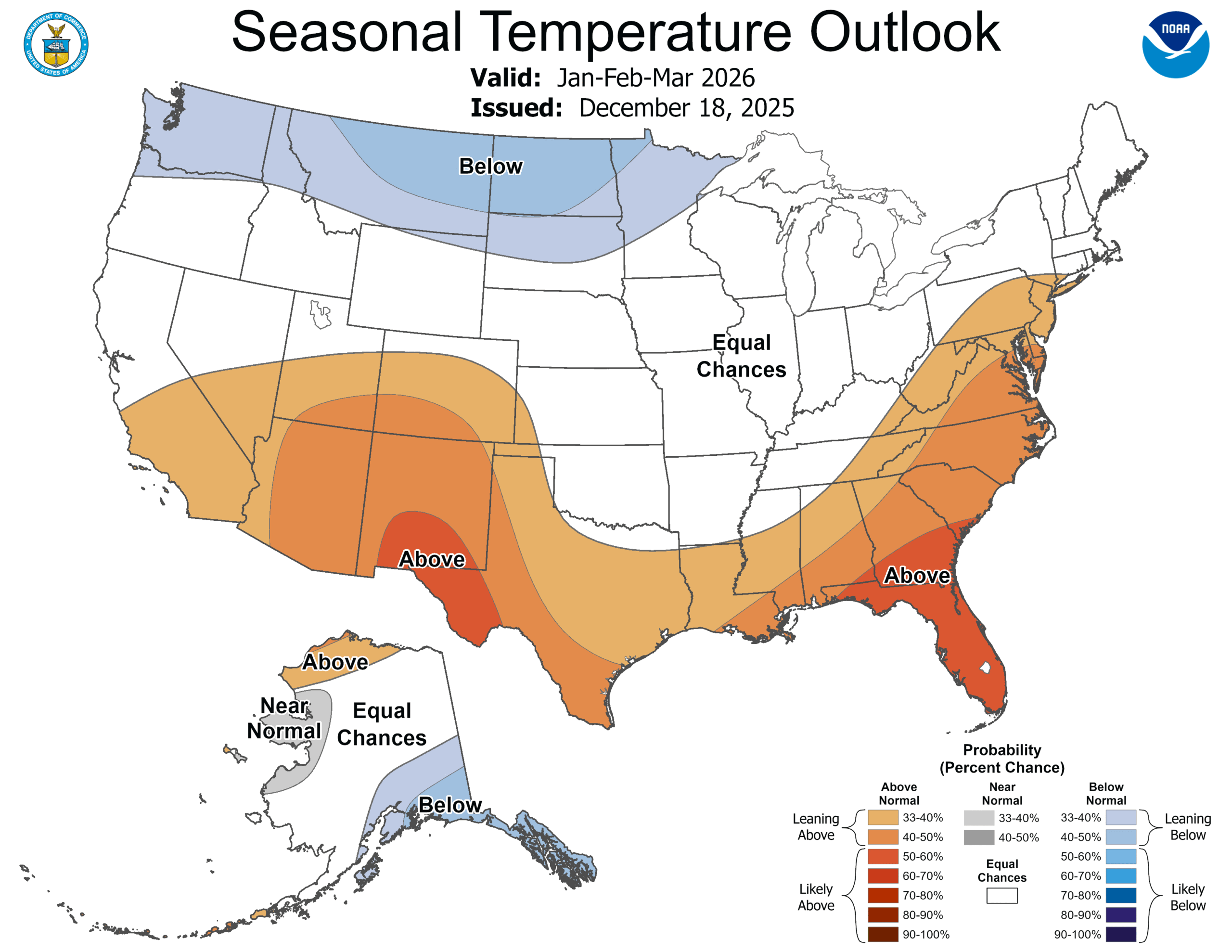
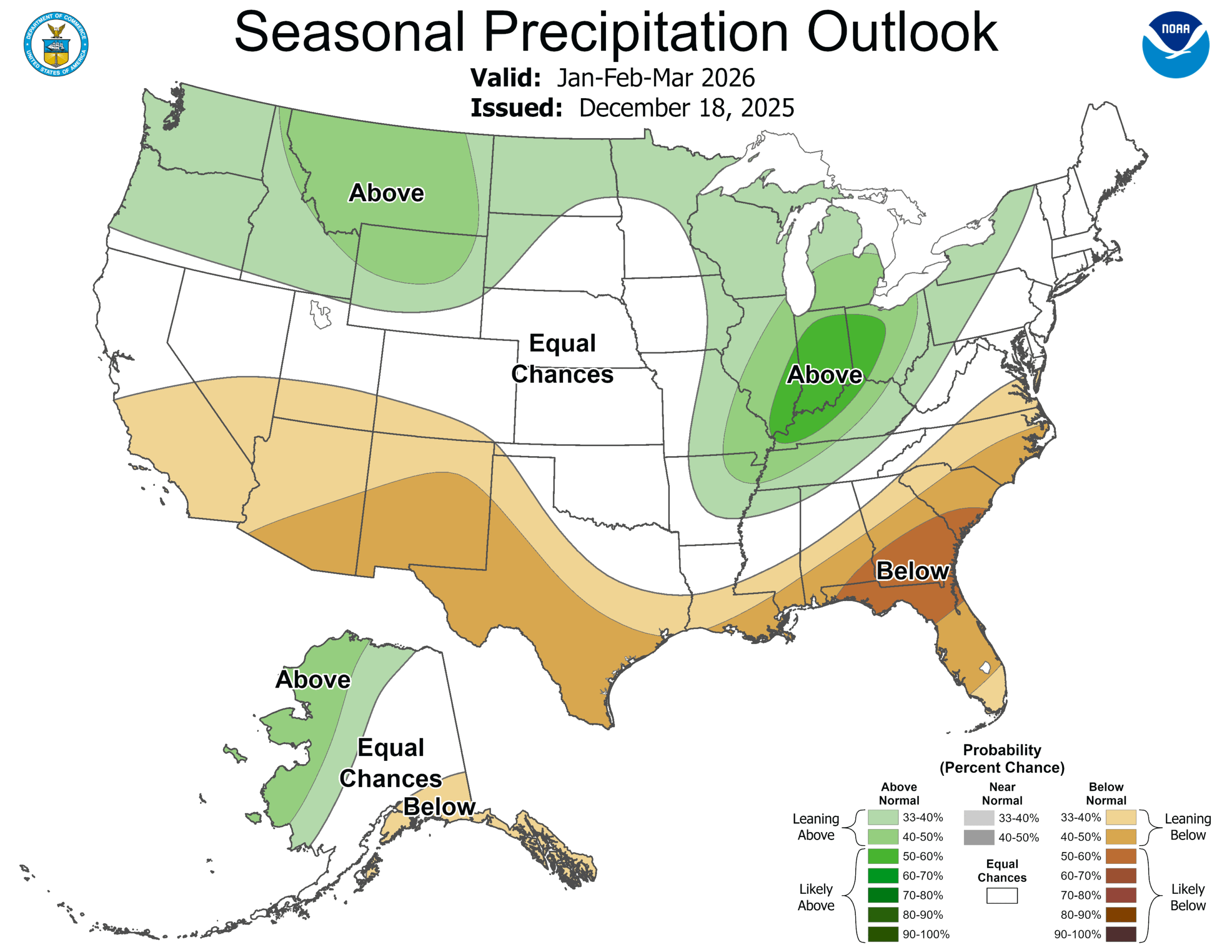
In the winter, that means that snow is in a deficit. The way to build that snow pack back up is A) through precipitation, and B) through temperatures remaining cold enough for the snow to generate. For one part of the country, at least, there appear to be the correct ingredients, and it may slake the thirst, at least for a corner of the country. Lets look at the CPC outlooks for both temperature and precipitation.
It looks to me like nearly everyone that expects snow this time of year is going to be in for a healthy dose through March. In particular, the northern Rockies will get to combine below normal temperatures and above normal moisture. Montana ski season is on, baby!
Also of note is the bullseye of above normal precipitation for Indiana. This region is one of the driest in the country right now, and a good drink through spring will do wonders. This part of the world is also cold enough to see snow in the winter, and with the forecast for near normal temperatures, they could certainly see some of this precipitation as a healthy dump of snow.
If you are one of the people that likes snow, then you probably do live in this snow zone, which means the forecast is good news. The snow is coming, just hold on.
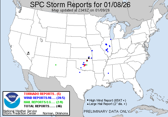
We made it a full week before we had a severe weather day here in the US, but our luck has run out. An area of low pressure moving through the Plains started generating severe weather, with a smattering of severe thunderstorm reports and a couple tornados in Oklahoma, including one that hit a farm in Purcell.
You’ll also note several severe storm reports in Illinois on Thursday. These were associated with the tail of a cold front tied to a deep area of low pressure moving earlier today through Labrador. The tail of that front also led to several wind storm reports today south of Rochester, New York.
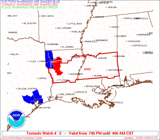
The real show is in the Lower Mississippi Valley. Low pressure dissipated after yesterday’s storms, but reconstituted over southern Arkansas late in the day. This redeveloped area is tapping into quite a bit of moisture, but also quite a bit of instability, and even now, there are tornado warnings and a tornado watch for northern Louisiana and southern Mississippi. These storms are rolling through overnight, which makes it a particularly treacherous scenario.
Fortunately, the system is moving quickly, which will allow it to occlude very quickly, and sap energy from the system. There is going to be a little bit of a carry over into tomorrow, particularly in the morning in areas like central Alabama, but the threat, fortunately, is going to be short lived. With a pattern as active and fast moving as it is, don’t be surprised for more quick hitter storms like this over the next couple of weeks.
We made it, at long last, to the end of 2025, and are hopeful for a 2026 that is safe and contributes wisdom and collaboration to our lives and discourse. One thing that will be added here, is in the verifications, the grade will no longer be a range, but will be based on a consensus – basically the average – forecast, and how it compares to what verifies.
2025 was an eventful year in America, from fires in California at the beginning of the year to the first EF5 tornado in a decade, ocurring in Enderlin, North Dakota, and on to this winter, where attention returned again to the Golden State, as snow and rain before Christmas led to impassable roads and severe flooding. We checked in with a few forecasts every month, but who was the top forecaster of the month?
The Weather Channel had a tremendous year, beginning to end. Often times when writing these recaps, plugging in the verification data and reviewing things month to month, there is a bit of intrigue as to who will be the top spot. Not this year! The Weather Channel was the most frequent forecast champion, sure, but not in a runaway. They were, however, always consistently near the top, and rarely had clunkers. As a result, they are easily the 2025 Forecaster of the Year.
Generally, when we have mentioned Omega blocks in the past, we have referenced them as the cause of heat waves and exasperating wind and fires in the southwest during the summer months. This winter has offered it’s own blocking pattern, and while it has been unusually warm over the Christmas Holiday, it has also brought about quite a bit of something else.
Precipitation. While the ridge in the middle of this block, like a Ω shape, the Greek letter Omega, gets a lot of attention, the winter has been all about the troughs on the west and east of the main feature. We discussed the rain that hammered Redding in our recent verification, but rain and snow has smothered California, with flooding and deadly consequences from San Francisco to San Diego. All of this was after the deadly flash flooding up around Redding.
The rain was heavy, certainly, but what really brought about the problems was the persistence of the pattern. The blocking ridge in the center of the country ensured that the seasonally omnipresent low in the Gulf of Alaska was able to funnel moisture to a low off the California coast, which made for a much wetter stretch than even California’s rainy season is accustomed to.
It isn’t all bad, of course. Anyone in tune with the economics of California knows that the snow in the Sierras is often the only moisture that the Valley will get through the summer months, supplying crops and thirsty residents. A large snowpack, while terribly inconvenient right now, will be a boon for regional agriculture this summer.
On the other coast, the trough has been a good environment for the development of low pressure in the Gulf Stream. This has enhanced some clippers moving out of the Canadian Prairies, as well as more localized development, both features contributed to the travel hassles along the coast over Christmas. The continued winter storm warnings for Lake effect snow in the Great Lakes are all ongoing because of a feature that has rotated and become embedded over Hudson Bay.
For the foreseeable future, this is the outlook. The Plains and particularly the Front Range will remain quite warm. As with most Omega features, even ones in the winter, the West Coast will remain above normal as well, given flow moving down from the mountains when the low pressure off the coast ebbs. Throughout all of it, look for above normal moisture nearly nationwide to start the new year.
I think we have all been here long enough to see what outlets we expect to rate near the top of the heap in most months, and which are going to be a bit further down in the pecking order. The Weather Channel, the Weather Service and Accuweather (along with Victoria-Weather sometimes) are typically near the top, so it is a real underdog story when another outlet grabs the title. This is one of those months. Weatherbug was the top forecaster of the month, despite having had the toughest go of it for the first 10 months of the year.
We are arriving in one of the busiest travel seasons of the year, as millions of Americans will travel over the river and through the woods to Grandmother’s house. The great news is that most of the winter weather that is forthcoming is steering clear of the major airports. A shortwave will be pulling out of the southern Plains and headed for the mid-Atlantic by Tuesday afternoon but this will bring primarily rain and maybe a low cloud deck, both problems for flight operations.
But rain and clouds aren’t a disaster, as the clouds and visibility won’t be as low as they would be with a snowstorm. Any weather delays are likely just going to be secondary to the volume and other issues that arrive at airports. It will be slow in some important areas because of the rain, but not a disaster by any stretch of the imagination. I’m talking about New York, Philadelphia and Washington, reaching parts of coastal New England on Wednesday. By Thanksgiving, it will be clear and crisp up and down the Eastern Seaboard.
Fortunately, the threat for snow isn’t going to be a problem for most of the country, especially air travelers. Unless, of course, you are going to northern Minnesota. The occluded portion of the feature that will be responsible for the rain out east is also responsible for winter weather alerts from Montana to the UP of Michigan. The heaviest stripe of snow will be in Northern Minnesota, and should be wrapped up by midday on Wednesdsay.
This isn’t a ton of snow, and the roads that it impacts aren’t well travelled. There won’t be volume issues in Bismarck or Duluth or Rhinelander, some airports that will see some of this snow. Lake effect snow will become a problem on Thanksgiving, so Cleveland and Buffalo are going to be tricky for day-of traveling, and perhaps returning home on Friday as well.