What was presently evaluated to be an EF-4 tornado swept through western Mississippi on Friday evening, striking Rolling Fork and Silver City. The cell continued and another tornado struck near Winona at an EF-3 rating. In total, these tornadoes were responsible for the deaths of at least 20, most of whom were from Rolling Fork.
The Jackson, Mississippi NWS office is among the best in the country, in my pinion, and they were well ahead of this storm. There was a tornado emergency issued for Rolling Fork and Silver City before the storm struck, with ample advanced warning. Rolling Fork lies well removed from other large population centers, in an impoverished part of Mississippi, and the ability for the message to be disseminated, and the swiftness of emergency response may be factors in the elevated death toll.
Undoubtedly, the structural integrity of many of the building in Rolling Fork, Silver City and Winona were factors, and the strength of the tornadoes themselves absolutely cannot be discounted. This storm, like so many before it, however, underscore the systemic issues that can increase the lethality of a system, and emphasize how important it is to have a plan for severe weather before it is on your doorstep.
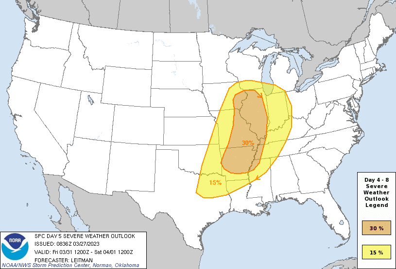
With that in mind, there is certainly more rough weather on the horizon as we get deeper into springtime. The SPC is already monitoring Friday the 31st for a significant severe weather outbreak. They highlight a large tract of the country straddling the Mississippi, and I would, at this early stage, be particularly interested to see how the situation evolves around the Bootheel of Missouri.
The storm is going to be reflective of so many that have struck this winter. A deep diving trough will initiate rapid cyclonic development in the southern Plains, lifting north towards the western Great Lakes. Vorticity within the feature will lead to a tornado threat within the northern part of the storm, though strong wind and some hail are going to be an issue as well.
If you are in line for this severe weather, it’s time to have a plan. Even if this storm might leave you unaccosted, with severe weather season coming for the country, it’s a good idea for all of us to start considering what we will do in the event of a life threatening situation.