We’ve reached the end of summer, and with it, the peak of hurricane season. With that in mind, expect some lighter site forecasting, and a bit more “big story” coverage for the next couple of weeks.
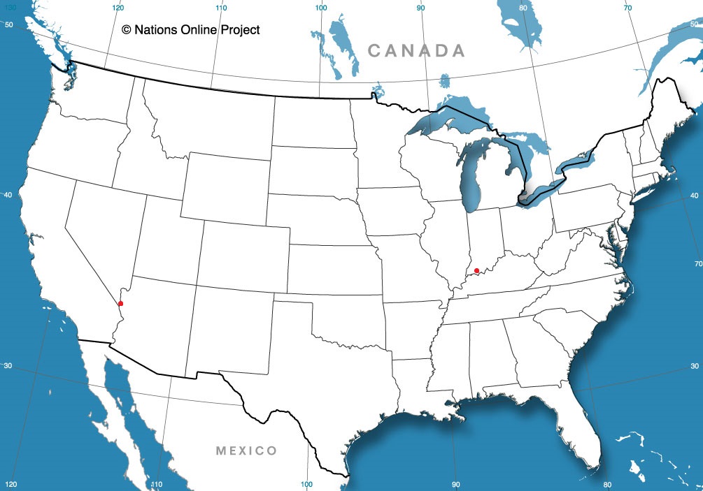
Lake Havasu City, Nevada
Evansville, Indiana
from Victoria-Weather

We’ve reached the end of summer, and with it, the peak of hurricane season. With that in mind, expect some lighter site forecasting, and a bit more “big story” coverage for the next couple of weeks.
Lake Havasu City, Nevada
Evansville, Indiana
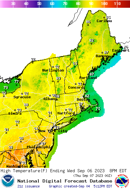
Hot weather is roasting the middle of the country on this Labor Day, but it’s going to break, at least in the northern part of the country thanks to a round of severe weather moving through the Upper Midwest. The peak of the heat for New England looks like it will come on Thursday of this week. Below are the highs for Thursday
By now, I’m guessing many of you have assessed the forecast ahead of Labor Day as you make your holiday weekend plans. I hope it includes a pool, cold drinks or plenty of air conditioning. Not only is it expected to be warm, but expect record breaking heat through the center of the country. Here in the Twin Cities, triple digits aren’t out of the question.
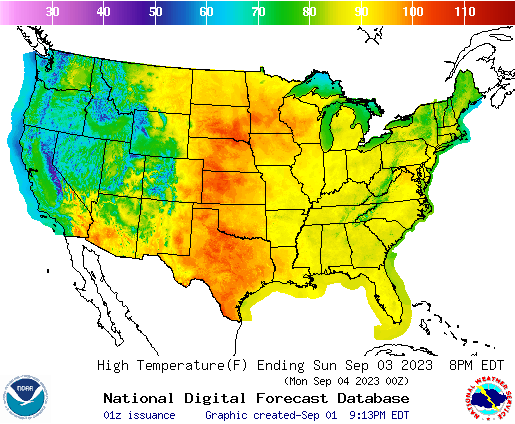
While it will be a blast furnace from Wisconsin to the Dakotas and south through the Plains, it will be much more comfortable on the coasts, except, I should note, around the DC/Baltimore area, where it’s going to be abnormally warm as well.
After the weekend, the heat will ease a little bit, but it’s still going to be danged hot, especially for the areas surrounding west Texas. Note that the heat is also going to arrive in New England and the Mid-Atlantic.
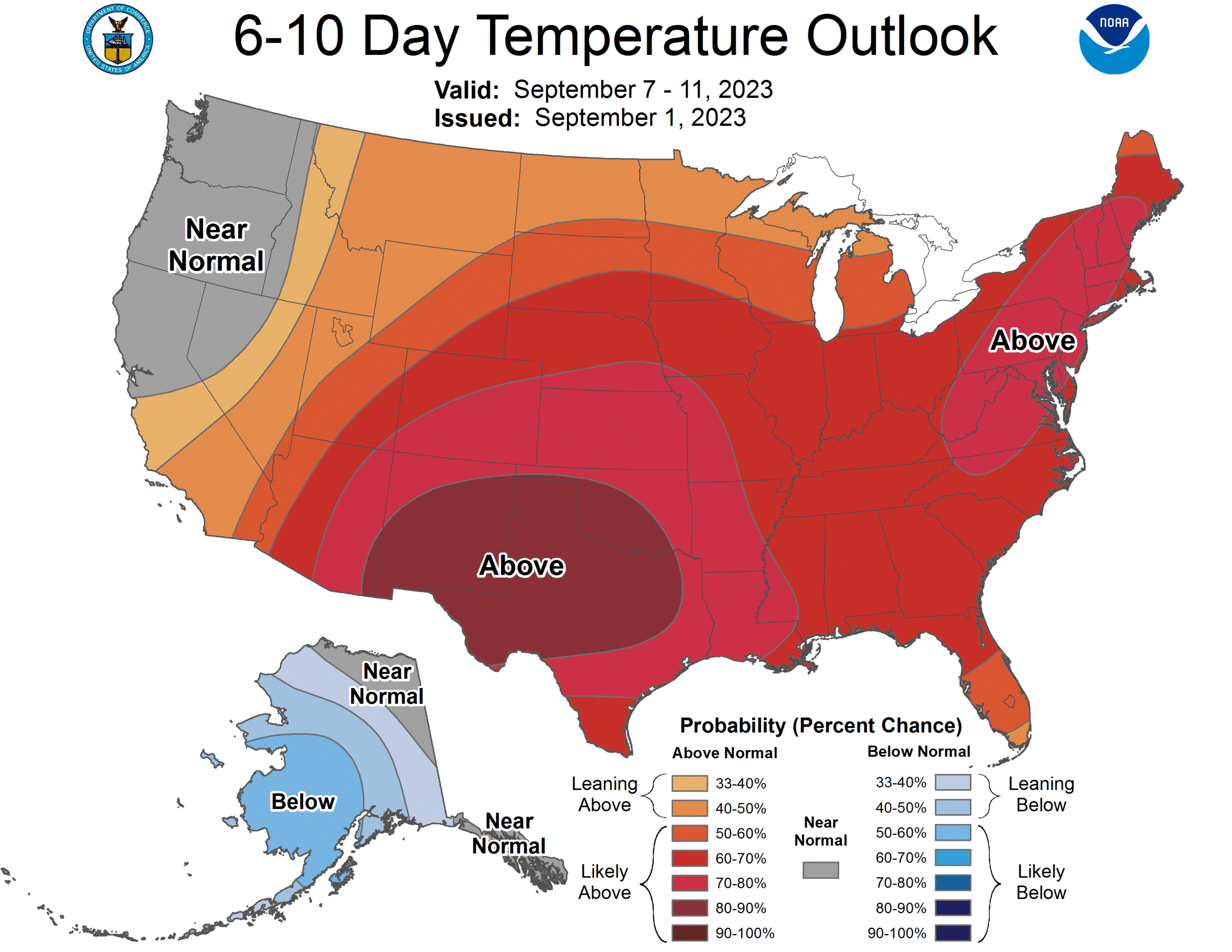
The rest of the month, after the 7th-11th looks to mostly temper. but still fairly warm. One bit of good news is that it looks wetter than normal in the Plains, which will stymie any growing drought concerns in the Plains.
We’re marching on through summer, and after failing to mention the top outlets last month, we get a twofer here in August. Weatherbug was the top outlet back in June, a notion belied by their position near the bottom of the Forecast Wins chart. Still, that’s the chart for the year, and one strong set of forecasts can earn you the month, like it did for Weatherbug in June.
With more work done in July, we were able to see an outlet with a stronger win total actually claim the title for the month. In the first month of the second half of the year, the title was claimed by those stalwarts at The Weather Channel. They also scooched on up the Forecast Wins total, but they moved in to 2nd place, which is more impressive than Weatherbug’s second to the bottom.
Congratulations to both of our winners, and to you, for having so many good weather providing options these days.
| Outlet | Forecast Wins (year) |
| Victoria-Weather | 5.33 |
| The Weather Channel | 3.33 |
| Clime | 2.83 |
| National Weather Service | 2.5 |
| WeatherNation | 2.5 |
| Weatherbug | 2 |
| Accuweather | 0.5 |

If ever there are months that you want some forecasting consistency, they are the spring time months. Every forecast we had in the month had a combined winner, which suggests that we got that in May. Still, Accuweather was a hair better than the rest, and were able to attain the title of Forecaster of the Month for themselves.
| Outlet | Forecast Wins (year) |
| Victoria-Weather | 3 |
| Clime | 2.5 |
| National Weather Service | 2.5 |
| Weatherbug | 1 |
| The Weather Channel | 1 |
| WeatherNation | 0.5 |
| Accuweather | 0.5 |
Memorial Day is the unofficial kick off to summer for a lot of people. There is only about a week left of school, give or take, for most people, June is around the corner and even the most northerly spots in the United States would be rightfully upset if they saw snow. Still, late may and early June in the Upper Midwest is usually in the mid 70s for a high. Warm, for sure, but not sweltering.
This version of the earliest stretch of “summer” features a blocking pattern in the center of the country. A temporary pulse down in the overall flow into the ridge is allowing a bit of progression for the pattern. This means that on the western side of the ridge, there is room for the trough to lead to surface development.
And if you are a long time reader of the site, my book, or just a first timer generally knowledgeable of things meteorological, you will know southerly flow precedes low pressure, and that means a hot, humid warm up for the middle of the country. In fact, for the next week, most of the north central US will be double digits warmer than normal.
Low pressure at either coast, including the one driving warm air north, are keeping temperatures below normal in California and the mid-Atlantic, while the fact that it is just generally hot already this time of year along the Gulf Coast are dampening some of the numbers there.
The hot, soupy weather will lead to some afternoon convection for much of this warm region, while surface features bumped up into Canada will ensure a little bit of extra convection later in the week in the Northern Plains and western Great Lakes. The calendar will say June, but it will fell like July or August for a few days.
Earlier this week, Supertyphoon Mawar swiftly intensified, then crashed through Guam as a Category 4 storm, the strongest in memory for the US dependency. Damage is extensive, power is out to the island and the recovery will be long and hard. Two men lost their lives, which is tragic, but also a lower figure than one might have anticipated. Mawar only strengthened after passing over the Mariana Islands, but if forecasts are accurate, Mawar will not go down as one of the typhoons of legend in the western Pacific.
There is some model consensus on Mawar’s future. An area of low pressure is expected to move out of eastern Mongolia and northeastern China, across the Korean Peninsula and into the north Pacific. It will drag a cold or stationary front westward and south through China. This will have an effect of bringing Mawar to a full stop, northwest of Luzon in the Phillippines and east of Taiwan, two major population centers.
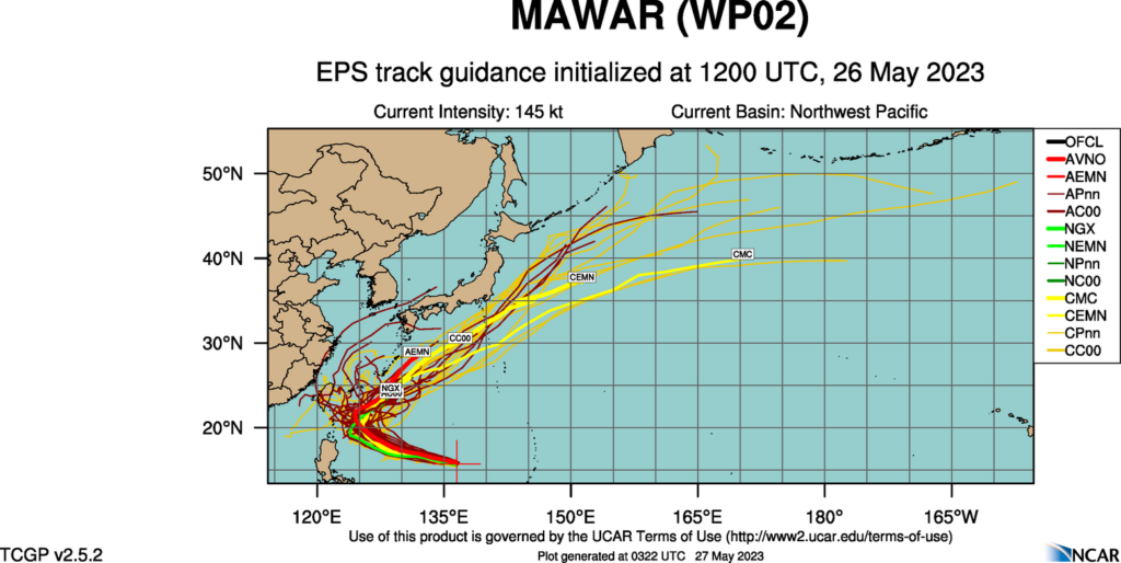
Mawar will still get close enough to both islands to bring high surf and the portential for a little storm surge, especially given the proximity suggested by some models to Taiwan, but we aren’t expecting a direct landfall of this strong storm on either. Then, as Mawar weakens, it will turn north towards, but ultimately southeast of the home islands of Japan, another crisis averted.
That certainly isn’t to say that Mawar will be totally unimpactful after Guam. The storm will move swiflty through the Bonin and Volcano Islands, the most famous of which for Americans is Iwo Jima, which is presently uninhabited. There are also important shipping channels that will be disrupted while the storm churns between all these commercial venues.
There is plenty of time for the tropical season to take a more sinister turn, but for now, we tentatively have had a stay.
So many years in a row, we’ve been talking about premature tropical storms, or the ongoing western drought. This season, if there are any major stories, they are of the short lived, spring tornado variety. You know, the type of scenario you would expect if you’ve studied American climatology.
A robust snow season led to considerable concern for a massive flood season, especially in the Upper Midwest and further south through the Mississippi Valley. Fortunately, despite all the snow that the Dakotas and Minnesota saw this season, Iowa saw very little, and instead of aggregating, the threat for downstream flooding withered away. There was flooding in typical spots in the Upper Midwest, but nothing that was particularly overwhelming. Places that are often underwater were once again underwater for a couple of days.
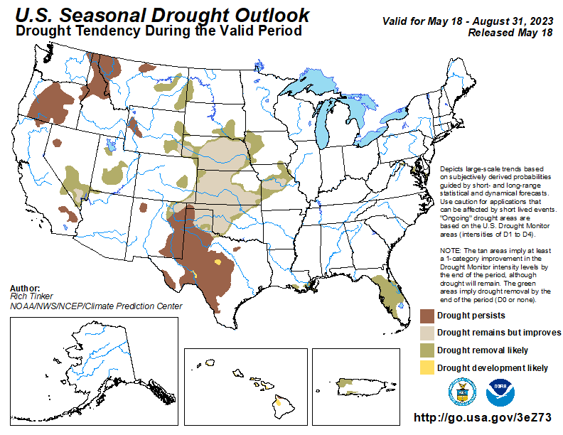
The heavy snow also afflicted the Sierras in California, and while the melting of the season did fill some reservoirs and watery spots that aren’t accustomed to be watery, the snow really served as a net positive, scuttling years of drought, and rescuing the local agricultural economy. In fact, there isn’t even a forecast for drought to return this season. Its part of a nationwide drought recovery forecast this summary, and surely the most notable part.
There is nothing to say that the tropical season won’t be just as active as the forecasts call for either, but that activity had stretched outside of the early bounds of the normal Atlantic hurricane season multiple times in the last decade or so. There are only 10 days until the North Atlantic Season starts, and we still await our first A storm, and will likely wait until the season begins.
There are still plenty of weather stories to continue to monitor and keep your eyes on, but this season is a full reset on a lot of the major weather stories that started the 2020s. For now, we are back to “normal”.
April was generally cooler than normal for a large swath of the country, and for a long stretch of the time. Lets try to remember the month fondly, though. There was at least one week where the temperatures were in the 80s here in Minneapolis! And Clime can remember things fondly as well, as they were hot in the month of April as well. They secured the top spot for the month.
| Outlet | Forecast Wins (year) |
| Victoria-Weather | 3 |
| Clime | 2 |
| National Weather Service | 2 |
| Weatherbug | 1 |
| The Weather Channel | 0.5 |
| WeatherNation | 0.5 |
| Accuweather |
March was a heck of a month. May has a long history as one of the most tornado rich months of the year, but this month served as a reminder that tornado season starts as early as March. Deadly Twisters from Mississippi in the south to Illinois in the north were the major headline, but relentless blizzards and continued cold and flooding in the northern and western US were also factors in a wild month. Victoria-Weather tamed that beast, though, and we claimed the top forecasting month for March.
| Outlet | Forecast Wins (year) |
| Victoria-Weather | 3 |
| Clime | 1.5 |
| National Weather Service | 1.5 |
| Weatherbug | 1 |
| Accuweather | |
| The Weather Channel | |
| WeatherNation |