Wow. I’m not sure you could find a longer, flatter stretch of west to east driving in the country. We will see a great deal of prairie over the day and a half drive. We’ll cover 953 miles, which will be traversed over at a pace of 70.1mph, which might be the highest I’ve seen. That means day one will be through after 561 miles, or so.
DAY ONE (Sunday)
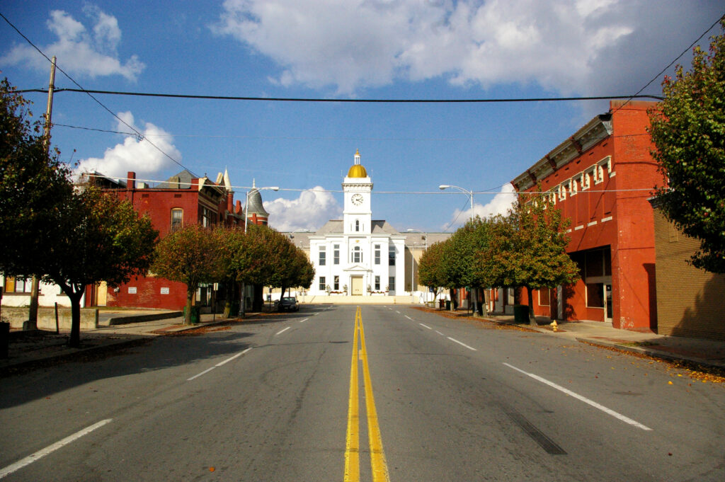
Pueblo, Colorado
There isn’t much to say for the day on Sunday. High pressure in the center of the country will keep things dry in the Plains, and unseasonably warm. There is going to be a bit of zonal flow across the Rockies, producing showers and overcast for the first stretch along the Front Range, but clear skies the rest of the way, where we will stop in Odessa, Nebraska, near Kearney, for the layover.
DAY TWO (Monday) It’s going to be a warm day for a late September drive, but otherwise uneventful, aside from maybe traffic and construction in Omaha and Des Moines. The directions should be pretty easy too. I-80 to the destination, and there it is.
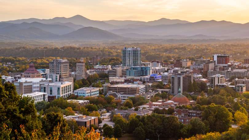
This drive is a short (for us) but beautiful drive from western North Carolina, and a city that is still recuperating from the impacts of Helene last year, to the capital of Virginia, a city that has been growing over the last twenty years. The towns are 372 miles and about 5 1/2 hours apart, and without a direct line between them. Nevertheless, we will still proceed at a rate of about 68mph.
Asheville, North Carolina
High pressure has built behind a cold front in the Appalachians. It will be a chilly day in North Carolina, but generally clear for the first part of the day. The cold air is riding the back of an offshore area of low pressure which will be near Virginia Beach as we head out on Wednesday. This low will cycle back moisture into the Coastal Plain, and starting around Middleburg, NC, we will start to see the chance for rain, which will stay with us the rest of the way to Richmond. Don’t be surprised if this rain is heavy at times. Bring an umbrella!
I have a NASCAR race on in the background, which makes me think that we can cover the 1,529 miles of this trip in no time. Really, though, let’s play it cool and instead make the drive in about 3 days, leaving the third day the shortest. and drive at a safe speed of 68mph, and about 547 miles a day. We will save our poor choices for Atlantic City.
DAY ONE (Monday)
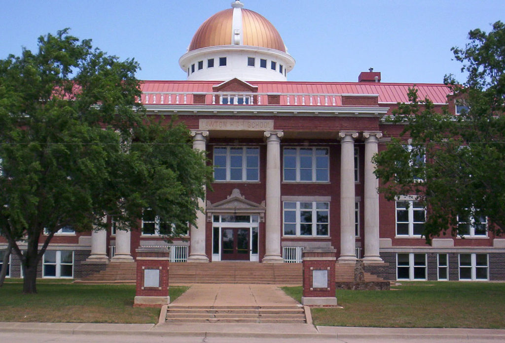
Lawton, Oklahoma
There is an eroding dry line that is washing out in the central Plains. This is producing some showers from about the Oklahoma City area to Springfield, Missouri, and there is no reason to think that this instigator will move much tomorrow. It likely won’t be as widespread as it is today. I would say the best threat will be in the higher terrain around the Ozarks, but should be fully wrapped up before we reach Sullivan, MO. Definitely before we hit Fenton, on the southwest side of St. Louis and our destination for the night.
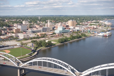
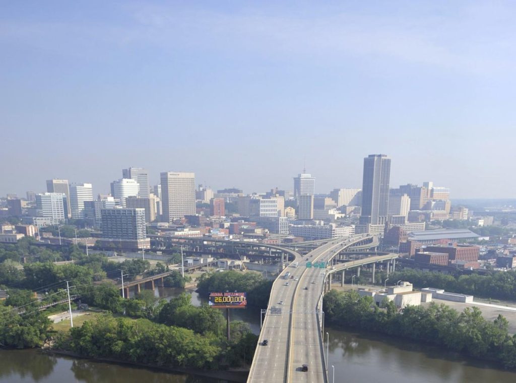
DAY TWO (Tuesday) Our weak trough is going to start to consolidate and turn around over night. It’s going to shift towards the Tennessee Valley, which should keep it juuuuuust far enough south to keep us dry for the day. There will be a few dark clouds dappling the sky as we continue east, and they will probably linger thorughout the day. Aside from maybe a sprinkle early in the morning as we pass through St. Louis, I think we are probably OK. The best bet for another shot of rain, albeit low, will come in the last couple of hours, from Columbus to Bannock, which is just outside of Wheeling, and our destination for the night.
DAY THREE (Wednesday) That same trough will waste itself on the Appalachians and spread along the range. There will be some splashes of rain, particularly on the western faces of the range for the first part of the day. We’ll have rain through about Bedford, after which point the weak system will have a tough time transcending the Appalachians. The sun will be shining in Atlantic City when we pull in.
This drive has all the elements of what I think makes a good road trip. It will take one long day, following only a couple of interstates. There is one major metro area to drive through, but also a long stretch in the open country. It will take nearly 10 hours to cover the 658 miles between our two destinations, covering the ground at a pace of 66.2mph. Hopefully traffic in Dallas-Fort Worth is forgiving.
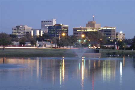
Pine Bluff, Arkansas
Arkansas is going to be downright juicy on Thursday. Humidity will see dew points in the mid to upper 70s, and while guidance suggests most of the rain and thunder will be from Mississippi eastward, I wouldn’t rule it out during our drive to Texarkana. In fact, I would venture to say that the heavy atmosphere might lend itself to a stray storm as far west as Mount Vernon, Texas. The dew points will relent a bit west of Dallas, but the heat will still be there all the way in to Midland.
We are headed towards the middle of the country, on a drive that will spend quite a bit of time on I-80. It will take 4 days to cover this ground, because America is a big country. Expect a pace of about 69.4 mph, which is pretty great, actually. Hopefully, the weather will cooperate as well.
DAY ONE (Thursday)
Modesto, California
There is some signal that there will be an active monsoon, spreading as far west as the Cascades and northern Sierras. Not really the monsoon, I guess, at that point, but it will follow a similar diurnal pattern. I wouldn’t expect it to occur far enough or early enough in California to be a concern, and the drive through Nevada will be generally featureless, both with the weather and the man made structures. The day will end in Welcome, as we approach the Utah border.
DAY TWO (Friday) The monsoon will make more sense on Friday, following the Front Range in Colorado and Wyoming, which we will approach on our second day on the road. We’ll make it to the Akal rest area west of Laramie, and we may see a spot of rain at the end of the day. Nothing overwhelming, surely, and definitely not anything that will substantially slow us down.
DAY THREE (Saturday) The impulse coming away from the front range, the one that we approached at the end of our Saturday drive, will lurk through central Nebraska for much of our Saturday drive. There will be patchy clouds, some spots of rain, heavy at times, and an isolated thunderstorm. We will take our turn off of I-80 in Lincoln and make it to Palmyra for the night. By that point, those showers and storms should be ramping up, and we may be in for quite the stormy evening.
DAY FOUR (Sunday) I didn’t realize when I was looking ahead to this forecast that we were spending none of our time on Sunday on I-80, and in fact, very little of our time will be on an interstate. We will make it across northern Missouri on US 36, but we will leave the weather in Nebraska (and maybe a bit in Iowa). The trough bringing storms to Palmyra will stall and provide some steadier rain for the eastern part of the Cornhusker state. By the time we have reached St. Joseph and turned on to 36, we will have reached the end of the precipitation for our journey. We will cross Missouri in mostly sweltering sunshine before crossing the Mississippi in Hannibal and finally slicing through the heart of Illinois to reach our destination in Danville. It will feel summery to end the weekend.
We’ve made it through the Holiday weekend, and are ready for wherever the road may take us. In this case, it is taking us to Arkansas. The drive will last 12 hours, the longest we are allowed to travel in one day during these trips, and we will cover 863 miles. On average, that is a pace of almost 72mph. Hard to stick your nose up at that.
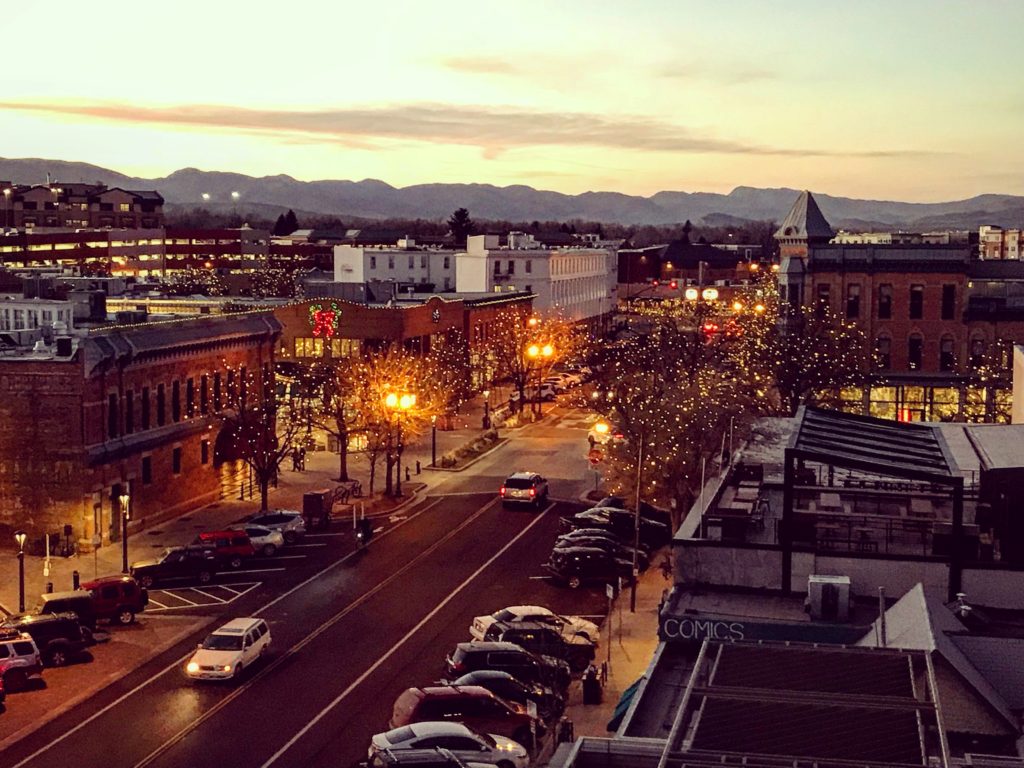
Fort Collins, Colorado
This afternoon, a weak trough sweeping through the Front Range will touch off an area of thunderstorms in the Canadian Prairies, moving towards western Kansas. This will ensure that the atmosphere settles out a bit as we start out on Tuesday. We’re going to see sunny skies in Colorado and western Kansas, but will eventually reach the back end of the instability around Wichita. The bulk of any moisture or storm activity will be seen in Missouri, and we are going to be swinging south through Oklahoma. There will be some lare storms in northern Oklahoma, but by the time it really fires up, I suspect we will already be waiting in Fort Smith when it gets more showery in Oklahoma and across the border in Arkansas.
We are taking a two and a half day drive through the western US on this occasion. Expect heat, undulating terrain and a pace of 67mph, or so, with a daily goal of 537 miles. Driving in California is a challenge of it’s own, so we can plan a half day drive in the Golden State. Westward, ho!
DAY ONE (Wednesday)
Pueblo, Colorado
It’s getting busy in the Plains, with showers and storms offering quite a bit for storm chasers to enjoy. The storms usually show up in the afternoon and north of the Palmer Divide lately, and neither of those will apply to our time in Pueblo. In fact, eastern Colorado is looking at a respite from the stormy conditions on Wednesday, so, if anything, it might just be a bit dusty. We will head first south to Albuquerque and west to Petrified Forest National Park, all without a drop. It will be a beautiful drive, and undoubtedly a bit on the warm side.
DAY TWO (Thursday) If the desert heat doesn’t much bother you on Wednesday, I have a guess that it may on Thursday. We will drive through the heat of the Mohave (in fact, stopping in the town of Mohave for the night) after getting out of the higher terrain of Arizona. Low pressure is setting up a bit in the Rockies, so there could be some light wind, but really, it will be fairly tame as compared to what it usually is (it will be around 100). Your tires aren’t going to melt.
DAY THREE (Friday) The rise and fall of our drive through the Coastal Range will be the real climate winner for the day. Temperatures will drop to something more tolerable, chilly, even, when the wind is up. Monterey bay will be serene, and we will enjoy our time in Santa Cruz.
It’s a two day trek through the Plains between Jonesboro and Pueblo. We will cover 891 miles at a pace of a mere 61.1mph, of which very little wll e on the interstate. The first day will conclude after about 489 miles of motoring. This feels like a drive that should be done in an old pick up, doesn’t it?
DAY ONE (Thursday)
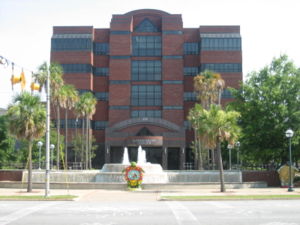
Jonesboro, Arkansas
I’ve recently been to Jonesboro, and it is a nice little town. It was a bit on the rainy side when I visited a few years ago, and it will be more of the same as we head out on Thursday morning. A bit of an upper level trough will help open up the Gulf, with moisture tracking through the lower Mississippi Valley. The northern terminus of rain shower activity will mirror our route. Showers will be off and on throughout the day, and we will reach the western edge of the rain fall activity by the end of the day, between Wichita and Hutchinson in the town of Haven.
DAY TWO (Friday) All of this activity is going to be swept up and way towards the Ohio Valley, and ready to spend the weekend in New England, where all precipitation spends it’s weekend. This will give us a lovely, unaffected drive through Kansas. A bit of a lee trough is going to start cycling some air as we approach Pueblo, but it won’t impact us in terms of precipitation, instead producing some orographic thunderstorms in Wyoming, near the Sand Hills of Nebraska. No problem in Pueblo!
We’re headed through the southern part of the country today. Well, for the next three days. It’s nearly a straight eastward shot covering 1758 miles. The pace will be 67.6mph, which means a pace of about 541 miles a day for the first two days, with a longer drive coming on the third day. We’re leaving from the desert, so that 10 hour drive will also happen to coincide with the most interesting weather as well.
DAY ONE (Sunday)
Tucson, Arizona
It’s time to hit the road on day one of our southern road trip, and as one might expect, the drive through the Desert Southwest is going to be pretty dry. Arizona and New Mexico, all the way to El Paso are going to be pretty dormant, however as the evening approaches, the dry line in west Texas is going to start looking a little more active. Maybe storms won’t fire as far south as I-20, but I wouldn’t rule it out. The real question is, will they fire far enough west for us to reach them on Friday night? Also not likely, but I wouldn’t rule it out. Let’s stop in Barstow, just past Pecos, for the night.
DAY TWO (Monday) Saturday will be spent entirely within the state of Texas. All eyes will be on an area of low pressure in the northern Plains that will be making for very spicy weather way up there. In Texas, the return flow will be churning through Texas as things continue to bubble up in the Dakotas. For our purposes, that means scattered clouds throughout the day, and an increasingly unpleasant humidity as we make stops for gas. The threat for rain will be fairly low, however. We will make it to Kilgore, Texas, which is just to the southwest of Longview, for the night.
DAY THREE (Tuesday) It’s going to be a long day of driving just north of the Gulf shore. The system will be continuing in the northern US and will have a more typical cold front draped through the Tennessee Valley. This indicates a decent return flow across the Gulf, meaning heat and humidity will return, but beneath high pressure. This may allow some more low clouds and fog along the parts of the route that are a little closer to the water. Albany will be hot and muggy, just like you expect it to be in South Georgia.
It’s getting warmer which means it is getting closer to road trip season. This three day trek might follow the 1,797 mile path of someone returning from spring break. We will average 66.5 miles an hour and 532 miles a day, though we are really going to pack it in — 11 hours — on Saturday.
DAY ONE (Thursday)
Lake Havasu City, Arizona
This drive is one of beauty if you are just there to enjoy the scenery, as the sun will be shining, but as this is a weather blog, it may not offer the excitement we are hoping for. Alas, it is the Desert Southwest, and you get what you pay for. It will be a bit more interesting if you take in the entirety of the region, however. Low pressure in the Gulf of Alaska and a festering system in south Texas will squeeze our route, even bringing some clouds towards Albuquerque as we conclude our first day, though I-40 will stay clear.
DAY TWO (Friday) That sluggish feature in south Texas is going to start wandering east, and remain out of our path, but we would be wise to note what is causing this wander. A strong area of low pressure emerging in the lee of the Rockies will start directing traffic across the Plains, and will bear watching all weekend. Our trip to Oklahoma City will be pretty uneventful, however, which is a nice thing to say when severe weather looms.
DAY THREE (Saturday) It’s not going to organize terribly quickly, our large, troublesome area of low pressure. This means we don’t need to worry about a severe outbreak during our drive, but we will some isolated showers east of Rolla, MO, and more scattered showers and isolated thunderstorms north of Springfield as we get closer to the center of the system. Rockford will probably have rain, if not when we arrive, then soon.