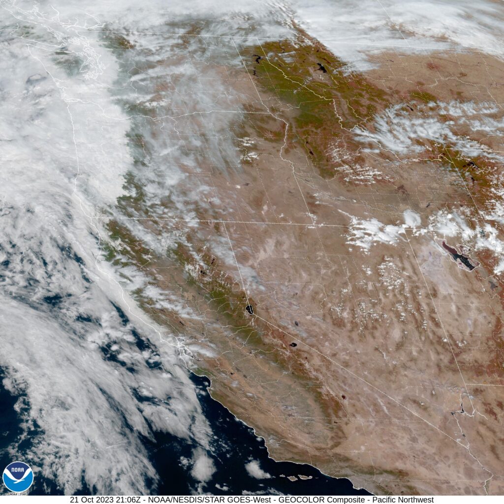
Victoria, Texas

Victoria-Weather is forecasting for Victoria, Texas, and one might wonder if we have a home field advantage. I can assure you that we do not. Victoria-Weather is named after my home town of Victoria, Minnesota. Slightly different climates.

At 1051AM, CT, Victoria was reporting a temperature of 64 degrees with clear skies and a brisk northerly wind. This will surely keep temperatures cooler for the Gulf Coast this morning. the wind is based on a surface flow, however, and high pressure is blanketing the middle of the country. Flow aloft is fairly stagnant, and cold air will not be actively imported as winds start to subside this afternoon.
A weak, quick hitting trough is developing in the lee of the Rockies, and will be moving northeast towards the Upper Midwest. The flow in the region will not alter much, thanks to sluggish jet flow in the region, but Victoria may see a little bit of a rise in humidity as the Gulf opens to the feature to the north.
Tomorrow – Mostly sunny, High 75, Low 49
Wednesday – Warner, a bit stuffier, High 81, Low 56

TWC: Tomorrow – A mainly sunny sky. High 77, Low 45
Wednesday – Mainly sunny. High 85, Low 53

AW: Tomorrow – Pleasant with plenty of sunshine High 77, Low 41
Wednesday – Plenty of sunshine; breezy in the afternoon High 84, Low 49

NWS: Tomorrow – Sunny, High 76, Low 46
Wednesday – Sunny, High 82, Low 53

WB: Tomorrow – Sunny, High 73, low 48
Wednesday – Sunny, High 82, Low 55

WN: Tomorrow – Sunny, High 76, Low 45
Wednesday – Mostly sunny, High 82, Low 53

CLI: Tomorrow – Sunny, High 76, Low 45
Wednesday – Sunny, High 83, Low 53

Those are some chilly morning lows for as far souh as Victoria is. The clouds over the Gulf certainly depict the vigorous off shore flow that is being observed. The rippling of the clouds parallel the coast, with nothing on land tells the story.

Racine, Wisconsin

Racine is nestled between Chicago and Milwaukee as part of the well populated stretch of lakeshore around Lake Michigan. It’s going to be a rainy couple of days for a lot of people. Is Racine going to be one of those locales?

At 1153PM, CT, Racine was reporting a temperature of 56 degrees with overcast skies. There was a smattering of rain showers moving west to east through northern Illinois, with some showers spilling north into Wisconsin. The coverage of rain in southern Wisconsin will only increase, as the rain is associated with a long, ranging warm front extended from a deepening system in the Plains.
Racine will exist in the warm sector for a brief time after the warm front passes through Thursday evening, and before the cold front arrives around midday on Friday. The front will potentially bring a bit of severe weather to Chicagoland, and I wouldn’t rule it out in Racine, either. The cold front will be gusty, and the tight rotation of the nearby low pressure could lead to some short lived funnels in the area. The primary concern, ultimately, will be rain, which will accumulate to several inches over the course of the storm, and depending on the intensity of thunderstorms.
Tomorrow – Rain early, ending late, High 57, Low 54
Friday – Rain and some thunder in the afternoon. Breezy, High 58, Low 52

TWC: Tomorrow – Overcast with showers at times. High 58, Low 54
Friday – Windy with rain likely. Potential for heavy rainfall. High 58, Low 54

AW: Tomorrow – Breezy with rain; the rain is much needed due to drought conditions High 58, Low 55
Friday – Windy with periods of rain, some heavy, and a thunderstorm; the combination of fallen leaves and rainfall can lead to slick roads High 59, Low 53

NWS: Tomorrow – Showers likely, mainly after 3pm. Cloudy, High 58, Low 52
Friday – Showers likely, then showers and possibly a thunderstorm after 2pm High 60, Low 54

WB: Tomorrow – Cloudy. Chance of light rain showers in the morning, then light rain showers likely in the afternoon. High 56, Low 52
Friday – Breezy. Light showers likely in the morning then rain showers and a slight chance of thunderstorms in the afternoon, High 55, Low 53

WN: Tomorrow – Windy with rain showers likely, High 58, Low 53
Friday – Windy with rain showers and scattered storms, High 59, Low 54

CLI: Tomorrow – Drizzle, High 57, Low 52
Friday – Drizzle, High 57, Low 52

Clime is really underselling this one, aren’t they? You can tell Racine is in for a grimy couple of days, with temperatures stuck in the 50s for 48+ hours. Here is the evening’s radar picture.

Bowling Green, Kentucky

Hey, weren’t we just forecasting in Indiana the other day? It will be interesting to see what can change in just a couple of days.

At 1053PM, CT, Bowling Green was reporting a temperature of 47 degrees with clear skies. The cooler regime that has embraced the Great Lakes and Ohio Valley in the wake of Philippe on the east coast has remained in place over Kentucky, an the clear nights will only serve to make things even chillier. Two features bear watching that will bring an end to the crisp weather.
The first is a strong fall system emerging in the High Plains, and the second is crossing Mexico. Hurricane Lidia, a Pacific storm will move through the northern Gulf towards the Florida Panhandle over the next 24 hours. The warm front associated with the High Plains system will drive warm air northward through Kentucky, but the remnants of Lidia will intercept any Gulf moisture before it reaches Bowling Green.
Tomorrow – Mostly sunny, High 74, Low 43
Thursday – Partly cloudy, High 79, Low 55

TWC: Tomorrow – Overcast. High 74, Low 43
Thursday – Sunny skies. High 82, Low 53

AW: Tomorrow – Nice with partial sunshine High 77, Low 44
Thursday – Partly sunny and warm High 82, Low 53

NWS: Tomorrow – Mostly cloudy, High 76, Low 44
Thursday – Sunny, High 79, Low 53

WB: Tomorrow – Mostly cloudy, High 72, Low 44
Thursday – Sunny, High 79, Low 53

WN: Tomorrow – Mostly sunny, High 77, Low 46
Thursday – Mostly sunny, High 79, Low 54

FIO: Tomorrow – Mostly cloudy, High 75, Low 44
Thursday – Sunny, High 82, Low 56

Clouds are encroaching from the south, but aren’t to Bowling Green quite yet.

Evansville, Indiana

Hey, look, it’s a forecast! After a lengthy time away from the site forecasts, let’s see if we still remember how to do this.

At 1154AM, CT, Evansville was reporting clear skies with a temperature of 72 degrees. The region was in some clear, dry air in the wake of a rainy cold front that moved through yesterday afternoon. Low pressure continued to spiral over Michigan, and it will be pressed northward as Tropical Storm Philippe heads towards New England. The thermal trough will swing south today and overnight, with tomorrow morning landing as the chilliest morning of the season, with Sunday being even chillier.
Philippe will merge with the Great Lakes low and start to occlude and retrograde. The persistent northwest winds will keep temperatures down, and the moisture continuing to wrap between the two features and slowly into Indiana. This will lead to some overcast throughout the weekend, and temperatures closer to autumnal.
Tomorrow – Mostly sunny, High 63, Low 44
Sunday – Mostly cloudy, High 64, Low 42

TWC: Tomorrow – Sunny. High 63, Low 45
Sunday – Sunshine and clouds mixed. High 66, Low 41

AW: Tomorrow – Partly sunny and cooler High 63, Low 45
Sunday – Plenty of sunshine High 67, Low 40

NWS: Tomorrow – Sunny, High 62, Low 44
Sunday – Mostly sunny, High 65, Low 40

WB: Tomorrow – Sunny, High 60, Low 45
Sunday – Mostly sunny, High 64, Low 44

WN: Tomorrow – Mostly sunny, High 62, Low 44
Sunday – Mostly sunny, High 66, Low 40

CLI: Tomorrow – Sunny, High 63, Low 45
Sunday – Partly cloudy, High 66, Low 43

This is what I believe many in the US would call football weather. There is a nice swath of sunny skies over southern Indiana today.

Lake Havasu City, Arizona

Lake Havasu City is probably one of the longest names for a a forecast site that we have. On the other hand, it’s position between Las Vegas and Yuma typically means a particularly brief forecast.

At 815AM, PT, Lake Havasu City was reporting a temperature of 84 degrees with fair skies. Dew points in the area were in the low 50s, though that isn’t terribly absurd for this time of the year, with the monsoon active. Most of the wet weather is at elevation, and will continue to be so in the eastern part of Arizona.
An upper level trough is on its way into the northern Rockies, which will reorient the regional flow. Cooler, denser air will be angled off the Pacific towards Lake Havasu City, and will have a difficult time reaching the area. Dew points are expected to drop, and the threat for clouds or spotty rain showers will disappear with the feature’s arrival.
Tomorrow – Mostly sunny, High 98, Low 76
Friday – Sunny, High 100, Low 80

TWC: Tomorrow – Sunny skies. High 100, Low 79
Friday – A mainly sunny sky. High 102, Low 78

AW: Tomorrow – Plenty of sun High 99, Low 79
Friday – Plenty of sun High 102, Low 77

NWS: Tomorrow – Sunny High 96, Low 80
Friday – Sunny, High 97, Low 79

WB: Tomorrow – Sunny, High 99, Low 77
Friday – Sunny, High 100, Low 78

WN: Tomorrow – Sunny, High 101, Low 79
Friday – Sunny, High 103, Low 78

CLI: Tomorrow – Sunny, High 100, Low 79
Friday – Sunny, High 102, Low 79

A little variety to the forecast in Lake Havasu City. I’m a little surprised that this is how it shook out. Satellite is clear in California, and getting clearer in Arizona.

Danville, Illinois

Danville is south of Chicago and snuggled up next to Indiana. The whole region is consumed by corn fields.

At 959PM, CT, Danville was reporting a temperature of 55 degrees with fair skies. Dew points were in the low 50s as well, and thanks to the looming harvest, the air around Danville was a bit moister, and will be prone to fog on clear nights such as today. High pressure is currently in place, while Idalia in the Carolinas had started to pull some cooler moisture from Canada towards the low, bringing some cooler air to Danville.
Temperatures will remain a bit suppressed while a wave moves just north of the Canadian border. Even though the system is bringing severe weather to the northern High Plains tonight, it will leave northern Illinois dry. After this feature shifts on, temperatures in Danville will really start to climb, just in time for the holiday weekend.
Tomorrow – Mostly sunny, High 79, Low 50
Friday – Sunny and warmer, High 85, Low 50

TWC: Tomorrow – Mainly sunny High 77, Low 49
Friday – Sunny skies High 83, Low 52

AW: Tomorrow – Plenty of sunshine; a nice end to August High 78, Low 49
Friday – Nice with plenty of sunshine High 85, Low 51

NWS: Tomorrow – Sunny High 78, Low 49
Friday – Sunny High 83, Low 51

WB: Tomorrow – Sunny High 76, Low 50
Friday – Sunny High 83, Low 53

WN: Tomorrow – Sunny High 78, Low 49
Friday – Sunny High 83, Low 52

CLI: Tomorrow – Clear, High 77, Low 50
Friday – Sunny, High 82, Low 52

The GFS was much warmer than all other models for Danville, and nearly every outlett abandoned that guidance. The warmth is coming, just a matter of when. Here is the satellite, with Idalia in the southeast corner.

Trenton, New Jersey

The intrigue right now is out west, where many are still contending with the issues brought out by a landfalling tropical storm over a desert. As is Victoria-Weather custom, we will end up forecasting on the other side of the country.

At 853AM, ET, Trenton was reporting clear skies and a temperature of 77 degrees. Fog was lifting in the valleys of eastern Pennsylvania, with clouds still lingering through the region, remnants of the moisture leading to the fog. High clouds indicated the jet running northwest to southeast through southern New England, with the moisture and heat in the Mid-Atlantic rising northeastward as a ridge builds from the Midwest.
Because the jet is so strong, the burgeoning heat and humidity in the Plains will not be able to build northeast towards the Mid-Atlantic. Instead, as the jet begins to break down, expect a little bit more air mass mixing, with cooler temperatures aloft merging with the soupy air in the south, bringing an increase of clouds for Trenton with some cooler temps by Thursday.
Tomorrow – Partly cloudy and warm, High 82, Low 60
Thursday – Mostly cloudy, High 78, Low 65

TWC: Tomorrow – Sunshine and clouds mixed. High 80, Low 60
Thursday – Showers in the morning, then cloudy in the afternoon. High 74, Low 64

AW: Tomorrow – Sunny to partly cloudy High 81, Low 59
Thursday – Mostly cloudy and cooler with a couple of showers High 74, Low 65

NWS: Tomorrow – Mostly sunny High 81, Low 58
Thursday – A chance of showers, with thunderstorms also possible after 5pm. Cloudy, High 77, Low 63

WB: Tomorrow – Mostly sunny, High 77, Low 62
Thursday – Cloudy with a 40 percent chance of showers, High 73, Low 67

WN: Tomorrow – Partly cloudy, High 81, Low 58
Thursday – Mostly cloudy with scattered showers, High 77, Low 63

CLI: Tomorrow – Partly cloudy, High 78, Low 60
Thursday – Overcast, High 74, Low 63

The satellite image has a smattering of clouds, but the real question is how much rain is really going to come with the breakdown of our ridge. I think most of it will remain in higher terrain, but clearly, I am in the minority.

Yuba City, California

We’re going to head to northern California for our forecast tonight. There hasn’t been as in the news this summer out of California, which is pretty great, but the Yuba City area has been on my mind lately. With the now record breaking wildfires that devastated Lahaina, Hawai’i, I compare the devastation to Paradise, California, which seemed so dreadful at the time. It certainly was, but to think the devastation on Maui is worse boggles the mind.

At 953PM, ET, Yuba City was reporting clear skies with a temperature of 84 degrees. High pressure was in charge, with a few clouds seen over the high Sierras, remnants of afternoon convection. Heat advisories are in place for much of the region.
Don’t expect substantial changes with high pressure remaining in place. Hopefully the diurnal convection in the high Sierras feels left out and give Yuba City a bit of shade. Otherwise, there might be an isolated storm in rest of the Valley, but I suspect clouds will be the main impact.
Tomorrow – Hot with partly cloudy skies. High 100, Low 73
Tuesday – Fewer clouds, so warmer temperatures, High 106, Low 73

TWC: Tomorrow – Cloudy. High 98, Low 72
Tuesday – Plentiful sunshine. Hot. High 106, Low 70

AW: Tomorrow – Warm with partial sunshine; extreme heat can be dangerous for outdoor activitie High 99, Low 69
Tuesday – Partly sunny and hot; danger of dehydration and heatstroke if outside for extended periods of time High 107, Low 67

NWS: Tomorrow – Mostly sunny and hot, High 99, Low 72
Tuesday – Sunny and hot, High 104, Low 73

WB: Tomorrow – Mostly sunny in the morning then becoming partly cloudy, High 97, Low 71
Tuesday – Sunny, High 105, Low 69

WN: Tomorrow – Partly cloudy, High 99, Low 72
Tuesday – Partly cloudy, High 104, Low 73

CLI: Tomorrow – Mostly cloudy, High 99, Low 70
Tuesday – Sunny, High 105, Low 69

Not a lot on satellite tonight, but it is night that the plumes on satellite are clouds this summer, and not smoke.

y,

Syracuse, New York

Let’s take a trip northeastward to western New York. Syracuse is a home to a journalism shool, so this is definitely not the first time the town has been written about.

At 854PM, ET, Syracuse was reporting a temperature of 73 degree with cloudy skies. An area of low pressure over the Great Lakes was driving a field of rain north, approaching Syracuse, presently southwest of a line from Batavia to Watkins Glen. The weak jet parenting this area of low pressure is going to steer the low laconically to the northeast. The heaviest shower and thunderstorm activity reaches only as far north as southern Illinois, and is not expected to press further to the north.
Scattered showers will remain in the forecast for each of the next two days as the low pressure meanders through the region. AS the system continues to occlude, the precipitation will become lighter, but move more slowly. Expect things to finally start drying out Tuesday in the late afternoon, but clouds are expected to linger.
Tomorrow – Scattered showers, High 81, Low 67
Tuesday – Light rain in the morning, becoming clearer, High 75, Low 67

TWC: Tomorrow – Scattered thunderstorms in the morning becoming more widespread in the afternoon. High 84, Low 68
Tuesday – Rain showers in the morning will evolve into a more steady rain in the afternoon. High 71, Low 66

AW: Tomorrow – Mostly cloudy and breezy; occasional morning rain and a thunderstorm followed by a thunderstorm in the afternoon High 82, Low 67
Tuesday – Windy with periods of rain and a thunderstorm High 73, Low 65

NWS: Tomorrow – Showers likely, with thunderstorms also possible after 4pm. Mostly cloud High 84. Low 67
Tuesday – Showers likely, then showers and possibly a thunderstorm after 11am. High 77, Low 65

WB: Tomorrow – Showers likely. Thunderstorms likely in the afternoon. Some thunderstorms may produce gusty winds with small hail, frequent lightning and heavy rain fall in the afternoon. High 79, Kiw 66
Tuesday- Showers. High 69, Low 63

WN: Tomorrow – Mostly cloudy with showers, High 84, Low 67
Tuesday – Mostly cloudy with scattered showers, High 77, Low 67

CLI: Tomorrow – Light Rain showers, High 82, Low 66
Tuesday – Drizzle, High 75, Low 68

I[‘m inclined to agree with Clime on this one. I don’t see much in the threat for thunderstorms given the occlusion and position of the area of low pressure. Here is the radar, with rain on the doorstep.

Orlando, Florida

We’re setting forth for Orlando for our forecast today, home, as you all know, to many of the nation’s largest tourist venues. Florida can be unbearable this time of year, but it’s still summer, and people need vacations!

At 753PM, ET, Orlando was reporting a temperature of 85 degrees with clear skies. Thunderstorm activity is starting to peter out as the sun goes down, but is expected to reemerge in the morning. Sea breezes are the primary instigator for thunderstorm activity lately in Florida. The trade winds are stronger than the Gulf breeze, and the storms, as today, have been drifting west towards the Gulf through the day.
The pattern in the southeast is pretty stable. There is a trough in the north east with weak flow through it and a ridge in the Plains. Tropical intrigue has been further north than is typical this early in the season, and the weak trough is enough to have driven activity up into the North Atlantic. Trade activity is expected to remain the only significant pattern in Florida, with isolated thunderstorms tomorrow and Saturday in Orlando. A surface trough meandering into Georgia may invigorate the diurnal thunderstorms
Tomorrow – Isolated thunderstorms, High 94, Low 73
Saturday – Scattered showers with isolated thunderstorms, High 94, Low 74

TWC: Tomorrow – Sunshine and some clouds. A stray shower or thunderstorm is possible High 94, Low 75
Saturday – Scattered showers and thunderstorms. High 90, Low 77

AW: Tomorrow – Sunshine mixing with some clouds with a thunderstorm in the afternoon High 93, Low 75
Saturday – Sun and areas of high clouds in the morning followed by considerable cloudiness with a stray thunderstorm High 95, Low 77

NWS: A 30 percent chance of showers and thunderstorms after 2pm. High 93, Low 74
Saturday – Showers likely and possibly a thunderstorm. Mostly sunny, High 93, Low 77

WB: Tomorrow – Partly sunny. A chance of afternoon showers and thunderstorms, High 91, Low 78
Saturday – Partly sunny with showers likely and chance of thunderstorms, High 90, Low 78

WN: Tomorrow – Partly cloudy with chance of storms, High 93, Low 74
Saturday – Partly cloudy with showers and chance of storms, High 93, Low 77

CLI: Tomorrow – Light rain showers High 92, Low 76
Saturday – Thunderstorm High 91, Low 77

Summer time in Florida. Thunder and lightning just go with the territory. At least the tropics aren’t quite threatening yet.