
11:46PM Hey, go check out the Aurora! That is to say, if you live somewhere generally north of Mexico and in a cloudless, or cloud limited sky.
Updates 11/10
4:08PM: I can tell you that in the Upper Midwest this weekend, we saw some snow. That’s probably not a surprise for a lot of you because there is snow in the forecast for today as far south as the mountains of North Carolina and Tennessee.
9:29PM: Given the last update, I think it may be fairly easy to believe that there is currently no activity in the North Atlantic. Are we done with the tropical season?
Santa Cruz, California
We are dangerously close to the weekend. It’s been a soggy week on the West Coast. Will that trend continue?
At 1253PM, PT, Santa Cruz was seeing fair skies with a temperature of 68 degrees. Strong low pressure extended a cool front as far south as about Eureka. There is a lingering marine layer along the coast, but which hasn’t stuck within the bays of the California coast, including Monterey Bay, however an uncharacteristically high dew point suggests that some fog will return overnight.
The boundary won’t ever reach Santa Cruz before high pressure begins to build back in. This means that if there is leftover low clouds and fog in the area, it won’t be scrubbed out. Afternoons should still be sunny and mild, even with some haze in the morning.
Tomorrow – Cloudy early, then clearing, High 69, Low 53
Saturday – Mostly sunny, High 73, Low 54
TWC: Tomorrow – Sunshine along with some cloudy intervals. High 70, Low 52
Saturday – Intervals of clouds and sunshine. High 74, low 52
AW: Tomorrow – Areas of low clouds early; otherwise, sunny and pleasant High 71, Low 51
Saturday – Pleasant with times of clouds and sun High 74, Low 53
NWS: Tomorrow – Patchy fog before 9am. Otherwise, mostly sunny, High 71, Low 51
Saturday – Sunny, High 74, Low 52
WB: Tomorrow – Partly cloudy in the morning then becoming sunny. Patchy fog in the morning. High 67, Low 54
Saturday – Partly cloudy in the morning then becoming sunny. High 69, Low 55
WN: Tomorrow – Mostly sunny, High 71, Low 51
Saturday – Mostly sunny, High 74, low 52
CLI: Tomorrow – Sunny High 71, Low 51
Saturday – Sunny High 73, Low 50
Clouds are lurking off shore. Will they cause problems? No, probably not, but maybe a bit of fog in the morning.

A good day for everyone (except Durham)
Rarely do we see a day in which forecasts across the board grade out at an A for everyone. It’s unheard of for a couple of days that were as miserable as they were in Durham a couple days before Halloween. Temperatures lingered in the 50s, suppressed by a feature moving through the Carolinas and smothering the region with rain and wind. On the 28th, the winds gusted to nearly 40mph to go along with the 3/4″ of rain. The weather was miserable, but the weather followed along with what everyone anticipated. This meant this was a three way draw between Victoria-Weather, The Weather Channel and Accuweather. Everyone crowded behind us in a well fought, well done forecast battle.
Actuals: October 28th, .76″ of rain, High 51, Low 48
October 29th, .07″ of rain, High 57, low 48
Grade: A
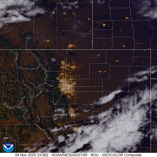
Greeley, Colorado
With the newly advertised atmospheric river coming for the Pacific Northwest, there stands to be a bit more interesting weather eventually trickling into the High Plains of Colorado. But how soon?
At 856PM, MT, Greeley was reporting clear skies and a temperature of 43 degrees. Greeley was a pit on the temperature map, as Fort Collins to the west and Fort Morgan to the east were both still in the 50s, while Greeley aligned more with Cheyenne and Laramie, where it had tarted to cool down. Flow is fairly calm, however there is a stream of high clouds showing up south of Denver.
The jet fostering low pressure will eventually emerge in the central Rockies, and dig into the high pressure in the Plains. Low pressure will begin to organize in Montana, drawing more warm, dry air through Greeley. With low pressure organizing so far north, there is no threat for rain in the Greeley area.
Tomorrow – Fair skies, High 67, Low 30
Thursday – Partly cloudy, High 70, Low 28
TWC: Tomorrow – A mainly sunny sky. High 66, Low 31
Thursday – A few passing clouds, otherwise generally sunny. High 68, Low 31
AW: Tomorrow – Mostly sunny and not as warm but pleasant High 66, Low 31
Thursday – Mostly sunny and windy High 69, Low 29
NWS: Tomorrow – Sunny, High 65, Low 32
Thursday – Mostly sunny, High 67, Low 34
WB: Tomorrow – Mostly sunny. High 65, Low 38
Thursday – Partly cloudy. High 65, Low 36
WN: Tomorrow – Mostly sunny, High 65, Low 35
Thursday – Partly cloudy, High 67, Low 36
CLI: Tomorrow – Sunny High 65, Low 31
Thursday – Partly cloudy High 68, Low 30
It’s such a wildcard this time of year in the High Plains and Front Range. The forecasts are all pretty similar, which means we are all going to be wrong in the same way. Satellite shows a few clouds tonight, generally to the south.
Rain that just won’t stop
I have a general rule of thumb in the winter. I won’t believe it is done snowing until it is actually done snowing. If there are flurries, I’m just going to keep those flurries in the forecast. There are thermodynamic reasons for this that maybe I can get into at another time. Those thermodynamic reasons don’t apply to light rain showers, but perhaps I should have heeded that “just leave it in the forecast” ethos when forecasting for Elkhart last month. Rain looked like it was on the way out of town when I produced the forecast, but it didn’t leave on Thursday the 23rd, as I assumed it would. It also didn’t leave on Friday, which more of us didn’t think was the future in Elkhart. This soggy end of the week was best handled by the National Weather Service, who collected a forecast win.
Actuals October 23rd: .07″ of rain, High 51, Low 37
October 24th, .02″ of rain, High 53, Low 34
Grade: C-D
Updates 11/3
3:57PM: Time for an advisory, if you need it: it’s November now, which means you need to start reviewing the WPC page for the heavy snowfall outlooks, as well as weaning off the SPC and NHC. Thank you, and apologies.
7:32PM: More from the WPC: All that incoming snow in the Pacific Northwest has been ascribed the atmospheric river label. It’s going to be snowy!
11:13PM: All this about the cooler weather inbound, I would be remis if I didn’t point out … It’s going to be warmer than normal for a healthy chunk of the country this week.
Updates 11/1
2:50PM: See how the clouds are kind of ribbed throughout New England? Well, that means it is quite windy across the region, at the level at which the clouds lie. I can tell you it is fairly breezy at the surface, as well.
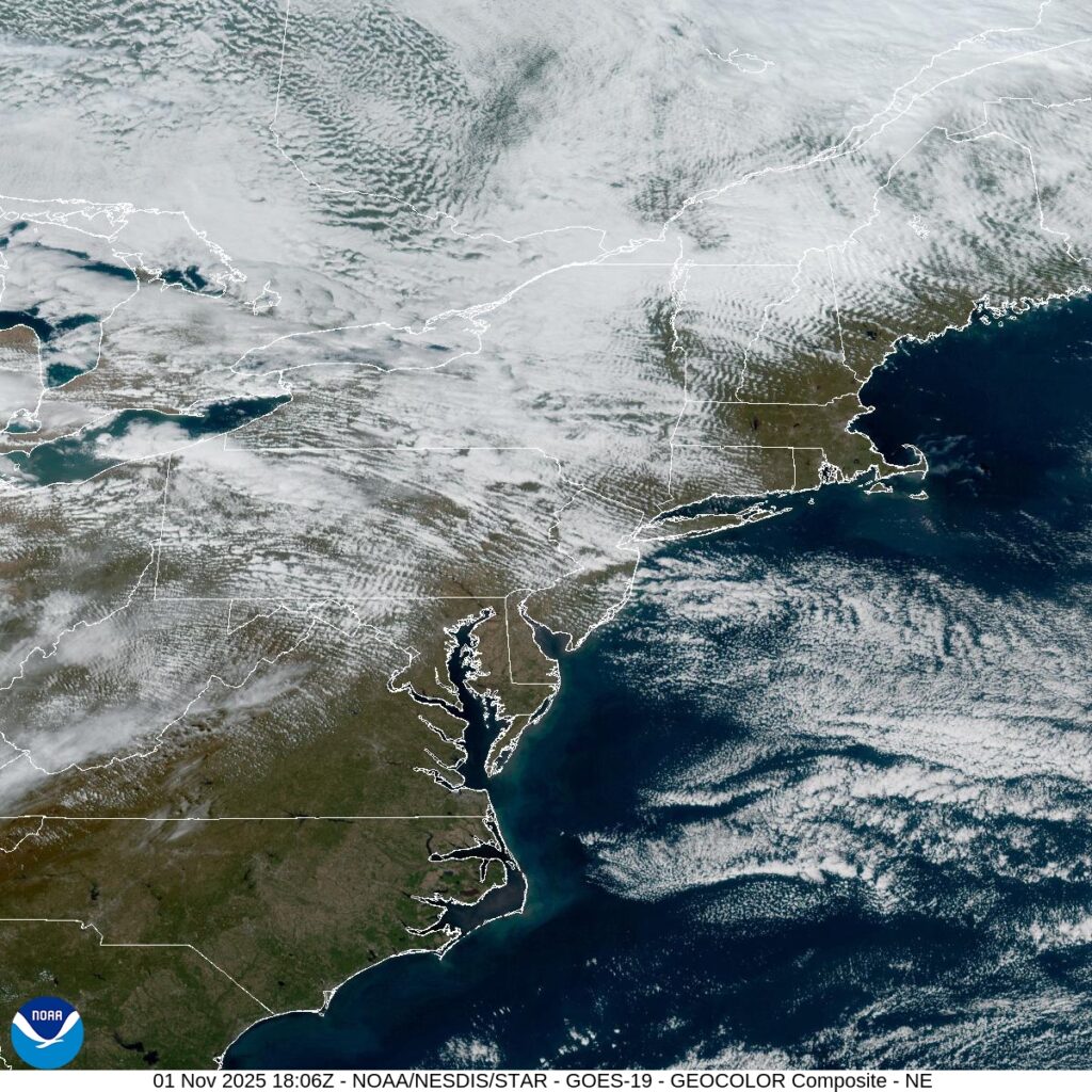
9:10PM: The wind that was evident in the image above is also responsible for bringing in quite a bit of chilly air. There are actually frost advisories tonight as far south as North Carolina.
Burlington, North Carolina
Burlington started its life called “Company Shops” because the railroads started the town as a spot to service trains in North Carolina. As railroads merged and the trains that used Company Shops put their work elsewhere, residents decided to rename the town. They picked the name “Burlington”…. naming the town after a passing train.
At 1059PM, ET, Burlington was reporting rain and low overcast. The temperature was 52 degrees. In the wake of a coastal feature that brought the region rain yesterday, another rain maker is moving out of the Tennessee Valley tonight. In this case, the area of low pressure is starting to move to the north, and an occluded cold front will be responsible for the rain overnight tonight.
Because of the occlusion, the post-frontal cooldown will not be dramatic. The rain will end through the late morning, with drier air and a bit of sunshine then filtering back into the picture. High pressure will build in, giving the region a much needed break from the rain.
Tomorrow – Rain early, then clearing, High 62, Low 48
Friday – Sunny, High 58, low 43
TWC: Tomorrow – Cloudy early, becoming mostly sunny in the afternoon (AM Rain) High 62, Low 49
Friday – Sunny skies. High 62, Low 43
AW: Tomorrow – Breezy in the morning; otherwise, clouds breaking for some sun (AM Rain) High 62, Low 49
Friday – Breezy in the morning; otherwise, plenty of sun; cool for trick-or-treating High 60, Low 41
NWS: Tomorrow – Cloudy, then gradually becoming mostly sunny, (AM rain) High 62, Low 49
Friday – Sunny, High 62, Low 42
WB: Tomorrow – Mostly cloudy. Showers likely in the morning. High 62, Low 49
Friday – Sunny. High 59, Low 45
WN: Tomorrow – Partly cloudy (early rain) High 62, Low 49
Friday – Sunny, High 62, Low 42
CLI: Tomorrow – Partly cloudy, High 62, low 48
Friday – Sunny, High 61, Low 42
Well, if the high tomorrow isn’t 62 degrees, I think I’m going to have to talk to someone. Pretty rainy tonight, but I did forget that Friday is Halloween, and that looks like a good night for Trick or Treating.
Updates 10/29
7:15PM: We are headed towards Halloween at the end of the week, and whether you like it or not, the weather looks to be on the warm side for a lot of the country. The core of the most above normal warmth looks to be around the Rockies, where Salt Lake City is looking at temperatures around 60 degrees. Trick or Treat!