I verified Raleigh earlier this week, and completely skipped over the verification for Providence. This was a busy forecast, with some rain coming into the area just as Thanksgiving was drawing near. There was rain on both Wednesday and a bit of a splash on Thanksgiving Day. As promised, the weather cleared by afternoon, which allowed locals to get out of the house and go for a walk to allow all that turkey to digest. The rainfall wasn’t universally included in the forecast, which really shuffled the standings. Weatherbug had the top temperature forecast, but fell back into a tie with Victoria-Weather – which makes me even more irritated I missed the verification! -for first place. Actuals: November 26th, .18″ of rain, High 59, Low 53 Thanksgiving – .01″ of rain, High 55, Low 37
Tonight’s forecast will take us to New England through the Thanksgiving holiday. How will Rhode Islanders enjoy the day?
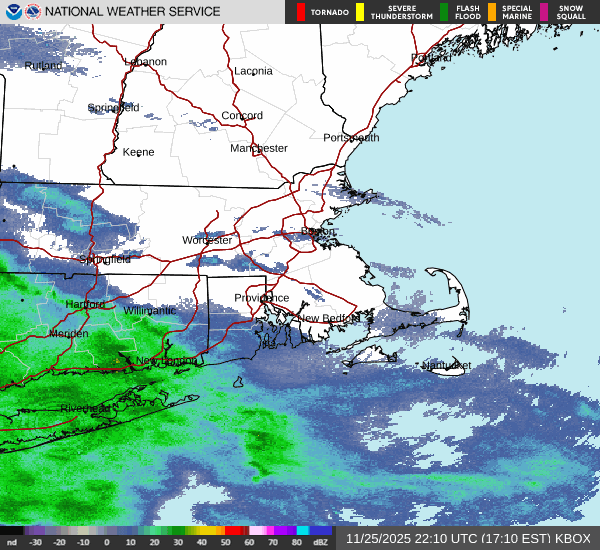
At 451PM, ET, Providence was reporting a temperature of 50 degrees with overcast skies. Rain was approaching, already sneaking into the southwestern corner of Rhode Island, at the leading edge of a warm front. The system is deeply occluded, and the cold front will pass through overnight as well. Southerly flow will follow the secondary cold front on Wednesday, which may drag a bit of moisture into the region, leading to a cloudy, at times drizzly day before Thanksgiving. There is one last wave of moisture expected to slide through New England on Thanksgiving, but it is unlikely that there will be lingering effects. The day will be increasingly sunny, and quite pleasant by dinner time. Happy Thanksgiving! Tomorrow – Rain, particularly early, with lingering showers throughout, High 59, Low 48 Thanksgiving – Some drizzle early then clearing and colder, High 55, Low 33
TWC: Tomorrow – Chance of a morning shower. Overcast. High 59, Low 48 Thanksgiving – Sunny along with a few clouds. High 55, Low 36
AW: Tomorrow – Rather cloudy with a couple of showers; wet weather can make for slow holiday travel High 61, Low 48 Thanksgiving – Sunny to partly cloudy, windy and cooler High 55, Low 34
NWS: Tomorrow – A slight chance of rain between 9am and 3pm. Patchy fog. High 61, Low 47 Thanksgiving – Mostly sunny, (AM Rain) High 56, Low 36
WB: Tomorrow – Cloudy with a 20 percent chance of rain. Patchy fog High 59, Lo 50 Thanksgiving – Sunny High 55, Low 36
WN: Tomorrow – Mostly cloudy with isolated showers, High 61, Low 47 Thanksgiving – Mostly sunny (early showers), High 54, Low 35
CLI: Tomorrow – Overcast High 60, Low 50 Thanksgiving – Partly cloudy, High 56, Low 35
Rain will be light, regardless of what happens, for a lot of the forecast period. And temperatures will be on their way down, so the Turkey Day Touch Football game looks to be a good way to warm up. Radar showing rain moving in is below, and if you are looking to get really involved, here is a live camera from Providence.
We are free of hurricanes for a couple of days, at least, so we can take a guilt free trip from Illinois to New England. The drive will cover 1,152 miles over the course of two days. The pace of the drive will be about 66.5mph, which is pretty good, considering it terminates in New England. The faster of the two days will conclude after 532 miles. Hurricane season is also foliage season, so New England is a perfectly reasonable place to visit.
DAY ONE (Sunday)
Springfield, Illinois
High pressure is parked over the southeastern part of the country. It was crucial to keeping Milton from moving any further north, and instead cutting across Florida and jetting into the Atlantic. The storm was very bad where it struck, but it missed out on a lot of geography, which is good news. Now after the ridge has performed it’s life saving duty, the northern fringe is pressing south, thanks to a strong wave skirting the Great Lakes. There is quite a bit of wet weather in Lower Michigan, ready to drift into northern Ohio. As we travel out of Illinois through central Indiana Sunday, it will be dry, but increasingly cloudy in Ohio. I think the rain will b in Pennsylvania be the time we get to the eastern part of the Buckeye state, but thre could be a small bit of damp in Palmyra (southeast of Cleveland near the Pennsylvania border), where our day will come to a close.
DAY TWO (Monday) A surprising amount of cold air will trail the cold front with the system moving into the Great Lakes. It will be chilly when we start in Palmyra, and there will be a few spots of showers peaking around the western exposures of the Poconos. Further north, higher terrain in New England will likely see their first snowflakes of the year. As the sun comes up, and the cold air settles in and snuffs out any instability, we will get into clearer air. The drive through Connecticut will be thick with traffic, I am sure, but it will dry and chilly until we reach Providence.
We are going to head right into the heat here in the dog days of summer. There will be a point where we have to pass through some storms to get from moderately more tranquil weather in New England to the steamy south, but where will it happen along our 2013 mile journey? And when, over the 4 day trek? As you might be able to establish, we will cover a bit more than 500 miles a day (519, actually) while traveling at a pace just shy of 65mph, which is somewhat slow, thanks to the tangled web of the east coast, and not a fear of impending thunderstorms.
Providence, Rhode Island
DAY ONE (Tuesday) Naturally, the feature first expected to impact our journey will be a weak shortwave trough moving out of the Great Lakes. Why is this great? Because I’m being sarcastic, and this will be difficult to forecast around. There is consensus that we will be dry through the New York City area, but then it becomes a little dodgier. I think the model that brings a lot of rain to Pennsylvania is doing so because of poor resolution. I think it’s going to generally be mostly cloudy with some isolated spots of rain, but maybe not enough to even turn the wipers on. These dots will be possible for the rest of the journey, though becoming less likely as we pass into Virginia. The day will end in New Market, Virginia, in the northern part of the state.
DAY TWO (Wednesday) Another wave moving into the Great Lakes is going to carry with it a bit more weight. Inflow towards the low might lead to some fog and haze in the Appalachians and Smokey Mountains, but the potential for heavy thunderstorms will arise in Tennessee. Not widespread, destructive thunderstorms, mind you, but isolated, pop up showers and storms of questionable coverage. The strongest storms will stay west of the Appalachians, and coverage will begin to wane as a strong batch of storms erupts over northern Missouri late in the afternoon. We’ll make it to Reece City, Alabama, northeast of Gadsden.
DAY THREE (Thursday) I’m not in the market for going out on an island to predict tropical storms, but I will say, there looks like a week area of low pressure developing over the western Gulf through the middle of the week. Alabama will stay dry on Thursday morning, but some scattered showers will pop up fairly early in Mississippi, and we should be soaked through southern Louisiana. Thunderstorms are likely, but I would be surprised if any of this activity is severe. We’ll stop just west of Lafayette, in Scott, Louisiana.
DAY FOUR (Friday) That at times steady rain, with a few embedded thunderstorms, will continue through western Louisiana, and may even remain a concern as deep into Texas as Houston, but after we reach the western suburbs, I think we are in the clear. Just in time for more oppressive heat! At least there will be a few clouds every here and there, but not enough to make things feel significantly diffeent in San Antonio than they did in Providence.