8:15PM: The week ahead is going to provide more threats for severe weather, but not nearly as vivid as it was in the past few weeks. On the north end, there won’t be the snow inducing cold air. Instead, just enough to induce this cute graphics pack from NWS Aberdeen.
11:15AM: With spring running a bit cool right now, and so many stories about rain afflicting the mid-South and Appalachia, we would be forgiven to not realize how dry the northern High Plains have been. There are red flag warnings today from northeastern Colorado through the Dakotas. Compounding matters is the surface pattern, which is allowing for winds gusting 35-45 miles an hour. If fire does crop up, they will whip up and spread quickly across the prairies.
11:25PM Weatherbug had the best month forecasting last month, and while yes, the actual forecasting was good, I have to believe that a huge part of it is that they got rid of side scrolling for hourly forecasts.
9:32PM It’s a quiet night across the country. The bulk of he warnings on the national map are temperature related, which is not what one expects to see on April 8th.
11:20PM Another sign that the seasons are changing. A fairly organized complex of fronts is going to move out of the Plains and into the Great Lakes through the next 48 hours. Why is this unusual? Because it’s not really going to DO anything. How can we tell it will move through? It will be partly cloudy and 75 or so tomorrow in Omaha (after lower 60s today). On Wednesday and Thursday, it will be partly cloudy and 65.
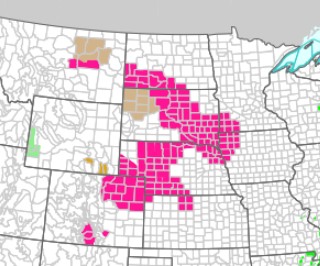
1153PM Where did those thunderstorms end up bringing severe weather to? As you may recall, we were looking at an enormous area of severe weather risk leading into the day.
A little towards the northern end of the risk area. For fun, here is the map for today.
3:19PM – Low pressure in Eastern Canada is quit occluded, enough so the original low has kicked off a secondary trough breezing through the western Great Lakes. There is a little rain in Minnesota and Iowa, and some strong gusts as well.
7:02PM – The system moving through the country this weekend is evocative of an Alberta Clipper. It starts today in the northern Rockies and will get stronger as it dives southeast, where the best shot for severe storms will crop up on Sunday. And yes, there will probably be some snow, up on the Canadian border and Northern Great Lakes.
8:00PM It’s been storms across a big cross section of the country that have earned a lot of headlines, but one area that hasn’t seen the rain is Florida, and to a degree, the Coastal Plains. Moderately dry conditions are leading to concerns for fires in this area. High winds further west also bring worry about fire and how fast they would spread in the Plains.
1051AM We had a long lead to some severe weather last week, and we are in a similar scenario this week, but unlike last week, the threat is growing ominous the closer we get to the event. Friday and Saturday will offer some strong thunderstorms, starting in the Mississippi Valley on Friday, where there is already a 30% chance of severe weather, which suggests an enhanced or moderate risk is coming in future updates. Pay attention to this one.
130PM I should have noted in the earlier update that the outbreak looks to be multiple days. Saturday has a 30% bullseye over Alabama
2:37PM Only one severe storm ongoing right now, headed for Freeport, Florida. You’ll see it coming…. There is a LOT of lightning
827PM Storms are ongoing in the southeastern United States, but nothing is severe right now. There might not be anything severe until late this week, when storms in the Mississippi Valley could be widespread.
1055PM To tell you how far from significant weather we are tonight, I’ve encountered quite a bit of conversation on the storm at the end of the week. The storms in the Mississippi Valley, yes, but a wintry mix in the northern Plains will be difficult Friday to Saturday. But we’ve got time.
1125pm – The threat for stronger storms has again increased late in the day. A marginal risk was plopped in Texas as a narrow band of thunder cropped up in the middle of the state, drifting north.
There are snow showers and winter weather alerts from Oklahoma to New Mexico, stemming from this very system.