I’m looking a little bit at the Harrisonburg forecast…

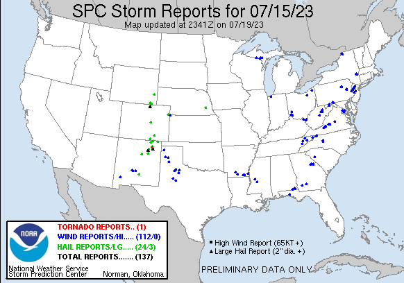
I’m looking a little bit at the Harrisonburg forecast from a few days ago, and I am reminded that, because of the combination of high population and density of vegetation, the region is very sensitive to wind storms. While in the Plains or Midwest, you see long track lines of severe weather with the heaviest storms, you get mottled spasms of wind reports out east like they did over the weekend in the Atlantic Coastal Plains.

The Pueblo office as a map of high temperatures

The Pueblo office as a map of high temperatures that not only gives some good weather information, but also demonstrates Colorado’s topography pretty well. Of course, there is the lower temperature readings found in the mountains in the western 3/5ths of the state, but also, the break between 100s and lower temperatures is close to the Palmer Divide, which usually makes Denver a totally different weather scene than Pueblo or Colorado Springs.

Well, the heavy rain has moved on from Harrisonburg…

There was certainly some rain in the forecast with the next round of wet weather coming through, but there was a question of timing, and it always makes me wonder what the radar signatures will look like when it comes to pass. Well, the heavy rain has moved on from Harrisonburg, which is good news for those hoping for a dry Sunday. The rain has been quite steady too, especially in the lower terrain south of Harrisonburg through the center of the state.

Smoke before the heat

A system working it’s way through the country is temporarily bringing some more comfortable weather across the middle of the country. Of course, there is more smoke behind this system, and there is a lot of red skied sunsets across the northern Plains tonight. And of course, it’s going to roast again. Check out the next several day forecast out of Wichita.

Today has been a scary severe weather day

Today has been a scary severe weather day, with the tornadoes in Chicago. There is ongoing severe weather in Lower Michigan and in the middle of the country from Missouri to Kansas. The severe weather will return tomorrow, coupled with more flash flooding possible in New England, Vermont in particular. Severe weather is coming from the Eastern Great Lakes, through the Ohio Valley, as well as in the high Plains – tornado alley. Friday is going to be quieter, and right now, at least, it looks even better for the weekend.

The tail end of a tornado outbreak is wrapping up in Chicago.

The tail end of a tornado outbreak is wrapping up in Chicago. Unfortunately, the densest population in Chicago is on the Lake, so the worst may still be to come. Look at the radar progression this evening, as those tornado reports crop up through the evening.

There have been reports of damage that started in Huntley with roofs and tree damage, then more to the south around La Grange, with the final set of reports coming from Bloomingdale to O’Hare Airport. Having a tornado outbreak in a metropolitan area as densely populated as Chicago is a scary scenario, and we will await news from the authorities, as storms roll out into the Lake.