Weirton lies along the banks of the Ohio River, while St. Joseph is on the Missouri. Maybe they aren’t the most famous towns on their respective rivers, but they do offer a chance to get up close to them. It will require a day and a half drive over the course of 832 miles. Our first day will conclude 518.7 miles in, slowed by travelling off-interstate to a pace of 64.8mph.
DAY ONE (Tuesday)
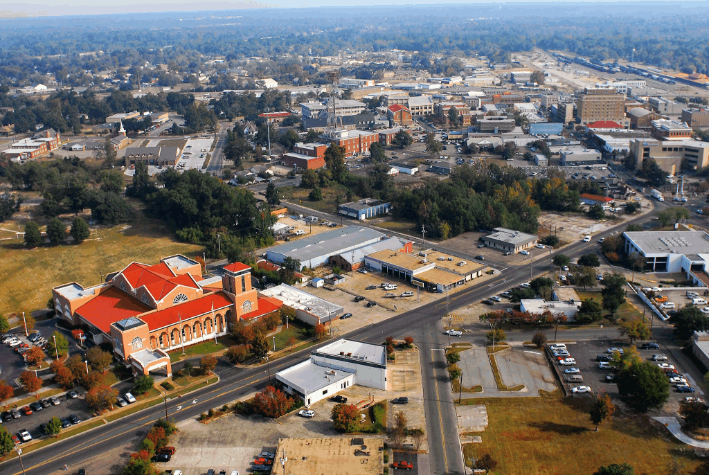
Weirton, West Virginia
High pressure has nosed into the western Great Lakes, and will suppress much rising air, which usually just means that there won’t be any showers or storms in the area. This is true, but for our purposes, it means an inversion across much of the region as well. This suggests there will be A) low clouds and B) morning fog, thanks to the high moisture content in the region, thanks to snow melt and a lack of motivation to clear out. As the day goes on, expect improved visibility and maybe even a bit of sun in the afternoon over Illinois and Indiana. We’ll stop in Buffalo, Illinois, between Springfield and Decatur, for our sole break of the trip.
DAY TWO (Wednesday) A weak feature sliding along the Texas Gulf Coast will extend an inverted trough to the Show Me State, which means a few wet flakes across the region. Given the temperatures, it seems likely that this will lead to some especially icy roads in northern Missouri, even if there isn’t a lot of accumulation. I’m concerned about the threat for some freezing mist in the morning. Drive safely!
That, my friends, is a lot of W’s. We are going to trek through the Great Lakes right in the middle of winter. Does this mean Lake effect snow? Maybe! There is only one way o find out, I suppose. Our drive till take one long day, covering 606 miles, bogged down by the Windy City, which will let us move at a nearly glacial pace of 62mph. We’ll get there. Sometime.
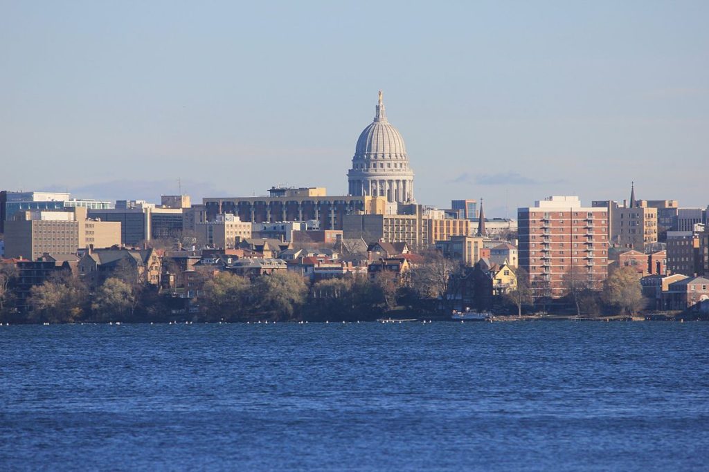
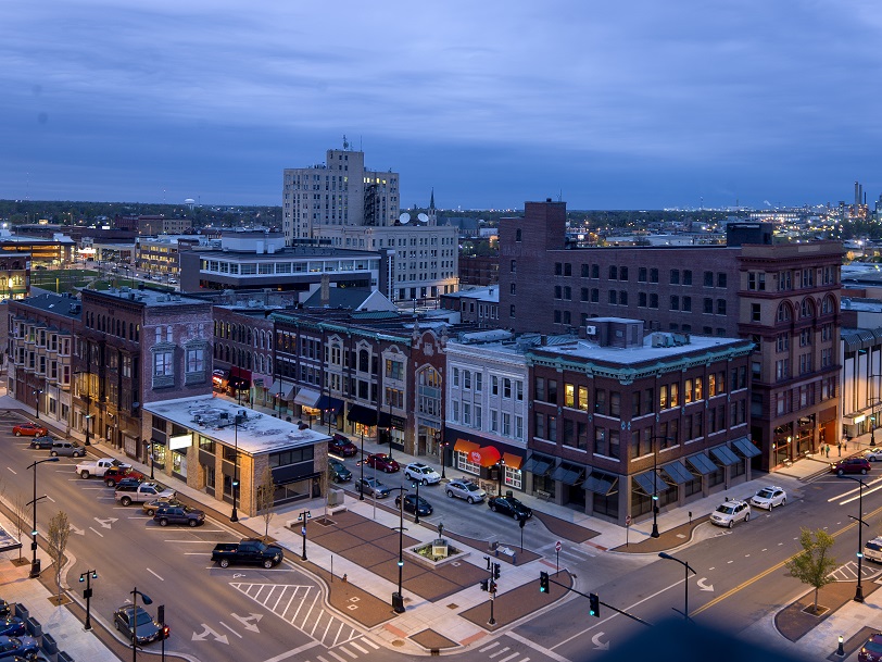
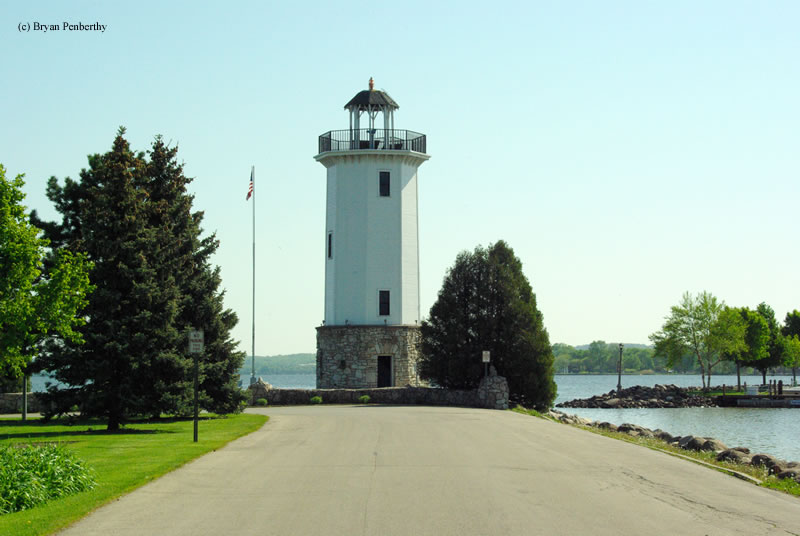
Madison, Wisconsin
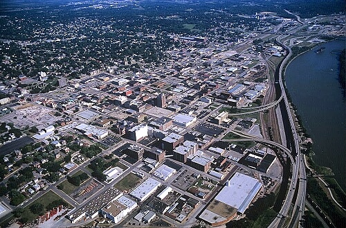
It’s not Lake effect snow that will be the problem on our Saturday drive, but rather just standard, regular back side of an area of low pressure snow that will be an issue. It’s not going to be heavy, save, perhaps for the stretch of northern Indiana downwind of Lake Michigan. the snow will be wet, too, and well trafficked roads might not even ice over with the snow. But any snow, especially in a metropolitan area like Chicago, is going to really slow down travel. Snow will still be possible across Ohio, but it will be a misty, flaky brand of snow that won’t accumulate and will be tough to wipe off your windshield without the help of washer fluid. Weirton awaits, whether or not you can get the grime off your windshield.
I think this might be the first road trip of the year, right? It will be a 3 day trip through the heart of the country, covering 1689 miles at a pace of about 65mph. That will mean the first two days will be complete after just short of 520 miles on days 1 and 2, with a 10 hour day coming on Sunday. 2020, here we come!
DAY ONE (Friday)
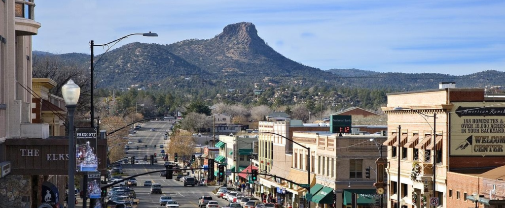
Prescott, Arizona
We are headed for a trip through the southern Rockies at the right time. Atmospheric instability is confined to the central Plains for the most part, with a dose in the northern Rockies, leaving Arizona and New Mexico fairly unperturbed. We’ll check in on Flagstaff and Albuquerque on our eastward journey, stopping west of Santa Rosa, New Mexico to end our day and our work week.
DAY TWO (Saturday) As we continue to the east, we’ll slice through a couple of Panhandles before spending the rest of the day in southern Kansas. I don’t recall ever spending much time in this part of the world on a road trip, and I especially don’t remember cutting through Wichita to get anywhere. Usually, it’s just a bypass on I-35. Not this time! Instead, we will enjoy an increasingly warm day, free of any atmospheric interference before we reach El Dorado, where we will end our day. Along the way, appreciate Greensburg, a city that has had to completely rebuild after a devastating tornado in 2007.
DAY THREE (Sunday) Sure, this day will be the longest, and it will also be the gloomiest, with clouds becoming much more likely thanks to a combination of general troughiness* over the Plains, and the melting snow north of Kansas City leading to clouds and fog along most of the route. On the other hand, at least the car won’t be unbearably hot because of the penetrative sun, and we will get to see Des Moines! And Dubuque! Both are very nice towns. So is Madison, for those unaware.
It seems like these two towns should be nearer to one another, but in fact, it’s a day and a half drive between Miami, way at the south end of Florida, and Hattiesburg. To give you an idea of how big Florida is, our drive covers 817 miles in total, and probably 3/4ths of it are in the Sunshine State. We will do 2/3rds of the driving on day one, which will account for 542 miles at the Floridian pace of 67.8mph, It’s a long ways from Miami to any other state, so be patient.
DAY ONE (Saturday)
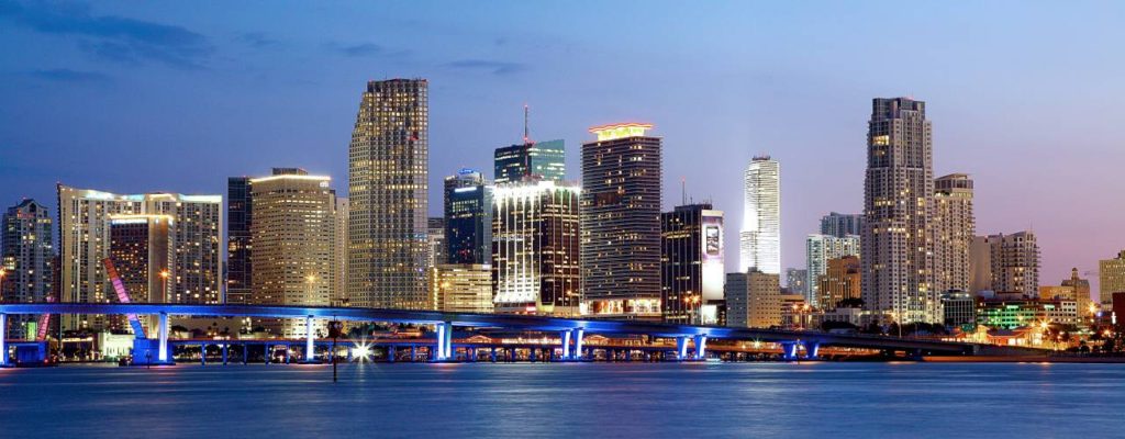
Miami, Florida
A long, dangling front extends from a low over Newfoundland. If that gives you any idea, by the time the front has reached north Florida, it is quite weak, and as we drive north, it may only bring a few clouds over Orlando. North and west from the Ocala and Gainesville area, however, we will probably note a change in the air. Somewhat cooler air is possible, but more significantly, it will feel drier than Miami. We’ll make it to Grand Ridge in the Panhandle to call our day complete.
DAY TWO (Sunday) High pressure is developing over the East Coast this weekend, and guidance is suggesting that the return flow will be strongest in the Mobile area. There might be some light rain showers as a result, but more likely, it will just be some puffy cumulus clouds. Hattiesburg won’t have to deal with any of that, but the afternoon will be getting warmer and soupier after we arrive.
On this Saturday evening, all I can think is that this drive is going to take us right through SEC country. We’ll depart from ACC territory, I suppose, as we take an 8 hour, somewhat circuitous drive to northern Alabama. We will be on the road covering 507 miles at a pace of only 64.9mph. But really, check out this route.
Charlotte, North Carolina
There is a small, tightly wound area of low pressure shuttling through the southeastern US towards the Mid-Atlantic overnight tonight. By the time we wake up to get on the road, the low will be a thing of the past, leaving only a shallow lee trough, which may aid in the development of some fog in the wee hours. After we get to the higher terrain in South Carolina, and then head through north Georgia in the daylight, we will only be concerned with traffic and the sun shining in our eyes. All in all, Saturday will be the better day to travel this weekend.
A trip through the Rockies and Plains as a vigorous system moves through the region… I see no reason to worry! Our three day trip will feature an extended third day, and 1,861 total miles covered. We’ll navigate the terrain of the Rockies in our shorter two days, which will conclude after 551miles of travel, all at an average pace of about 69mph. Nice.
DAY ONE (Thursday)
Reno, Nevada
There is a string of features extending from the northern Praries of Canada to the High Plains to the southwestern US. Epic rains are falling around Phoenix and in the southern Rockies, with snow falling at the highest peaks. By the time we get going tomorrow, the system will have weakened, with precipitation becoming limited to the upper elevations along our route. We may not see any precipitation on the roads, but there will be some nearby, in the Ruby Range in northeast Nevada, and by Park City, Utah. We’ll stop in Coalville, not too far beyond Park City.
DAY TWO (Friday) As high pressure filters back into the High Plains, moisture will be scoured out of the low lying terrain. We might see some mid level or high clouds as we trek through Wyoming, north of the snow falling in the peaks of Colorado. Wyoming has a lot of beautiful parts, but none of them are along I-80, so hustle through and get to the western part of Nebraska, where we will stop in Brule for the night.
DAY THREE (Saturday) The very same system that we saw on Thursday will be sweeping through the Lower Mississippi Valley, shuttling to the northeast. An inverted trough at the north end of the low will be pointed into Illinois, into some chilly air. Nebraska and Iowa should be sunny and dry, but the threat and intensity of snow will increase the closer we get to Decatur.
Hello, and happy weekend! If you are ready for this southeastern US trek, then I am too. It’s an 837 mile trek, and if we did it in 1 day, it would take 12 hours. Possible, sure, but I think we would all prefer a more relaxed day and a half pace. We’ll cover the ground at a clip of nearly 70mph, which is a great advertisement for I-75.Our full day of travel will conclude after about 558 miles.
DAY ONE (Monday)
Bowling Green, Kentucky
We are picking a great day to depart from Bowling Green. Another reinforcing bolt of Atctic air is pressing into the center of the country, which will bring more wind and rain to Kentucky and Tennessee by the time Monday is thorugh. Fortunately, it will get to the route between Bowling Green and Chattanooga well after we have reached Georgia. The Peach State will still be it’s regular sultry self, with a bit of added humidity ahead of the strong emerging cold front in the Ohio Valley. We’ll be in the safety of Florida by the time the day ends, spending the night in Jasper, not far across the state line. Good thing bad weahter never comes to Florida.
DAY TWO (Tuesday) That strong cold front will continue to sink to the southeast, it will lose most of it’s on shore mustard. Sure, there will be wind and some mid level clouds, but most of the actual rain showers will lie offshore. We should outpace the cold front, but a head wind will be gusting towards the lower pressure, so be sure to grip the steering wheel securely. Always good advice when driving in Florida, actually.
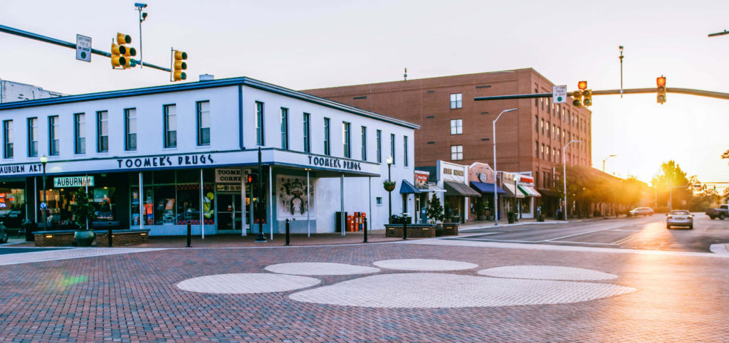
Today’s journey takes us along I-65, one of my old favorite arteries, running from Chicago to Montgomery, but we will end up both north and south of that highway by the time all is said and done. It’s a 2 day trek covering 931 miles. The first day will be longer, concluding after about 502 miles. We’re going to see some weather, so hopefully we make good time outside of the storms.
DAY ONE (Thursday)
Auburn, Alabama
The weather is going to be nice in Alabama tomorrow morning, as warm Gulf air is drawn northward, taking the edge off of the autumn by just a little bit. Nice! Of course, the reason it is going to move to the north is a massive, nasty cold front at the leading edge of a strong ridge of high pressure sinking into the Great Lakes. The resulting boundary will be in our path, starting with a few rogue showers and thunderstorms north of Birmingham, with heavy rain and wind, perhaps even severe, in Tennessee and southern Kentucky. The trailing air mass is going to be cold an dense, so the cut off from rain to clear air will be abrupt. Expect a change in wardrobe if we need to stop anywhere north of Bowling Green, Kentucky, The night will be clear when we call it a night in Scottsburg, Indiana, north of Louisville.
DAY TWO (Friday) While the rain we see on Thursday is going to be a pain in the butt, it will come with a good navigational consequences, Sure, Indiana, Illinois and Wisconsin will be awfully chilly, they will also be sunny and dry. With a fresh bit of snow in Wisconsin, keep those sunglasses at the ready.
All right, friends, it’s about time we engaged in a cross country, 5 1/2 day monster of a road trip. we will cover a whopping 2,914 miles to get from the East Coast to central California. A lot of time on interstates will mean a brisk 66.2mph pace and 529.8 miles covered a day on those full days in the car. We might see snow, and we might see fires Sounds pretty dynamic, doesn’t it?
DAY ONE (Tuesday)
Salisbury, Maryland
Things will be off to a good start on Tuesday, with warm high pressure settling into he Appalachians and throughout the DC/Baltimore region. We shouldn’t have any issues, even with tolls, as we will be traveling the southern route through Ohio, the one that avoids the toll road, but not Columbus. We’ll stay in Lake Darby, a western suburb of the Ohio State Capital.
DAY TWO (Wednesday) I have some good news for Wednesday! It probably won’t snow! A warm front will reach north towards the southern Great Lakes overnight, and we will be in rain almost from the time we get moving. There is a chance at some thunderstorms over southern Indiana and Illinois, but by the time we reach Missouri, the cooler air will be moving in. The thunder threat will long be over, and instead a chilly rain will overtake the thunder. Maybe after we stop for the night in Devil’s Elbow in central Missouri, a wet snowflake could mix in.
DAY THREE (Thursday) Undoubtedly, our coldest day will be Thursday, Halloween. How cool is it that we will start Halloween in Devil’s Elbow? We’re going to contend with the remnants of a few snow showers for the first couple hours of the day, concluding before we reach Springfield, and then Oklahoma will simply offer a chilly wind as we nagigate the Sooner State. We will only just start to enter Texas when we call it a day in Shamrock, where west winds suggest we will finally be reaching a bit warmer air.
DAY FOUR (Friday) November will get off to a pleasant start. Nary a cloud in the sky as we head through the Texas Panhandle and New Mexico, and temperatures should start warming a bit too. We’ll stop for the night in Manuelito, New Mexico, on the Arizona border.
DAY FIVE ( Saturday) Another day on the road out west, and another day with little to worry about. We’ll navigate Arizona without a concern, and reach southern California where it will be much warmer than we are used to. The day will end near Barstow, but far away from the fire concerns near the coast.
DAY SIX (Sunday) I suspect that by next weekend, the fire danger in California will be significantly dampened. That will make for a less hazy drive through southern California. Madera looks to be in fine shape for our arrival.
Madera, California By Jcarrello – Own work, CC BY-SA 4.0, https://commons.wikimedia.org/w/index.php?curid=52965015
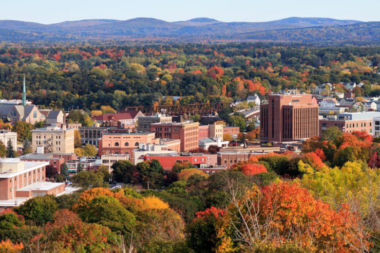
Let’s go for a drive. And while we’re at it, let’s go for a drive in the fall before the Lake Effect machine gets going. It takes two days to get from northern Indiana to Maine, though the second day might be an hour longer. The distance is 1,151 miles, which we will navigate at a speed of 65.5mph, pinning us somewhere in New York to conclude day one, with the left to spare on day two.
DAY ONE (Tuesday)
By Cameronloyd03 – Own work, CC BY-SA 4.0, https://commons.wikimedia.org/w/index.php?curid=61605902
Fall is coming to the northern part of the country, and it s coming in the form of a cold front sweeping into New England as we speak. Cool high pressure is pressing into the Great Lakes, and as we leave Kokomo, we will be headed right into this high pressure. We’ll make our way through northern Ohio and drive the southern shore of Lake Erie, all with barely a cloud, and make it to Le Roy, New York, south of Rochester as we take our sole pause on the journey.
DAY TWO (Wednesday) As that cold front gets off shore, it will phase with an upper level trough, and start development into an early season nor’easter. Terrific! Most of the drive in the Empire State will be dry, but east of Albany, the rain will start. It will be persistent and accompanied by stiff gales all the way through Massachusetts. Leaves are still on trees, so watch out for branches and debris on the roads, but as we pass through Haverhill and into New Hampshire, we will be in the clear, back into that cool, perhaps cloudy high pressure, into Bangor.