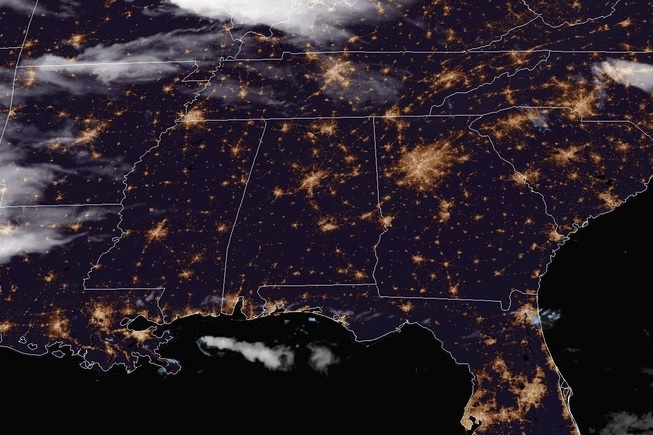
Tonight let’s take a trip down south and see how the rest of the weekend shapes up for the lovely folks in Montgomery, AL!
At 953pm CDT, the temperature in Montgomery, AL was 74 degrees under fair skies. The tail end of a boundary is working through the TN Valley this evening, but behind it high pressure is moving in. This area of high pressure is going to keep the Montgomery area dry over the next couple of days, with just a few passing afternoon clouds anticipated. Looks like a good start to the month!
Sunday: Sunny. High 93, Low 66.
Monday: Few afternoon clouds. High 92, Low 68.
TWC: Sunday: Mostly sunny. High 94, Low 65.
Monday: Partly cloudy. High 93, Low 68.
AW: Sunday: Mostly sunny; warm. High 90, Low 64.
Monday: Mostly sunny; warm. High 89, Low 68.
NWS: Sunday: Sunny. High 93, Low 68.
Monday: Sunny. High 91, Low 70.
WB: Sunday: Sunny. High 92, Low 66.
Monday: Mostly sunny. High 91, Low 69.
WN: Sunday: Mostly sunny. High 93, Low 68.
Monday: Mostly sunny. High 91, Low 70.
FIO: Sunday: Clear throughout the day. High 93, Low 66.
Monday: Partly cloudy until evening. High 92, Low 70.
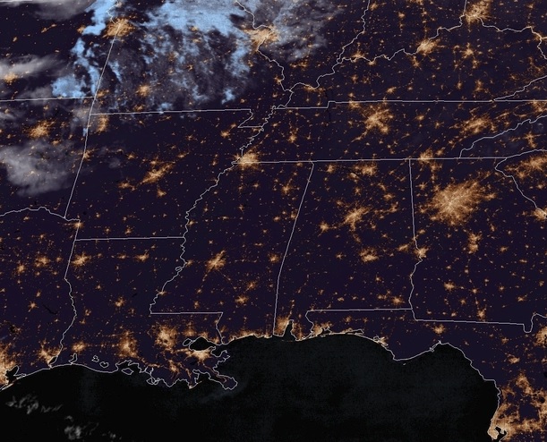
Here we see a fairly calm and clear night over the Deep South, with much of the same expected over the next couple of days.
Happy Mother’s Day to all the Moms up on Sunday night reading weather blogs!
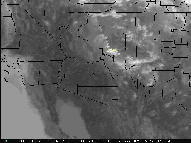
At 551PM, PT, Phoenix was reporting a temperature of 80 degrees with overcast skies. The overcast was a high overcast, and not indicative of any significant weather in the area. There was a it of instability in the southwestern United States in conjunction with an upper level wave, but the shower activity has steered clear from Phoenix. The tail of the jet providing the upper level instability for these showers and storms will pull west through Texas as the week begins. This will leave a weak upper level ridge in the desert Southwest, and Phoenix is in the clear to start the work week. Tomorrow – Increasingly sunny, High 91, Low 68 Tuesday – Sunny, High 95, Low 75
TWC: Tomorrow – A mainly sunny sky. High 94, Low 66 Tuesday – Partly cloudy skies. High 98, Low 70
AW: Tomorrow – Partly cloudy skies. High 92, Low 66 Tuesday – Mostly sunny; warm High 97, Low 71
NWS: Tomorrow – Sunny, High 94 Low 65 Tuesday – Sunny, High 97, Low 69
WB: Tomorrow – Sunny and warmer, High 92, Low 65 Tuesday – Sunny in the morning then becoming partly sunny, High 96, Low 71
WN: Tomorrow – Sunny, High 94, Low 65 Tuesday – Mostly Sunny, High 97, Low 69
FIO: Tomorrow – Clear throughout the day. High 95, Low 65 Tuesday – Clear throughout the day. High 98, Low 68
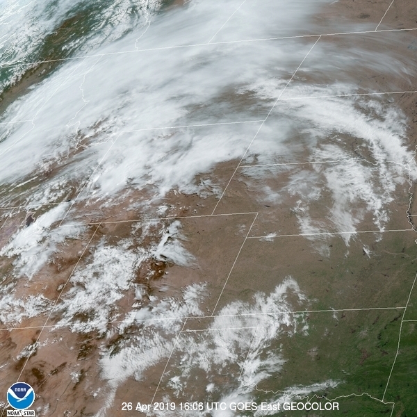
Looks like we are on the cool end. Hard to think warm thoughts when you are living a cool spring. Here is the satellite with a rogue thunderstorm closer to Yuma.
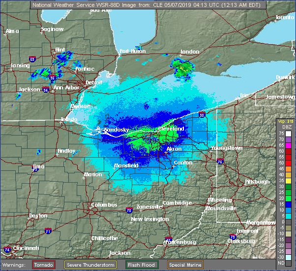
As we start off the workweek, let’s travel to the shores of Lake Erie and see what Sandusky is up to!
At 1153pm EDT, the temperature at Sandusky, OH was 60 degrees under fair skies. There’s a very slow moving frontal boundary over southern Michigan and looks to sag slightly south over northern Ohio tomorrow, giving the Sandusky area a chance of shower activity. It will remain overcast throughout the day and well into Wednesday as well, despite the boundary lifting back north a bit. An area of low pressure will be intensifying during the day Wednesday as it approaches the region, but the best chance of showers with this system will be early Wednesday as the front lifts well north during the afternoon/evening and it won’t be until early Thursday morning until more significant showers/storms enter the area. Until then, it will be a murky and cool couple of days.
Tuesday: Isolated midday showers. High 59, Low 46.
Wednesday: Mostly cloudy, scattered showers. High 57, Low 45.
TWC: Tuesday: Cloudy, isolated showers. High 56, Low 47.
Wednesday: Morning showers, windy. High 52, Low 46.
AW: Tuesday: Occasional rain and drizzle. High 57, Low 48.
Wednesday: A shower and thunderstorm around. High 52, Low 45.
NWS: Tuesday: Slight chance of showers/storms. High 58, Low 48.
Wednesday: Chance of showers then storms. High 54, Low 45.
WB: Tuesday: Mostly cloudy, chance of showers. High 58, Low 45.
Wednesday: Chance of storms. High 51, Low 45.
WN: Tuesday: Mostly cloudy with isolated showers. High 56, Low 45.
Wednesday: Mostly cloudy with scattered showers. High 54, Low 45.
FIO: Tuesday: Foggy overnight. High 60, Low 49.
Wednesday: Mostly cloudy thru day, breezy in afternoon. High 55, Low 46.
There’s a few light showers off to the northwest in Michigan, we’ll see these spotty showers a bit closer to home over the next couple of days.
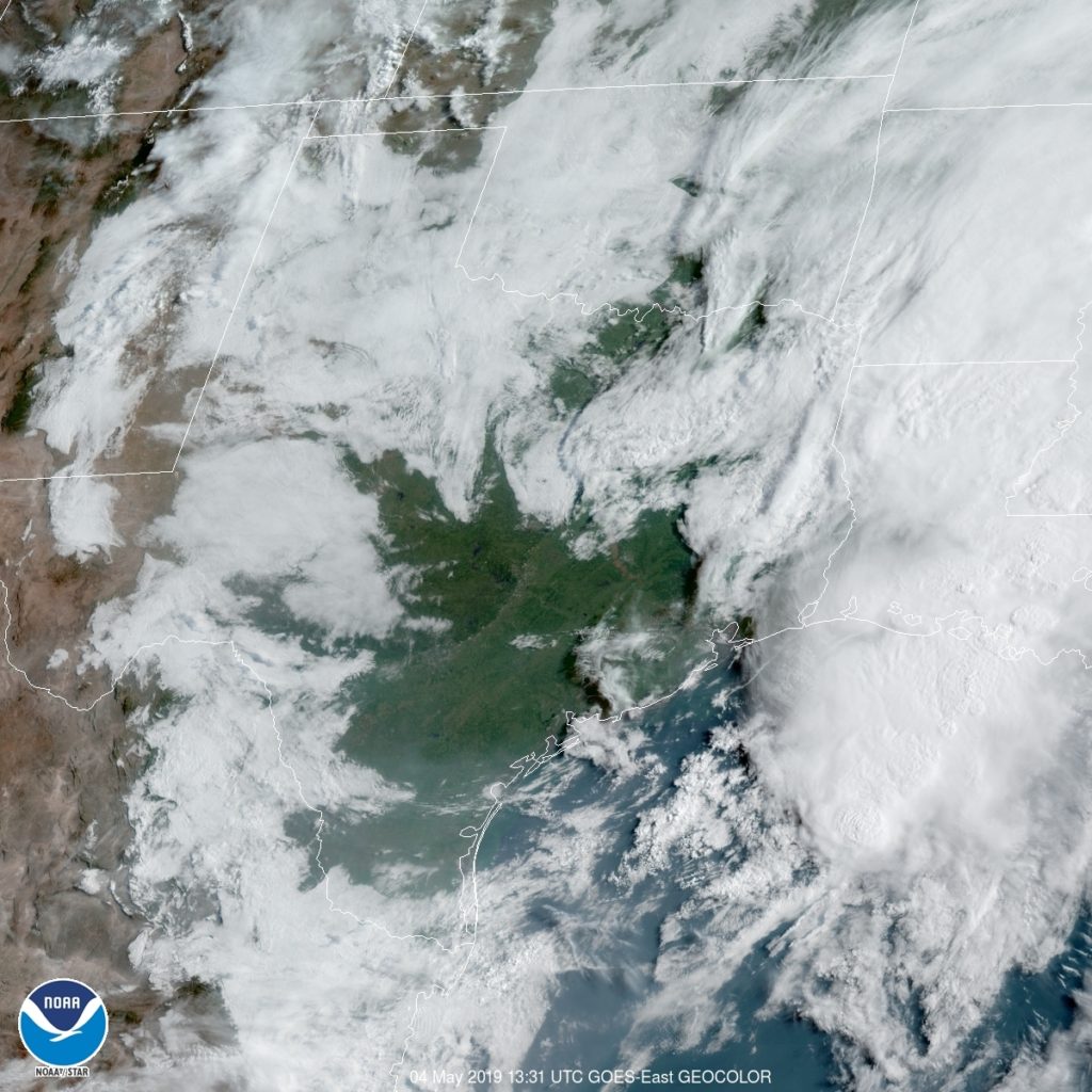
Whenever we can talk about inclement weather in the Plains, that usually means a steady threat of showers somewhere along the Gulf Coast. Is that place Corpus Christi for the next couple of days?
At 1051PM, CT, Corpus Christi was reporting a temperature if 75 degrees with mostly cloudy skies. There was smattering of clouds along the coast reflecting an onshore flow feeding thunderstorms along the dryline over west Texas. While there is indeed a strong system in the northern Plains, the threat of thunderstorms in the southern Plains was tied to the dry line, and is not going to move much further to the east. There isn’t a lot of upper level dynamics at work in the southeastern US, but guidance is pinging on a surface low developing near Del Rio on Tuesday morning. This will tap into the return flow suppling showers further north, and begin to follow the same course. This will mean heavier showers and storms over the Corpus Christi region on Tuesday. It will be forced to oblivion as a stronger feature develops along the Colorado-New Mexico border. Tomorrow – Mostly cloudy, High 85, Low 73 Tuesday — Showers and storms, especially early, High 83, Low 75
TWC: Tomorrow – Variable clouds with thunderstorms, especially in the afternoon. High 83, Low 73 Tuesday – Thunderstorms likely, especially in the morning…and becoming windy High 84, Low 74
AW: Tomorrow – A shower in the morning, then a few strong t-storms; storms can bring flooding and damaging winds High 84, Low 71 Tuesday – Mostly cloudy; a shower or thunderstorm around, breezy and humid High 84, Low 72
NWS: Tomorrow – Showers and thunderstorms likely, mainly after 1pm. Cloudy High 83, Low 75 Tuesday – A 40 percent chance of showers and thunderstorms. Mostly cloudy High 85, Low 75
WB: Tomorrow – Mostly cloudy. A slight chance of showers and thunderstorms in the morning, then a chance of showers and thunderstorms in the afternoon. High 82, Low 76 Tuesday – Mostly cloudy with a 40 percent chance of thunderstorms, High 82, Low 76
FIO: Tomorrow – Mostly cloudy with scattered storms, High 84, Low 74 Tuesday – Mostly cloudy with scattered storms, High 85, Low 75
FIO: Tomorrow – Light rain in the afternoon. High 82, Low 74 Tuesday – Rain starting overnight, continuing until morning. High 83, Low 76
Here is the satellite, with interior Texas looking clear, but a line of storms near the Big Bend.
Today we head down south to see what’s in store for the weekend in Annison, AL! This weekend marks the 8th anniversary of the 2011 Super Outbreak, will they have a quiet weekend to reflect, or will they have to keep their eyes on the sky once again?
At 1053pm CDT, the temperature at Anniston, AL was 54 degrees under fair skies. High pressure is sitting over the Deep South, and should keep an area of low pressure off to the north (which will bring snow to MN/WI/IL) so beautiful weather is in store for Saturday! The tail end of the cold front associated with the aforementioned low pressure system sags into the Deep South for Sunday. While mostly cloudy skies are expected for much of the day, only a couple of isolated showers will push far enough south to threaten the Anniston area. If anything does impact the area, it should be short lived. Overall, a very nice weekend is in store, scores better than that fateful day in 2011.
Saturday: Sunny and beautiful. High 79, Low 46.
Sunday: An isolated afternoon shower possible. High 78, Low 53.
TWC: Saturday: Mostly sunny. High 78, Low 45.
Sunday: Isolated thunderstorms. High 78, Low 56.
AW: Saturday: Plenty of sun; beautiful. High 77, Low 43.
Sunday: A passing morning shower. high 78, Low 55.
NWS: Saturday: Sunny. High 78, Low 48.
Sunday: Slight chance of afternoon thunderstorms. High 80, Low 56.
WB: Saturday: Sunny. High 77, Low 45.
Sunday: Partly cloudy. High 77, Low 56.
WN: Saturday: Sunny. High 78, Low 48.
Sunday: Partly cloudy with isolated storms. High 80, Low 56.
FIO: Saturday: Partly cloudy starting in the evening. High 78, Low 47.
Sunday: Partly cloudy until night. High 77, Low 57.
It’s a fairly clear night across the region, and looks to be that way for much of the weekend!
Everyone everywhere says “if you don’t like the weather here, wait for 15 minutes” or something like that. Denver, though, is perhaps the most variable city in the country and we get to forecast for it! Joy.
At 1005AM, MT, Denver was reporting clear skies and a temperature of 59 degrees. These conditions belied an increasingly active p, Low attern in the northern Rockies, as a deepening trough is going to bring some precipitation to the higher terrains this afternoon and evening. It is a shallow amplitude feature and will sweep through the region quickly. There may be a splash of precipitation on Saturday morning. The jet stream at this moment is shaped like a w, and the second lobe will strafe the northern Rockies on Sunday. As the trough emerges in the northern Plains, surface low pressure will develop, with a cold front tailed into the Denver region. This is he most likely time for the area to see wet weather this weekend, with a few afternoon thunderstorms, particularly east of town, a strong possibility. Tomorrow – A bit of morning drizzle, then clearing, High 69, Low 47 Sunday – Late rain and thunderstorms, High 71, Low 42 (late)
TWC: Tomorrow – Sunshine and some clouds. A stray shower or thunderstorm is possible. High 72, Low 48 Sunday – A mix of clouds and sun early, then becoming cloudy later in the day. A stray shower or thunderstorm is possible. High 74, Low 51
AW: Tomorrow – sunshine and some clouds; comfortable High 70, Low 47 Sunday – Times of clouds and sun, a thunderstorm around in the afternoon High 72, Low 44
NWS: Tomorrow – Mostly sunny High 72, Low 49 Sunday – A 20 percent chance of showers and thunderstorms after noon. Partly sunny, High 73, Low 49
WB: Tomorrow – Partly Cloudy (late rain), High 69, Low 49 Sunday – Mostly cloudy with a 20 percent chance of thunderstorms, High 70 Low 47
WN: Tomorrow – Mostly sunny, High 72, Low 49 Sunday – Partly cloudy with isolated storms, High 73, Low 49
FIO: Tomorrow – Partly cloudy until morning. High 72, Low 49 Sunday – Partly cloudy starting overnight. High 77, Low 51
As is only fitting with Denver these forecasts are all over the map.
I don’t know how Savannah got it’s name. It’s spelled different than the African savannas. Maybe it’s just because it’s so danged hot, just like a savanna. The extra h is for “humid”.
At 1153AM, ET, Savannah was reporting a temperature of 83 degrees with clear skies and a relatively manageable dew point of 59 degrees. There is a jet streak over the northern Gulf of Mexico which is at present providing the nearest cloud cover, as well as the nearest inclement weather, which is developing over east Texas and promises some headaches before the week is through in Savannah. Low pressure is developing in East Texas with a jet streak that will phase into a broader jet trough that extends into the Canadian Prairies. Expect Thursday to remain fairly tranquil, if hot and humid, but showers and storms will be primed to arrive on Friday morning. The association with the broader trough will mean less organization in the storms over Georgia, and the pivoting nature of most high amplitude waves will reduce the chance of a real influx of cold air Friday evening. It will still rain and potentially storm a bit, but Friday would be much worse if these two features didn’t merge. Tomorrow – Mostly sunny, increasing clouds, High 84, Low 63 Friday – Rain, maybe some thunder, generally clearing out in the afternoon, High 82, Low 64
TWC: Tomorrow – Partly cloudy skies in the morning will give way to cloudy skies during the afternoon. High 87, Low 62 Friday – Showers in the morning, then partly cloudy in the afternoon. Thunder possible. High 81, Low 67
AW: Tomorrow – Partly sunny; warm High 87, Low 61 Friday – More clouds than sun, a couple of showers and a thunderstorm; not as hot High 82, Low 65
NWS: Tomorrow – Mostly sunny,High 86, Low 64 Friday – A chance of showers and thunderstorms, then showers likely and possibly a thunderstorm after 7am. Cloudy, High 80, Low 68
WB: Tomorrow – Mostly sunny, High 83, Low 63 Friday – Showers with a chance of thunderstorms, High 83, Low 67
WN: Tomorrow – Mostly sunny, High 86, Low 64 Friday – Mostly cloudy with showers likely, High 80,Low 68
FIO: Tomorrow – Mostly cloudy starting in the afternoon. High 83, Low 61 Friday – Mostly cloudy until afternoon. High 81, Low 66
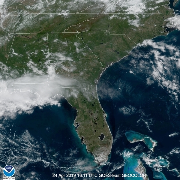
Forecast.iois so bold as to think this system is going to dissipate before it even arrives on the Georgia Coast. Here is the satellite imagery with clouds over the northern Gulf.
For it’s small size, the state of Massachusetts is a compelling weather state. From the exposed Cape Cod to the mountains of the western Berkshires, there are a lot of different scenarios at work. It’s a difficult place to get a handle on for meteorologists, and not just because Massachusetts is hard to spell.
At 3:53PM, ET, Springfield was reporting a temperature of 67 degrees with overcast skies and a brisk south wind. Low pressure over western Pennsylvania was becoming quite occluded, with warm air surging up the east coast and pushing the occluded/cold front offshore. An inverted trough was brining general rain showers to the eastern Great Lakes, and would be drifting through New England through today. The upper level trough will be overridden by a more laminar flow through eastern Canada. The surface low pressure is going to continue to weaken and lose momentum as it slides into New England. Still, a little bit of shower activity will sneak in tomorrow, and the system will revitalize over the ocean and increase the chance for rain and thunder through the day on Monday. Tomorrow – Scattered showers, High 70, Low 54 Monday – Mor overcast with a better chance for rain, High 67, Low 48
TWC: Tomorrow – Cloudy. Slight chance of a rain shower. High – 67, Low 54 Monday – A mix of clouds and sun in the morning followed by cloudy skies during the afternoon. Slight chance of a rain shower. High 68, Low 48
AW: Tomorrow – Times of clouds and sun High 67, Low 52 Monday – Periods of rain High 66, Low 47
NWS: Tomorrow – A chance of showers, mainly before 9am. Mostly cloudy, High 66, Low 52 Monday – Showers likely, mainly after 2pm. Mostly cloudy, High 66, Low 48
WB: Tomorrow – Mostly cloudy. A chance of showers in the morning, High 65, Low 54 Monday – Showers likely, High 65, Low 46
WN: Tomorrow – Cloudy with heavy showers, High 66, Low 55 Monday – Nostly cloudy with light showers likely High 66, Low 48
FIO: Tomorrow – Mostly cloudy throughout the day. High 68, Low 54 Monday – Mostly cloudy throughout the day. High 68, Low 48
Showers earlier today encircled the region, but looked ominous south of Long Island.
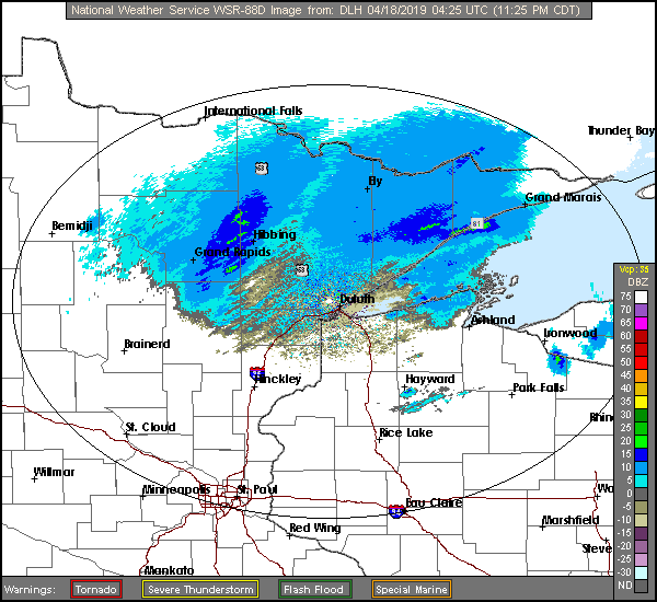
It’s the middle of April, and, disgusting though it may sound, we can’t officially exclude snow from the forecast. Not without a thorough examination, anyway.
At 416PM, CT, Duluth was reporting a temperature of 41 degrees with drizzle and a brisk northwest wind. The temperature across the border in Superior, where wind was more directly coming off the Lake of the same name, was only in the mid 30s. No snow is presently being reported in northwest Wisconsin, but it is certainly not out of the question as cold air continues to filter in. Low pressure will track from southeast Minnesota, through central Wisconsin and into northern Michigan, which will be near enough to Duluth that cold air won’t really sneak in until late in the game. There will be a little bit of leftover moisture overnight when the temperature profile is most likely to permit snow in the early morning hours tomorrow. There will be a quiet period Thursday afternoon, followed by a very pleasant day on Friday. An area of low pressure moving through northern Saskatchewan will drag warmer air north by Friday evening. Tomorrow – Cloudy with drizzle in the morning, then sunny, High 51, Low 37 Friday – Sunny and warmer, High 60, Low 36
TWC: Tomorrow – Cloudy with light rain early. Snow may mix in High 51, Low 36 Friday – Sunny skies High 56, Low 31
AW: Tomorrow – Mostly cloudy, a brief shower or two, High 49, Low 36 Friday – Mostly sunny; not as cool High 56, Low 33
NWS: Tomorrow – Rain likely before 7am, then showers likely, mainly between 7am and 2pm. Mostly cloudy, High 49, Low 37 Friday – Sunny, High 57, Low 32
WB: Tomorrow – Mostly cloudy. ain showers likely in the morning then a chance of rain showers in the afternoon, High 51, Low 38 Friday – Sunny, high 57, Low 33
WN: Tomorrow – Mostly cloudy with light showers likely, High 48, Low 37 Friday – Sunny, High 57, Low 32
FIO: Tomorrow – Mostly cloudy throughout the day. High 54, Low 40 Friday – Partly cloudy overnight. High 63, Low 36
Forecast.io went way warmer than the rest of the group, suggesting faith in model guidance. Makes sense since it is a computer algorithm. I captured the radar much later than I started the forecast, but there is still a bit of light rain in the Arrowhead of Minnesota.
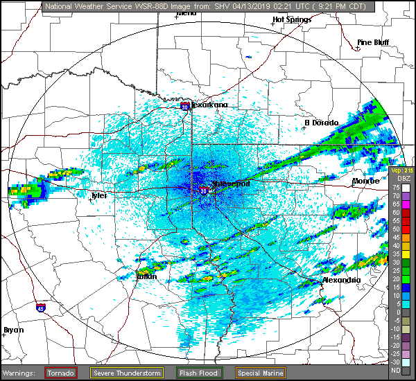
Texarkana was named after three states it is near. It straddles the Texas-Arkansas border, and isn’t far from Louisiana. Sure, it’s closer to Oklahoma, but Texarklahomana is unwieldy.
At 953PM, CT, Texarkana was reporting a temperature of 59 degrees with clear skies. An oscillating boundary over the region is beginning to pivot back north as an area of low pressure develops over the Big Bend area of Texas. The front had pushed south, associated with a strong system now north of the Great Lakes, but the base of the parent trough is over Texas, and fostering development at the tail of the original front. Texarkana looks to be directly in the line of fire for some strong weather tomorrow. Heavy rain with strong thunderstorms will be possible throughout the day, with the best chance coming in the late morning. Because the activity is expected to arrive so early, Texarkana may avoid a particularly tough fate, which is more likely to the southeast, where a “Moderate Risk” of severe weather is being forecast. The dynamics of the system, particularly the inherent vorticity and widespread instability suggest that this storm could result in a large tornado outbreak. Overcast skies and the chance for light rain will continue through the early morning on Sunday, but clearing skies will arrive by lunch time and continue for the remainder of the weekend. Tomorrow – Rain with strong thunderstorms, High 64, Low 56 Sunday – Scattered showers early, then clearing, High 62, Low 45
TWC: Tomorrow – Variable clouds and becoming windy with strong thunderstorms. Damaging winds, large hail and possibly a tornado with some storms. High 59, Low 56 Sunday – Cloudy skies early, then partly cloudy in the afternoon. High 64, Low 45
AW: Tomorrow – Rain and severe thunderstorms; storms can bring flooding, hail, damaging winds and even a tornado High 64, Low 56 Sunday – Some clouds, then sunshine; breezy and cool High 61, Low 45
NWS: Tomorrow – Showers and thunderstorms. Some storms could be severe, with large hail and damaging winds High 65, Low 56 Sunday – A 20 percent chance of showers before 1pm. Cloudy, then gradually becoming mostly sunny High 62, Low 47
WB: Tomorrow – Showers and thunderstoms. Some thunderstorms may be severe with damaging winds, large hail and tornadoes in the afternoon. High 59, Low 57 Sunday – Mostly cloudy with a 20 percent chance of showers in the morning then partly cloudy in the afternoon, High 61, Low 47
WN: Tomorrow – Cloudy with heavy thunderstorms, High 65, Low 56 Sunday – Partly cloudy with isolated showers, High 62, Low 47
FIO: Tomorrow – Rain starting overnight and windy starting in the morning, continuing until afternoon. High 59, Low 55 Sunday – Mostly cloudy until evening. High 64, Low 45
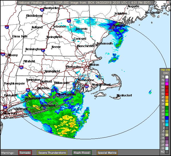
Here is a look at radar imagery of banded showers across the Ark-La-Tex. Below is a Facebook live event from Todd Warren, a meteorologist out of of NBC in Texarkan/Shreveport looking at the severe threat for tomorrow.