Oklahoma City, Oklahoma

The first forecast for December is on its way, and we’re going to one of the weather capitals of the country.

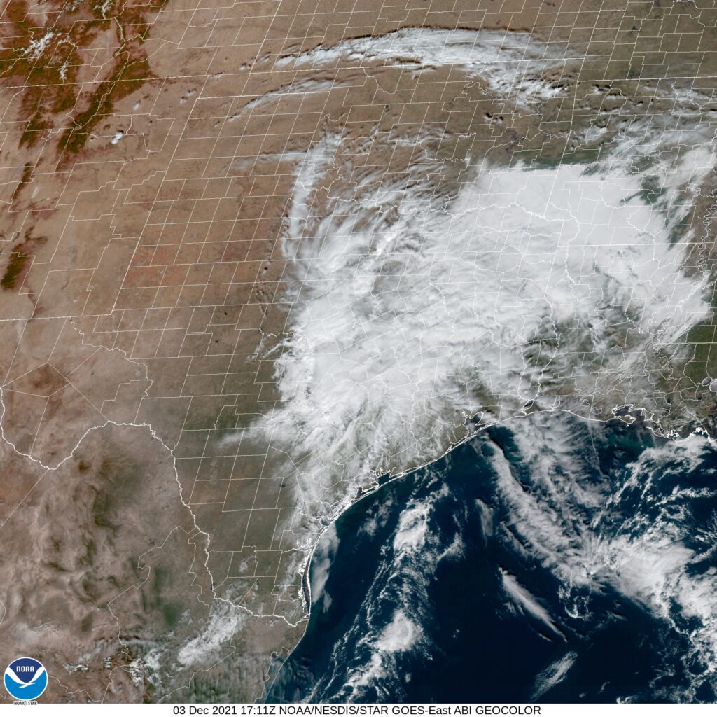
At 1053AM, CT, Oklahoma City was reporting a temperature of 67 degrees. There was a splotch of clouds over the Oklahoma City airport, but the rest of the region was seeing clear skies. Lingering moisture associated with the return flow at the back end of previous ridge led to morning haze and fog across the Gulf Coast, but generally laminar flow over the country is aiding in the development of weak low pressure in Texas. It is propelling clouds and moisture north into Oklahoma.
As the strong seasonal jet, presently along the Canadian border begins to trough in the Canadian Prairies, a deep area of low pressure will emerge in the northern High Plains and the extra agitation will potentially trigger some light rain later in the day on Saturday. As the feature shifts to the east into the Great Lakes, the clouds will clear in order to lead to a warmer afternoon, but the beginning of next week will be on the colder side.
Tomorrow – Mostly cloudy with a little bit of drizzle, High 62, Low 45
Sunday – Warmer and clearer late, brisk in the evening. High 71, Low 44

TWC: Tomorrow – Mostly cloudy. Slight chance of a rain shower. High 59, Low 46
Sunday – Sunny. Becoming windy late. High 73, Low 46

AW: Tomorrow – Mostly cloudy and cooler High 61, Low 46
Sunday – Breezy in the morning; otherwise, mostly sunny and milder High 73, Low 46

NWS: Tomorrow – Mostly cloudy, High 59, Low 49
Sunday – Sunny, High 73, Low 47

WB: Tomorrow – Mostly cloudy, cooler, High 58, Low 48
Sunday – Mostly sunny, High 72, Low 47

WN: Tomorrow – Mostly cloudy, High 59, Low 49
Sunday – Mostly sunny, High 72, Low 47

FIO: Tomorrow – Mostly cloudy throughout the day. High 62, Low 46
Sunday – Clear throughout the day. High 72, Low 45

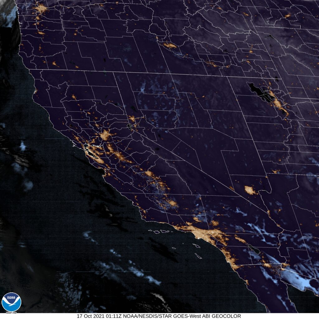
The temperature forecast was all over the map, model wise, but forecast outlets really converged. Here is a look at this afternoon’s satellite imagery, showing clouds on the way.

San Antonio, Texas

Every time I think of San Antonio, I find it is in a much further south location than I remember. It’s a big city that is totally different than any of the other big Texas towns.

At 951PM, CT, San Antonio was reporting overcast skies with a temperature of 51 degrees. Dew points were nearly 50 degrees across the region as well, and some early fog was settling into the region. Low pressure had become established just offshore from Texas, and was helping to generate heavy rain in East Texas, with something resembling a feeder band arcing around towards Amarillo and Lubbock. The low was developed near the right entrance of a jet streak, and at the tail of a surface trough, and is not tropical in nature.
As the jet shifts away, the low will disintegrate into the Gulf, while high pressure develops in the southern US. The surface pressure ridge will be transient, though upper level support will remain in place. Westerly flow across the southern Rockies will allow some additional warmth to spread across the region to begin the work week.
Tomorrow – Morning clouds and fog, followed by a nice afternoon, High 68, Low 48
Monday – Sunny, High 73, Low 44

TWC: Tomorrow – Sunshine and clouds mixed High 71, Low 46
Monday – Sunny skies. High 72, Low 44

AW: Tomorrow – Warmer with times of clouds and sun; ideal weather for one of the busiest travel days of the year High 70, Low 46
Monday – Comfortable with plenty of sunshine High 72, Low 43

NWS: Tomorrow – Mostly sunny, High 68, low 47
Monday – Sunny High 70, Low 44

WB: Tomorrow – Not as cool, Partly cloudy, High 67, low 46
Monday – Sunny, High 70, Low 43

WN: Tomorrow – Partly cloudy, High 68, Low 47
Monday – Mostly sunny, High 70, Low 44

FIO: Tomorrow – Partly cloudy throughout the day. High 69, Low 46
Monday – Clear throughout the day. High 72, Low 43

Quite a bit of rain is showing up on radar, but none of it looms for San Antonio.

Kennewick, Washington

The western US tends to get left behind in the weather coverage, unless it’s fire season. That has changed in the past couple of weeks, with the so called atmospheric river emptying on the Pacific Northwest. Are more headlines in the future?

At 706PM, PT, Kennewick was reporting mostly cloudy skies with a temperature of 33 degrees. The overcast was thanks to a bit of upslope on the eastern exposure of the Cascades, with flow being drawn northward towards the latest system which has arrived over British Columbia. The Pacific Northwest is in the warm sector of this feature, and if the clouds erode early tomorrow, things should warm up decently tomorrow in Kennewick.
The low will move northward, and delay the arrival of the associated cold front. Kennewick may be cloudy tomorrow morning, but ultimately it will be dry tomorrow. The front will arrive Monday evening on the coast, but moisture will fail to traverse the Cascades. There will be a warm up ahead of the arrival, even without any frontal passage, at least not until Tuesday.
Tomorrow – Cloudy early, becoming sunnier, High 40, Low 30
Monday – Sunnier and a bit warmer, High 43, Low 28

TWC: Tomorrow – Mostly cloudy skies. High 41, Low 29
Monday – Some clouds in the morning will give way to mainly sunny skies for the afternoon. High 45, Low 29

AW: Tomorrow – Partly sunny High 38, Low 28
Monday – Partly sunny; quiet weather for early holiday travelers High 42, Low 28

NWS: Tomorrow – Patchy fog before 10am. Otherwise, mostly cloudy High 40, Low 30
Monday – Patchy fog before 10am. Patchy freezing fog before 7am High 42, Low 29

WB: Tomorrow – Partly sunny. Areas of freezing fog and patchy fog in the morning, High 39, Low 30
Monday – Partly sunny, areas of fog and patchy freezing fog, High 42, Low 29

WN: Tomorrow – Mostly cloudy, High 40, Low 30
Monday – Partly cloudy, High 42, Low 29

FIO: Tomorrow – Mostly cloudy throughout the day. High 41, Low 31
Monday – Partly cloudy throughout the day. High 44, Low 28

Between kids that don’t want to sleep tonight and just general attenton span issues, it took 4 hours to write this bad boy. Yikes. Here is the imagery of the region. Look at how narrow the patch of clouds is in south central Washington, just enough to mess with Kennewick.

Terre Haute, Indiana

Last week, my alma mater, the Purdue Boilermakers, defeated the local school from Terre Haute, the Indiana State Sycamores. As a consolation prize, let’s give them a forecast.

At 1053AM, ET, Terre Haute was reporting clear skies with a temperature of 35 degrees. High pressure is lodged in the middle of the country, and while a westerly flow of the Lake was leading to some snow to the north, Terre Haute itself was well outside the lake effect fetch.
The subtropical jet is running through the southern part of the Continental US, assisting the ridge in the eastern part of the country, but the Arctic jet is strengthening, and a troughal exit region will develop over the Upper Mississippi Valley, as a cold front emerges at the surface. This is tied to an area of low pressure shifting through the Yukon and Northwest Territories. Showers, to be chased out by chilly air will develop on Sunday morning, with the late afternoon becoming clearer. High pressure will build in again for the holiday week.
Tomorrow – Sunny, High 50, Low 30
Sunday – Some clouds with a little rain in the morning, High 49, Low 36

TWC: Tomorrow – Cloudy skies early, then partly cloudy in the afternoon High 51, Low 31
Sunday – Cloudy and damp with rain in the morning…then becoming partly cloudy. High 53, Low 40

AW: Tomorrow – Periods of clouds and sun High 50, Low 30
Sunday – Cloudy in the morning with a bit of rain, then intervals of clouds and sunshine in the afternoon High 52, Low 38

NWS: Tomorrow – Mostly cloudy, High 51, Low 31
Sunday – A 30 percent chance of showers before 1pm. Mostly cloudy, High 54, Low 37

WB: Tomorrow – Mostly cloudy, High 49, Low 31
Sunday – Mostly cloudy with a 40 percent chance of rain showers in the morning then partly cloudy in the afternoon, High 50, Low 36

WN: Tomorrow – Mostly cloudy, high 51, Low 31
Sunday – Mostly cloudy with light rain showers, High 54, Low 42

FIO: Tomorrow – Overcast throughout the day. High 52, Low 31
Sunday – Rain in the morning and afternoon. High 53, Low 35

A lot of cold air north of Terre Haute is leading to clouds, but there isn’t actually a lot going on up there.

Weirton, West Virginia

We are getting way up in the West Virginia Panhandle for tonight’s forecast. There is a nasty autumnal storm moving through the Plains, which will only bring the same for the Ohio Valley this week. But how nasty might it get?

At 953PM, ET, the Weirton area was reporting a temperature of 53 degrees with clear skies. The eastern US is under high pressure, but an active area of low pressure threatens to change the pattern. This feature is in the early part of it’s life cycle, existing as an elongated pressure trough centered from Minnesota to eastern Oklahoma. The jet exit region of the trough fostering this low will strengthen and course the system to occlude and take on the more typical comma shape of strong transitional season systems.
Already, the system is ejecting some high cirrus that is nearing northern West Virginia, and that will ensure that gray skies are the order of the day tomorrow, even before precipitation arrives. By tomorrow evening, the system will be mature and the first spots of rain will arrive. The front associated with this system will arrive with gusto between about 8 and 10pm, with rain and breezy conditions likely. The precipitation will clear out fairly quickly and with a shot of crisper air. Friday will be cooler but with more sun.
Tomorrow – Cloudy, with rain, and maybe an isolated rumble of thunder late, High 68, Low 47
Friday – Rain early, then cool, High 55, Low 45

TWC: Tomorrow – Cloudy. Slight chance of a rain shower. High 71, Low 46
Friday – Except for a few afternoon clouds, mainly sunny (early rain). High 58, Low 45

AW: Tomorrow – Warm; sun and areas of high clouds in the morning, becoming cloudy in the afternoon with a passing shower High 69, Low 43
Friday – Some sun, then turning cloudy, breezy and cooler (Early rain) High 57, Low 45

NWS: Tomorrow – Partly sunny, (Late rain) High 69, Low 45
Friday – Mostly sunny (early rain) High 57, Low 43

WB: Tomorrow – Partly sunny. A slight chance of showers in the afternoon. High 68, Low 48
Friday – Mostly sunny (Early rain), High 55, Low 46

WN: Tomorrow – Partly cloudy with scattered showers, High 68, Low 44
Friday – Mostly sunny, High 56, Low 42

FIO: Tomorrow – Rain overnight and in the evening. High 69, Low 45
Friday – Rain overnight. High 58, Low 44

It’s going to rain, but at least it will have the decency to do so overnight. Pretty good agreement all around!

Portland, Maine

We are forecasting for Portland, Maine mere days after verifying a forecast for Portland, Oregon. I have nothing to add to that, but felt as though I needed to acknowledge it.

At 751PM, ET, Portland was reporting a temperature of 42 degrees with clear skies. In what can only be described as an upset victory, New England was entirely under clear skies on this early November evening. The most recent Gulf Stream storm was well off the coast, and actually helping to inhibit moisture for the next system working its way across Hudson Bay.
That feature over Hudson Bay, while limited in potential precipitation, is still backed by good upper level support and substantial surface reflection in terms of temperature and lack of moisture. Tonight will ultimately be a foggy one for Portland and most of coastal Maine, however the cold front will bring first a spot of light rain overnight Tuesday to Wednesday, with a chance for cooler crisper air after the morning low clouds clear out on Wednesday.
Tomorrow – AM fog, then mostly sunny, Light rain possible rain before midnight High 58, Low 37
Wednesday – Light rain through the morning, becoming sunny, High 57, Low 38

TWC: Tomorrow – Plentiful sunshine. High 60, Low 37
Wednesday – Showers in the morning, then partly cloudy in the afternoon. High 55, Low 42

AW: Tomorrow – Mostly sunny; great day to be outside High 57, Low 35
Wednesday – Clouds breaking, a shower possible High 55, Low 41

NWS: Tomorrow – Sunny High 60, Low 40
Wednesday – Cloudy through mid morning, then gradual clearing, High 55, Low 40

WB: Tomorrow – Mostly cloudy, High 59, Low 32
Wednesday – Mostly cloudy in the morning, then clearing (rain early) High 53, Low 39

WN: Tomorrow – Mostly sunny, High 60, Low 41
Wednesday – Partly cloudy with isolated showers, High 55, Low 45

FIO: Tomorrow – Clear throughout the day. High 60, Low 39
Wednesday – Light rain overnight and in the morning. High 57, Low 46

It’s going to be a nice couple of days in Portland, and the rain will even have the decency to come overnight. Look how beautiful New England is tonight.

Roanoke, Virginia

Good evening! Let’s get this weekend forecast off the ground, shall we?

At 1254AM, ET, Roanoke was reporting clear skies and a temperature of 36 degrees. With clear skies and dew points sub freezing, frost is a foregone conclusion tomorrow morning. A sharp trough moving into the area is bringing cold air to he region, but more significantly outside of Roanoke, will aid in the development of a low in the Bight of Georgia, which will prove impactful later this weekend.
As the system develops this weekend, it will reinforce the chilly air invading the Roanoke area. There may be a few scattered clouds thanks to the flow over the Appalachians, but there is no threat of the feature moving onshore far enough to bring rain or snow to Roanoke. Expect cool temperatures but generally sunny skies through the weekend, but rain, potentially flooding rain and high surf in Georgia and South Carolina, not that far away. The trough will flatten a bit on Sunday, allowing some warmer temperatures to conclude the weekend.
Tomorrow – Partly cloudy, High 53, Low 30
Sunday – Partly cloudy, cool and crisp, High 61, Low 34

TWC: Tomorrow – A mix of clouds and sun early, then becoming cloudy later in the day. High 55, Low 30
Sunday – Mostly cloudy skies early, then partly cloudy in the afternoon. High 62, Low 36

AW: Tomorrow – Times of sun and clouds High 54, Low 34
Sunday – Partly sunny High 62, Low 38

NWS: Tomorrow – Mostly sunny High 54, Low 29
Sunday – Mostly cloudy, then gradually becoming sunny, High 62, Low 38

WB: Tomorrow – Mostly sunny, High 54, Low 33
Sunday – Mostly sunny, High 62, Low 35

WN: Tomorrow – Partly cloudy, High 54, Low 29
Sunday – Partly cloudy, High 62, Low 38

FIO: Tomorrow – Mostly cloudy throughout the day. High 55, Low 30
Sunday – Mostly cloudy throughout the day. High 62, Low 34

The pattern is unkind specifically to Charleston lately. Persistent troughing and development of low pressure over the Bight of Georgia will continue through the early part of the week. Sheesh.

Sherman, Texas

Happy Election Day, and Happy November everyone. We’re going to mosey just south of the Red River and check out Sherman.

At 815PM, CT, Sherman was reporting a temperature of 49 degrees with overcast conditions. A swath of rain was falling just to the south, between Sherman-Denison and I-30, and generally drifting eastward. Scattered showers extended as far to the west as Wichita Falls, so even though the heaviest rain is probably over for the night, more rain is likely on the way tonight. An upper level trough is represented by a notch within a surface ridge, with the ridging expected to overtake the disturbance through the day tomorrow. The rain tonight will continue through late morning, perhaps, but a clear, cool afternoon is anticipated.
With high pressure reestablished under an early winter trough, Sherman should see some tastes of normal to slightly below normal temperatures for the season.
Tomorrow – Light showers early, then clearing and cool, High 50, Low 45
Thursday – Partly cloudy and chilly in the morning, high 56, Low 40

TWC: Tomorrow – Showers in the morning, then cloudy in the afternoon High 48, Low 45
Thursday – Mostly cloudy skies early will become partly cloudy later in the day. High 57, Low 42

AW: Tomorrow – Cool with occasional rain and drizzle High 51, Low 47
Thursday – Clouds giving way to some sun and cool High 57, Low 42

NWS: Tomorrow – Showers and possibly a thunderstorm before 1pm, then a slight chance of showers between 1pm and 3pm. High 49, Low 47
Thursday – Partly sunny, High 55, Low 43

WB: Tomorrow – Showers and perhaps a thunderstorm in the morning, then a slight chance of showers in the afternoon, High 49, Low 47
Thursday – Mostly cloudy in the morning, then becoming partly sunny, High 56, Low 42

WN: Tomorrow – Cloudy with light showers and isolated thunderstorms, High 49, Low 47
Thursday – Partly cloudy, High 55, Low 43

FIO: Tomorrow – Rain until afternoon. High 52, Low 47
Thursday – Partly cloudy throughout the day. High 57, Low 41

I’m drier and clearer than the rest, and it shows in my temperature forecasts. It looks a little damp tonight.

Portland, Oregon

Our first forecast of the workweek, and perhaps the last of October (I don’t know that, just how slowly I operate) takes us to the teeth of a bomb cyclone/atmospheric river, and a whole lot of climate buzzwords.

At 553AM, PT, Portland was reporting a temperature of 52 degrees with light rain. The Portland metropolitan area was still getting soaked, The rainfall in the Pacific Northwest is ongoing west of the Cascades, but at a lessened rate than it has over the last few days. The strong system in the Gulf of Alaska has moved towards the Panhandle near Sitka and Juneau, which has decreased the westerly flow, but the low level moisture is still available, and the flow is enough that the Cascades will still see steady precipitation with more intermittent rain in Portland.
While all this is good news, it will take until the middle of the day on Wednesday to really wind down, so occasional breezes and rain will be a fixture today and through the beginning of tomorrow. Wednesday afternoon will be the nicest stretch of the forecast, as a secondary, but weaker reinforcing wave is expected to emerge off the Oregon Coast, arriving overnight Wednesday to Thursday. This feature will take a direct shot at the Olympic Peninsula, but Portland will see more rain and wind, especially in the evening on Thursday as the next round slides ashore. This second round will bring a warmer ridge northward, and some warming should be anticipated late.
Tomorrow – Rain in the morning, a bit of clearing late, High 60, Low 50
Thursday – Rain, maybe a rumble of thunder in the evening, High 65,Low 52

TWC: Tomorrow – Cloudy with occasional light rain in the afternoon. High 57, Low 51
Thursday – Rain showers in the morning will evolve into a more steady rain in the afternoon High 65, Low 53

AW: Tomorrow – A thick cloud cover with a little rain High 58, Low 51
Thursday – Mostly cloudy with a couple of showers HIgh 67, Low 54

NWS: Tomorrow – Showers likely before 2pm, then rain likely after 2pm. Cloudy, High 58, Low 50
Thursday – Rain. High 64, Low 50

WB: Tomorrow – Showers likely until afternoon, then rain likely late in the afternoon, High 55, Low 50
Thursday – Rain, High 64, Low 52

WN: Tomorrow – Mostly cloudy with light showers likely, High 58, Low 50
Thursday – Mostly cloudy with rain, High 64, Low 53

FIO: Tomorrow – Light rain throughout the day. High 60, Low 48
Thursday – Light rain throughout the day. High 62, Low 57

We are all over the place in what we expect will happen in Portland over the next couple of days. I’m very interested in seeing how it all plays out.

Ogden, Utah

I consider myself a geography aficionado. It’s something I am good at, but frankly, I constantly confuse Ogden and Provo. Ogden, if you were curious, is north of Salt Lake City.

At 653PM, MT, Ogden was reporting a temperature of 59 degrees with clear skies. There really weren’t many clouds anywhere across the western United States as residents try to reclaim some autumn after an early shot of snow last weekend.
A fast moving upper level low will rotate through the central Pacific Coast towards Utah, bringing about some clouds to the region, with high elevation snow becoming likely again. Precipitation will arrive on Monday morning, and down by the Lake, Ogden will see only rain. There should be some improvement after sunset, but only at the end of a rainy afternoon.
Tomorrow – Sunny, High 69, Low 41
Monday – Rain through the daylight hours. High 57, Low 42

TWC: Tomorrow – Generally sunny despite a few afternoon clouds, High 70, Low 42
Monday – Cloudy with rain developing later in the day. High 57, Low 44

AW: Tomorrow – Mostly sunny High 69, low 40
Monday – Cooler with clouds and breaks of sun; breezy in the morning with a thunderstorm in spots followed by afternoon showers High 58, Low 41

NWS: Tomorrow – Sunny, High 69, Low 40
Monday – Rain, mainly after 1pm High 56, Low 42

WB: Tomorrow – Sunny in the morning, then becoming partly cloudy, High 67, Low 41
Monday – Breezy. Partly sunny with a slight chance of rain in the morning, then cloudy with rain in the afternoon. High 56, Low 43

WN: Tomorrow – Mostly sunny, High 69, Low 42
Monday – Mostly cloudy with light rain, High 56, Low 50

FIO: Tomorrow – Partly cloudy throughout the day. High 74, Low 43
Monday – Rain until night, starting again in the afternoon, high 63, Low 49

I’m not sure what broker at Forecast.io, but they sure have different forecasts. Forecast lows are all non-standard for Monday, except Weather Nation who don’t have hourly forecasts that deep into the night. The satellite is pretty empty