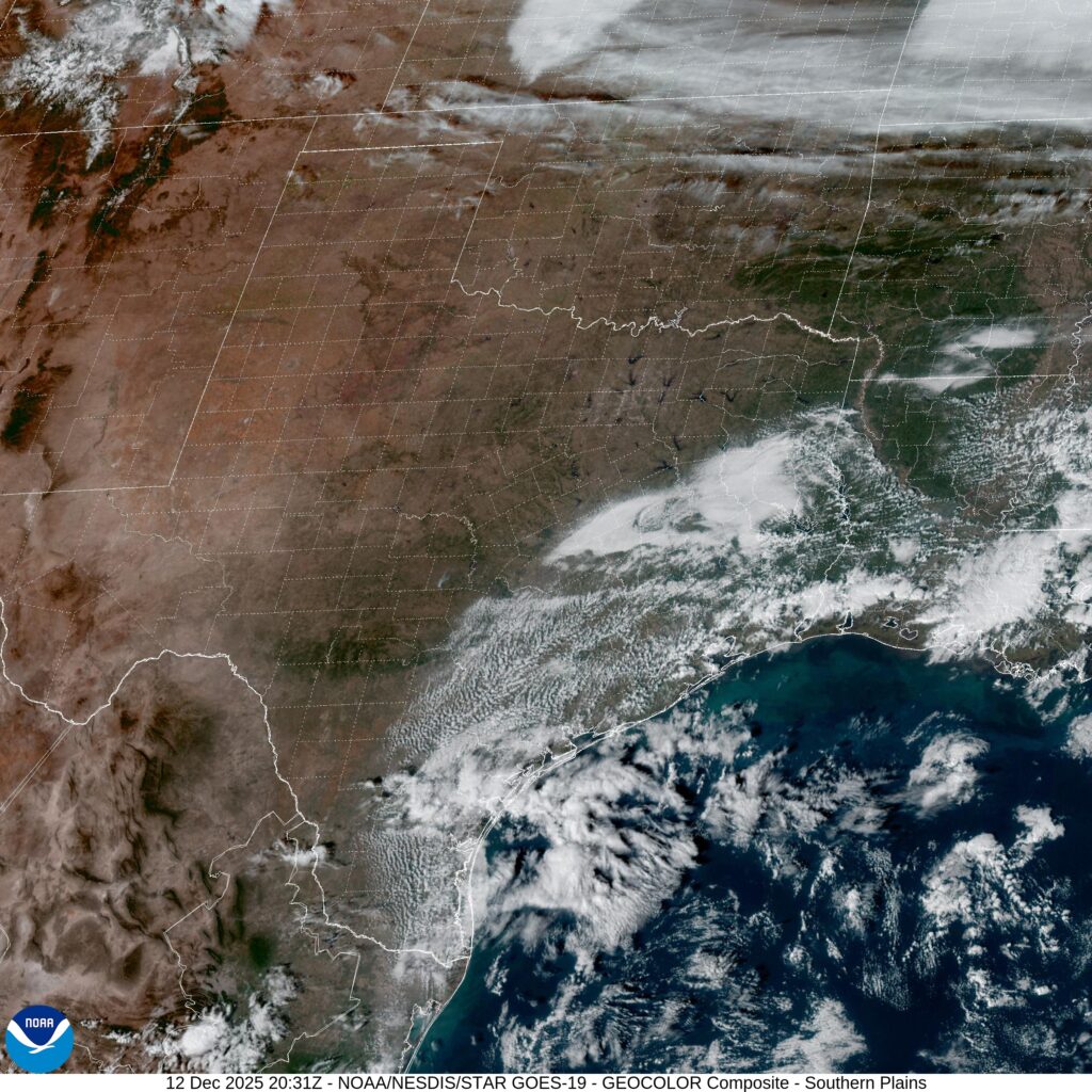
It seemed like a little bit cooler air was going to settle in early to southwestern Oklahoma. There was a chance for a little bit of rain over the holiday weekend, but it was still plenty warm. Saturday was he winning day in Lawton, with dry skies and a cooler temperature that came on Sunday. There wsan’t much rain, just a drizzle, and it came with temperatures that were back up in the upper 80s. It’s what you should expect in Lawton, but it’s still disappointing when the forecast was for something a bit cooler. Accuweather had the warmest forecast and earned victory for the day. Actuals: Saturday – High 81, Low 70 Sunday – .02″ of rain, High 88, Low 69
After bouncing around the middle of the country recently, we will now head to the East Coast, where we will probably see things like “the Gulf Stream” mentioned a few times.
At 454PM, ET, Atlantic City was reporting a temperature of 74 degrees with clear skies. There is a thatch of clouds over Delaware Bay, associated with an upper level trough. There is a jet streak over the western Atlantic, but surface high pressure is keeping things rain free in the mid-Atlantic. There is a bit of moisture in the middle of the country that will struggle to ascend the Appalachians. Low pressure following the Gulf Stream is moving at the eastern periphery of coler air, and the northerly flow in New Jersey will keep the region unseasonably cool. Tomorrow – Mostly sunny, High 74, Low 56 Tuesday – Mostly cloudy, High 76, Low 55
TWC: Tomorrow – Sunshine and clouds mixed High 73, Low 60 Tuesday – Partly cloudy High 74, Low 60
AW: Tomorrow – Partly sunny and windy; a nice afternoon for outdoor activities High 74, Low 62 Tuesday – Nice with plenty of sunshine High 72, Low 61
NWS: Tomorrow – Sunny, High 75, Low 64 Tuesday – Sunny, High 75, Low 62
WB: Tomorrow – Sunny, High 70, Low 64 Tuesday – Sunny, High 72, Low 63
WN: Tomorrow – Mostly sunny, High 74, Low 64 Tuesday – Mostly sunny, High 74, Low 63
CLI: Tomorrow – Light rain showers, High 73, Low 59 Tuesday – Partly cloudy, High 74, Low 59
Looks like south Jersey is in for a good Labor Day. Clouds entering the area are high, and not as threatening as they might look.
Lawton is home to Fort Sill, which also gives us most of the population. The town is in the southwest part of the state, which leaves it in a dryer patch of land this late in the summer.
At 353PM, CT, Lawton was reporting overcast skies with a temperature of 77 degrees. Dew points were also in the upper 60s, making for a rather soupy afternoon. The tail of a cool front was triggering some thunderstorms in Texas, and westerly flow over the Rockies was contributing to a particularly vigorous dry line, leading to severe weather in the Colorado Plains. All the while, an upper level ridge is keeping Oklahoma dry, if a bit on the cloudy side. As the upper level jet streak shifts further to the east, it will weaken greatly. The dry line will press east as well, but without as much momentum. The threat of showers and storms will arrive in southern Oklahoma on Sunday morning. The associated boundary will continue to weaken, and there won’t be any organized shower activity. As the afternoon wears on, the threat will lessen as the former dry line mixes out. The extra clouds will keep temperatures moderated. Tomorrow – Mostly cloudy, High 80, Low 69 Sunday – Scattered showers, mostly cloudy, High 84, Low 68
TWC: Tomorrow – Isolated thunderstorms in the morning, then cloudy skies late High 80, Low 68 Sunday – Showers in the morning, then partly cloudy in the afternoon. High 85, Low 69
AW: Tomorrow – Humid with a shower in places; cloudy in the morning, then intervals of clouds and sunshine in the afternoon High 81, Low 69 Sunday – Humid with sun and some clouds; a thunderstorm in the afternoon High 86, Low 69
NWS: Tomorrow – A 50 percent chance of showers and thunderstorms, mainly after 7am. Mostly cloudy, High 81, Low 68 Sunday – A 50 percent chance of showers and thunderstorms. Mostly cloudy High 83, Low 69
WB: Tomorrow – Mostly cloudy in the morning then becoming partly sunny. A chance of showers with a slight chance of thunderstorms High 78, Low 69 Sunday – Mostly cloudy in the morning then becoming partly sunny. A chance of showers. A slight chance of thunderstorms in the morning then a chance of thunderstorms in the afternoon. High 79, Low 69
WN – Tomorrow – Partly cloudy with scattered showers and isolated thunderstorms, High 80, Low 64 Sunday – Mostly cloudy scattered showers and chance of storms, High 83, Low 68
CLI: Tomorrow – Thunderstorm, High 79, Low 67 Sunday – Light rain showers, High 84, Low 69
It looks like a pretty good holiday weekend is coming up for southwest Oklahoma. Spots of rain, but temperatures are manageable. Not so bad on satellite this afternoon.
Having some minor (I hope) server issues today at Victoria-Weather HQ. That shouldn’t change the weather in Fort Collins, though, right? What can we expect in Northern Colorado this weekend?
At 956AM, MT, Fort Collins was reporting a temperature of 77 degrees with clear skies and a brisk north wind. There is a bit of shower activity across northern Colorado is associated with a cold front appended to an area of low pressure in western Ontario. A leading trough has switched winds to northerly across Fort Collins, but the boundary remained just to the north in southern Wyoming. Shower activity is largely found in the mountains west of Fort Collins and Cheyenne, though there will be some light activity as the day wears on, lasting into the morning tomorrow. As the area of low pressure moves on to the east, high pressure will build in the Plains. In the southwest, warm air will begin to build again, and a laminar flow over the Rockies will lead to a down-slope and lee troughing in the Colorado flatlands. The contrast in air mass will lead to some ridge-riding thunderstorms in eastern Colorado by Sunday, but guidance and intuition suggest that the bulk of the activity will be south of the Palmer Divide, leaving Fort Collins mostly unbothered, but late in the period some activity could press into the area. Tomorrow – Isolated showers, especially early, High 74, Low 60 Sunday – Partly to mostly cloudy, isolated thunder late High 80, Low 57
TWC: Tomorrow – Scattered thunderstorms in the morning. Partly cloudy skies late High 78, Low 61 Sunday – Partial cloudiness early, with scattered showers and thunderstorms in the afternoon High 75, low 51
AW: Tomorrow – Low clouds breaking for some sun with a thunderstorm in one or two spots High 76, Low 60 Sunday – Intervals of clouds and sunshine with a thunderstorm or two in the afternoon High 76, Low 55
NWS: Tomorrow – A chance of showers, with thunderstorms also possible after noon. Mostly cloudy, High 75, low 59 Sunday – Showers likely and possibly a thunderstorm between noon and 3pm, then showers and thunderstorms likely after 3pm. Partly sunny, High 79, low 58
WB: Tomorrow – Mostly cloudy. Chance of showers in the morning then a chance of thunderstorms in the afternoon High 72, Low 60 Sunday – Thunderstorms likely. High 74, low 56
WN: Tomorrow – Mostly cloudy with scattered showers and a chance of storms, High 75, low 59 Sunday – Mostly cloudy with light showers and scattered storms, High 79, Low 58
CLI: Tomorrow – Thunderstorm, High 76, Low 60 Sunday – Thunderstorm, high 78, low 56
Count me in the “not likely” camp on Sunday thunderstorms. Everything right now just looks like it will show up too far to the south. Not today though, here is radar imagery, with showers heading in from Wyoming.
Midland, despite it’s name, is not really in the middle of anything, except, perhaps “nowhere”. Fairly isolated in west Texas, save for a proximity to Odessa. Let’s see if they can look forward to anything more than dust.
At 353PM, CT, Midland was reporting a temperature of 96 degrees with fair skies. Midland was northwest of the dry line, with a dew point in the upper 50s, compared to the dew point in Brownwood and Stephenville, which sat in the 70s. A local eddy was still producing some showers behind the primary dry line, notably over the southeastern corner of New Mexico. The trough related showers and storms over the High Plains will become less active as a storm system in the Canadian Prairie moves towards the northern Great Lakes. Onshore flow from the Gulf will still be present, and showers will be likely over south Texas, but the end of the work week should be dry in Midland. Tomorrow – Mostly sunny, High 100, Low 74 Friday – Mostly sunny, High 99, Low 75
TWC: Tomorrow – Partly cloudy, High 100, Low 74 Friday – Intervals of clouds and sunshine, High 97, Low 76
AW: Tomorrow – Breezy in the morning; otherwise, hot with sunshine mixing with some clouds; High 100, Low 75 Friday – Breezy and very warm with periods of clouds and sunshine High 99, Low 77
NWS: Tomorrow – Sunny, High 98, Low 74 Friday – Sunny, High 97, Low 76
WB: Tomorrow – Sunny, High 97, Low 76 Friday – Sunny, High 94, Low 77
WN: Tomorrow – Mostly sunny, High 98, Low 74 Friday – Mostly sunny, High 97, Low 76
CLI: Tomorrow – Sunny, High 98, Low 74 Friday – Partly cloudy, High 97, Low 75
Those showers in New Mexico dissipated before I took the image of the satellite. But storms in Texas are still roaring tonight, not threatening Midland at all.
Our forecast today is taking us to central Arkansas. It’s not quite the Ozarks, not quite the Mississippi Valley, it’s Pine Bluff!
At 753PM, CT, Pine Bluff was reporting a temperature of 84 degrees, with dew points in the low 70s. The high dew points were not enough to trigger isolated thunderstorms across the region, with a weak upper ridge nosing into the region, suppressing flow in any direction. Guidance is fairly consistent about lee troughing emerging as the week draws to an end. If anything, this will mean even more humidity, this time from the Gulf, rather than augmented by the woods of the Ozarks, and at all levels. While precipitation isn’t expected, there is an increased level of clouds by Friday. Tomorrow – Mostly sunny, high 91, Low 70 Friday – Partly cloudy, High 96, Low 71
TWC: Tomorrow – Sunshine. High 97, Low 71 Friday – Sunshine. High 98, Low 73
AW: Tomorrow – Mostly sunny High 96, Low 70 Friday – Plenty of sunshine High 96. Los 71
NWS: Tomorrow – Sunny, High 96, Low 71 Friday – Sunny and hot, High 97, Low 71
WB: Tomorrow – Sunny. High 94, Low 75 Friday – Sunny. High 92, Low 73
WN: Tomorrow – Mostly sunny, High 96, Low 71 Friday – Mostly sunny, High 97, Low 71
CLI: Tomorrow – Sunny, High 96, Low 71 Friday – Sunny, High 98, Low 72
It looks fairly quiet on radar over Arkansas. Those storms aren’t going to be working north any time soon.
We are on our way to Point Conception, north of LA for this forecast. There were tsunami advisories south of SLO today, which is not something I have seen on an NWS alert map in the past.
At 656PM, PT, San Luis Obispo was reporting clear skies and a temperature of 64 degrees. There was a brisk onshore flow, keeping things comfortable west of the Coastal Range, though it was in the mid-90s on the other side of the mountains. There is a jet streak over central California ensuring onshore flow will be maintained with some vigor, however of greater note is the low clouds lurking offshore. Point Conception is prime territory for morning low clouds and fog, and each of the next to days should feel the impact of the Marine Layer. Tomorrow – morning clouds and fog, High 76, Low 55 Friday – Morning clouds, clearing, High 76, Low 55
TWC: Tomorrow – Partly cloudy skies High 74, Low 54 Friday – Sunshine along with some cloudy intervals. High 75, Low 56
AW: Tomorrow – Clouds giving way to sun High 77, Low 56 Friday – Mostly sunny and nice High 78, Lo 56
NWS: Tomorrow – Patchy fog before 11am. Otherwise, cloudy through mid morning, then gradual clearing, High 75, Low 55 Friday – Patchy fog before 11am. Otherwise, cloudy through mid morning, then gradual clearing High 76, Low 55
WB: Tomorrow – Low clouds and fog in the morning then sunny. High 81, Low 58 Friday – Low clouds and fog in the morning then sunny. High 80, Low 59
WN: Tomorrow – Partly cloudy, High 75, Low 55 Friday – Partly Cloudy, High 76, Low 55
CLI: Tomorrow – Sunny, High 74, Low 56 Friday – Sunny, High 74, Low 58
Wow, one degree different from the NWS forecast. We’ll all feel pretty silly if we are a ways off. Satellite shows the lingering clouds offshore.
Danville lies along the Indiana border, south of Chicago, and deep inside of corn sweat country. Are you ready to swelter?
At 355PM, CT, Danville was reporting a temperature of 91 degrees with clear skies. Importantly, dewpoints were in the low to mid 70s across the regions, making things even more uncomfortable. Lower level forcing is driving a bit of surface development, which is initiating in the High Plains. The moisture that crops up here will then track along the southern edge of a ridge that has emerged over the north central part of the US. There is, as a result, a marginal risk of severe weather for the area tomorrow. There is weak forcing but unstable air. Things may unfold quickly. If things proceed as current longer range models indicate, storms will arrive in Danville and linger into the overnight hours, before exiting town in the predawn of Thursday. If this is another derecho, as have been frequent of late, don’t be surprised if the onset is earlier than currently indicated. Fortunately, the ridge is going to continue to squash further south. It isn’t necessarily enjoying the benefit of cold air, but the air is dryer, and Thursday afternoon, at the very least, will be pleasant. Tomorrow – Rain in the afternoon, with strong thunderstorms possible overnight, High 92, Low 72 Thursday – Early morning thunderstorms, with gusty winds, then much more pleasant, High 79, Low 66
TWC: Tomorrow – A mix of clouds and sun early, then becoming cloudy later in the day. A stray thunderstorm is possible High 91, Low 70 Thursday – Scattered thunderstorms in the morning, then cloudy skies late. High 75, Low 66
AW: Tomorrow – Warm and humid with variable cloudiness; a couple of heavy thunderstorms in the afternoon; storms can bring flash flooding and damaging winds High 89, Low 70 Thursday – Periods of rain and a thunderstorm in the morning; mostly cloudy and humid; heavy downpours can reduce visibility and cause ponding on streets and highways High 74, Low 68
NWS: Tomorrow – 40 percent chance of showers and thunderstorms after 1pm. High 89, Low 72 Thursday – A 50 percent chance of showers and thunderstorms before 1pm. High 77, Low 65
WB: Tomorrow – Patchy fog in the morning. Sunny with a slight chance of showers and thunderstorms in the morning then partly sunny with a chance of showers and thunderstorms in the afternoon. High 93, Low 74 Thursday – Mostly cloudy. A chance of showers and thunderstorms in the morning. High 76, Low 66
WN: Tomorrow – Partly cloudy with a chance of storms, High 89, Low 72 Thursday – Mostly cloudy with a chance of storms, High 78, Low 65
CLI: Tomorrow – Thunderstorm, High 91, Low 71 Thursday – Thunderstorm, High 76, Low 63
Clearly, whatever happens in Danville this week is going to have a real impact. Expect better sleeping this later this week, central Illinois. Satellite with a few clouds by St. Louis before the sun goes down.
We aren’t yet to the peak of monsoon season in the southwest, but it is certainly summer. I expect some good numbers for our forecast outlets, and a toasty temperature read out.
At 1051AM, ET, Phoenix was already reporting a temperature of 98 degrees with clear skies. It would be a hot day again today. While the monsoon season hasn’t gotten fully cranked up, there are afternoon showers and storms erupting along the New Mexico border, with a threat for afternoon activity generally north of Tucson. The synoptic pattern is non existent, which means a persistence forecast is in order. Even if a stray storm wanders into Phoenix, the activity will erupt after peak heating has been achieved, so there won’t be much modification from being the model guidance. Tomorrow – Mostly sunny, High 111, Low 88 Tuesday – Hot, sunny, High 110, Low 85
TWC: Tomorrow – Mainly sunny. High 109, Low 88 Tuesday – Mostly sunny skies. High 107, Low 88
AW: Tomorrow – Hot with hazy sun; wildfire smoke will cause the sky to be hazy High 112, Low 89 Tuesday – Mostly sunny and very warm; wildfire smoke will cause the sky to be hazy High 109, Low 89
NWS: Tomorrow – Sunny, High 109, Low 88 Tuesday – Sunny, High 108, Low 87
WB: Tomorrow – Sunny and hot High 109, Low 87 Tuesday – Mostly sunny. High 109, Low 92
WN: Tomorrow – Mostly sunny, High 109, Low 88 Tuesday – Partly cloudy with isolated storms, High 108, Low 87
CLI: Tomorrow – Sunny, High 109, Low 88 Tuesday – Sunny, High 108, Low 88
I told you that it is monsoon season, but there isn’t anything to show for it on satellite.
It’s a hot on this holiday weekend, with a few scattered showers and storms across the middle of the country. It’s hard to produce a forecast for anywhere right now without giving a thought to the devastating floods in Kerrville, Texas over the weekend. My heart aches for all the families that have lost in Texas. It’s another reminder that, while the strength of a storm is always a factor, often just as impactful is the time and the place the storm occurs. Donate here.
At 753PM, Fort Smith was reporting a temperature of 91 degrees with clear skies. A trough moving through the middle of the country is triggering a band of thunderstorms through southern Missouri, but the southward progression of the system was not expected to bring that activity as far south as Fort Smith this evening. Tomorrow afternoon, the heat and humidity of the region will provide enough instability for some showers and storms in the afternoon. A ripple in the lower levels of the atmosphere along the US-Canadian border will touch off a new band of showers and thunderstorms in the plains. This more organized band of storms will be a threat for Fort Smith on Tuesday evening, but not before another hot humid day transpires. Tomorrow – Mostly cloudy, with showers and storms in the evening High 92, Low 72 Tuesday – Scattered clouds with some increasing showers and storm, High 90, Low 73
TWC: Tomorrow – Except for a few afternoon clouds, mainly sunny. A stray shower or thunderstorm is possible. High 92, Low 73 Tuesday – Mostly cloudy with scattered thunderstorms mainly in the morning High 87, Low 73
AW: Tomorrow – Humid with variable cloudiness; a thunderstorm in spots in the afternoon High 91, Low 75 Tuesday – Mostly cloudy and humid with a thunderstorm in parts of the area High 90, Low 74
NWS: Tomorrow – A slight chance of showers, then a chance of showers and thunderstorms after 10am. Mostly sunny, High 93, Low 75 Tuesday – Showers and thunderstorms likely, mainly after 1pm. Mostly sunny High 90, Low 74
WB: Tomorrow – Mostly sunny. A slight chance of showers and thunderstorms in the morning then a chance of showers and thunderstorms in the afternoon High 92, Low 76 Tuesday – Mostly sunny. A chance of showers and thunderstorms in the morning then showers and thunderstorms likely in the afternoon. High 88, Low 75
WN: Tomorrow – Partly cloudy with isolated showers and isolated storms, High 93, Low 75 Tuesday – Partly cloudy with light showers and scattered storms, High 90, Low 74
CLI: Tomorrow – Thunderstorm, High 95, Low 75 Tuesday – Thunderstorm, High 91, Low 75
It’s strange having this much thunder activity but so little in motion aloft. Indeed, we are in the summer season!