10:04PM There has been a litany of thunderstorms across a big swath of the country this week, and even as the threat for tornadoes, wind and hail abate, the lingering effects of torrential rains remain, and will be enhanced by ongoing showers. Thus, we are looking at ongoing flood advisories in the mid-South.
May is our entry into spring and summer. As much as April claims to be, things actually start happening in May. One thing that stayed the same, however, was The Weather Channel’s continued hold at the top of the Victoria-Weather Verification charts. Congrats!
As a proud grad of Purdue University, I will very begrudgingly issue this forecast. Buckle up, it could be a fun one.
At 1003PM, ET, South Bend was reporting a temperature of 77 degrees with mostly cloudy skies. A band of showers and storms had moved into the eastern part of the state, leaving a humid night for northern Indiana. This should leave the area primed for more sultry conditions tomorrow. There won’t be a triggering mechanism, save for the latent heat and humidity for tomorrow, but that could be enough for a few stray storms in the afternoon, none of which are likely to be severe. Another band of storms will arrive overnight with a perturbation associated with an area of low pressure moving east through the Canadian Prairies. This complex will hit around midnight and last into the wee hours. The next threat of storms is going to be better organized, and more closely tied to a cold front. This will arrive 24 hours after the first batch, close to midnight Thursday into Friday. Tomorrow – Afternoon showers and storms, with more action overnight, High 92, Low 73 Thursday – Predawn showers, then storms late, High 89, Low 71
TWC: Tomorrow – Intervals of clouds and sunshine. A stray shower or thunderstorm is possible. High 93, Low 72 Thursday – Mostly cloudy skies with scattered thunderstorms developing later in the day. Some of the storms may become severe. Damaging winds, large hail and possibly a tornado with some storms. High 88, Low 69
AW: Tomorrow -Partly sunny, hot and humid; breezy in the afternoon High 90, Low 71 Thursday – Remaining very warm and humid with periods of clouds and sunshine; severe weather expected at night; be alert and have a way to receive warnings High 89. Low 72
NWS: Tomorrow – A slight chance of showers, then a chance of thunderstorms after 4pm. Partly sunny and hot, High 91, Low 68 Thursday – A 40 percent chance of showers and thunderstorms after 2pm. Partly sunny and hot, High 90, Low 72
WB: Tomorrow – Partly cloudy. A slight chance of showers in the morning then a chance of showers and thunderstorms in the afternoon. High 91, Low 76 Thursday – Partly cloudy. A slight chance of showers in the morning then a chance of showers and thunderstorms in the afternoon. High 86, Low 73
WN: Tomorrow – Partly cloudy with showers and a chance of storms, High 90, Low 70 Thursday – Partly cloudy with showers and a chance of storms, High 90, Low 72
CLI: Tomorrow – Rain showers High 91, Low 69 Thursday – Thunderstorm High 91, Low 71
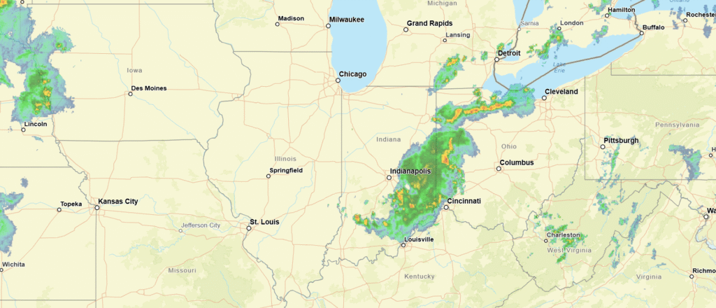
You can see a band of storms drifting into Ohio. Get used to looking at this, South Bend.
We took a look at Houston for our most recent forecast, which happened to present a forecast that fell over Memorial Day. We are approaching the summer season for the Gulf, which often means coastal showers and storms on most afternoons. I’m a proponent of including showers and storms in most forecasts down there, because that is often how it is going to turn out. Most everyone agreed with that line of thinking, but The Weather Channel boldly opted to leave precipitation out of the forecast. On this day, none of the rain hit the station at Houston, which turned a Victoria-Weather victory to a Weather Channel one. Actuals: May 24th, High 86, Low 68 May 25th, High 88, Low 73
12:17AM: Hello, Gen Z’ers and welcome to June 7th. Somewhat unusually, the main feature for the next several days will be a trough over western Canada. This is leading to severe weather in Montana and North Dakota tonight, and will keep the focus on that part of the world tomorrow as well, and then again by mid week.
11:31PM: This is getting fairly repetitive. Severe weather keeps churning in central South Dakota, and a bit of convection continues into southwest Minnesota, particularly around Montevideo and Willmar. It’s been doing this for a couple of days now! The pattern is changing for tomorrow and the weekend.
11:15PM: The somewhat tepid looking June is living up to the forecast we discussed yesterday. The SPC is looking at isolated severe weather in the Northern Plains for the next few days, but nothing like a major outbreak. The Southeast looks dry. Not much is changing, but there isn’t anything overwhelming ongoing either
7:47PM: There are severe storms in the Dakotas this evening, but a bunch of dry air ahead of them. Fire danger is high in the Northwoods of Minnesota and into Wisconsin. It sure would be nice for the weather to reach this area (the rain, not the severe stuff), but it is not to be.
11:51PM: As I noted earlier this week, El Nino should render the Atlantic hurricane season a bit milder. But it’s going to be busier in the Pacific, starting…. now.
June 1 is an inflection point on the meteorological calendar. It is the beginning of hurricane season, and the beginning of the meteorological summer season. Meteorological summer is marked by very warm temperatures in the south, along with dry conditions in the west and a steady diet of thunderstorms in the southeast. Also, the onus for severe weather shifts to the north. June itself is the most active severe period for the northern Plain and western Great Lakes.
How will this summer fit with the standard summer?
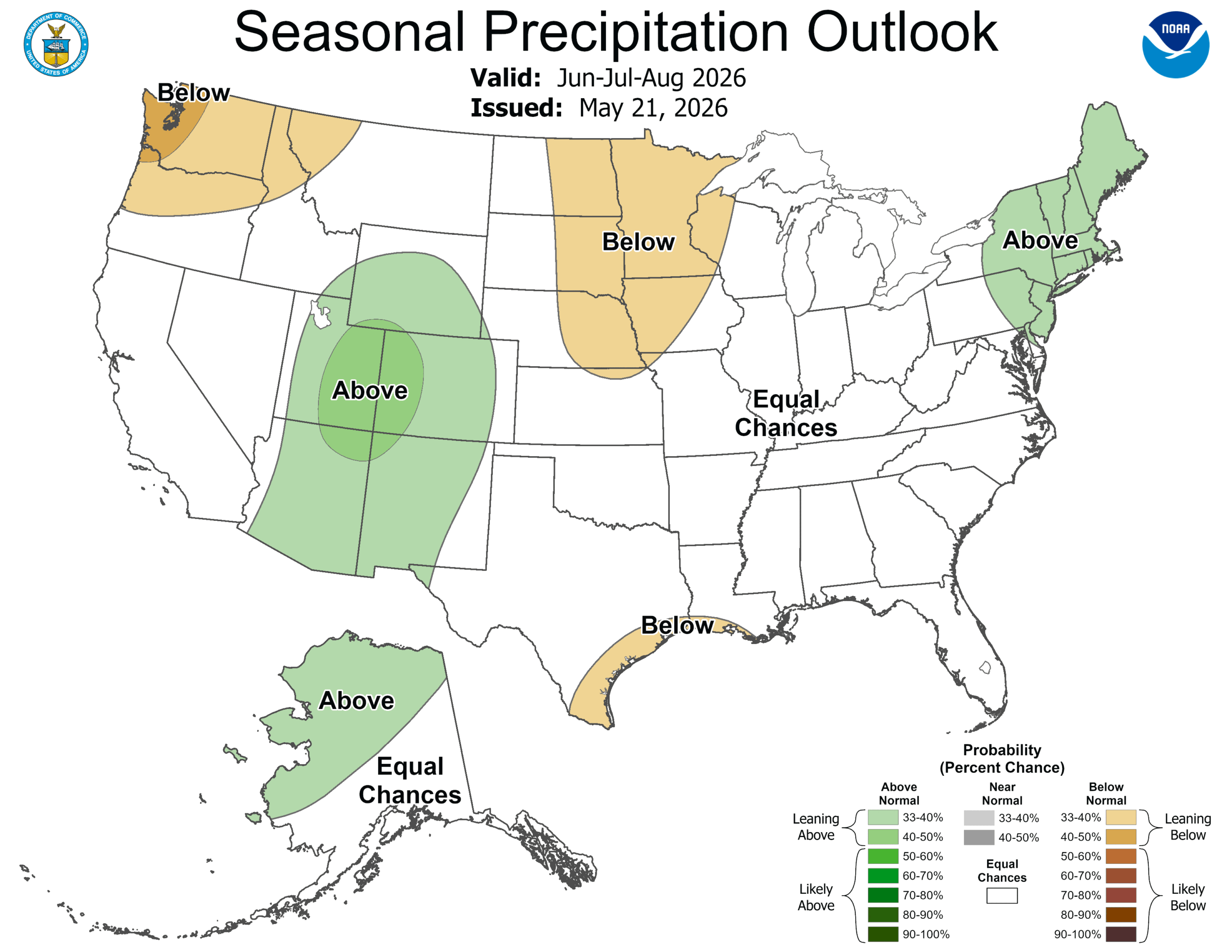
Precipitation has several areas that are expected to be outside of the normal ranges, but they are generally small, and could go either way. The only stand out is the Rockies, where it looks like the monsoon should be particularly active this summer.
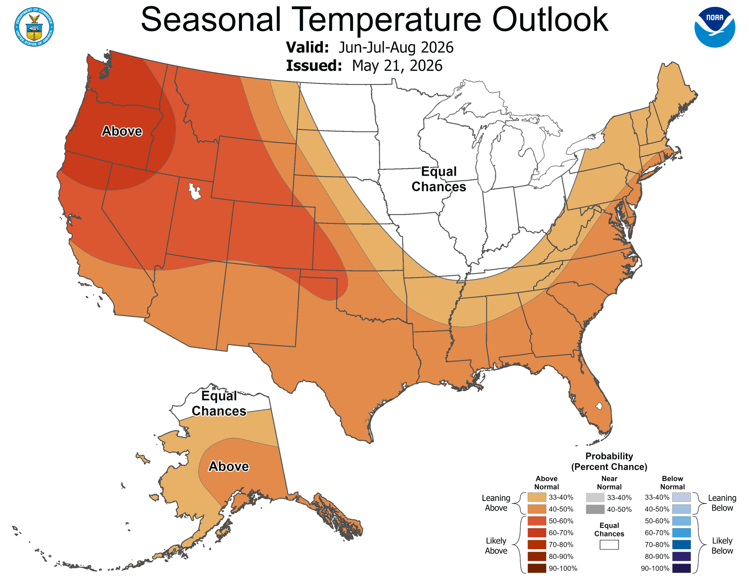
The temperatures offer a different tale. The west in particular will be warmer than normal, with the south also expected to be above normal. The hot get hotter.
Enjoy the heat, stay hydrated, and have a good summer.
9:01: Happy meteorological summer, everyone! 6/1 is the beginning of meteorological summer, and probably closer to the beginning of what the lay person calls summer. Astronomical summer, of course, begins on June 21st. That’s a sad day, though, as days start getting shorter then. Hooray daylight! Hooray Pennsylvania, without a cloud in the sky! Well, too late, I guess. It is 10 there now.