A regular reminder to follow the jet stream

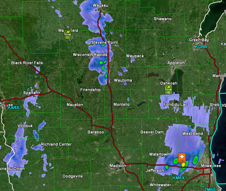
Two of the larger weather stories in the last several weeks have surrounded the flash flooding and heavy rainfall in southern California, and now, this week, even yesterday, is the snow falling in New York City and surrounding areas. These are two major media centers, so they get more coverage than the tornadoes in Wisconsin or the severe weather in the southeast of the last couple of days, but they share more in common than just their notoriety.

As I have noted in the past, the thing you have heard of as the “atmospheric river” is basically the conveyor of systems that follow the jet stream. The jet doesn’t typically dig far enough south to be directed at the LA Basin, but that’s exactly what happened earlier this month, when flooding rain came to the region.

Typically, high pressure is in control in the Pacific off the coast of Southern California, which deflects the jet as well as features that would follow the jet. When the jet sinks south and well formed features can move into the Los Angeles area, they interact with the rugged terrain, and flash flooding can arise very quickly, as it did this month.

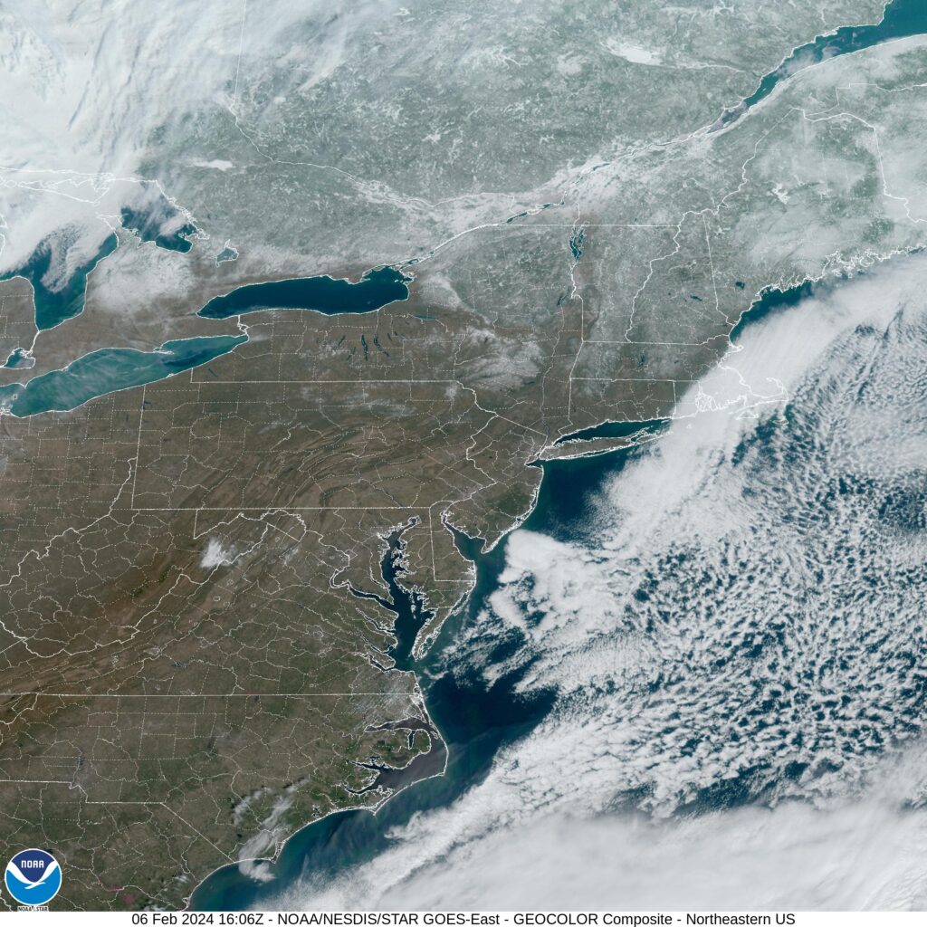
The jet actually sunk further south out west, but a southwest to northeast streak ran back north through Mexico, the Gulf and along the East Coast. The whole conveyor belt of energy is more familiar in this part of the world, but gave rise to the severe weather in the southern Plains over the weekend, and the snow that fell in the Mid-Atlantic yesterday.

We are used to systems following this jet streak pattern giving rise to nor’easters along the east coast. Because the area within the trough when the jet is angled at southern California is over the ocean, cold air doesn’t move in. On the East Coast, the trough is over the chillier continental US, which means snow on the north side of the jet streak. On this occasion, it was quite a bit of snow.

The jet responds to temperatures over land, but also currents and sea surface temperatures. This is the direct impact that El Nino and La Nina play on the weather over a season. It pays to pay attention when we are in one or the other, because of the role it plays in the jet stream course for a particular season. Knowing where the jet lies goes a long way to telling us what the pattern is going to be.

Dropping Off

Things sure can change in a week. We looked at Springfield, Massachusetts about this time last week, and it was ensconced in high pressure. This led to a pretty quiet forecast with a broad range of temperatures. Today, weather has rolled in, and many parts of New England and the Mid-Atlantic are seeing significant snowfall, and in some placed, seeing it for the first time in a while. The biggest hang up in the forecast was that dynamic change in temperatures, especially at night. Clouds never really played a factor, and the morning low on both Wednesday and Thursday fell below expectations. Clime had a good day, however, and was rewarded with the top forecast for the day.
Actuals: Wednesday – High 44, Low 19
Thursday – High 50, Low 22

Grade: C-D

Video: February Tornado drops near Madison, Wisconsin

Check out the above video from the Milwaukee Journal-Sentinel. A tightly wound area of low pressure, remnant from the activity seen in southern California earlier in the week, swept through the Western Great Lakes yesterday, feasting on very warm temperatures to trigger severe storms from Dubuque, Iowa to Lake Michigan.

The tornado did cause some damage in the Wisconsin town of Evansville, which is south of Madison. The twister will likely be rated as an EF2, based on some estimates I’ve seen, which is quite strong for an offseason storm. The damage around Evansville was enough that US-14 was closed until midday today.

The system also provided very gusty wind in the wake of it’s passage, reminiscent of some early autumn systems in this part of the country. Snow is falling in northern Minnesota, Wisconsin and the Upper Peninsula of Michigan today thanks to the cold air funneled in. The intensity of this clash of air masses is atypical in what should be the dead of winter, and was clearly enough to produce this tornado.

The rest of the month of February looks just as unrelenting as the first week. Temperatures will be below normal for a lot of country, especially east of the Rockies. Meanwhile, more moisture is coming for the west coast. There will naturally be immediate consequences out west, where more moisture is not needed, but also, the change in pattern indicates a pretty wild shift to get there.

Wind, hail blowing through Wisconsin

A tightly wound area of low pressure, remnant from the terrible flooding in the Southwest, is plowing through the Great Lakes. It’s February 8th, and the feature is intense enough that it is producing storm reports, including 50mph wind and 1 inch hail.

I should note that these are simply the most recent observations, with the wind coming from the system in the area, but there was even a tornado observed south of Madison this afternoon. It was the first February tornado in Wisconsin in recorded history.

Springfield, Massachusetts

I am sure this is something you all know out in New England, but I learned recently that Springfield is actually serviced by Hartford’s Bradley International Airport. They are so close!

At 1055AM, ET, Springfield was reporting clear skies with a temperature of 31. There is a steady north wind thanks to a vast gyre off the coast of New England, and some scattered clouds north of Massachusetts, but despite these factors working against the town, a pleasant February day is anticipated.
Surface high pressure will continue to remain in place for the next few days, but a jet ridge will start nosing into the area by the end of the week, with a warm front nosing in on Thursday, really bringing about a warming trend.
Tomorrow – Mostly sunny, High 43, Low 26
Thursday – Partly cloudy, a bit warmer, High 47, low 28

TWC: Tomorrow – Generally sunny despite a few afternoon clouds. High 44, Low 25
Thursday – Plentiful sunshine. High 47, Low 26

AW: Tomorrow – Plenty of sun High 46, Low 24
Thursday – Sunny and mild High 48, Low 25

NWS: Tomorrow Sunny, High 43, Low 24
Thursday – Sunny, High 46, Low 25

WB: Tomorrow – Sunny, High 40, Low 28
Thursday – Sunny, High 45, Low 28

WN: Tomorrow – Mostly sunny, High 43, Low 24
Thursday – Mostly sunny, High 46, low 25

CLI: Tomorrow – Partly cloudy, High 46, Low 25
Thursday – Sunny, High 50, Low 25

Wow, Clime is going for the gusto, boldly putting Springfield at 50. We’ll see how that goes.

The atmospheric stream

The “atmospheric river’ terminology is one that has really captured the imagination of the media, and we are hearing it quite a bit right now as rainfall is inundating southern California. The atmospheric river is simply a strong active jet stream, and when it comes from the sea, there is more moisture available, and “more moisture” isn’t something we think of when talking about southern California. In fact, last month when we were forecasting for San Luis Obispo, I thought the few showers showing up in the area were remarkable enough to call them out ostentatiously. The rain seen now in the LA Basin is several orders of magnitude larger than that, so if this is the atmospheric river, then what we saw in late January was a mere stream. A trickle. For the day, WeatherNation had the forecast victory, being the best temperature forecaster among outlets that left rain in the forecast on the 25th.
Actuals: January 25th, .01 inches of rain, High 66, Low 51
January 26th, High 75, Low 48

Grade: B-C

January Forecaster of the Month

We were pretty insistent on churning out forecasts to start the year, which was good, because the weather was just as active as our forecast schedule. Given the frequency of our forecasting, and the intensity of the weather this month, it was a well earned victory for our winning forecaster, The Weather Channel

OutletForecast Wins (year)
The Weather Channel2.83
Victoria-Weather1
Accuweather0.83
National Weather Service0.83
WeatherNation0.5
Clime
Weatherbug

The work week is right around the corner, and it looks terribly active, especially out west, where flooding and mountain snow are going to be the story for millions of people in California and Nevada. Fortunately, this won’t translate to severe weather later in the week. I’ll look forward to having a few posts on all this weather, including forecasts, starting as soon as tomorrow.