The beginning and middle of the month of December were rough, to say the least. The second major system featuring severe weather started in the northern Plains, and reached the Great Lakes by our December 16th forecast time in Grand Rapids. There was a gust of nearly 60mph, even outside any precipitation on Thursday the 16th. Temperatures, which started in the low 60s on Thursday were ready for a decline, dropping 35 degrees for Friday. Even though the weather was bad, forecasts were generally good. The Weather Channel had the best temperature forecast, but Forecast.io drew level as they were one of only two not to have rain in the forecast. Actuals, Wednesday December 16th, High 63, Low 35 Thursday, December 17th, High 38, Low 28
The holidays are upon us and travel is going to be much more common this year than it was last year. How will it be, going from one place to another tomorrow, especially along the 712 mile stretch between Lynchburg and Grand Rapids. We’re going to cover it all in one day, at a pace of 63.2mph. It is going to be a long drive, so make sure you hit the restroom before we hit the road.
Lynchburg, Virginia
The next system is getting ready to develop in the Ohio Valley, and it’s sure nice to not have to describe it in apocalyptic terms. Still, for a road trip through the region, it’s still going to introduce challenges to our itinerary. The warm front associated with this system will have lifted north of Lynchburg and most of Virginia by the time we set forth on Saturday, but the warm southerly flow will potentially lead to a stray spot of drizzle, and the associated moisture may lead to some fog in the mountains of West Virginia. The reain will begin in earnest after we hit about Athens, Ohio, and will continue across the Buckeye State. It will be overcast when we reach Michigan, but the precipitation will be moving out of the state. Expect some wet flakes to mix in with the rain, maybe as early as Toledo, but the precipitation will wind down around Battle Creek. Given the wind dynamics, chill to the air and the presence of a Great Lake to the west, there could be a fewbands of lake effect snow in western Michigan, of which, one may linger in Grand Rapids for our arrival.
Grand Rapids, Michigan By Rachel Kramer – https://www.flickr.com/photos/rkramer62/3965913452/, CC BY 2.0, https://commons.wikimedia.org/w/index.php?curid=108742650
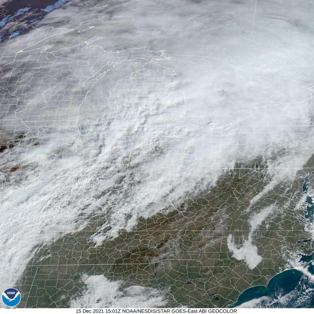
A large nasty area of low pressure is threatening to create another significant December severe weather outbreak, this time in Minnesota and Iowa. How well will the nasty weather hold together? Does Michigan need to brace itself
At 953AM, ET, Grand Rapids was reporting overcast skies and a temperature of 50 degrees. Low pressure in the Plains was already working to pump warm air into the Great Lakes, leading to near record highs at this early hour. Snow melt was putting a lot of extra moisture in the air and leading to extra fog and clouds across the region. Eventually, there may be some clearing later today, but not much, even with aggressive southerly flow. The rapidly developing, strong system in the Plains is also going to be very fast moving, with the associated cold front arriving in Michigan early tomorrow morning. Fortunately by that point, the dynamics of severe weather will be gone, and even the associated moisture will be drawn north to the center of low pressure. and little to no precipitation will accompany frontal passage. More typical December weather will follow on Thursday afternoon and into Friday, with clearer, colder but less breezy conditions. Tomorrow – Early drizzle and wind, then clearing and colder, High 57, Low 32 Friday – Mostly cloudy, High 36, Low 26
TWC: Tomorrow – Windy with a few clouds from time to time. (early rain) HIgh 60, Low 35 Friday, Partly cloudy skies. High 38, Low 28
AW: Tomorrow – Mostly cloudy and windy (early rain) High 59, Low 34 Friday – Sun and areas of high clouds in the morning; mostly cloudy in the afternoon High 40, Low 28
NWS: Tomorrow – Mostly sunny (Early rain) High 58, Low 36 Friday – A slight chance of rain and snow showers before 2pm, then a slight chance of rain showers between 2pm and 5pm, then a slight chance of rain and snow showers after 5pm. Partly sunny, High 40, Low 29
WB: Tomorrow – Windy, Mostly sunny, High 61, Low 34 Friday – Mostly sunny until midday, then partly sunny with a 20 percent chance of rain and snow showers, High 35, Low 30
WN: Tomorrow – Partly cloudy with light rain showers, High 59, Low 43 Friday – Partly cloudy, High 39, Low 29
FIO: Tomorrow – Dangerously windy until afternoon. High 60, Low 34 Friday – Partly cloudy throughout the day. High 39, Low 28
The map is very cloudy this morning, and may be for the entire day. Fortunately for Grand Rapids, it looks like they are going to duck the worst of the weather, and will instead jump right back to December.
The forecast didn’t waiver by a lot in Grand Rapids, but there was one element that separated a couple of outlets. Just north of a system that would dump snow measured in feet on the mid-Atlantic, west winds off Lake Michigan brought a few snow showers to Grand Rapids on Wednesday, which elevated the results for only two outlets: Accuweather, and the winner of the day, Victoria-Weather. For results to fluctuate much on a precipitation error, the temperatures had to have been fairly close, which they were. The Weather Channel was good on temperatures, but off on the snow, which set them back, like nearly everyone else. Actuals: Tuesday – High 29, Low 19 Wednesday – Trace of snow, High 30, Low 23
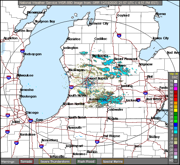
Welcome back to Victoria-Weather’s forecasting adventure zone. Grand Rapids is down wind of Lake Michigan, with fairly strong gusts being noted. Not to give anything away about the precipitation or anything.
At 453PM, ET, Grand Rapids was reporting temperature of 28 degrees with mostly cloudy skies. There have been a few streaks of light snow across western Michigan today, provided by winds off the Lake of up to 30mph. This is certainly a microscale event, as more generally, high pressure dominates the region. A shortwaved ridge over the Ohio Valley and Great Lakes is contributing to the high pressure focused over the Upper Midwest and spreading into the Great Lakes. A deep, broad jet trough will overtake the middle of the country and birth an area of low pressure over the northern Gulf of Mexico, which will translate swiftly to central Appalachia. The existing surface ridge will squash the system to the south and east, away from Lower Michigan, but the induced northwest flow will mean a chance for some flakes, particularly on Wednesday, as well as dropping temperatures later in the week. Tomorrow -Mostly cloudy, High 33, Low 21 Wednesday – Isolated flurries with mostly cloudy skies, High 30, Low 21
TWC: Tomorrow – Mostly cloudy. High 30, Low 22 Wednesday – Overcast High 33, Low 24
AW: Tomorrow – Sun through high clouds High 32, Low 18 Wednesday – A couple of snow showers in the morning; otherwise, mostly cloudy High 35, Low 20
NWS: Tomorrow – Partly sunny, High 29, Low 19 Wednesday – Cloudy High 33, Low 24
WB: Tomorrow – Partly sunny, High 29, Low 22 Wednesday – Mostly cloudy, High 31,Low 24
WN: Tomorrow – Partly cloudy, High 29, Low 19 Wednesday – Mostly cloudy, High 33, Low 24
FIO: Tomorrow – Mostly cloudy throughout the day. High 31, Low 24 Wednesday – Overcast throughout the day. High 33, Low 26
Well, it’s going to come down to cloud cover, but it’s interesting that we are moving in different directions on those highs, right? Here are a few bands of lake effect snow in western Michigan