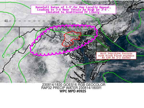
There is a stretch of of the US, generally from the Chesapeake southeast through the central Appalachians, which remains under a slight risk for today. That area will shift only a bit to the southeast tomorrow, and will bring some steady rain along the way. Already, parts of Maryland are being monitored for flash flooding.
The mid-Atlantic has seen a little bit of rough weather of late, and it’s mounting. Heavy downpours are a bit more apt to cause flooding, and that appears to be the situation tonight.
I’m going to be verifying the forecast for Orlando later today, and while I know that the weather today is similar to what it was when we issued the forecast earlier this week, there is another similarity that is ongoing. It’s the middle of August, but we aren’t looking at any imminent tropical features in the North Atlantic.
With the forecast for hurricanes continuing to be above average, this could certainly change on a dime. The hurricane driven winds that exacerbated the wildfires in Maui, are a reminder that the North Atlantic is not the only place threatened by tropical storms.
Oh, good evening, large thunderstorm cluster bearing down on Philadelphia. Expect some hail out of this guy and some briefly gusty winds. There were some trees down southwest of Reading thanks to this one. Even if this doesn’t bring the severity into Philadelphia, it is still arriving in the wee hours of the morning when you should be sleeping. A rough morning awaits.
A large tornado watch continues for the eastern Great Lakes, including a couple of active tornado warnings in northeast Ohio. The watch extends into western New York, but at this time, there are no warnings there. Don’t get complacent yet, there is still an enhanced risk for the region.
It’s been since the spring, but the SPC has actually started using the Days 4-8 outlook imagery, at least days 4-5, with a mass of potential storms moving through the Ohio Valley to the mid-Atlantic. For now, it is something of a curiosity, but with this much certainty this far out, it seems fairly likely that the outlooks will be upgraded as we get closest to Sunday and Monday.
The National Weather Service in Omaha is looking ahead to some severe weather in the northern part of the region tomorrow, between 6pm and 1am. I know this because I looked at this graphic for about half a second, and realized that I should share it as an example of meteorologists getting to the point and getting the message across.
Norway is a very important country in the history of meteorological research. Vilhelm Bjerknes formed the Bergen School of meteorology, which produced meteorologists like his son Jakob and Carl Rossby, as well as the Norwegian Cyclone model, which is one of the first basic understandings of how low pressure systems work, with warm and cold fronts, which reach occlusion and deteriorate. For all that meteorological history and prowess, the country is sure upside down today.
Via Accuweather
I highlighted a few places, namely the two warm spots and the coolest spot. Tromso and Bodo are both north of the Arctic Circle. Drammen is in the southern part of Norway, southwest of Oslo. (Bergen, the city of meteorological record, is also chilly and in the southern part of the country.) The cities are the same distance apart as New York and Orlando, so this is particularly unusual. When you look at the radar and see most of the North Sea socked in with rain, it starts to make more sense, and when you realize the Arctic is still seeing full daylight for 20 hours a day, it all clicks.
Today is setting up to be an adventurous weather day. As you can see by the graphic on the upper right corner of the page, the SPC has a moderate risk for severe weather in the Appalachians and mid-Atlantic, with a tornado watch already set up for the western face of the range, including much of the upper Ohio Valley. Storms there are just emerging, with the first severe warnings near Parkersburg, West Virginia, and more certainly to follow.
An existing line of thunderstorms is also racing eastward, east of Memphis, and has a history of producing 65mph winds.
If all that wasn’t enough, the SPC also has a mesoscale discussion out for eastern Washington and northern Idaho. I can’t imagine we will remember the weather there like we may remember the weather furth east as the day goes on.
This is a bit of a long range out look, and it is pretty specific to the northeastern corner of the country. It’s pretty warm in New England, down through the Mid-Atlantic, and with a stalled trough over the Great Lakes, that warmth is going to continue building up into the northeastern US for several more days. According to the long term outlooks for the rest of the month, however, things will be about normal as far south as DC. Fingers crossed that means a pretty cool end of the month?
I certainly thought that today, at the very least, would be the last day for showers and storms in the mid-Atlantic. If I am being fully honest, I will admit that I kind of thought yesterday would be that day. Instead, there is just the barest threat for showers and storms even tomorrow.
EDIT: I guess I will note that the precipitation threat is gone tomorrow between Cumberland and Louisville. I was close, just used the wrong forecast.