We all know about the urban heat island. Typically, city center or airport observation points are the warmest local point in an area. Not Cincinnati! The airport in Covington (KCVG) is the low point around southeast Ohio.

from Victoria-Weather

We all know about the urban heat island. Typically, city center or airport observation points are the warmest local point in an area. Not Cincinnati! The airport in Covington (KCVG) is the low point around southeast Ohio.
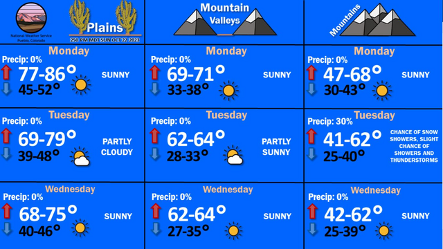
NWS Pueblo just posted this graphic. I think we all know that the Plains are warmer than the mountains, but I think the real intrigue is how close valley temperatures are to the mountains.
Back when I forecast for Victoria, the forecast took into account Hurricane Norma, which was scheduled to attempt to traverse northern Mexico. Well, it’s Sunday, and Norma is still just hanging out. We’ll see what happens with that verification, what with our no show.
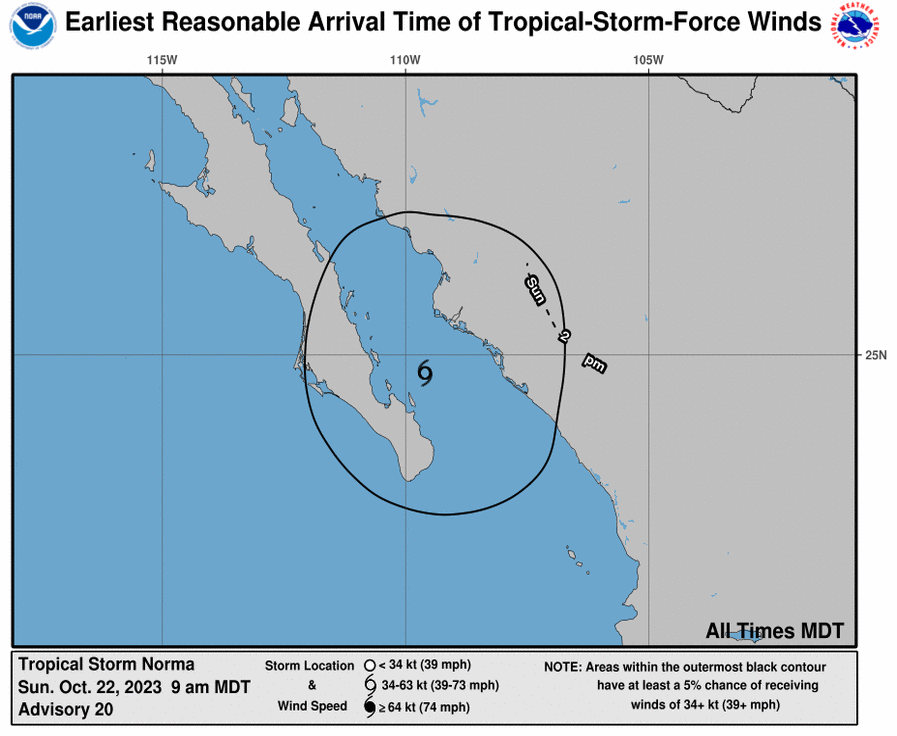
The latest guidance has Norma taking a more northerly tract. It looks rainier than it did when we looked at the beginning of the weekend, but will never really reach east Texas. Instead, look for Norma to bring some heavy rain to west Texas after arriving from the southwest. You know, like tropical features do so often.
During the most recent forecast, I mentioned a couple of features headed for the headlines this week. First, a system moving through the northern Plains, which incidentally may bring about enough cold air to bring snow as far east as the Nebraska Panhandle. Second is the remnants of Tropical Storm Lidia, and we all know how soggy tropical features can be. That northern feature might even have more rain, at least over the US.
UPDATE: Great news! The threat for snow is looking less than we expected earlier. Still going to be plenty up in the mountains.

It hasn’t been nearly as cloudy as some had in the forecast for Bowling Green. Only the big airports are reporting clouds, and only because their vertical observations get higher. It’s still quite clear that all the warm air is in the Plains. It’s only in the 60s.
It’s a little too soggy this weekend in New England, what with Philippe and existing rain showers in the area, but the cold, dry air behind the system that Philippe is merging into is going to be perfect for accelerating the change in colors. If you get some clear air, it will be perfect for leaf peeping.

This image is from the NWS office in Hanford, in the central Valley of California. You thought we only gave percent chances for rainfall, huh? It’s pretty dry in California, so I guess meteorologists there just need to make use of the Stats classes we all took in college.

We made it through the most stressful month of hurricane season, and are moving into at a breakneck pace towards winter. I think autumn and the beginning part to winter are the hardest seasons to forecast for. Those first snow storms are impossible to get right. Wish us all luck
It’s one last blast of summer for the Central Plains, with record heat cancelling the Twin Cities Marathon yesterday, hours before it was scheduled to start. This incredible warmth is only hear for a little bit longer though. By the end of the week, places like Great Falls and Bismarck are going to be playing footsie with the freezing line in the mornings.