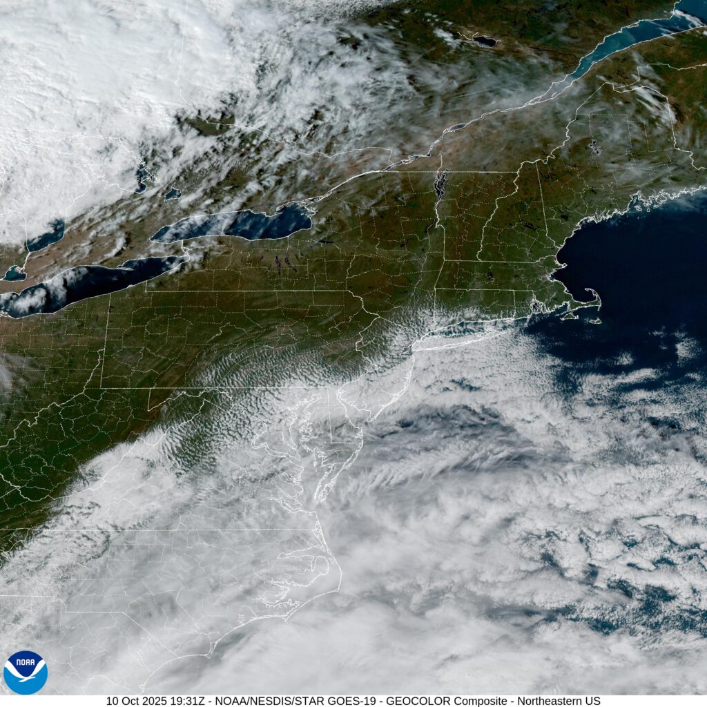
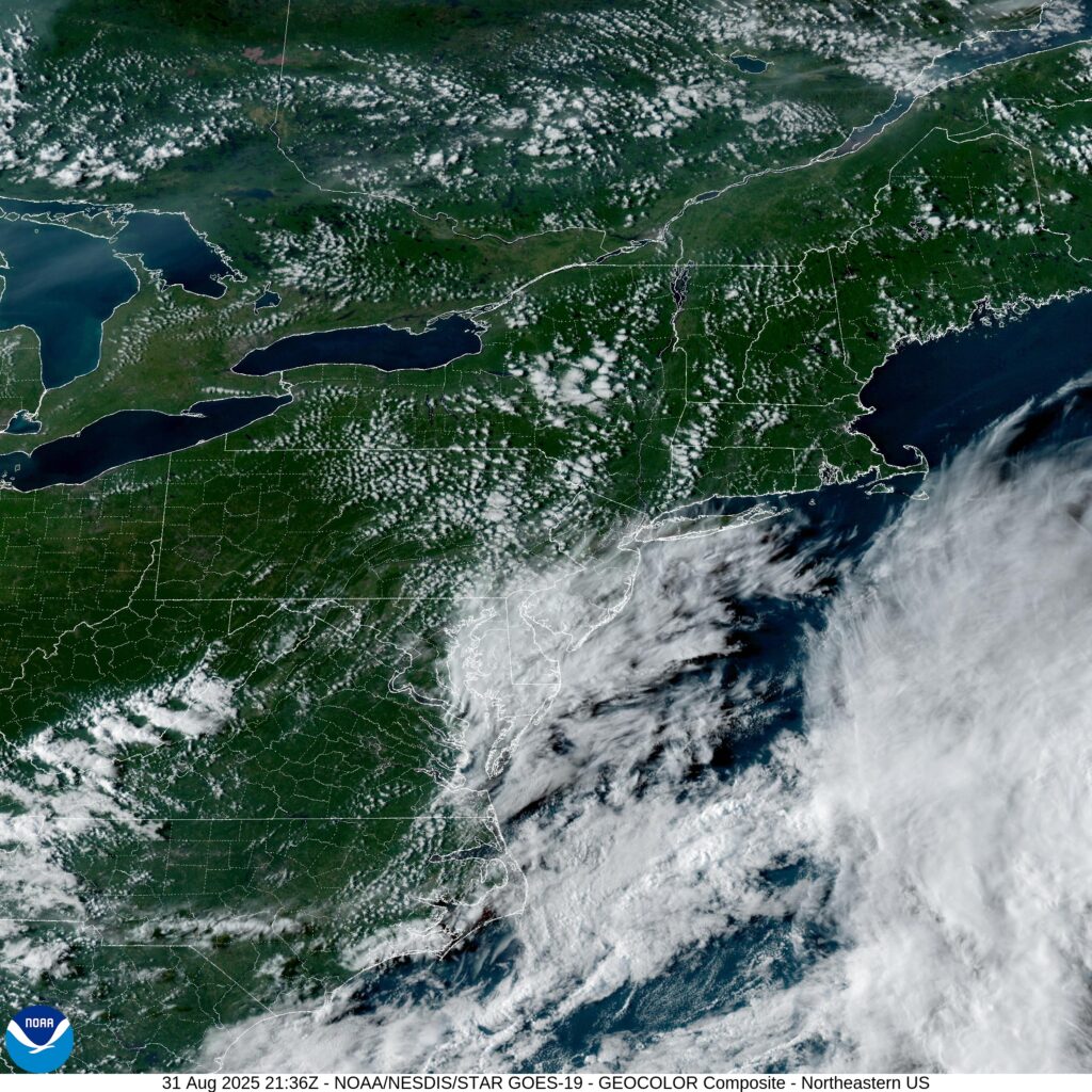
Fort Collins, Colorado

Having some minor (I hope) server issues today at Victoria-Weather HQ. That shouldn’t change the weather in Fort Collins, though, right? What can we expect in Northern Colorado this weekend?

At 956AM, MT, Fort Collins was reporting a temperature of 77 degrees with clear skies and a brisk north wind. There is a bit of shower activity across northern Colorado is associated with a cold front appended to an area of low pressure in western Ontario. A leading trough has switched winds to northerly across Fort Collins, but the boundary remained just to the north in southern Wyoming. Shower activity is largely found in the mountains west of Fort Collins and Cheyenne, though there will be some light activity as the day wears on, lasting into the morning tomorrow.
As the area of low pressure moves on to the east, high pressure will build in the Plains. In the southwest, warm air will begin to build again, and a laminar flow over the Rockies will lead to a down-slope and lee troughing in the Colorado flatlands. The contrast in air mass will lead to some ridge-riding thunderstorms in eastern Colorado by Sunday, but guidance and intuition suggest that the bulk of the activity will be south of the Palmer Divide, leaving Fort Collins mostly unbothered, but late in the period some activity could press into the area.
Tomorrow – Isolated showers, especially early, High 74, Low 60
Sunday – Partly to mostly cloudy, isolated thunder late High 80, Low 57

TWC: Tomorrow – Scattered thunderstorms in the morning. Partly cloudy skies late High 78, Low 61
Sunday – Partial cloudiness early, with scattered showers and thunderstorms in the afternoon High 75, low 51

AW: Tomorrow – Low clouds breaking for some sun with a thunderstorm in one or two spots High 76, Low 60
Sunday – Intervals of clouds and sunshine with a thunderstorm or two in the afternoon High 76, Low 55

NWS: Tomorrow – A chance of showers, with thunderstorms also possible after noon. Mostly cloudy, High 75, low 59
Sunday – Showers likely and possibly a thunderstorm between noon and 3pm, then showers and thunderstorms likely after 3pm. Partly sunny, High 79, low 58

WB: Tomorrow – Mostly cloudy. Chance of showers in the morning then a chance of thunderstorms in the afternoon High 72, Low 60
Sunday – Thunderstorms likely. High 74, low 56

WN: Tomorrow – Mostly cloudy with scattered showers and a chance of storms, High 75, low 59
Sunday – Mostly cloudy with light showers and scattered storms, High 79, Low 58

CLI: Tomorrow – Thunderstorm, High 76, Low 60
Sunday – Thunderstorm, high 78, low 56

Count me in the “not likely” camp on Sunday thunderstorms. Everything right now just looks like it will show up too far to the south. Not today though, here is radar imagery, with showers heading in from Wyoming.

Midland, Texas

Midland, despite it’s name, is not really in the middle of anything, except, perhaps “nowhere”. Fairly isolated in west Texas, save for a proximity to Odessa. Let’s see if they can look forward to anything more than dust.

At 353PM, CT, Midland was reporting a temperature of 96 degrees with fair skies. Midland was northwest of the dry line, with a dew point in the upper 50s, compared to the dew point in Brownwood and Stephenville, which sat in the 70s. A local eddy was still producing some showers behind the primary dry line, notably over the southeastern corner of New Mexico.
The trough related showers and storms over the High Plains will become less active as a storm system in the Canadian Prairie moves towards the northern Great Lakes. Onshore flow from the Gulf will still be present, and showers will be likely over south Texas, but the end of the work week should be dry in Midland.
Tomorrow – Mostly sunny, High 100, Low 74
Friday – Mostly sunny, High 99, Low 75

TWC: Tomorrow – Partly cloudy, High 100, Low 74
Friday – Intervals of clouds and sunshine, High 97, Low 76

AW: Tomorrow – Breezy in the morning; otherwise, hot with sunshine mixing with some clouds; High 100, Low 75
Friday – Breezy and very warm with periods of clouds and sunshine High 99, Low 77

NWS: Tomorrow – Sunny, High 98, Low 74
Friday – Sunny, High 97, Low 76

WB: Tomorrow – Sunny, High 97, Low 76
Friday – Sunny, High 94, Low 77

WN: Tomorrow – Mostly sunny, High 98, Low 74
Friday – Mostly sunny, High 97, Low 76

CLI: Tomorrow – Sunny, High 98, Low 74
Friday – Partly cloudy, High 97, Low 75

Those showers in New Mexico dissipated before I took the image of the satellite. But storms in Texas are still roaring tonight, not threatening Midland at all.

Pine Bluff, Arkansas

Our forecast today is taking us to central Arkansas. It’s not quite the Ozarks, not quite the Mississippi Valley, it’s Pine Bluff!

At 753PM, CT, Pine Bluff was reporting a temperature of 84 degrees, with dew points in the low 70s. The high dew points were not enough to trigger isolated thunderstorms across the region, with a weak upper ridge nosing into the region, suppressing flow in any direction.
Guidance is fairly consistent about lee troughing emerging as the week draws to an end. If anything, this will mean even more humidity, this time from the Gulf, rather than augmented by the woods of the Ozarks, and at all levels. While precipitation isn’t expected, there is an increased level of clouds by Friday.
Tomorrow – Mostly sunny, high 91, Low 70
Friday – Partly cloudy, High 96, Low 71

TWC: Tomorrow – Sunshine. High 97, Low 71
Friday – Sunshine. High 98, Low 73

AW: Tomorrow – Mostly sunny High 96, Low 70
Friday – Plenty of sunshine High 96. Los 71

NWS: Tomorrow – Sunny, High 96, Low 71
Friday – Sunny and hot,  High 97, Low 71

WB: Tomorrow – Sunny. High 94, Low 75
Friday – Sunny. High 92, Low 73

WN: Tomorrow – Mostly sunny, High 96, Low 71
Friday – Mostly sunny, High 97, Low 71

CLI: Tomorrow – Sunny, High 96, Low 71
Friday – Sunny, High 98, Low 72

It looks fairly quiet on radar over Arkansas. Those storms aren’t going to be working north any time soon.

San Luis Obispo, California

We are on our way to Point Conception, north of LA for this forecast. There were tsunami advisories south of SLO today, which is not something I have seen on an NWS alert map in the past.

At 656PM, PT, San Luis Obispo was reporting clear skies and a temperature of 64 degrees. There was a brisk onshore flow, keeping things comfortable west of the Coastal Range, though it was in the mid-90s on the other side of the mountains.
There is a jet streak over central California ensuring onshore flow will be maintained with some vigor, however of greater note is the low clouds lurking offshore. Point Conception is prime territory for morning low clouds and fog, and each of the next to days should feel the impact of the Marine Layer.
Tomorrow – morning clouds and fog, High 76, Low 55
Friday – Morning clouds, clearing, High 76, Low 55

TWC: Tomorrow – Partly cloudy skies High 74, Low 54
Friday – Sunshine along with some cloudy intervals. High 75, Low 56

AW: Tomorrow – Clouds giving way to sun High 77, Low 56
Friday – Mostly sunny and nice High 78, Lo 56

NWS: Tomorrow – Patchy fog before 11am. Otherwise, cloudy through mid morning, then gradual clearing,  High 75, Low 55
Friday – Patchy fog before 11am. Otherwise, cloudy through mid morning, then gradual clearing High 76, Low 55

WB: Tomorrow – Low clouds and fog in the morning then sunny. High 81, Low 58
Friday – Low clouds and fog in the morning then sunny. High 80, Low 59

WN: Tomorrow – Partly cloudy, High 75, Low 55
Friday – Partly Cloudy, High 76, Low 55

CLI: Tomorrow – Sunny, High 74, Low 56
Friday – Sunny, High 74, Low 58

Wow, one degree different from the NWS forecast. We’ll all feel pretty silly if we are a ways off. Satellite shows the lingering clouds offshore.

Danville, Illinois

Danville lies along the Indiana border, south of Chicago, and deep inside of corn sweat country. Are you ready to swelter?

At 355PM, CT, Danville was reporting a temperature of 91 degrees with clear skies. Importantly, dewpoints were in the low to mid 70s across the regions, making things even more uncomfortable. Lower level forcing is driving a bit of surface development, which is initiating in the High Plains. The moisture that crops up here will then track along the southern edge of a ridge that has emerged over the north central part of the US. There is, as a result, a marginal risk of severe weather for the area tomorrow. There is weak forcing but unstable air. Things may unfold quickly.
If things proceed as current longer range models indicate, storms will arrive in Danville and linger into the overnight hours, before exiting town in the predawn of Thursday. If this is another derecho, as have been frequent of late, don’t be surprised if the onset is earlier than currently indicated. Fortunately, the ridge is going to continue to squash further south. It isn’t necessarily enjoying the benefit of cold air, but the air is dryer, and Thursday afternoon, at the very least, will be pleasant.
Tomorrow – Rain in the afternoon, with strong thunderstorms possible overnight, High 92, Low 72
Thursday – Early morning thunderstorms, with gusty winds, then much more pleasant, High 79, Low 66

TWC: Tomorrow – A mix of clouds and sun early, then becoming cloudy later in the day. A stray thunderstorm is possible High 91, Low 70
Thursday – Scattered thunderstorms in the morning, then cloudy skies late.  High 75, Low 66

AW: Tomorrow – Warm and humid with variable cloudiness; a couple of heavy thunderstorms in the afternoon; storms can bring flash flooding and damaging winds High 89, Low 70
Thursday – Periods of rain and a thunderstorm in the morning; mostly cloudy and humid; heavy downpours can reduce visibility and cause ponding on streets and highways High 74, Low 68

NWS: Tomorrow – 40 percent chance of showers and thunderstorms after 1pm. High 89, Low 72
Thursday – A 50 percent chance of showers and thunderstorms before 1pm. High 77, Low 65

WB: Tomorrow – Patchy fog in the morning. Sunny with a slight chance of showers and thunderstorms in the morning then partly sunny with a chance of showers and thunderstorms in the afternoon. High 93, Low 74
Thursday – Mostly cloudy. A chance of showers and thunderstorms in the morning. High 76, Low 66

WN: Tomorrow – Partly cloudy with a chance of storms, High 89, Low 72
Thursday – Mostly cloudy with a chance of storms, High 78, Low 65

CLI: Tomorrow – Thunderstorm, High 91, Low 71
Thursday – Thunderstorm, High 76, Low 63

Clearly, whatever happens in Danville this week is going to have a real impact. Expect better sleeping this later this week, central Illinois. Satellite with a few clouds by St. Louis before the sun goes down.

Phoenix, Arizona

We aren’t yet to the peak of monsoon season in the southwest, but it is certainly summer. I expect some good numbers for our forecast outlets, and a toasty temperature read out.

At 1051AM, ET, Phoenix was already reporting a temperature of 98 degrees with clear skies. It would be a hot day again today. While the monsoon season hasn’t gotten fully cranked up, there are afternoon showers and storms erupting along the New Mexico border, with a threat for afternoon activity generally north of Tucson.
The synoptic pattern is non existent, which means a persistence forecast is in order. Even if a stray storm wanders into Phoenix, the activity will erupt after peak heating has been achieved, so there won’t be much modification from being the model guidance.
Tomorrow – Mostly sunny, High 111, Low 88
Tuesday – Hot, sunny, High 110, Low 85

TWC: Tomorrow – Mainly sunny. High 109, Low 88
Tuesday – Mostly sunny skies. High 107, Low 88

AW: Tomorrow – Hot with hazy sun; wildfire smoke will cause the sky to be hazy High 112, Low 89
Tuesday – Mostly sunny and very warm; wildfire smoke will cause the sky to be hazy High 109, Low 89

NWS: Tomorrow – Sunny, High 109, Low 88
Tuesday – Sunny, High 108, Low 87

WB: Tomorrow – Sunny and hot High 109, Low 87
Tuesday – Mostly sunny. High 109, Low 92

WN: Tomorrow – Mostly sunny, High 109, Low 88
Tuesday – Partly cloudy with isolated storms, High 108, Low 87

CLI: Tomorrow – Sunny, High 109, Low 88
Tuesday – Sunny, High 108, Low 88

I told you that it is monsoon season, but there isn’t anything to show for it on satellite.

Fort Smith, Arkansas

It’s a hot on this holiday weekend, with a few scattered showers and storms across the middle of the country. It’s hard to produce a forecast for anywhere right now without giving a thought to the devastating floods in Kerrville, Texas over the weekend. My heart aches for all the families that have lost in Texas. It’s another reminder that, while the strength of a storm is always a factor, often just as impactful is the time and the place the storm occurs. Donate here.

At 753PM, Fort Smith was reporting a temperature of 91 degrees with clear skies. A trough moving through the middle of the country is triggering a band of thunderstorms through southern Missouri, but the southward progression of the system was not expected to bring that activity as far south as Fort Smith this evening.
Tomorrow afternoon, the heat and humidity of the region will provide enough instability for some showers and storms in the afternoon. A ripple in the lower levels of the atmosphere along the US-Canadian border will touch off a new band of showers and thunderstorms in the plains. This more organized band of storms will be a threat for Fort Smith on Tuesday evening, but not before another hot humid day transpires.
Tomorrow – Mostly cloudy, with showers and storms in the evening High 92, Low 72
Tuesday – Scattered clouds with some increasing showers and storm, High 90, Low 73

TWC: Tomorrow – Except for a few afternoon clouds, mainly sunny. A stray shower or thunderstorm is possible. High 92, Low 73
Tuesday – Mostly cloudy with scattered thunderstorms mainly in the morning High 87, Low 73

AW: Tomorrow – Humid with variable cloudiness; a thunderstorm in spots in the afternoon High 91, Low 75
Tuesday – Mostly cloudy and humid with a thunderstorm in parts of the area High 90, Low 74

NWS: Tomorrow – A slight chance of showers, then a chance of showers and thunderstorms after 10am. Mostly sunny, High 93, Low 75
Tuesday – Showers and thunderstorms likely, mainly after 1pm. Mostly sunny High 90, Low 74

WB: Tomorrow – Mostly sunny. A slight chance of showers and thunderstorms in the morning then a chance of showers and thunderstorms in the afternoon High 92, Low 76
Tuesday – Mostly sunny. A chance of showers and thunderstorms in the morning then showers and thunderstorms likely in the afternoon. High 88, Low 75

WN: Tomorrow – Partly cloudy with isolated showers and isolated storms, High 93, Low 75
Tuesday – Partly cloudy with light showers and scattered storms, High 90, Low 74

CLI: Tomorrow – Thunderstorm, High 95, Low 75
Tuesday – Thunderstorm, High 91, Low 75

It’s strange having this much thunder activity but so little in motion aloft. Indeed, we are in the summer season!

Sandusky, Ohio

There are a surprising number of large cities in Ohio, and I’m not sure that most people are aware of all of them. Sandusky is the third largest, just on the shore of Lake Erie, however if you are familiar with Cedar Point Amusement Park, you probably have heard of Sandusky.

At 455PM, ET, Sandusky was reporting a temperature of 86 degrees with overcast conditions. There was a smattering of thunderstorms across Ohio, Michigan and Lake Erie, including a few that were producing severe hail. The nearest was a storm about 20 miles south of Sandusky, drifting to the southeast. This was all a part of a slow moving warm front across the Great Lakes, which was keeping the area from the historic heatwave in the Eastern US, but also allowing for the severe storms.
The pattern in the northern Plains, at least over the lower levels, will continue to be unsettled, but the jet structure is going to lift north and away from there. The instability in the Plains will work with the heat and humidity under the jet ridge in the east, lifting north and continuing to bring thunderstorms to the Sandusky area. A surface trough will drift through the area late on Friday, bringing the best chance of thunderstorms.
Tomorrow – Mostly cloudy with scattered storms, High 85, Low 73
Friday – Partly cloudy, a few afternoon and evening storms, High 88, Low 75

TWC: Tomorrow – Sun and clouds mixed with a slight chance of thunderstorms during the afternoon. Hgh 86, Low 71
Friday – Intervals of clouds and sunshine. A stray afternoon thunderstorm is possible. High 91, Low 75

AW: Tomorrow – Warm and very humid with a thunderstorm in the area; cloudy in the morning, then times of sun and clouds in the afternoon High 86, Low 71
Friday – Very warm and humid with variable cloudiness; a thunderstorm in a couple of spots in the afternoon High 89, Low 73

NWS: Tomorrow – A slight chance of showers, then a chance of showers and thunderstorms after 11am. Mostly sunny, High 86, Low 72
Friday – A chance of showers and thunderstorms, mainly after 2pm. Mostly sunny, High 89, Low 74

WB: Tomorrow – Partly cloudy with a chance of thunderstorms. A chance of showers. High 85, Low 75
Friday – Partly cloudy with a chance of showers. A chance of thunderstorms in the afternoon. High 87, Low 76

WN: Tomorrow – Partly cloudy with showers and a chance of storms, High 86, Low 72
Friday – Partly cloudy with scattered showers and a chance of storms, High 89, Low 74

CLI: Tomorrow – Thunderstorm, High 90, Low 73
Friday – Light rain showers, High 93, Low 75

Clime is going on the warm side, even tomorrow. Here is a look at the radar, with that storm to the south of Sandusky.

Lincoln, Nebraska

I once had a first generation GPS in my vehicle that pronounced both L’s in the name “Lincoln” and now I can’t say it any other way. Thanks, technology.

At 118PM, CT, Lincoln was reporting cloudy skies and a temperature of 80 degrees. The passage of a cool front was imminent. The leading gust front was already south of town – Beatrice was reporting 91 degrees — though the cold front itself was highlighted by a band of showers from Tekamah to Hastings, and temperatures behind the front were in the 60s.
The boundary is associated with low pressure headed towards Hudson Bay, along a jet that is not expected to start moving. A heat dome on the east coast is holding things at bay in the Plains, so the boundary north of Lincoln will merely oscillate and fade in southeastern Nebraska. Given it’s position today, there may be some strong thunderstorms tonight in the Lincoln area, but the window is closing quickly. Tomorrow, the remnant boundary may lead to a few showers. A trough in the Desert Southwest will help push the surface boundary north by mid-week, and Lincoln will be hot and drier on Wednesday afternoon, despite some shower threat on Wednesday morning. The jet itself will remain in place, and gusty winds will be seen throughout the period.
Tomorrow – Scattered showers early and storms in the afternoon, High 83, Low 70
Wednesday – Lingering showers in the morning, then clearing and hot, High 94, Low 73

TWC: Tomorrow – A few showers early with overcast skies later in the day. High 83, Low 69
Wednesday – Partly cloudy. A stray shower or thunderstorm is possible. High 84, Low 72

AW: Tomorrow – Periods of clouds and sunshine with a couple of showers and a heavy thunderstorm, especially late; humid; thunderstorms can bring hail and damaging winds High 82, Low 71
Wednesday – Partly sunny, breezy and warmer; a thunderstorm around in the afternoon High 92, Low 72

NWS: Tomorrow – Showers likely and possibly a thunderstorm before 10am, then showers and thunderstorms likely, mainly after 5pm. Some of the storms could produce heavy rainfall. Mostly cloudy, High 87, Low 70
Wednesday – A 30 percent chance of showers and thunderstorms after 1pm. Mostly sunny High 95, Low 72

WB: Tomorrow – Showers likely. A chance of thunderstorms in the morning then thunderstorms likely in the afternoon.  High 79, Low 71
Wednesday – Mostly sunny. A chance of showers and thunderstorms in the afternoon. Humid High 91, Low 72

WN: tomorrow – Mostly cloudy with showers and scattered storms, High 87, Low 70
Wednesday – Partly cloudy with isolated showers and isolated storms, High 95, Low 72

CLI: Tomorrow – Thunderstorm, High 84, Low 70
Wednesday – Thunderstorm, High 93, Low 72

I think a lot of people are looking at that band of showers, representing the cold front, and willing it to keep moving further and further south. It’s hot out east!

Pueblo, Colorado

There is a lot to be said about the tremendous change in geography from west to east in Colorado, but not enough is noted about the changes you see along the front range from north to south. Denver is a very different town from Pueblo, from the setting to the people. The weather is usually fairly dissimilar as well, and I’m sure it will be again this week.

At 1053PM, MT, Pueblo was reporting a temperature of 72 degrees with clear skies. While the pattern at the highest levels of the atmosphere was fairly unremarkable, the dry line is becoming active, and there was a bit of a curl to the flow over west Texas. This is helping focus todays and future storms around the dry line.
There will be a westerly flow throughout the period over Colorado, which will result in some spotty showers over the Rockies, but the combination of moisture being restricted from the Gulf and the downsloping winds will render precipitation in Pueblo improbably, and sun and warm temperatures the more likely scenario for the next couple of days.
Tomorrow – Sunny and warm, High 92, Low 57
Thursday – Sunny and hot, High 91, Low 56

TWC: Tomorrow – Partly cloudy skies. A stray shower or thunderstorm is possible. High 91, Low 58
Thursday – Mostly sunny early. Scattered thunderstorms developing later in the day. High 90, Low 57

AW: Tomorrow – Times of clouds and sun High 92, Low 55
Thursday – Sun followed by some clouds and very warm, turning breezy in the afternoon with a thunderstorm around High 94, Low 56

NWS: Tomorrow – Sunny, High 91, Low 57
Thursday – A 20 percent chance of showers and thunderstorms after noon. Mostly sunny, High 92, Low 57

WB: Tomorrow – Mostly sunny in the morning then becoming mostly cloudy. High 87, Low 62
Thursday – Partly sunny. A 20 percent chance of thunderstorms in the afternoon. High 87, Low 61

WN: Tomorrow – Partly cloudy with showers, High 91, Low 58
Thursday – Partly cloudy with isolated storms High 92, Low 57

CLI: Tomorrow – Partly cloudy, high 91, Low 56
Thursday – Light rain showers, High 93, Low 58

Certainly some discrepancy in the rain forecasts. I’m standing by myself with this one, but I feel good. Maybe a few showers down by Trinidad, but I think Pueblo stays dry. Clouds are overshooting the Rockies this evening