
Having some minor (I hope) server issues today at Victoria-Weather HQ. That shouldn’t change the weather in Fort Collins, though, right? What can we expect in Northern Colorado this weekend?
At 956AM, MT, Fort Collins was reporting a temperature of 77 degrees with clear skies and a brisk north wind. There is a bit of shower activity across northern Colorado is associated with a cold front appended to an area of low pressure in western Ontario. A leading trough has switched winds to northerly across Fort Collins, but the boundary remained just to the north in southern Wyoming. Shower activity is largely found in the mountains west of Fort Collins and Cheyenne, though there will be some light activity as the day wears on, lasting into the morning tomorrow.
As the area of low pressure moves on to the east, high pressure will build in the Plains. In the southwest, warm air will begin to build again, and a laminar flow over the Rockies will lead to a down-slope and lee troughing in the Colorado flatlands. The contrast in air mass will lead to some ridge-riding thunderstorms in eastern Colorado by Sunday, but guidance and intuition suggest that the bulk of the activity will be south of the Palmer Divide, leaving Fort Collins mostly unbothered, but late in the period some activity could press into the area.
Tomorrow – Isolated showers, especially early, High 74, Low 60
Sunday – Partly to mostly cloudy, isolated thunder late High 80, Low 57
TWC: Tomorrow – Scattered thunderstorms in the morning. Partly cloudy skies late High 78, Low 61
Sunday – Partial cloudiness early, with scattered showers and thunderstorms in the afternoon High 75, low 51
AW: Tomorrow – Low clouds breaking for some sun with a thunderstorm in one or two spots High 76, Low 60
Sunday – Intervals of clouds and sunshine with a thunderstorm or two in the afternoon High 76, Low 55
NWS: Tomorrow – A chance of showers, with thunderstorms also possible after noon. Mostly cloudy, High 75, low 59
Sunday – Showers likely and possibly a thunderstorm between noon and 3pm, then showers and thunderstorms likely after 3pm. Partly sunny, High 79, low 58
WB: Tomorrow – Mostly cloudy. Chance of showers in the morning then a chance of thunderstorms in the afternoon High 72, Low 60
Sunday – Thunderstorms likely. High 74, low 56
WN: Tomorrow – Mostly cloudy with scattered showers and a chance of storms, High 75, low 59
Sunday – Mostly cloudy with light showers and scattered storms, High 79, Low 58
CLI: Tomorrow – Thunderstorm, High 76, Low 60
Sunday – Thunderstorm, high 78, low 56
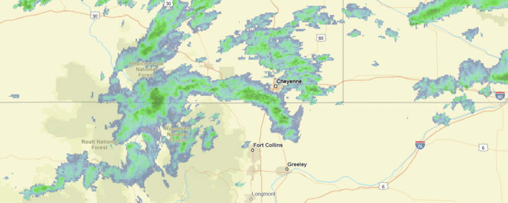
Count me in the “not likely” camp on Sunday thunderstorms. Everything right now just looks like it will show up too far to the south. Not today though, here is radar imagery, with showers heading in from Wyoming.
Comment (1)