We wrote a couple of follow ups recently, from the approximate end of the Atlantic Hurricane Season and the October Forecaster of the Month. It is easy to wonder how different things would have looked if it had been a busy landfalling October, to see where our attention was and how the outlets did, comparatively. As it was, we were all pretty similar in effectiveness.
Nothing to do but watch the thermometer
When we forecast for Sherman last week, expectations were low. It was going to be sunny with some late season warmth, and not a lot of intrigue. The biggest question was how warm would it get on Election Day, and how Accuweather has time to add notes to all their local forecasts. I still have no answer for the second question, but I can tell you it hit 86 last Tuesday, which was warmer than all forecasts. This handed the victory to the warmest forecaster, who happened to be Victoria-Weather.
Actuals: Monday – High 82, Low 63
Tuesday – High 86, Low 63
Grade: A-C
Busy, but not memorable
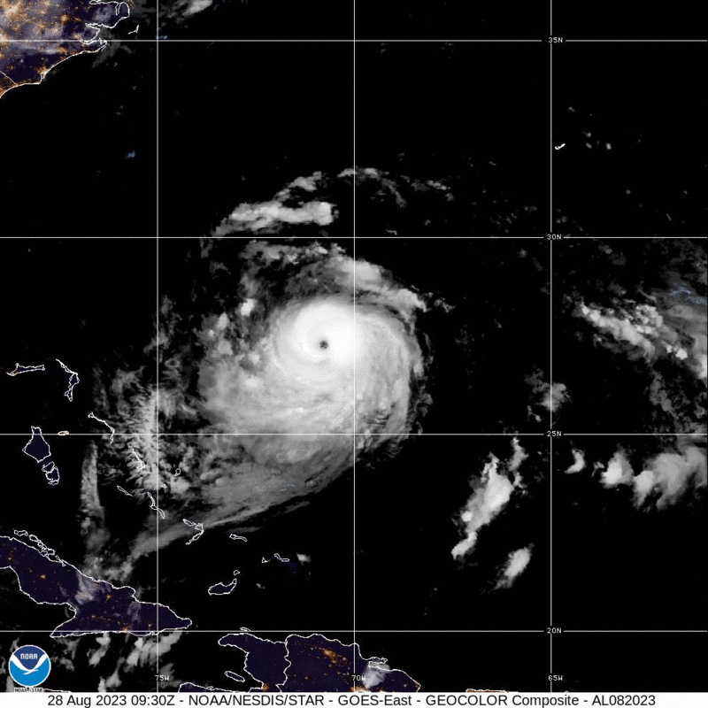
Wow, what a busy, wild Atlantic Hurricane season it has been! Oh, you don’t think so?
Let me run through some stats for you. There were 20 named storms, 7 hurricanes and 3 major hurricanes. That’s a higher than normal number of named storms, and about average on the hurricanes and major storms. Do any of them really stand out in your mind?
Hilary was a Pacific storm that inundated the southwestern US. Otis, North America’s most deadly storm, also came from the Pacific before it blasted Acapulco last month. The Pacific was certainly busier than normal, and saw more storms spiral back into the mainland than normal.
Rare is the season that we remember the Pacific more vividly than the Atlantic, but here we are. The three strongest storms in the Atlantic were Franklin, Idalia and Lee. Lee was the strongest, but managed to avoid large land masses when he was at the strongest, ultimately making landfall in Nova Scotia as a shadow of his former self.
Idalia, if any, is the storm we will remember. Insurance adjusters certainly will, but fortunately, the deadliest, most costly storm of the season claimed just 7 lives, despite hitting impoverished Hispaniola, Cuba and the Yucatan before landfalling in Florida near Apalachee Bay. Idalia did bring some incidental flooding and wind issues to Tampa and Tallahassee, but didn’t make a direct impact on any major population centers, blunting the loss of life as well as reducing the total damages.
In a period of history when we have dealt with deadly storms quite regularly, it’s great to have a year that was more fortunate. Make no mistake, though, this wasn’t a quiet year, just one where the storms kept their distance from the mainland.
The Northern Lights were out in Canada
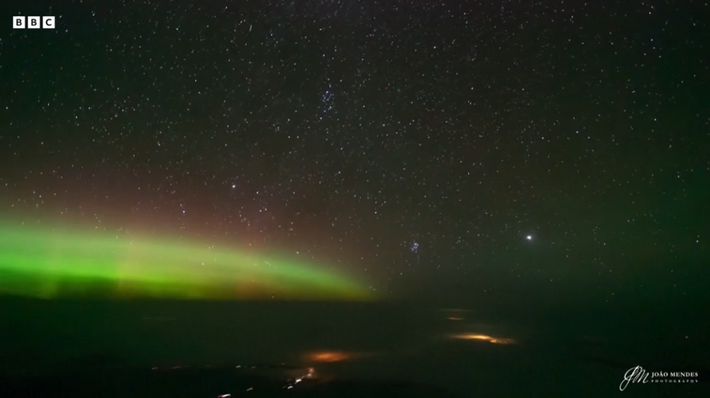
The full video from the BBC is here.
October Forecaster of the Month
It was a busy month of forecasting in October, but the only thing spooky about the month in the end was how closely contested it was. Only the National Weather Service failed to secure even a share of a forecast victory during the month. That meant the rest of the outlets were neck and neck. There was a three way tie for third, and they were only shortly behind Accuweather, who got the slim win.
| Outlet | Forecast Wins (year) |
| Victoria-Weather | 7.83 |
| The Weather Channel | 5.33 |
| Clime | 5.33 |
| WeatherNation | 3.5 |
| Weatherbug | 3.5 |
| Accuweather | 3 |
| National Weather Service | 2.5 |

No volcano concerns for aviation
Remember 2010, when Eyjafjallajökull erupted in Iceland, and kicked up so much ash that it crippled North Atlantic aviation for weeks at a time? Well, there is another large eruption in Iceland anticipated near the Grindavik region, but for now, there are no concerns that there will be similar disruptions.
Temperatures in the early afternoon in Logan are in the upper 40s, should probably settle into the low 50s, just as we all suspected. But that wasn’t where the questions came up. We’ll see what the lows are like tomorrow morning. Dew points are in the mid 20s, which might affect how old it can get over night.
Logan, Utah
Winter is fast approaching, which is great news for members of the skiing and snowboarding community. The Wasatch are certainly poplar spots for that winter weather activity, but are we there yet?
At 951PM, MT, Logan was reporting a temperature of 29 degrees with clear skies and a light northwest wind behind a weak cool front that passed by earlier this morning. Clear skies prevailed across the Beehive State, with a ridge of high pressure nosing into the area from the west.
The jet structure is going to bubble around the Intermountain West, with a southern jet beginning to trough and engender some development in the Mexican Desert, while a ridge will only strengthen in the northern Plains. This will lead to some sustained stability, and late season warmth in Logan.
Tomorrow – Mostly sunny, High 51, Low 23
Sunday – Sunny, High 55, Low 20
TWC: Tomorrow – Sunshine and clouds mixed. High 51, Low 26
Sunday – Except for a few afternoon clouds, mainly sunny. High 56, Low 26
AW: Tomorrow – Mostly sunny High 49, Low 24
Sunday – Brilliant sunshine High 55, Low 21
NWS: Tomorrow – Sunny High 51, Low 26
Sunday – Sunny High 57, Low 29
WB: Tomorrow – Sunny, High 40, Low 29
Sunday – Sunny, High 48, Low 32
WN: Tomorrow – Mostly sunny, High 51, Low 27
Sunday – Mostly Sunny, High 57, Low 27
CLI: Tomorrow – Partly Cloudy, High 50, Low 25
Sunday – Partly Cloudy, High 54, Low 25
All right, here is my guess: The top three outlets and Clime updated their forecasts with the new model guidance already, and the NWS just hasn’t. Guidance clearly is showing a chilly Sunday morning, and it’s already busted on the warm side, so trending colder makes more sense. With this confusion, let’s check with a local perspective, from KSL in Salt Lake City.
A pattern is established
Back before Halloween, we issued a forecast in Cincinnati, in which we were ahead of a fairly active time. A failing cold front was on its way through town, and it did bring a bit of light rain. At the end of the period, we anticipated a warm front climbing to the northeast back into the Cincinnati area, which didn’t come to pass before the period was over. Well, don’t look now, but a warm front is rising through the Ohio Valley again. At least back in November, the clouds and rain will more sparse, allowing for a greater drop in temperature, which won’t be the same this time around. This lead to Victoria-Weather, forecasting cooler, winning the day.
Actuals: October 27th, .02 inches of rain, High 75, Low 62
October 28th, .-03 inches of rain, High 68, Low 54
Grade: B – C
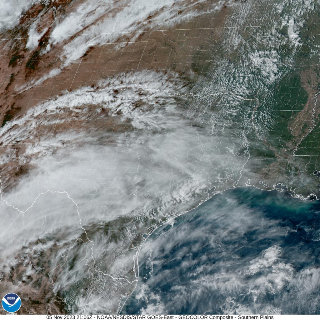
Sherman, Texas
Our forecast takes us to the Red River Valley, northeast of the MetroPlex. The Thanksgiving Holiday is soon approaching, so I have to believe more of us are looking at the weather in even more places.
At 250pm, CT, Sherman was reporting a temperature of 81 degrees with clear skies. While there was a weak jet streak bringing high clouds to central Texas, the strongest flow aloft was well to the north. There was a strong wave of low pressure preparing to develop in the northern High Plains, which will act t draw flow from the south.
The strong jet to the north will usher the surface feature along while forming into a long waved, low amplitude ridge. This will provide stability to the region, and lead to some warmer air and sunny skies.
Tomorrow – Breezy partly cloudy, High 82, Low 61
Tuesday – Sunny, High 85, Low 62
TWC: Tomorrow – A mainly sunny sky, High 82, Low 61
Tuesday – A mainly sunny sky. High 82, Low 62
AW: Tomorrow – Mostly sunny, breezy and very warm; great day to be outside High 82, Low 61
Tuesday – Breezy and very warm with plenty of sunshine; dry weather for getting out to vote High 83, Low 62
NWS: Tomorrow – Sunny, High 79, Low 61
Tuesday – Sunny, High 82, Low 62
WB: Tomorrow – Mostly sunny, High 78, Low 62
Tuesday – Sunny, High 79, Low 63
WN: Tomorrow – Mostly sunny, High 79, Low 61
Tuesday – Mostly sunny, High 82, Low 62
CLI: Tomorrow – Sunny, High 82, Low 60
Tuesday – Sunny High 84, Low 62
A look at the satellite shows that jet streak I mentioned earlier. A look at Accuweather’s forecast shows a bit of editorial commentary suggesting that they had too much free time for this forecast.