There were some signals of cooler weather coming to Winston-Salem last week. A cold front north of the Appalachians, moist flow and overcast from the Atlantic, and the midst of summer’s dog days. The previous several days had been quiet warm, however, and clouds were slow in filling in across the region. Persistence paid off, and warmer forecasters collected the top spots. Victoria-Weather, Accuweather and the Weather Service were tied on the top. Actuals: Wednesday, August 10th, High 92, Low 73 Thursday, August 11th, .01 inches of rain, High 85, Low 73
Late August usually brings out the posts about the coming tropical season and the increasing threat. The peak of the tropical season is less than a month out, and while the NHC continues to forecast a busier than normal season, the Atlantic remains quiet. So we turn our attention to the rest of August in the continental US.
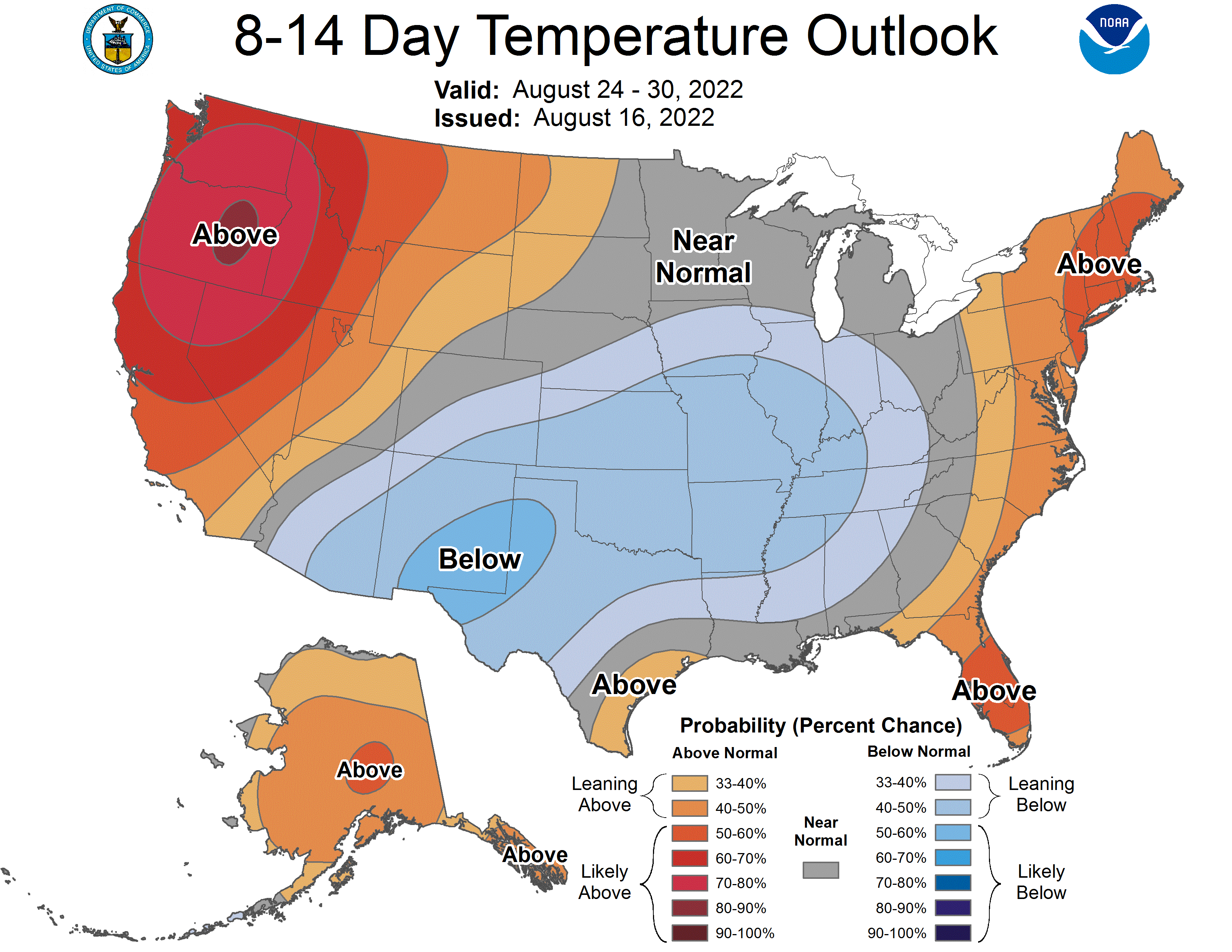
The 8-14 day outlook from the CPC has much of the country in below normal temperatures. This is accompanied by above normal precipitation in the same regions, and as a reminder that summer is still around, a heat wave on the west coast.
Oceans continue to warm through the summer as the sun angle stays strong, which is why late August and September are busiest in the Atlantic, but over large landmasses, air masses are more vulnerable to changes. While the sun is warming the oceans, the angle is reducing, and the jet starts sinking south. There is more variability in the weather pattern, and when there is variability, there is the threat for thunderstorms.
There might be some instinct to believe that the extremely divergent temperatures relative to normal found on the coasts versus that in the middle of the country. Looking at the upper level pattern, though, this doesn’t quite seem likely. Typically weak summertime flow is going to continue until late in this outlook period, which means these cooler temperatures will probably be a result of moisture and cloud cover thanks to an array of surface perturbations.
Shorter waved features are more spurious, and is why there is less confidence in the below normal temperature field than with the warmer regions, which are a result of strong jet stream ridges in the forecast. There isn’t the full level cold air mass in the middle of country to provide the clash of airmass you need for big severe outbreaks. There will certainly be some thunder embedded within all the rain coming Middle America’s way, but not high risk days from the Storm Prediction Center.
Generally, there is usually a late year severe weather peak at the beginning of fall, as cold air really starts to come back to town. Unlike the spring severe season, cold air is denser and tends to completely supplant warm air. Cold air is reinforced, and warm air has a tougher time coming back, so the severe season is shorter than spring, where warm air keeps trying to bubble up.
Like the tropical season this year, we shouldn’t read to much into this quiet October. The hurricane season, like the fall severe season could still get very interesting very quickly.
The metropolitan area is actually Niles-Benton Harbor on most documents, but the airport is at Benton Harbor. How do I title these posts? This is a about as much anxiety as I can get for these forecast post titles.
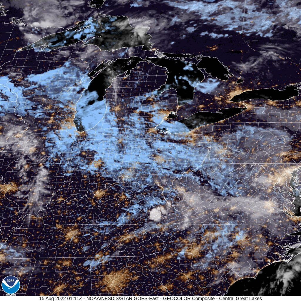
At 853PM, ET, Benton Harbor was reporting a temperature of 67 degrees with overcast skies. Despite high pressure centered over the Great Lakes, a swath of low level clouds was evident on satellite, stretching from Minnesota to western Pennsylvania. The jet runs directly over the top this shield of low level moisture, and the combination of features suggests the clouds are going to stick for a little while. The jet itself is ridging across the Great Lakes, and the surface map is representing this rather curiously. A surface low is staking a spot in the middle of the country, while the ridge in western Ontario is not motivated to move either. With the jet not expected to move measurably, the southwest flank of the ridge will erode, and the stability of the region will break down. Clouds will continue in the area, but particularly on Tuesday, some scattered showers are expected to mix in with them. Tomorrow – Mostly cloudy to overcast, High 75, Low 60 Tuesday – Mostly cloudy, a spot of light rain possible, High 77, Low 61
TWC: Tomorrow – Except for a few afternoon clouds, mainly sunny. High 78, Low 58 Tuesday – Intervals of clouds and sunshine. High 82, Low 60
AW: Tomorrow – Humid with times of clouds and sun High 77, Low 59 Tuesday – Pleasant with times of clouds and sun High 80, Low 59
NWS: Tomorrow – Mostly sunny, High 77, Low 61 Tuesday – Mostly sunny, High 79, Low 59
WB: Tomorrow – Mostly sunny in the morning becoming partly cloudy, High 76, Low 60 Tuesday – Mostly sunny, High 79, Low 61
WN: Tomorrow – Partly cloudy, High 74, Low 62 Tuesday – Partly cloudy, High 78, Low 60
FIO: Tomorrow – Partly cloudy throughout the day. High 81, Low 65 Tuesday – Partly cloudy throughout the day. High 82, Low 64
I know the clouds in Minnesota have really stymied temperatures, much more than forecast for the last couple of days. I’m surprised there is as much optimism as there is for Benton Harbor, further down stream.
This is a very exciting day for me in the forecast realm. Not very often we get to include a hyphen in the forecast city name!
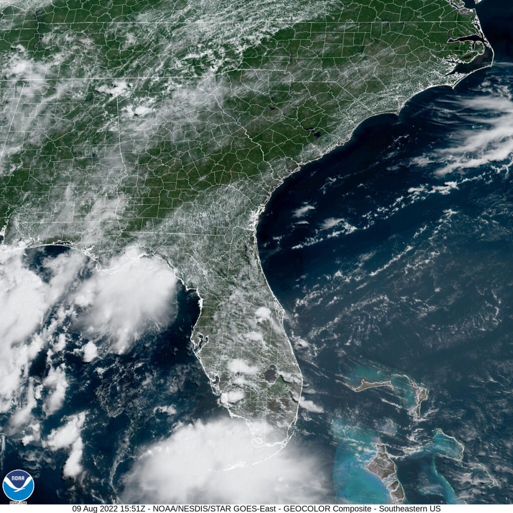
At 954AM, ET, Winston-Salem was reporting clear skies with a temperature of 81 degrees. Clear skies were the boss, but dew points in the low 70s pointed to uncomfortable conditions and the potential for a few clouds today. Some low level convergence suggested a lee trough just to the west of the airport, and the threat for some afternoon showers and storms today, though high pressure dominated the broader map in the Carolinas. This lee trough is going to be the primary factor over the next couple of days. There is colder, dryer air on the other side of the Appalachians, but the jet structure is well into Canada, and will not advance far enough to change the air mass in Winston-Salem. Expect scattered showers and storms in the afternoons through the mid-week. Surface low pressure in eastern Canada may eject some midlayer overcast into the Carolinas on Thursday, bringing temperatures down a tick or two Tomorrow – Mostly cloudy with a chance for some pop up showers, High 90, Low 72 Thursday – Mostly cloudy and at times overcast. Scattered showers, High 86, Low 71
TWC: Tomorrow – Partly cloudy with afternoon showers or thunderstorms. High 87, Low 71 Thursday – Cloudy in the morning with scattered thunderstorms developing later in the day. High 84, Low 70
AW: Tomorrow – Clouds and breaks of sun with a thunderstorm in the afternoon High 90, Low 73 Thursday – Considerable cloudiness with a thunderstorm High 83, Low 71
NWS: Tomorrow – Showers and thunderstorms likely, mainly after 5pm. Mostly sunny, High 90, Low 72 Thursday – A slight chance of showers b73efore noon, then a chance of showers and thunderstorms between noon and 3pm, then showers likely and possibly a thunderstorm after 3pm. Partly sunny, High 86, Low 71
WB: Tomorrow – Mostly sunny. Showers and thunderstorms likely in the afternoon, High 88, Low 73 Thursday – Mostly cloudy. Showers likely with a chance of thunderstorms in the afternoon. High 83, Low 71
FIO: Tomorrow – Humid and mostly cloudy throughout the day. High 83, Low 75 Thursday – Rain overnight and in the morning. High 84, Low 74
It will be nice to ratchet the heat down wherever we can. Some storms are just starting to pop up in the Blue Ridge Mountains to the west as we grabbed this satellite image.
Do you like surprises? I like surprises, so I am a fan of how this month turned out. WeatherNation, who very often gloms on to the Weather Service Forecast, found itself oscillating between the Weather Service, the Weather Channel and sometimes it’s own forecast, and managed to grab the Forecaster of the Month award for the month of July. Cagey strategy, and a big reward.
The Pacific Northwest is had a hot spell at the end of July. Sure, it was not quite as long lasting as the one that came last year, but it was just as hot. Last Friday in Corvallis, hit 99, and was 96 on Saturday. As I said, fortunately, temperatures aren’t still that warm, but they lasted long enough that wild fires really exploded in southern Oregon and northern California. Hopefully, they are more well behaved than in recent years. The forecast in Corvallis was overheated, but a fairly well behaved. The Weather SErvice and WeatherNation drew level on the verification. Friday – High 99, Low 62 Saturday – High 96, Low 62
We’ve made it all the way to August, and we haven’t awarded the FOTM to our June forecaster yet! That is a consequence of the active forecast and road trip schedule we’ve had of late, but now, certainly, is the time to give some meteorologists their due.
June was a mercifully slow start to the summer, with temperatures and storms more manageable than we’ve seen in recent years. July started to go off the rails, but we can appreciate Victoria-Weather’s victory for June with some sort of peace. Congrats to us!
The end of last week in Abilene didn’t promise many changes. A slow, slow moving boundary was sinking towards the Lone Star State, but ultimately, no changes were ever seen in Abilene. Like, none. It was 101 for a high, 80 for a low on each day of our verification, with nary a drop of rain. The Weather Channel and WeatherNation secured a tie for the verification. Actuals: Thursday – High 101, Low 80 Friday – High 101, Low 80