Never sell the SPC short, I will stay that. In our forecast for Sioux Falls, there were only a couple of mentions of severe weather in the forecast last weekend, from ourselves and Accuweather. Meanwhile, Sioux Falls was included in the severe outlook both Saturday and Sunday, and it verified, or did awfully close to town. Saturday had hail, 2 inches in diameter just outside of town. No rain was actually reported in Sioux Falls, however, reflecting the isolated nature of the storms. Sunday was a soaker, with hail (though not as large) and strong winds around town. The low temperature forecasts were volatile, and the rain on Sunday ensured a colder day than expected, so the forecast didn’t turn out great for anyone. Weathernation sneaked in by accurately avoiding rain on Saturday and having a cool low on Sunday. Actuals: Saturday – 92, Low 67 Sunday – .61 inches of rain, High 80, Low 61
Sioux Falls was in the news most recently and on these pages for a massive dust storm that swept the city. Storms may be on the way, but perhaps not as vigorous as the ones seen earlier this month!
At 1256PM, CT, Sioux Falls was seeing clear skies and a temperature of 76 degrees. Warm temperatures were finally filtering back into the Upper Midwest after a cooler stretch to finish May. A broad but transient ridge was sliding through the region, but a similarly broad trough was moving into the Pacific Northwest, leading to cyclogenesis and clouds seen in the western Dakotas. A rippling warm front will pass through the region overnight tonight, developing a few showers and thunderstorms in the area. A warm, muggier day is expected tomorrow, setting the stage for a few afternoon thunderstorms. The system will stall over the High Plains, with another round of wet weather tomorrow night, this time providing a threat of severe weather. The feature will begin to reorganize in the Colorado Plains, and will revitalize the system in the Dakotas. A connective cold front will light up in the evening on Sunday evening, setting a stage for the potential for straight line wind damage. Tonight, tomorrow and Sunday will have a threat of severe weather, with each of the three days featuring stronger weather with more precipitation likely. Tomorrow – Isolated showers early, thunderstorms late, High 88, Low 64 Sunday – Strong storms possible late after a hot partly cloudy day, High 88, Low 67
TWC: Tomorrow – Sunny along with a few clouds. (Late storms) High 91, Low 62 Sunday -Overcast. A stray shower or thunderstorm is possible. High 86, Low 67
AW: Tomorrow – Partial sunshine; breezy in the morning, then becoming humid (late storms) High 90, Low 62 Sunday – Breezy with some sun returning; a severe afternoon t-storm; storms can bring downpours, large hail, damaging winds, and a tornado High 87, Low 67
NWS: Tomorrow – Mostly sunny (early rain, late storms), High 89, Low 62 Sunday – A slight chance of showers and thunderstorms before 7am, then a slight chance of showers and thunderstorms after 1pm. Mostly cloudy, High 88, Low 66
WB: Tomorrow – Sunny (late storms) High 89, Low 63 Sunday – Mostly cloudy in the morning, then partly sunny with a slight chance of showers and thunderstorms in the afternoon, High 89, Low 68
WN: Tomorrow – Mostly sunny, High 89, Low 62 Sunday – Partly cloudy with light rain showers, High 87, Low 63
FIO: Tomorrow – Windy overnight. High 87, Low 61 Sunday – Overcast throughout the day. High 83, Low 68
The paucity of rain forecasts, despite an SPC outlook with a slight or enhanced risk tells you how isolated storms will be. Hopefully, everyone can get out and enjoy the long holiday weekend!
Since we forecast for Sioux Falls, South Dakota has seen two separate large areas of low pressure have moved through the northern Rockies and the northern Plains. The second round brought snow to the central part of the state, and the first came just 2 hours after our forecast period ended, along with blustery winds and thunderstorms. It wasn’t enough to put the forecast verification too far off kilter, and it sure has shifted the season. The Weather Channel earned the victory. Actuals: October 11th, High 73, Low 41 October 12th, High 70, Low 43
We are destined for a three day trek across the western US for our forecast today. This route includes forays along roads that we don’t often see, especially in Wyoming and South Dakota, so that is kind of fun. Also, the idea of an Angelino in South Dakota makes me chuckle. The mileage between the two towns is 1677 miles, and our travels along several highways with 80mph speed limits will allow for a pace of nearly 70mph overall, and 559 miles of ground covered every day. Pretty sweet for a long trip.
DAY ONE (Tuesday)
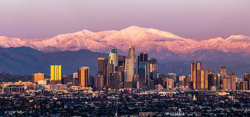
Los Angeles, California
I’m not sure there is an actual location where you can take a picture of downtown Los Angeles with Mount Baldy looming in the background like this, but it’s what most pictures of downtown LA look like, so there must be something. The drive through California into the Lake Havasu area, where we will really start to turn to the north. A massive storm system is moving into the middle of the country and will bring more severe weather to the Plains, but also, significantly, will bring some snow to the Wasatch as we drive just to the east of them on I-15. We’ll stop in Holden, Utah, watching the peaks whiten overnight. Kind of like this picture of Mount Baldy.
DAY TWO (Wednesday) The strong storm will barrel its way out of our route by the time we get moving on Wednesday, but bear in mind that this will be the first winter storm of the season, so even though we are on the interstates, the roads in the passes may still be a little slick. Nothing fresh will be falling through northern Utah or across the vast expanse of Wyoming that we will cover. We will end the day in the paper town of Savageton, which is about 2/3 of the way from Casper to Gillette.
DAY THREE (Thursday) Moving through the Black Hills should be a bit easier than the Rockies and Wasatch were. They are lower, and probably won’t see as much snow, especially at the level I-90 passes through the region. Then, after Rapid City, South Dakota will feature boundless fields of pastureland, and a heck of a lot of sunshine and, most importantly, a speed limit of 80mph.
We’re going to the Dakotas this evening. There was a little bit of rough weather in South Dakota last night. Will the start of the work week bring more of the same?
At 756pm, CT, Sioux Falls was reporting a temperature of 55 degrees with clear skies. There was a complex series of of low pressure bringing rain and areas of strong thunderstorms from the Canadian border and further south, particularly in Oklahoma and Texas, but a swath of clear and cool air had built into the Dakotas. The next trough will rotate into the central Plains after diving out of the Rockies, and is going to bring with it a strong batch of cold air, and quite a bit of vorticity, winding up what will likely be the largest storm of the season. Expect that by late Tuesday, flow will become robustly southerly, with rain starting late in the afternoon and evening. Very windy conditions are expected Tuesday night, with rain heavy in spots. Tomorrow – Mostly sunny, High 71, Low 42 Tuesday – Sunny early, then rainy with very strong winds, even outside o thunderstorms, High 72, Low 41
TWC: Tomorrow – Sunshine and clouds mixed. High 72, Low 44 Tuesday – Plentiful sunshine High 71, Low 43
AW: Tomorrow – Pleasant and warmer with intervals of clouds and sunshine High 72, Low 45 Tuesday – Partly sunny and comfortable (late rain) High 70, Low 44
NWS: Tomorrow – Sunny High 71, Low 44 Tuesday – Sunny, High 70, Low 45
WB: Tomorrow – Sunny, High 71, Low 46 Tuesday – Sunny, High 70, Low 46
WN: Tomorrow – Mostly sunny, High 71, Low 44 Tuesday – Mostly sunny, High 69, Low 44
FIO: Tomorrow – Clear throughout the day. High 71, Low 45 Tuesday – Clear throughout the day. High 70, Low 45
It’s not a matter of if, but when it will rain in Sioux Falls. At least they aren’t in Wyoming and Montana, where snow is likely. And at least for tonight, it’s pretty OK.