We put together a forecast for Milwaukee shortly after the 4th of July, and it was not an altogether summerly forecast. Last Thursday was plenty warm, but a weak wave rippling through the region Friday made for a decidedly different day than one would expect from July. The clouds and light rain kept temperatures from rising above 72. Not exactly anyone’s idea of a hot Friday night. Forecast outlets generally didn’t want to bear the bad news that the first Friday of July wouldn’t be so wonderful, so it was the emotionless computers at Forecast.io that claimed victory. Actuals: Thursday – High 80, Low 64 Friday – .05 inches of rain, High 72, Low 66
I enjoy a good trip to the Cheese State every now and then. It’s right next door to Victoria-Weather in Minnesota, but it seems so completely alien…
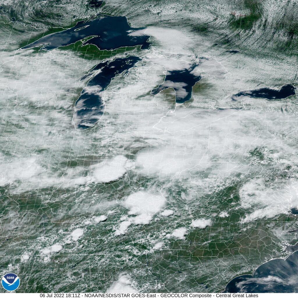
At 103PM, CT, Milwaukee was reporting mostly cloudy skies with a temperature of 70 degrees. Cloudy skies were widespread across the Great Lakes, as an area of low pressure was slogging through the Canadian Maritimes. While a weak jet ridge was emerging over western Ontario, which was helping build high pressure in the northern Great Lakes, a connector front between the low in New Brunswick and a lee trough kept a chance for precipitation south of Milwaukee. High pressure is going to remain in place, but fairly weak through the end of the work week. Generally westerly flow will mean generally stable conditions, though with some passing clouds. Guidance is in agreement about a wave moving into the region overnight Thursday into Friday, bringing some showers to end the workweek. The rain won’t last all day, and there will be some clearing by nightfall. Tomorrow – Partly cloudy, increasing clouds late with a chance of a storm, High 78, Low 64 Friday – Rain, especially early, with clouds and cooler conditions, High 76, Low 65
TWC: Tomorrow – Partly cloudy skies during the morning hours will become overcast in the afternoon. A stray shower or thunderstorm is possible. High 78, Low 64 Friday – Rain showers early with mostly cloudy conditions later in the day. High 71, Low 66
AW: Tomorrow – Humid and warmer with times of clouds and sun; a thunderstorm in spots in the afternoon High 79, Low 60 Friday – Times of clouds and sun High 76, Low 64
NWS: Tomorrow – A slight chance of showers between 10am and 1pm, then a slight chance of showers and thunderstorms after 1pm. Mostly cloudy High 76, Low 63 Friday – A 30 percent chance of showers before 1pm. Mostly cloudy, then gradually becoming sunny, High 75, Low 66
WB: Tomorrow – Mostly cloudy. Chance of light showers and slight chance of a thunderstorms in the late morning and afternoon. High 78, Low 62 Friday – Partly cloudy with a 30 percent chance of light showers. High 71, Low 66
WN: Tomorrow – Mostly cloudy, High 74, Low 63 Friday – Partly cloudy with scattered showers, High 73, Low 66
FIO: Tomorrow – Mostly cloudy throughout the day. High 78, Low 64 Friday – Possible light rain in the morning. High 72, Low 66
On the whole, I am confused by the group of forecasts! I am far more aggressive with the rain forecasts on Friday than anyone, but everyone is all over the map. The same neighborhood, I guess, but timing is very different all over. Maybe all these clouds have something to do with the confusion.
The snowbirds are returning to the north, and while I don’t think Albany is a bit vacation destination, I would imagine there are several people travelling through or near Albany. This particular drive will last two days and cover 992 miles. The drive snakes through some larger towns, and not as much open country as would be conducive to a fast trip, so our pace will be about 65mph, with a day 1 journey of 523 miles, with a little bit shorter day to end it. Go home, Snowbirds!
DAY ONE (Friday)
Albany, Georgia
What do I always say about spring and fall? The systems are bigger and badder, thanks to the clash of air masses, and the system that brought tornadoes to Austin and New Orleans, and continues to bring rain to the east coast, will linger on the Eastern Seaboard as we depart tomorrow, thanks to a deep occlusion and the whole beast just spinning itself over the Great Lakes. Our drive through Georgia and Tennessee will be just fine, but don’t be surprised to see clouds ahead of us when we reach Horse Cave, Kentucky. Lingering light precipitation isn’t moving too quickly thanks to the bogged down system. Horse Cave is near Mammoth Cave, so get away from all the weather worries and just go underground!
DAY TWO (Saturday) Guidance suggests a lot more movement as the weekend approaches, but I’m not as optimistic. I don’t think it is going to be fully cleared out, say north from Indianapolis, as the models project. It will be chilly and cloudy, with lingering moisture. I would, therefore, anticipate a wet snowflake to fall at any moment as we trudge through Chicago and on north into Milwaukee. Everything slows traffic in Chi-town, but this should be a mild dose of it. Even if it takes a while for this precipitation to shove off, Sunday in Milwaukee should start to look like spring.