A fine New England weekend

That first weekend after the 4th of July is the first intensively “summer” weekend of the year. Laze around, if you want to, go to the lake or the cabin or whatever it is that you do. That first weekend in Manchester was pretty great. Temperatures were in the 80s, and an inactive cold front Friday into Saturday morning brought dew points down a little bit, and kept it from getting uncomfortable. Victoria-Weather and Forecast.io came together for the top forecast, hedging warmer for highs and cooler for lows.
Actuals: Friday 7/8 – High 86, Low 65
Saturday 7/9 – High 82, Low 61

Grade: A – B

Manchester, New Hampshire

Manchester in the US is in New Hampshire. In England, Hampshire is nowhere near Manchester (which is its own county, between Lancashire and Cheshire). There is a Portsmouth in both New and original Hampshire, but we’re here to talk about Manchester.

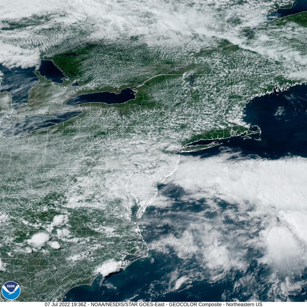
At 253PM, ET, Manchester was reporting a temperature of 82 degrees with mostly cloudy skies. Low pressure over the Atlantic, south of Greenland was parenting an inverted trough over northern Quebec that ran to central Ontario. Between the two disturbances was a rife spot for some midlevel instability, and some spotty clouds. Disturbed weather to the south is more impressive on satellite, but is not going to pose a wet threat for Manchester.
The remnant wave in pursuit of the Greenland low will pivot into New England through the day on Friday. The parent remnant trough will actually start to redevelop, and with it, so too will the local jet. By this point, moisture associated with the feature will be spent in the White Mountains, and instead, a crisp change to the air mass will take hold overnight Friday into Saturday, making for a pleasant summer weekend.
Tomorrow – Partly to mostly cloudy, High 87, Low 64
Saturday – Clearing and pleasant, High 82, Low 62

TWC: Tomorrow – Partly cloudy skies. High 86, Low 63
Saturday – Sunshine and clouds mixed High 81, Low 64

AW: Tomorrow – Clouds and sun High 87, Low 65
Saturday – Mostly sunny; a beautiful start to the weekend High 80, Low 63

NWS: Tomorrow – Patchy fog before 8am. Otherwise, mostly sunny, High 86, Low 62
Saturday – Sunny, High 79, Low 61

WB: Tomorrow – Partly sunny, High 86, Low 65
Saturday – Mostly sunny, High 79, Low 65

WN: Tomorrow – Mostly sunny, High 86, Low 61
Saturday – Mostly sunny, High 79, Low 61

FIO: Tomorrow – Mostly cloudy throughout the day. High 86, Low 64
Saturday – Partly cloudy throughout the day. High 81, Low 62

That looks like some nice weather on it’s way! I’m surprised the forecast wasn’t a bit warmer tomorrow for a lot of outlets, but I wasn’t going to go any higher, so maybe I shouldn’t be that surprised!

Pocatello, Idaho to Manchester, New Hampshire

It is a hot and active time in the northern US right now. Where there are no storms, there is blistering heat, but where there are storms, the heat abates. What will we contend with? The heat? The storms? Certainly the humidity? The only way to know is to look into the future, as we forecast for this 4 1/2 day trip, which will cover 2,463 miles. We will collect 532 miles a day. at a modest 66.5mph

DAY ONE (Tuesday)

Pocatello, Idaho

DAY ONE (Thursday)
While things have been a bit tumultuous this week, the biggest, baddest area of low pressure in the Plains is lifting towards Hudson Bay, as though it were a regular winter feature. This will provide a modicum of relieve for waterlogged farmers in the northern Plains, and a great deal of relief for anyone navigating the wilds of Idaho and Wyoming, as we will. There won’t be much to get in our way as we trek eastward, stopping in Egbert, Wyoming by night’s end.

DAY TWO (Friday)
Flow over the mountains will continue to be westerly, and as it ever does, it will fill in the gap behind the previous system with another lee trough. It will be tapped of moisture, though, and will function only to accelerate the warm air from the Gulf to the Plains. Hot and stick in Nebraska, and western Iowa, where we will alight upon Wiota, west of Des Moines, for the night.

DAY THREE (Saturday)
That advancing area of low pressure will start causing problems on our Saturday drive. The GFS, generally agreed to be more reliable in the longer term is indicating widespread precipitation from Iowa to Illinois and Indiana, though I suspect that is a resolution issue. Instead, it’s going to be hot and humid all day, with only a stray thunderstorm here or there. Granted, those storms will likely dump a lot of rain where ever they do show up, which will severely cramp our style. The drive will end in Howe, Indiana, off of the Indiana Toll Road. when we get there depends on how bound up a stray thunderstorm makes Chicago.

DAY FOUR (Sunday)
That area of low pressure from earlier in the trip, the one that we noted would be headed towards Hudson Bay? Well, he’s still going to be there, just hanging out. This will lead to much of the eastern third of the country being active, though not in a terribly organized way. Scattered thunderstorms cropping up in the heat of the day, without any semblance of a plan. This will require us to be vigilant with the wipers from Howe to Syracuse, though there is a chance those showers start tapering off as we role into Syracuse for the night.

DAY FIVE (Monday)
The mishmash of showery humid air will organize a bit to start next week. In New England and New York, this can be a bit more dangerous because of all the tree coverage. A bit of wind can block roadways for hours with the debris. don’t be surprised to see extra traffic through Albany and on to Massachusetts and southern New Hampshire.

Manchester, New Hampshire