Off to the races we go, with a very I-95 dependent journey north along the east coast. It will take two days, the first longer than the second, to cover the 909 miles between our two cities. That will equate to a pace of 64mph, which is probably going to be slowed by traffic. Our goal for night one is 514 miles, which is more than halfway there. Wait…. Does this route go through New Jersey?
DAY ONE (Wednesday)
Hinesville, Georgia
A rainy area of low pressure that’s been bothering the southeast is finally off shore, and anyone driving the region tomorrow will enjoy pleasant conditions across the coastal Carolinas. We will pass into Virginia, and end the day on the north side of Richmond, in Ashland.
DAY TWO (Thursday) A weak wave is going to spin out of eastern Canada, into New England. There shouldn’t be enough moisture at the surface to impact the roads, but from about Baltimore onwards, expect an uptick in wind and a bit more overcast. It will be at the gloomiest as we reach Poughkeepsie.
We’re ending the summer with a long trip across the country. It will take 4 and a half days, covering 2568 miles. That puts us on a brisk pace of 69.4mph, which won’t seem as great, since we will be on this pace for the better part of a week. The result of each day of driving will be 555 miles traveled. Not bad at all, actually, even if it will still take until Thursday to arrive.
DAY ONE (Sunday)
Hinesville, Georgia
Low pressure in the Great Lakes is demonstrating a nearly perfect comma shape, dangling a cold front from its eastern periphery southwestward towards the southern Plains. The front itself is in pretty rough shape, speaking of precipitation, and isn’t bringing a wintry onslaught, thanks to another system up in northern Canada., but it is going to dangle into our day one route. driving through Georgia and Alabama should mostly be ok, but some isolated showers and storms may pop up at the end of the day’s drive near the Alabama-Mississippi border. They shouldn’t be too obtrusive, but certainly possible. The day ends in Hickory Flat, Mississippi.
DAY TWO (Monday)
The front will be behind us as we leave on Labor Day morning, and while it will probably be cloudy until we hit Arkansas, it shouldn’t be rainy. The sun will be out not long after we reach Arkansas, and we will enjoy the sunshine all the way to Yukon, an Oklahoma City suburb.
DAY THREE (Tuesday)
Even a subsequent area of low pressure churning through the northern Plains and Great Lakes won’t be enough to pull up a return flow into west Texas. The drive from Oklahoma to New Mexico will be dusty and lonely. We’ll make it past Albuquerque, and the day will conclude in Highland Meadows, which is about 20 minutes west of Albuquerque.
DAY FOUR (Wednesday)
The drought continues in the west, and as if to confirm that for us, we will drive through Arizona, which is desertified at the best of times, and end our drive in the Mohave Natural Preserve about an hour into California. About 5 hours left for our Thursday in some blistering heat.
DAY FIVE (Thursday)
Make sure that AC is working. We’ll turn north at Barstow, and it will remain plenty toasty all the way up past Fresno and into Madera. Don’t be surprised if 110’s buckle roads for the last stretch of the drive. Some clouds my finally cool things down on our first full day in Madera, but it sure will be hot when we arrive.
The coast of Georgia seems to be growing as a tourist destination. Now that we are headed to the autumn, it’s time to start thinking about going some place war.
At 836PM, ET, Hinesville was reporting a temperature of 82 degrees with partly cloudy skies. The remnant Ida remains impactful over the mid – Atlantic, where tornado watches are bracketing the New York City area, but as it reaches the higher latitudes, it is demonstrating traits of a subtropical low, including a ranging cold front that slides south of the Brunswick area. Showers and thunderstorms are seen as near as Valdosta, but is moving away from Hinesville. The boundary is expected to act as a barrier to onshore flow for the remainder of the work week. Expect a mostly sunny start to September, though the stalled boundary, which will be over north Florida Thursday and Friday, will lead to some waves of clouds in Hinesville. Tomorrow – Partly cloudy, High 89, Low 72 Friday – Mostly sunny, High 88, Low 68
TWC: Tomorrow – Sunny along with a few clouds. A stray shower or thunderstorm is possible. High 89, Low 72 Friday – Except for a few afternoon clouds, mainly sunny. High 86, Low 68
AW: Tomorrow – Intervals of clouds and sun High 89, Low 74 Friday – Partly sunny; noticeably less humid than recent days High 87, Low 70
NWS: Tomorrow – A 30 percent chance of showers and thunderstorms, mainly after 5pm. Mostly sunny, High 90, Low 71 Friday – Sunny, High 89, Low 69
WB: Tomorrow – Mostly sunny, a slight chance of showers and thunderstorms in the afternoon, High 88, Low 74 Friday – Sunny, High 85, Low 71
WN: tomorrow – Partly cloudy with isolated storms, High 90, Low 71 Friday – Mostly sunny, High 89, Low 68
FIO: Tomorrow – Humid and partly cloudy throughout the day. High 89, Low 73 Friday – Humid and partly cloudy throughout the day. High 87, Low 68
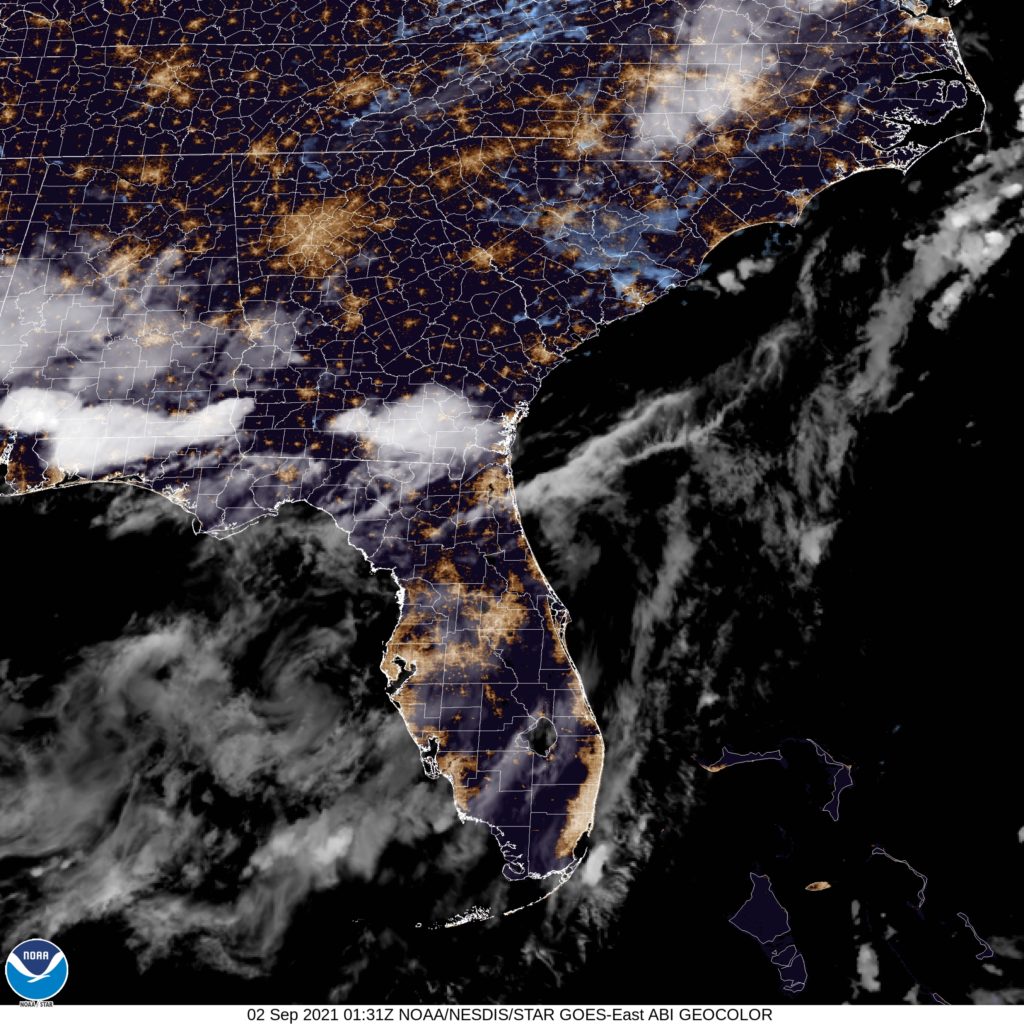
I think the storm activity will stay to the south of Hinesville, but it appears to be a point of contention among the various outlets. Here is a look at the satellite, showing some storms in south Georgia.
There are a lot of reasons that storm systems or wet weather don’t ever reach a location. Rather than coming up with the explanation on a per occasion basis, a lot of people just say that there was a force field around a city. Sure, there was the system moving through the Tennessee Valley towards the coast towards Hinesville last week, but I think we can just say it didn’t rain there because of a force field. earned victory. Actuals: Tuesday (14th) – High 79, Low 60 Wednesday (15th) – High 77, Low 62
The current pattern as it stands features a broad trough that doesn’t want to move. The exit arm has roughly been in the area of the Appalachians, give or take a few miles, which has meant an active start to the year in the southeast, and fairly warm January for a lot of people. Will those trends continue this week in Hinesville?
At 1256PM, ET, Hinesville was reporting a temperature of 78 degrees with mostly cloudy skies. A feature tucked from the southern Appalachians west-southwest towards the Mississippi Valley was drawing a moisture rich flow across already rain soaked lands, and overcast was common in Georgia, but parts of the coast have broken out, and temperatures in the region were 10 degrees or so warmer than interior parts of the state. The instability derives from jets converging in the southern Appalachians, rather than from the tail of an advancing boundary, the light to moderate rain will remain in place over the interior southeast for the next couple of days. While no significant rain is in the forecast, the continued moisture filled flow across the region will lend itself to some early morning fog and low clouds, with a stray, isolated shower or thunderstorm in the afternoon for each of the next two days. Tomorrow – Mostly cloudy, especially early, High 79, low 60 Wednesday – Mostly cloudy with a chance of some drizzle before sunrise, High 80, Low 60
TWC: Tomorrow – Cloudy skies. High 80, Low 63 Wednesday – Sunshine and clouds mixed. High 81, Low 60
AW: Tomorrow – Areas of fog in the morning; otherwise, mainly cloudy and very warm, High 80, Low 64 Wednesday- Considerable cloudiness and very warm High 80, Low 61
NWS: Tomorrow – Areas of dense fog before 11am. Otherwise, mostly cloudy High 79, Low 62 Wednesday – Partly sunny, High 80, Low 61
WB: Tomorrow – Areas of dense fog in the morning. Mostly cloudy. Visibility of a quarter mile or less at times in the morning. High 79, low 63 Wednesday – Partly sunny, High 79, low 62
WN: Tomorrow – Mostly cloudy, high 79, low 62 Wednesday – Partly cloudy, High 80, low 61
FIO: Tomorrow – Overcast throughout the day. High 81, Low 62 Wednesday – Partly cloudy throughout the day. High 80, Low 61
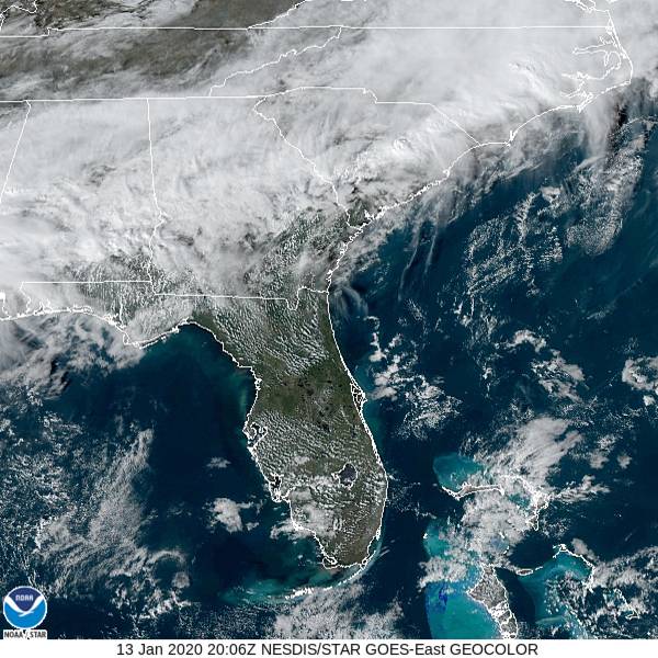
Not often that I am the most skeptical of an areas chances at staying dry. If they see anything, it will just be a spritz, and barely noticeable, but with this much moisture in the region, it’s hard to rule out. Take a look at the local satellite, which is showing quite a bit of cloud cover.