If you go back and look at the forecast for Punta Gorda, you will see that, mysteriously, I said on the 8th it would be mostly sunny through the day, late evening…. and then I let it hang. If I had concluded that statement with “showers” or something like that, Victoria-Weather would have drawn level with Weatherbug for the forecast victory, but that wasn’t how it shook out. Instead, Weatherbug was the sole victor thanks largely to their uncomfortably warm low temperature forecast which matched the uncomfortably warm nights in Punta Gorda. Victoria-Weather would have been close if we’d employed the correct precipitation forecast, because we were the only outlet that anticipated how warm it would be during the day. Actuals: July 7th, .01 inches of rain, High 95, Low 80 July 8th, .02 inches of rain, High 95, Low 81
Hurricane season is off to a daunting start, with Beryl already bringing category 4 and 5 damage to islands in the Caribbean, and poised to bring soaking rain to Mexico and the Texas Coast through the remainder of the weekend. Southwest Florida has become a hurricane hot spot over the last few years, after a long era of quiet, and perhaps a bit of complacency, residents of Punta Gorda are going to be eying the tropics more warily.
At 353PM, ET, Punta Gorda was reporting a temperature of 94 degrees with clear skies. Despite Beryl churning, expecting to become a hurricane again before landfalling near Corpus Christi tomorrow, there was a bit of diurnal thunderstorm activity beginning to fire along the coast in Florida near Sarasota, and south of the area, over the Everglades. This activity will continue through the evening, feasting on temperatures in the 90s. There is a trough through the southeastern US and touching off storms, particularly in Georgia, and this boundary is helping to draw southerly flow across the Sunshine state and exasperating the threat of storms. A weak subtropical feature will drift into the Jacksonville area and make storms more widespread across Florida. The added circulation across the area will tap into the broad Floridian instability, and late Monday looks to be even stormier than today and tomorrow. Tomorrow – Isolated thunderstorms, High 95, Low 77 Monday – Mostly sunny through the day, late evening 93, Low 77
TWC: Tomorrow – Partly cloudy early with thunderstorms becoming likely during the afternoon. High 92, Low 78 Monday – Mostly cloudy in the morning with scattered thunderstorms developing later in the day. High 91, Low 79
AW: Tomorrow – Humid with variable cloudiness; a thunderstorm in the afternoon High 94, Low 77 Monday – Humid with some sun, then turning cloudy High 89, Low 77
NWS: Tomorrow – Scattered showers and thunderstorms, then showers likely and possibly a thunderstorm after 5pm. Mostly sunny High 90. Low 79 Monday – Scattered showers and thunderstorms between 8am and 2pm, then showers likely and possibly a thunderstorm after 2pm. Mostly sunny High 90 Low 79
WB: Tomorrow – Mostly sunny, isolated showers and thunderstorms in the morning, becoming scattered showers and thunderstorms in the afternoon. High 91, Low 79 Monday – Mostly sunny. Scattered showers with isolated thunderstorms in the morning then numerous showers and scattered thunderstorms in the afternoon, High 92, Low 80
WN: Tomorrow – Partly cloudy with scattered storms, High 90, Low 79 Monday – Partly cloudy with numerous showers and scattered thunderstorms, High 89, Low 79
CLI: Tomorrow – Thunderstorm, High 91, Low 79 Monday – Thunderstorm, High 90, Low 78
Clime says just the one thunderstorm in Punta Gorda. I’m going a bit warmer than the rest, following their warm day in Punta Gorda today. A look at the satellite of tropics shows that Beryl isn’t a large storm, but is on her way to Texas.
I know you’ve been waiting a long time for this verification, as the forecast was issued in December 9th, but that’s just the type of thing the holidays do to you. I’m happy to report good news from Punta Gorda, though. Victoria-Weather ended up getting the top forecast in southwest Florida, which will go down as a victory in my last forecast of the year. Hooray! Actuals: December 10th – High 83, low 60 December 11th – Trace of rain, High 85, low 65
We’re crossing the Sunshine State today, from the southeastern coast to the west coast. Of course, everyone calls it the Gulf Coast, but we’re not here for a geography lesson. (unless you are, and then I’m sorry for the confusion)
At 453PM, ET, Punta Gorda was reporting a temperature of 78 degrees with fair skies. Nearby spots, like Fort Myers were popping up into the low 80s as the region was encompassed by high pressure ahead of a cold front advancing through the southeastern US. As the boundary moves closer to the coast, moisture will become entrained across the Florida Peninsula. The boundary itself won’t ever arrive in Punta Gorda, but the more aggressive breezes across the area, from southwest to northeast, will be conducive to a few isolated showers and storms. The activity will largely be in the middle of the state, but it’s never a bad idea to include thunderstorms in a Floridian forecast. Tomorrow – Mostly sunny, warm, High 86, Low 63 Wednesday – Isolated thunderstorms, High 85, Low 65
TWC: Tomorrow – Partly cloudy skies. High 85, Low 62 Wednesday – Intervals of clouds and sunshine. High 84, Low 66
AW: Tomorrow – Sunny to partly cloudy and pleasant High 81, Low 66 Wednesday – Partly sunny, very warm and more humid with a shower in places in the afternoon High 86, Low 61
NWS: Tomorrow – Partly sunny, High 80, Low 66 Wednesday – A 30 percent chance of showers, mainly after 1pm. Mostly sunny, High 80, Low 69
WB: Tomorrow – Mostly cloudy High 84, Low 63 Wednesday – Partly cloudy. A slight chance of showers in the afternoon. High 83, Low 66
WN: Tomorrow – Partly cloudy High 82, Low 65 Wednesday – Partly cloudy with scattered showers, High 82, Low 68
FIO: Tomorrow – Clear throughout the day. High 84, Low 63 Wednesday – Partly cloudy throughout the day. High 83. Low 67
Here is a look at the forecast for the next few days from Fox 4 in Fort Myers, just down the road from Punta Gorda.
I know how great vacation can be, but driving to Florida along the East Coast seems like such a challenge. But then, getting to La Guardia from Bridgeport doesn’t seem like a lot of fun either, so a 2 and a half day trip it is! We’ll meander over the course of 2 1/2 days at a pace of 62.6mph, which as you should know by now, isn’t very fast. We will cover barely over 500 miles a day on days one and two, with the rest of our 1284 mile journey reserved for Saturday.
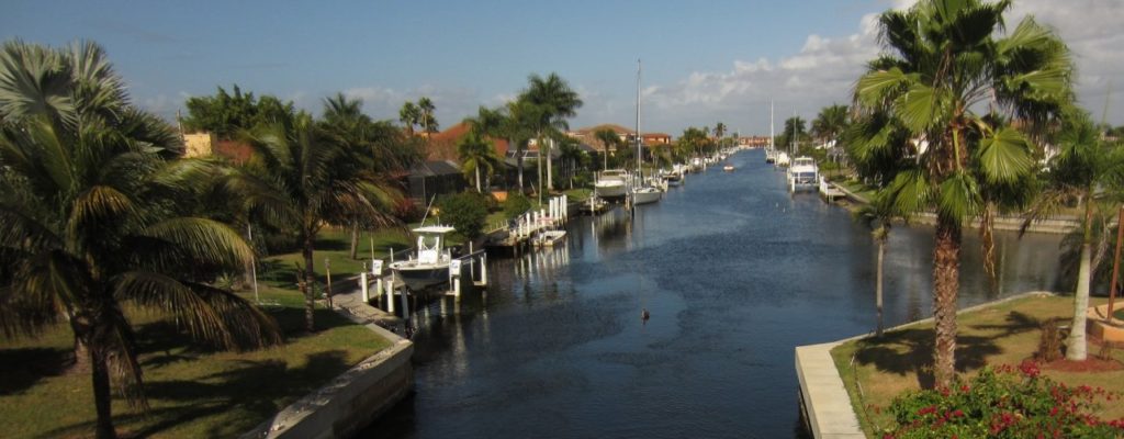
Punta Gorda, Florida
DAY ONE (Thursday) This is the rare August in which the southeast is somewhat synoptically active. There are a lot of showers and storms in the northeastern Gulf as high pressure sinks into the Carolinas. The daily convection in the southeast will likely not make it further north than Gainesville, which means that if we start early enough, we should stay dry all day. Well, save for the sweat we break out into every time we stop for gas. It’s still going to be hot and humid, until we reach Gable, South Carolina, southeast of Sumter. This blog is very into Sumter right now.
DAY TWO (Friday) High pressure won’t last long in the face of August heat and humidity in the southeast. Alas, a blob of moisture will waft north into Georgia and the Carolinas. We should be sneaking into Virginia by the time it really gets active, but with the moisture wrapping into the eastern exposures of the Shenandoahs and Blue Ridge, don’t be surprised to see some late afternoon haze and clouds, even as far north as Havre du Grace, Maryland, at the northern end of Chesapeake Bay, and our terminus for the day.
DAY THREE (Saturday) Further north, high pressure often has a greater toehold, and that will be the case on Saturday. A wedge of dry air associated with low pressure in Canada will make itself at home in between the moisture blob to the south and that same area of low pressure. It’s going to be a bit of an intense day of driving, as we pass through the southern and eastern parts of the Philadelphia metro, and then right through the heart of New York, but it should be worth it, as Bridgeport is in for a fantastic start to the weekend.