The same system that brought such devastating weather to the Ohio Valley was also responsible for putting a chill in the mid-Atlantic. When we forecast for Lynchburg almost two weeks ago, nobody anticipated the plummeting temperatures on the evening of December 12th. We all more or less suspected a non-standard day, but not THIS non-standard. It was 27 degrees by the time the 12th turned to the 13th, and forecasts busted across the board. The fast arriving front also prevented record highs on Saturday, which was against the grain for some outlets as well. Forecast.io ended up collecting the wind, mitigating their losses with a cooler forecast. Actuals: Saturday, December 12th: .28 inches of rain in thunderstorms, High 66, Low 49 Sunday, December 13th, High 50, Low 27
The holidays are upon us and travel is going to be much more common this year than it was last year. How will it be, going from one place to another tomorrow, especially along the 712 mile stretch between Lynchburg and Grand Rapids. We’re going to cover it all in one day, at a pace of 63.2mph. It is going to be a long drive, so make sure you hit the restroom before we hit the road.
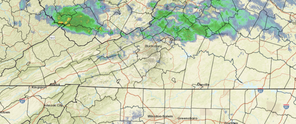
Lynchburg, Virginia
The next system is getting ready to develop in the Ohio Valley, and it’s sure nice to not have to describe it in apocalyptic terms. Still, for a road trip through the region, it’s still going to introduce challenges to our itinerary. The warm front associated with this system will have lifted north of Lynchburg and most of Virginia by the time we set forth on Saturday, but the warm southerly flow will potentially lead to a stray spot of drizzle, and the associated moisture may lead to some fog in the mountains of West Virginia. The reain will begin in earnest after we hit about Athens, Ohio, and will continue across the Buckeye State. It will be overcast when we reach Michigan, but the precipitation will be moving out of the state. Expect some wet flakes to mix in with the rain, maybe as early as Toledo, but the precipitation will wind down around Battle Creek. Given the wind dynamics, chill to the air and the presence of a Great Lake to the west, there could be a fewbands of lake effect snow in western Michigan, of which, one may linger in Grand Rapids for our arrival.
Grand Rapids, Michigan By Rachel Kramer – https://www.flickr.com/photos/rkramer62/3965913452/, CC BY 2.0, https://commons.wikimedia.org/w/index.php?curid=108742650
We are headed smack dab into the middle of Virginia for our forecast. There is snow on the ground in this part of the country, but what can be said about Virginia this weekend?
At 1054AM, ET, Lynchburg was reporting a temperature of 47 degrees with mostly cloudy skies. The overcast is ahead of a warm front associated with a vast area of low pressure in the Plains. Moisture will be more plentiful on the western side of the Appalachians, but some light drizzle is still possible this afternoon. When skies clear this afternoon, expect a significant warm up, which will only continue on Saturday. The cold front will arrive with vigor on Saturday evening. While strong and severe weather is anticipated in the mid-Mississippi Valley today and tonight, the teeth will be taken out of the storm. There could be some strong winds, but the continuing elongation of the trough and the disruption caused by the mountains will ensure that the storm won’t have the tornado or heavy rain threat seen today. The front will move through quickly, leading to a cool, dry day on Sunday. The upper trough is going to flatten through the Mid-Atlantic, and in conjunction with post-frontal downsloping, the temperature drop will be blunted, but the dry air will remain. Tomorrow – Showers and thunderstorms in the evening, High 71, Low 47 Sunday – Clearer and cooler, High 54, Low 39
TWC: Tomorrow – Cloudy skies with periods of rain later in the day. Thunder possible. High 70, Low 48 Sunday – A mainly sunny sky. High 53, Low 39
AW: Tomorrow – Mostly cloudy and becoming windier with the temperature near the record of 71 set in 2015; a shower and t-storm in the afternoon High 70, Low 49 Sunday – Mostly sunny and cooler High 53, Low 39
NWS: Tomorrow – A chance of showers before 4pm, then showers and possibly a thunderstorm between 4pm and 5pm, then showers after 5pm. Some of the storms could produce gusty winds. High 69, Low 48 Sunday – Sunny, High 52, Low 36
WB: Tomorrow – Cloudy. Slight chance of a thunderstorm in the afternoon. Some thunderstorms might cause gusty winds in the afternoon. High 66, Low 49 Sunday – Sunny, High 51, Low 39
WN: Tomorrow – Mostly cloudy with light showers and isolated storms, High 68, Low 39 Sunday – Sunny, High 52, Low 36
FIO: Tomorrow – Rain in the evening. High 69, Low 51 Sunday – Clear throughout the day. High 52, Low 32
Looks like that warm frontal rain has reached Lynchburg since this forecast began! The real weather story for the region will be tomorrow afternoon with a cold front, from a system that is causing big problems in the middle of the country right now.