Our last post of March was actually a forecast that covered the first couple of days of April in Boston. I have to say, it is not weather that I would have enjoyed. After a very rainy start to the month on the 1st, temperatures struggled to even reach 40 on Friday the 2nd. If there was a silver lining, it certainly wasn’t for Bostonians, but rather for Victoria-Weather, who easily won the day. Actuals: Thursday, April 1st, .98″ of rain, High 58, Low 36 Friday, April 2nd, High 40, Low 29
Baseball season starts tomorrow. The Red Sox may not be the team they have been in recent years, but baseball is a signal of a new spring and summer season, and I’m sure Boston fans are excited anyways.
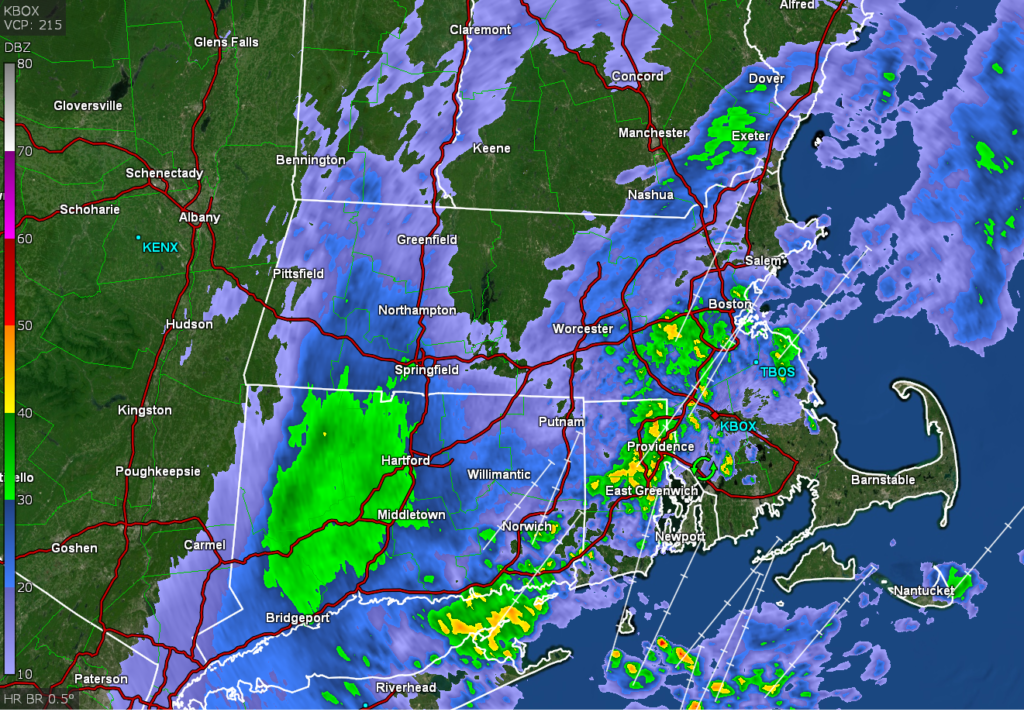
At 1054PM, ET, Boston was reporting rain with a temperature of 57 degrees. A strong, sharp upper level trough is moving from the Great Lakes to the East Coast. Presently, surface low pressure is centered well into Nunavut, but along a ranging cold front, the base of the trough has fostered more cyclonic development in the mid-Atlantic. Surface low pressure will streak through southern New England shortly after midnight. Wind and rain will continue overnight, with the back end of the rain shifting out of the area in the late morning hours. Cold air will become cut off behind the system over New England. While skies will largely be clear thanks to the subsidence of the heavier, denser cold air, it won’t feel particularly warm. Not only will the cold air pocket be in place, but winds will be steady. Tomorrow – Rain lasting through the morning, then clearing and still brisk. High 55, Low 36 Friday – Mostly sunny and chilly, High 42, Low 29
TWC: Tomorrow – Rain showers early with overcast skies later in the day. High 57, Low 37 Friday – Sunshine and clouds mixed. High 45, Low 30
AW: Tomorrow – Cooler with periods of rain into the early afternoon; breezy in the morning High 56, Low 40 Friday – Partly sunny and breezy High 43, Low 30
NWS: Tomorrow – Rain likely, mainly before 9am. Patchy fog before 9am. Otherwise, cloudy, High 57, Low 38 Friday – Mostly sunny High 45, Low 30
WB: Tomorrow – Rain mainly in the morning. Patchy fog in the morning. Much cooler. High 57, Low 37 Friday – Mostly sunny, High 44, Low 32
WN: Tomorrow – Mostly cloudy with light rain High 56, Low 38 Friday – Partly cloudy, High 44, Low 31
FIO: Tomorrow – Rain until afternoon. High 61, Low 38 Friday – Partly cloudy throughout the day. High 41, Low 31
That’s not a particularly nice start to opening day, but it should clear up by game time against the Orioles. Here is a look at the rain, which may, all told, add up to an inch by the end of the event.
Last weekend was a wet one in New England, and then, perhaps you heard, there was a ‘bomb’ cyclone later in this past week. As is often our luck, when we pulled the forecast for Boston, we found it between the two wet and windy spells. Temperatures were comfortable, especially without wind or rain. Speaking of comfortable, Victoria-Weather won this forecast… comfortably. Actuals: Sunday, High 67, Low 53 Monday – High 64, Low 52
Happy weekend, everyone! We’re going to stop in Beantown to see how life is now that we’ve finished with a nasty early season storm.
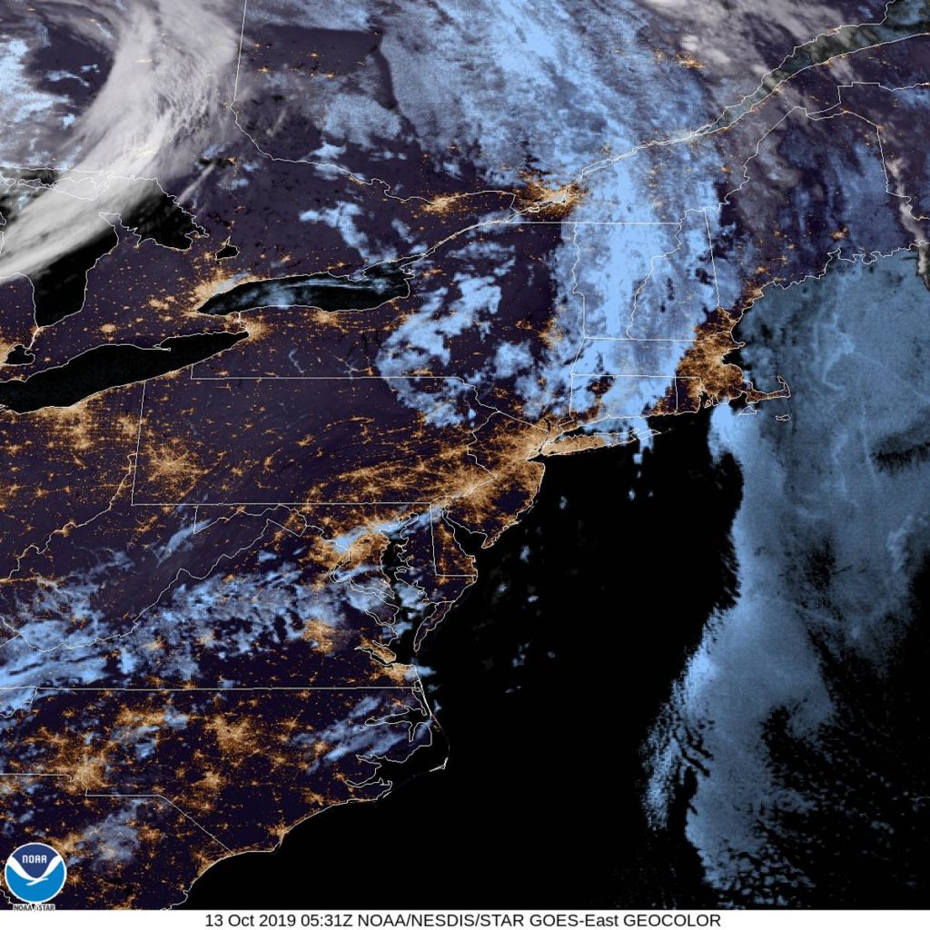
At 1254AM, ET, Boston was reporting clear skies and a temperature of 55 degrees. Some fog and clouds were settling in in the Berkshires and across Providence and South Boston, however it will be a race between clouds over the Cape and that fog, as temperatures should level off overnight if cloud cover encroaches. There is clear air over southern New England and in the Mid Atlantic, so if Boston is skirted by the clouds to the south, a foggy Sunday morning seems likely. The dominant feature in the eastern US is a deep area of low pressure in Ontario, with an occluded front through New England and a cold front stretching to the Carolinas. Independent circulation at the occlusion will shift off shore through tomorrow morning, and will deepen into a mostly independent feature, strengthened via good jet support. The amplification looks to be underestimated by the models at this point, but is also going to remain well east of Boston, bringing perhaps some low clouds and a little bit of wind on Monday. Tomorrow – Mostly sunny, High 66. Low 53 Monday – Mostly cloudy, High 65, Low 51
TWC: Tomorrow – Partly cloudy. High 68, Low 52 Monday – Sunshine and clouds mixed. High 67, Low 51
AW: Tomorrow – Clouds and breaks of sun High 68, Low 54 Monday – Clouds and breaks of sun, High 67, Low 52
NWS: Tomorrow – Mostly sunny, HIgh 66, Low 49 Monday – A chance of showers between 9am and noon. Partly sunny HIgh 66, Low 50
WB: Tomorrow – Mostly sunny, High 65, Low 50 Monday – Partly sunny with a 30% chance of showers, High 64, Low 51
WN: Tomorrow – Partly cloudy, HIgh 66, Low 50 Monday – Partly cloudy with scattered showers, High 66, Low 50
FIO: Tomorrow – Mostly cloudy throughout the day. High 65, Low 51 Monday – Partly cloudy throughout the day. High 63, Low 49
The NWS and friends are going for the shower potential, but it isn’t a popular forecast elsewhere. 60s seem pretty tolerable for October. Here is the satellite, with clear skies ready to move north.