
The early part of severe weather season gets it’s typical kickoff in what some people call the “Dixie Alley” which is focused primarily around Mississippi. We aren’t anticipating a massive outbreak on Saturday, but storms are indeed expected the next few days, starting today in west Texas and ending Saturday in Georgia and South Carolina. That leaves tomorrow for, you guessed it, Mississippi.
Low pressure is getting organized today in West Texas, giving rise to our first round of potential severe weather. Storms should be isolated, supercellular storms this afternoon and evening. Not everyone will see storms, but those that do will be threatened by tornadoes and large hail, centered around an area bound by Abilene, Fort Worth and Waco, but possible north into western Oklahoma as well.
The system will evolve overnight and after today’s activity, with the main, original area of low pressure rocketing towards the Great Lakes, and a surface low re-emerging in the ArkLaTex region. The entire system will be more sheared than it will be today, which will mean a lower likelihood of large standalone supercells, however a line of smaller such cells which ultimately form into a line of strong thunderstorms is the likely mode storms tomorrow evening. The greatest threat for severe weather will start around Shreveport before continuing through the night past Jackson and ultimately towards Montgomery.
By the time that Saturday rolls around. we are likely only to be tracking a line of strong thunderstorms. The tornado threat will be limited, but gusty straight line winds and hail are going to be pushing through the Peach, Palmetto and northern Sunshine state before dark on Saturday.
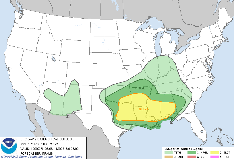
Two points to make about all of this. First, model guidance isn’t all on the same page for severe weather on any of these days. There could certainly be some big storms, including tornadic storms especially today, but tomorrow could ultimately be a low end severe weather day. There is only a slight risk for severe weather, accounting for the uncertainty.
Second, the individual storms will be strongest probably today, in Texas, and in the early afternoon over Louisiana and Arkansas, but will have the greatest coverage in Mississippi and eventually Alabama. After they redevelop tomorrow night, there likely is no turning these storms off until they are offshore.
As is always the case, stay tuned to your local weather authorities, and keep an eye on the weather. I described a narrow corridor, but storms are certainly possible for several miles on either side of this axis.