Not unlike today, there were strong thunderstorms over the lower Mississippi Valley. When we looked at the weather in Texarkana, many outlets sounded the alarm, prospecting for severe weather in the region. In fact, when storms really got going, Texarkana was entrenched in heavy rain and wasn’t destabilized enough for severe storms. Temperatures couldn’t even climb out of the 60s, but in better news, it remained cool because the system was almost out of the area already, and Sunday was a much quieter day. Forecast.io had nearly perfect numbers Actuals: Saturday – 1.26″ of rain, High 59, Low 55 Sunday – High 65, Low 45
Texarkana was named after three states it is near. It straddles the Texas-Arkansas border, and isn’t far from Louisiana. Sure, it’s closer to Oklahoma, but Texarklahomana is unwieldy.
At 953PM, CT, Texarkana was reporting a temperature of 59 degrees with clear skies. An oscillating boundary over the region is beginning to pivot back north as an area of low pressure develops over the Big Bend area of Texas. The front had pushed south, associated with a strong system now north of the Great Lakes, but the base of the parent trough is over Texas, and fostering development at the tail of the original front. Texarkana looks to be directly in the line of fire for some strong weather tomorrow. Heavy rain with strong thunderstorms will be possible throughout the day, with the best chance coming in the late morning. Because the activity is expected to arrive so early, Texarkana may avoid a particularly tough fate, which is more likely to the southeast, where a “Moderate Risk” of severe weather is being forecast. The dynamics of the system, particularly the inherent vorticity and widespread instability suggest that this storm could result in a large tornado outbreak. Overcast skies and the chance for light rain will continue through the early morning on Sunday, but clearing skies will arrive by lunch time and continue for the remainder of the weekend. Tomorrow – Rain with strong thunderstorms, High 64, Low 56 Sunday – Scattered showers early, then clearing, High 62, Low 45
TWC: Tomorrow – Variable clouds and becoming windy with strong thunderstorms. Damaging winds, large hail and possibly a tornado with some storms. High 59, Low 56 Sunday – Cloudy skies early, then partly cloudy in the afternoon. High 64, Low 45
AW: Tomorrow – Rain and severe thunderstorms; storms can bring flooding, hail, damaging winds and even a tornado High 64, Low 56 Sunday – Some clouds, then sunshine; breezy and cool High 61, Low 45
NWS: Tomorrow – Showers and thunderstorms. Some storms could be severe, with large hail and damaging winds High 65, Low 56 Sunday – A 20 percent chance of showers before 1pm. Cloudy, then gradually becoming mostly sunny High 62, Low 47
WB: Tomorrow – Showers and thunderstoms. Some thunderstorms may be severe with damaging winds, large hail and tornadoes in the afternoon. High 59, Low 57 Sunday – Mostly cloudy with a 20 percent chance of showers in the morning then partly cloudy in the afternoon, High 61, Low 47
WN: Tomorrow – Cloudy with heavy thunderstorms, High 65, Low 56 Sunday – Partly cloudy with isolated showers, High 62, Low 47
FIO: Tomorrow – Rain starting overnight and windy starting in the morning, continuing until afternoon. High 59, Low 55 Sunday – Mostly cloudy until evening. High 64, Low 45
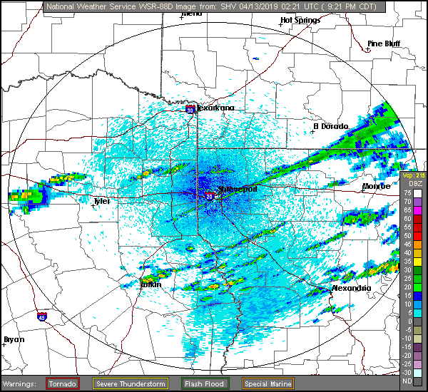
Here is a look at radar imagery of banded showers across the Ark-La-Tex. Below is a Facebook live event from Todd Warren, a meteorologist out of of NBC in Texarkan/Shreveport looking at the severe threat for tomorrow.