We forecast for Goldsboro, North Carolina at the beginning of the month, and as soon as the third, we were anticipating a day that reached nearly 90 degrees. It was 89 degrees on the third day of the month, but an upwelling of moisture on the 4th made things stickier, cloudier and a little bit cooler. There had been a forecast for some rain in Goldsboro, and while it has been stormy in the last couple of days in North Carolina, on the 4th, it was not. The Weather Channel had the first top forecast of May, Actuals: Friday, May 2nd, High 89, Low 64 Saturday, May 3rd, High 84, Low 68
My latest update referred back to Boise, and how close to spring it was getting even there. In the Carolinas, I think this would have been a pretty late breaking bit of news. They are aware.
At 255PM, ET, Goldsboro was reporting fair skies with a temperature of 85 degrees. Three was a bullseye of 90 nearby in Raleigh, but it is warm everywhere in the Carolinas. Fortunately, temperatures are not being boosted further by sweltering humidity, with dew points below 60. While things have been active in the center of the country, the east coast is dominated by an upper level ridge. The latent alto cumulus that just exists in the southeast throughout the summer thanks to oceanic and Gulf moisture seems to be reaching a barrier at the southern end of the Appalachians, and isn’t moving across theSome sun in the morning with increasing clouds during the afternoon. Very warm border from South Carolina. A boundary moving into the region from the west will arrive at the Appalachians on Saturday morning and struggle to get moisture into the Carolina Plains as well, however the persistent flow over the mountains will lead to some lee troughing. This localized circulation will draw some moisture into the area, and late shower activity is possible Saturday in Goldsboro. Tomorrow – Mostly sunny, High 89, Low 63 Saturday – Late clouds with a chance of showers, High 83, Low 64
TWC: Tomorrow – Some sun in the morning with increasing clouds during the afternoon. Very warm High 89, Low 63 Saturday – Cloudy skies. A stray shower or thunderstorm is possible. High 84, Low 64
AW: Tomorrow – Mostly sunny and very warm High 89. Low 63 Saturday – Cloudy with a couple of showers and a thunderstorm, mainly later High 83, Low 62
NWS: Tomorrow – Mostly sunny, High 90, Low 62 Saturday – A slight chance of showers, then a chance of showers and thunderstorms after 2pm. Mostly cloudy, High 84, Low 63
WB: Tomorrow – Partly Sunny, High 88, Low 68 Saturday – Mostly cloudy. A slight chance of showers in the morning then a chance of showers with a slight chance of thunderstorms in the afternoon. High 82, Low 66
WN: Tomorrow – Partly cloudy, High 87, Low 62 Saturday – Mostly cloudy with scattered showers and isolated storms, High 80, Low 64
CLI: Tomorrow – Mostly cloudy, High 88, Low 63 Saturday – Rain Showers, High 81, Low 64
You can see the scattered clouds through South Carolina that just filter out when you hit the Tar Heel State.
Merry Christmas! Here in South Florida, temperatures haven’t climbed above 60 since we arrived, temperatures which rival those of our forecast for Goldsboro back in the middle of the month. It’s colder there now, but on the 13th and 14th, temperatures lingered in the mid to upper 40s for highs, and dipped below freezing in the mornings. It seems like this might end up being Forecast.io’s last victory. End of an era. Actuals: December 13th, High 48, Low 30 December 14th, .01 inches of rain High 46, Low 27
Back to the Tar Heel State for a forecast in Goldsboro. A lot of ‘boros in North Carolina.
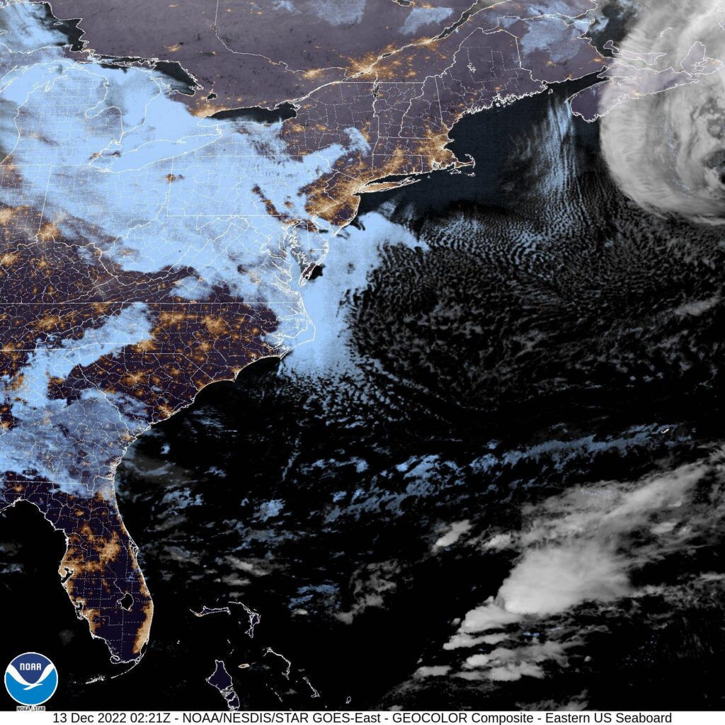
At 855PM, ET, Goldsboro was reporting mostly cloudy skies with a temperature of 42 degrees. A massive, deep area of low pressure is on it’s way north towards Nova Scotia, and is dangling a cold front that is primarily inactive onshore, save for a thick shield of clouds well to the north of the boundary, and more scattered activity in the Carolinas before the boundary is visible in south Georgia. If the clouds don’t fill in fast enough, Goldsboro may approach freezing, but tomorrow morning will be cloudy. While the low headed to Nova Scotia is stout, it is going to be quickly forgotten in the CONUS. A strong trough moving out of the Rockies is going to bring a warm front into the region. The feature is going to be a headline maker in the middle of the country with winter weather in the Northern Plains, and a perturbation in the southern part of the boundary is already bringing severe weather to the Southern Plains tonight. The severe storms will continue into the lower Mississippi Valley tomorrow, with continued storm activity along the Gulf Coast Wednesday. The severe storms and most unstable air will stay south of the Carolinas, but in the evening on Wednesday, rain will arrive in Goldsboro, leading to a soggy end of the week. Tomorrow – Cloudy early, then clearing, High 49, Low 30 Wednesday – Increasing clouds late, some showers before midnight, High 52, Low 28
TWC: Tomorrow – Sunshine. High 50, Low 29 Wednesday – Cloudy skies (Late rain) High 51, Low 27
AW: Tomorrow – Plenty of sun High 51, Low 31 Wednesday – Cloudy and chilly; a passing shower in the afternoon High 50, Low 28
NWS: Tomorrow – Sunny High 49, Low 29 Wednesday – Partly sunny, High 50, Low 29
WB: Tomorrow – Sunny, High 47, Low 30 Wednesday – Mostly cloudy, a slight chance of rain in the afternoon, High 47, Low 31
WN: Tomorrow – Sunny, High 48, Low 31 Wednesday – Partly cloudy, High 49, Low 30
FIO: Tomorrow – Clear throughout the day. High 48, Low 31 Wednesday – Mostly cloudy throughout the day (Late rain). High 49, Low 28
Here is a look at the satellite, with the Carolinas in the happy middle between sheaths of overcast.