
Meteorologists everywhere feel a twinge of guilt and pain every time severe weather targets life and property. We all love the weather, but when it turns ugly, it hurts a little differently, like we have somehow been betrayed. It’s worse when the bad weather is somewhat unanticipated.
Imelda was never anticipated to be a strong storm, in terms of central pressure, or wind speed, and it wasn’t anticipated, originally, to linger very long. Eventually, the storm did slow down and tracked over the same tract of land for about 48 hours. The result is images that resemble those from Hurricane Harvey, particularly between Houston and Beaumont.
Here is a look at
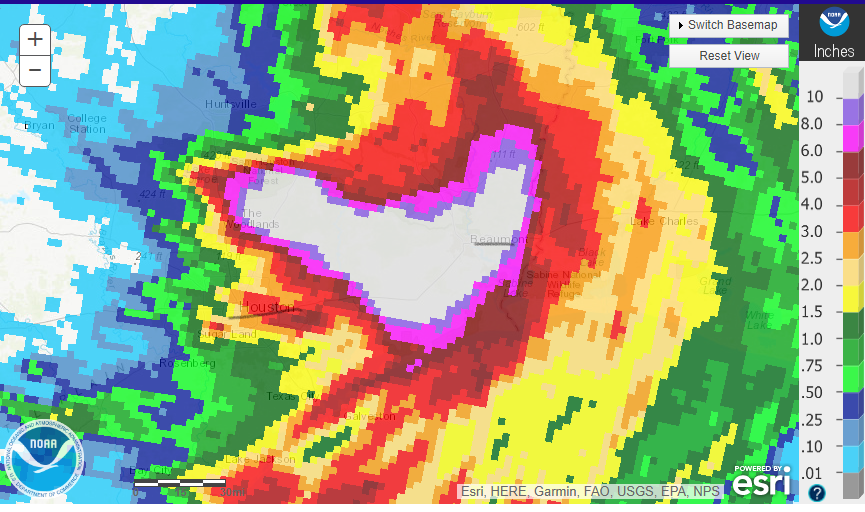
I’ve underlined Houston and Beaumont on the map which should show you something else from a couple of different perspectives. Either you will see this map, depending on your perspective. Either you will note that the is a lot of rain for a very large area, or you will note that this is actually a lot less rain than the area saw with Harvey. Both conclusions are true, and should be
Even though there is quantitatively less rain from Imelda, there was a lot of rain for a very large area IT was disruptive, deadly, destructive and evocative of the all time crisis that Harvey brought. This should underscore just what a nightmare Harvey was, but also sound an alarm about the eminent threat of any tropical feature. Just because Imelda’s torrential rain affected a smaller footprint doesn’t mean it wasn’t a major catastrophe. Imelda